The research employs an end-to-end deep reinforcement learning approach using raw 3D LiDAR data, with a voxel-based downsampling strategy to reduce input size and enable efficient policy learning in simulation.
End-to-End Crop Row Navigation via LiDAR-Based Deep Reinforcement Learning
Publication
Metrics
Quick Answers
What methodology did the authors use?
The research employs an end-to-end deep reinforcement learning approach using raw 3D LiDAR data, with a voxel-based downsampling strategy to reduce input size and enable efficient policy learning in simulation. More in Methodology →
What are the key results?
The system achieved 100% success rate in straight-row plantations but showed performance decline with increasing row curvature. — The proposed method reduced LiDAR input size by 95.83% through voxelization and 2D mapping, enabling efficient policy training without labeled datasets. More in Key Results →
Why is this work significant?
This research addresses reliable navigation in under-canopy agricultural environments where GNSS is unreliable, offering a self-contained learning-based system that reduces dependency on manual interfaces and labeled data. More in Significance →
What are the main limitations?
Performance degrades with more complex curved row patterns, indicating limited generalization beyond training conditions. — The system's effectiveness is constrained by the simulation environment, requiring further validation in real-world conditions. More in Limitations →
Abstract
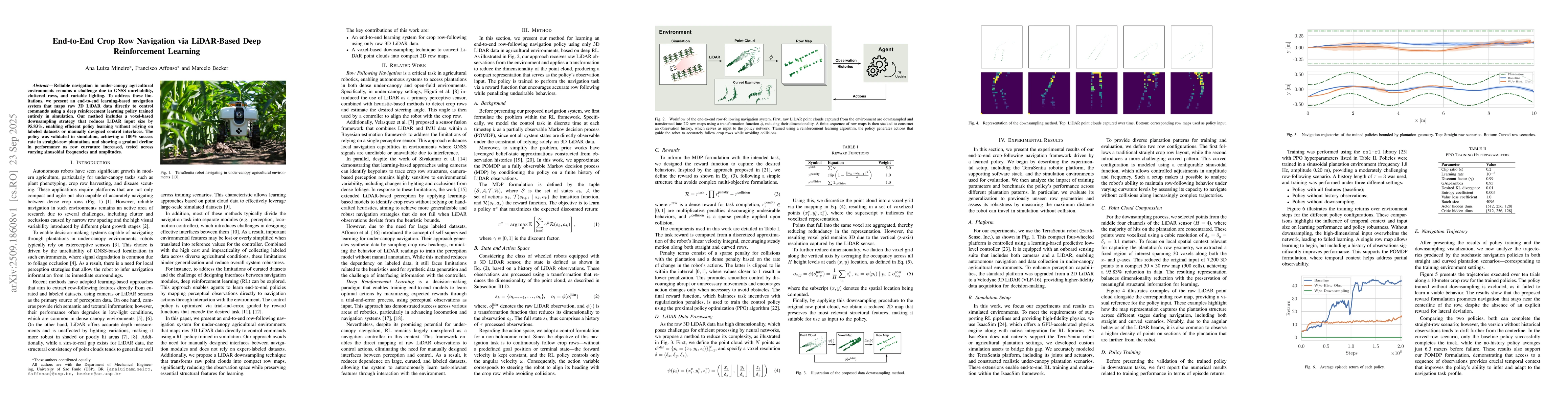
Reliable navigation in under-canopy agricultural environments remains a challenge due to GNSS unreliability, cluttered rows, and variable lighting. To address these limitations, we present an end-to-end learning-based navigation system that maps raw 3D LiDAR data directly to control commands using a deep reinforcement learning policy trained entirely in simulation. Our method includes a voxel-based downsampling strategy that reduces LiDAR input size by 95.83%, enabling efficient policy learning without relying on labeled datasets or manually designed control interfaces. The policy was validated in simulation, achieving a 100% success rate in straight-row plantations and showing a gradual decline in performance as row curvature increased, tested across varying sinusoidal frequencies and amplitudes.
Key Findings, in focus
Seven facets of this paper, analysed and brought into focus by AI.
This research addresses reliable navigation in under-canopy agricultural environments where GNSS is unreliable, offering a self-contained learning-based system that reduces dependency on manual interfaces and labeled data.
- The system achieved 100% success rate in straight-row plantations but showed performance decline with increasing row curvature.
- The proposed method reduced LiDAR input size by 95.83% through voxelization and 2D mapping, enabling efficient policy training without labeled datasets.
- The policy demonstrated robust navigation in simulated environments, maintaining row-following behavior across varying sinusoidal frequencies and amplitudes.
This research addresses reliable navigation in under-canopy agricultural environments where GNSS is unreliable, offering a self-contained learning-based system that reduces dependency on manual interfaces and labeled data.
Development of a voxel-based LiDAR data processing pipeline combined with a deep reinforcement learning policy for autonomous crop row navigation without manual control interfaces.
The work introduces an end-to-end learning system that directly maps raw LiDAR observations to control actions, eliminating the need for hand-crafted heuristics or labeled datasets in navigation.
- Performance degrades with more complex curved row patterns, indicating limited generalization beyond training conditions.
- The system's effectiveness is constrained by the simulation environment, requiring further validation in real-world conditions.
- Incorporate latent perception representations to improve generalization across diverse plantation layouts.
- Expand training layouts using domain randomization factors like plant size, spacing, and density.
- Validate the system in real-world agricultural environments to assess practical applicability.
Discussion 0