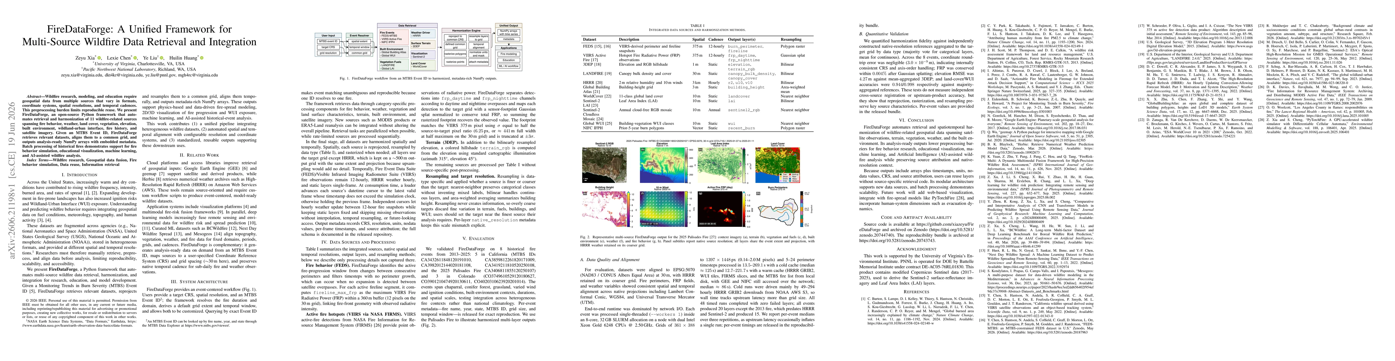
ArxivLens
ArXiv cs.CE cs.DB physics.geo-ph

FireDataForge: A Unified Framework for Multi-Source Wildfire Data Retrieval and Integration

Zeyu Xia, Lexie Chen, Ye Liu, Huilin Huang

2606.21198 Published Jun 19, 2026
View PDF

Publication

Published: Jun 19, 2026
Categories: cs.CE, cs.DB, physics.geo-ph

Metrics

Source: ArXiv

Quick Answers

What methodology did the authors use?

FireDataForge automates retrieval and harmonization of 11 wildfire-related data sources given an MTBS Event ID, reprojecting to a common grid, aligning temporal windows, rasterizing/adapting layers, and outputting analysis-ready NumPy arrays with embedded metadata. The pipeline includes event-centered resolution of fire duration, per-source processing, spatial and temporal reconciliation, and a configurable target CRS/grid, with parallelized retrieval where possible and sequential handling... More in Methodology →

What are the key results?

Quantitative validation showed negligible coordinate round-trip error across events (3.0×10⁻⁹ m) and conservation of FRP within 0.004% after Gaussian splatting, indicating high fidelity in reprojection and resampling. — Elevation RMSE against aggregated 3DEP references was 4.27 m, and land-cover/WUI classification accuracies were 0.944 and 0.998 respectively when compared to majority-aggregated references. More in Key Results →

Why is this work significant?

The framework reduces preprocessing barriers for reproducible wildfire research by providing a standardized, on-demand, analysis-ready data product that preserves source provenance and native resolutions while enabling applications in fire modeling, visualization, ML, and AI-assisted analysis. More in Significance →

What are the main limitations?

Evaluation validates internal consistency and alignment rather than independent cross-source accuracy; external validation against independent datasets is limited in scope. — HRRR data is retained at ~500 m output grid to preserve detail but may still constrain ultra-fine-temporal analyses for some applications. More in Limitations →

Paper Preview

Abstract

Wildfire research, modeling, and education require geospatial data from multiple sources that vary in formats, coordinate systems, spatial resolutions, and temporal cadences. This preprocessing burden limits reproducible reuse. We present FireDataForge, an open-source Python framework that automates retrieval and harmonization of 11 wildfire-related sources spanning fire behavior, weather, land cover, vegetation, elevation, built environment, wildland-urban interface, fire history, and satellite imagery. Given an MTBS Event ID, FireDataForge retrieves relevant datasets, aligns them to a common grid, and outputs analysis-ready NumPy arrays with embedded metadata. Batch processing of historical fires demonstrates support for fire behavior simulation, educational visualization, machine learning, and AI-assisted wildfire analysis.

Key Findings, in focus

Seven facets of this paper, analysed and brought into focus by AI.

AI-generated · verify against source Generated Jun 23, 2026
In focus · one-line synthesis

The framework reduces preprocessing barriers for reproducible wildfire research by providing a standardized, on-demand, analysis-ready data product that preserves source provenance and native resolutions while enabling applications in fire modeling, visualization, ML, and AI-assisted analysis.

01
MethodologyHow they did it

FireDataForge automates retrieval and harmonization of 11 wildfire-related data sources given an MTBS Event ID, reprojecting to a common grid, aligning temporal windows, rasterizing/adapting layers, and outputting analysis-ready NumPy arrays with embedded metadata. The pipeline includes event-centered resolution of fire duration, per-source processing, spatial and temporal reconciliation, and a configurable target CRS/grid, with parallelized retrieval where possible and sequential handling for rate-limited sources.

02
ResultsWhat they found
  • Quantitative validation showed negligible coordinate round-trip error across events (3.0×10⁻⁹ m) and conservation of FRP within 0.004% after Gaussian splatting, indicating high fidelity in reprojection and resampling.
  • Elevation RMSE against aggregated 3DEP references was 4.27 m, and land-cover/WUI classification accuracies were 0.944 and 0.998 respectively when compared to majority-aggregated references.
  • The framework produced harmonized multi-layer outputs for eight historical fires spanning diverse fuels, burn severities, and WUI contexts, demonstrating robustness to heterogeneous fire environments.
  • Per-event metadata (firename, year, MTBSID, grid size, temporal window) enables exact reproduction and unambiguous event matching across analyses.
  • Output metadata includes CRS, resolution, units, no-data values, per-frame timestamps, and source attribution, preserving native-resolution context within a unified format.
03
SignificanceWhy it matters

The framework reduces preprocessing barriers for reproducible wildfire research by providing a standardized, on-demand, analysis-ready data product that preserves source provenance and native resolutions while enabling applications in fire modeling, visualization, ML, and AI-assisted analysis.

04
Technical ContributionsWhat's new technically

A unified, event-centered data fusion pipeline that automatically retrieves, reprojects, temporally aligns, and rasterizes heterogeneous wildfire-related data sources into standardized, metadata-rich NumPy arrays with preserved native-resolution context and provenance.

05
NoveltyWhat sets it apart

First open-source framework to automate multi-source wildfire data retrieval, harmonization, and integration for MTBS events, enabling configurable CRS/grid outputs, per-frame temporal alignment, and analysis-ready arrays suitable for modeling, education, ML, and AI-assisted wildfire analysis.

06
LimitationsWhat to be cautious about
  • Evaluation validates internal consistency and alignment rather than independent cross-source accuracy; external validation against independent datasets is limited in scope.
  • HRRR data is retained at ~500 m output grid to preserve detail but may still constrain ultra-fine-temporal analyses for some applications.
  • Batch processing and new data sources require careful maintenance of source schemas; updates to any data source may necessitate pipeline adjustments.
07
Future WorkWhere it goes next
  • Develop web-based visualization to explore harmonized outputs interactively.
  • Integrate with fire-spread models such as PyTorchFire to enable end-to-end simulation workflows.
  • Incorporate human-system dimensions such as evacuation dynamics to enrich WUI impact analyses.

Paper Details

Paper ID: 2606.21198
Comments: 5 pages, 2 figures. Accepted to the 2026 IEEE International Conference on Information Reuse and Integration for Data Science (IEEE IRI 2026)
Categories:
cs.CE cs.DB physics.geo-ph

How to Cite This Paper

Reference manager: RIS EndNote


Discussion 0

This website uses cookies to ensure you get the best experience. Learn more