Generating a Training Dataset for Land Cover Classification to Advance Global Development
Publication
Metrics
AI Quick Summary
This paper develops a comprehensive training dataset for land cover classification using high-resolution Sentinel-2 imagery and GlobeLand30 labels, achieving over 80% accuracy with Random Forests. The goal is to expand this dataset for global agricultural and economic development applications.
Paper Preview
Abstract
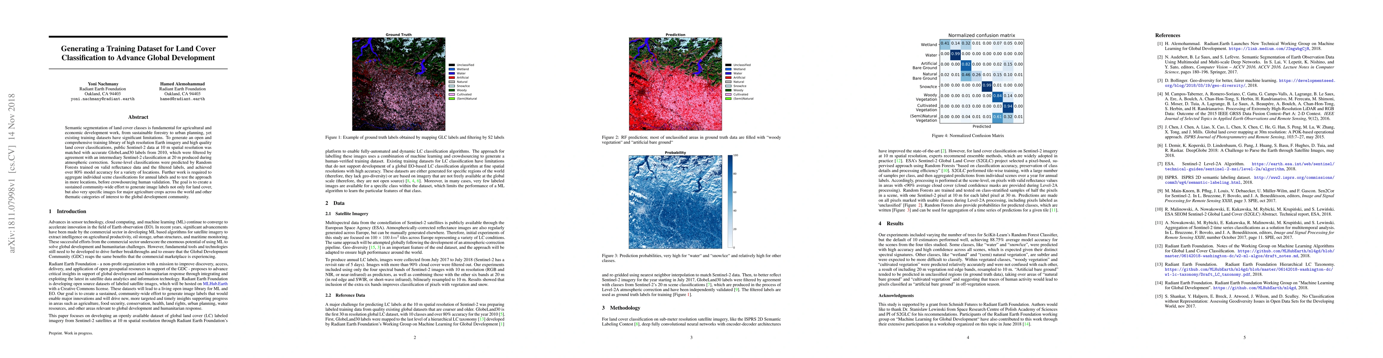
Semantic segmentation of land cover classes is fundamental for agricultural and economic development work, from sustainable forestry to urban planning, yet existing training datasets have significant limitations. To generate an open and comprehensive training library of high resolution Earth imagery and high quality land cover classifications, public Sentinel-2 data at 10 m spatial resolution was matched with accurate GlobeLand30 labels from 2010, which were filtered by agreement with an intermediary Sentinel-2 classification at 20 m produced during atmospheric correction. Scene-level classifications were predicted by Random Forests trained on valid reflectance data and the filtered labels, and achieved over 80% model accuracy for a variety of locations. Further work is required to aggregate individual scene classifications for annual labels and to test the approach in more locations, before crowdsourcing human validation. The goal is to create a sustained community-wide effort to generate image labels not only for land cover, but also very specific images for major agriculture crops across the world and other thematic categories of interest to the global development community.
AI Key Findings
Get AI-generated insights about this paper's methodology, results, significance, and more — seven facets brought into focus.
Impact
Paper Details
PDF Preview
Key Terms
Citation Network
Current paper (gray), citations (green), references (blue)
Display is limited for performance on very large graphs.
Discussion 0