The research employed a combination of spatial analysis and machine learning techniques to analyze crime patterns in New York City.
GeoPro-Net: Learning Interpretable Spatiotemporal Prediction Models through Statistically-Guided Geo-Prototyping
Publication
Metrics
AI Quick Summary
GeoPro-Net proposes an interpretable spatiotemporal model for forecasting events like crimes and accidents, utilizing statistical tests to extract and condense predictive patterns into Geo-concepts. The model achieves competitive performance while offering enhanced interpretability through inherent prototype learning and geographic-based pooling.
Quick Answers
What is "GeoPro-Net: Learning Interpretable Spatiotemporal Prediction Models through Statistically-Guided Geo-Prototyping" about?
GeoPro-Net proposes an interpretable spatiotemporal model for forecasting events like crimes and accidents, utilizing statistical tests to extract and condense predictive patterns into Geo-concepts. The model achieves competitive performance while offering enhanced interpretability through inherent prototype learning and geographic-based pooling.
What methodology did the authors use?
The research employed a combination of spatial analysis and machine learning techniques to analyze crime patterns in New York City. More in Methodology →
What are the key results?
GeoPro-Net achieved optimal performance with spatial concept pooling — Removing spatial pooling resulted in a significant decrease in performance More in Key Results →
Why is this work significant?
The study highlights the importance of considering geographic information in crime prediction models More in Significance →
What are the main limitations?
Limited sample size — Insufficient data on specific crime types More in Limitations →
Abstract
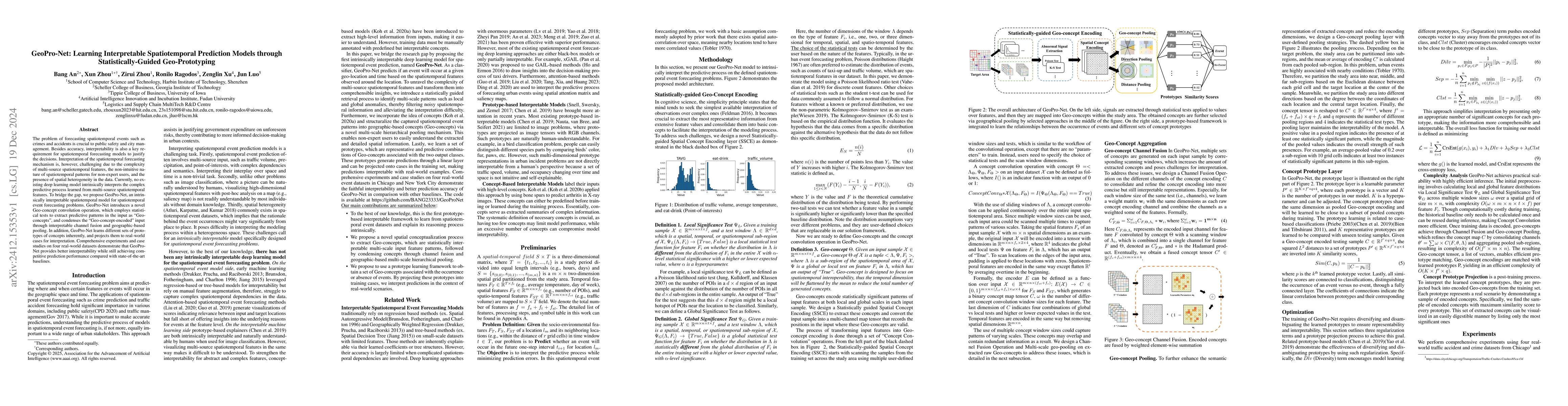
The problem of forecasting spatiotemporal events such as crimes and accidents is crucial to public safety and city management. Besides accuracy, interpretability is also a key requirement for spatiotemporal forecasting models to justify the decisions. Interpretation of the spatiotemporal forecasting mechanism is, however, challenging due to the complexity of multi-source spatiotemporal features, the non-intuitive nature of spatiotemporal patterns for non-expert users, and the presence of spatial heterogeneity in the data. Currently, no existing deep learning model intrinsically interprets the complex predictive process learned from multi-source spatiotemporal features. To bridge the gap, we propose GeoPro-Net, an intrinsically interpretable spatiotemporal model for spatiotemporal event forecasting problems. GeoPro-Net introduces a novel Geo-concept convolution operation, which employs statistical tests to extract predictive patterns in the input as Geo-concepts, and condenses the Geo-concept-encoded input through interpretable channel fusion and geographic-based pooling. In addition, GeoPro-Net learns different sets of prototypes of concepts inherently, and projects them to real-world cases for interpretation. Comprehensive experiments and case studies on four real-world datasets demonstrate that GeoPro-Net provides better interpretability while still achieving competitive prediction performance compared with state-of-the-art baselines.
Key Findings, in focus
Seven facets of this paper, analysed and brought into focus by AI.
The study highlights the importance of considering geographic information in crime prediction models
- GeoPro-Net achieved optimal performance with spatial concept pooling
- Removing spatial pooling resulted in a significant decrease in performance
- ASTGCN provided limited insights into the relationship between events and different features
The study highlights the importance of considering geographic information in crime prediction models
The development of GeoPro-Net, a novel approach to incorporating geographic information in crime prediction models
GeoPro-Net's use of spatial concept pooling and attention mechanisms provides a unique perspective on analyzing complex urban data
- Limited sample size
- Insufficient data on specific crime types
- Developing more accurate spatial analysis techniques
- Integrating additional data sources into the model
Authors
PDF Preview
Related Papers
No references found for this paper.
Discussion 0