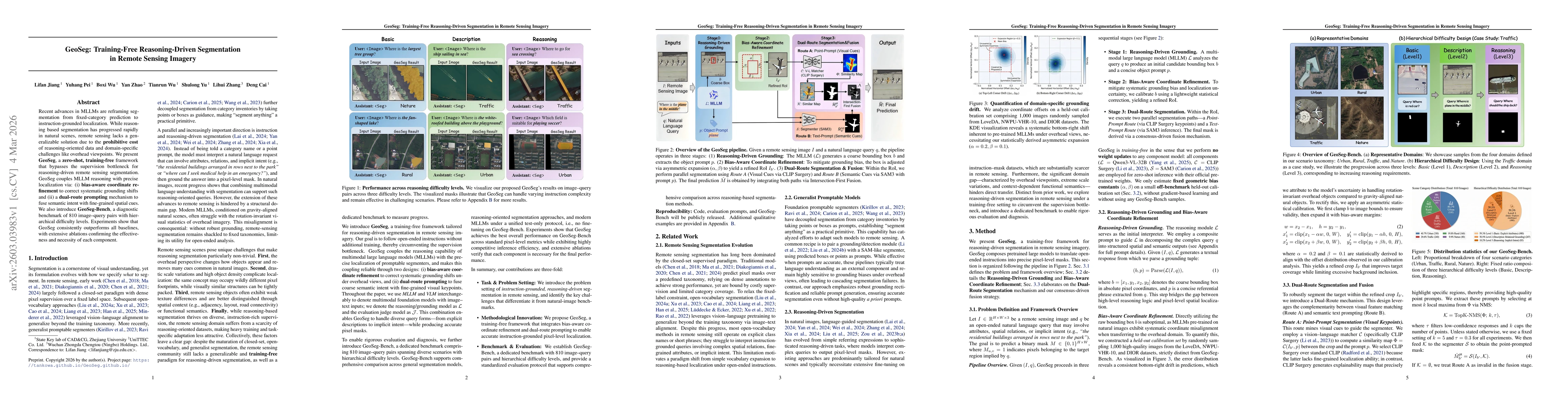
GeoSeg employs a training-free framework that couples large multimodal language model (MLLM) reasoning with precise localization via bias-aware coordinate refinement and a dual-route prompting mechanism (visual point prompts and semantic text prompts). The system is evaluated on the newly introduced GeoSeg-Bench (810 image–query pairs) and the SegEarth‑R2 training set using pixel-level metrics (IoU, Dice, etc.) and an MLLM-as-a-judge protocol for faithfulness, localization, and robustness.
GeoSeg: Training-Free Reasoning-Driven Segmentation in Remote Sensing Imagery
Publication
Metrics
Quick Answers
What methodology did the authors use?
GeoSeg employs a training-free framework that couples large multimodal language model (MLLM) reasoning with precise localization via bias-aware coordinate refinement and a dual-route prompting mechanism (visual point prompts and semantic text prompts). The system is evaluated on the newly introduced GeoSeg-Bench (810 image–query pairs) and the SegEarth‑R2 training set using pixel-level metrics (IoU, Dice, etc.) and an MLLM-as-a-judge protocol for... More in Methodology →
What are the key results?
GeoSeg achieves state‑of‑the‑art zero‑shot performance, attaining 56.4% IoU and 64.2% Dice on GeoSeg‑Bench, surpassing all 13 baselines. Ablation studies confirm that both BoxRefinement and the dual‑route strategy are essential, with removal of either causing significant drops (IoU to 43.2% or 51.1%). — Human and MLLM judge evaluations rank GeoSeg first across faithfulness, localization, and robustness, with scores of 4.35, 4.12,... More in Key Results →
Abstract
Recent advances in MLLMs are reframing segmentation from fixed-category prediction to instruction-grounded localization. While reasoning based segmentation has progressed rapidly in natural scenes, remote sensing lacks a generalizable solution due to the prohibitive cost of reasoning-oriented data and domain-specific challenges like overhead viewpoints. We present GeoSeg, a zero-shot, training-free framework that bypasses the supervision bottleneck for reasoning-driven remote sensing segmentation. GeoSeg couples MLLM reasoning with precise localization via: (i) bias-aware coordinate refinement to correct systematic grounding shifts and (ii) a dual-route prompting mechanism to fuse semantic intent with fine-grained spatial cues. We also introduce GeoSeg-Bench, a diagnostic benchmark of 810 image--query pairs with hierarchical difficulty levels. Experiments show that GeoSeg consistently outperforms all baselines, with extensive ablations confirming the effectiveness and necessity of each component.
Key Findings, in focus
Seven facets of this paper, analysed and brought into focus by AI.
GeoSeg employs a training-free framework that couples large multimodal language model (MLLM) reasoning with precise localization via bias-aware coordinate refinement and a dual-route prompting mechanism (visual point prompts and semantic text prompts).
- GeoSeg achieves state‑of‑the‑art zero‑shot performance, attaining 56.4% IoU and 64.2% Dice on GeoSeg‑Bench, surpassing all 13 baselines. Ablation studies confirm that both BoxRefinement and the dual‑route strategy are essential, with removal of either causing significant drops (IoU to 43.2% or 51.1%).
- Human and MLLM judge evaluations rank GeoSeg first across faithfulness, localization, and robustness, with scores of 4.35, 4.12, and 4.20 respectively, outperforming existing reasoning‑segmentation methods.
Discussion 0