ArxivLens

Publication

Published: Apr 16, 2026
Categories: cs.CV

Metrics

Source: ArXiv

Quick Answers

What methodology did the authors use?

A modular framework that fuses a track segmentation network (DDRNet), an object detector (YOLOv11), and a fine‑tuned monocular depth estimator (MiDaS) with sparse LiDAR points; the LiDAR depth is projected onto the image, linearly interpolated, and added to the dense depth map for refined distance estimation, all evaluated on the synthetic SynDRA dataset. More in Methodology →

What are the key results?

MAE of 0.63 m for distance estimation after LiDAR refinement, demonstrating accurate absolute depth predictions. — Detection TPR ranging from 63 % to 99 % and IoU between 0.69 and 0.80 across classes such as person, vehicle, animal, tool, and train. More in Key Results →

Paper Preview

Abstract

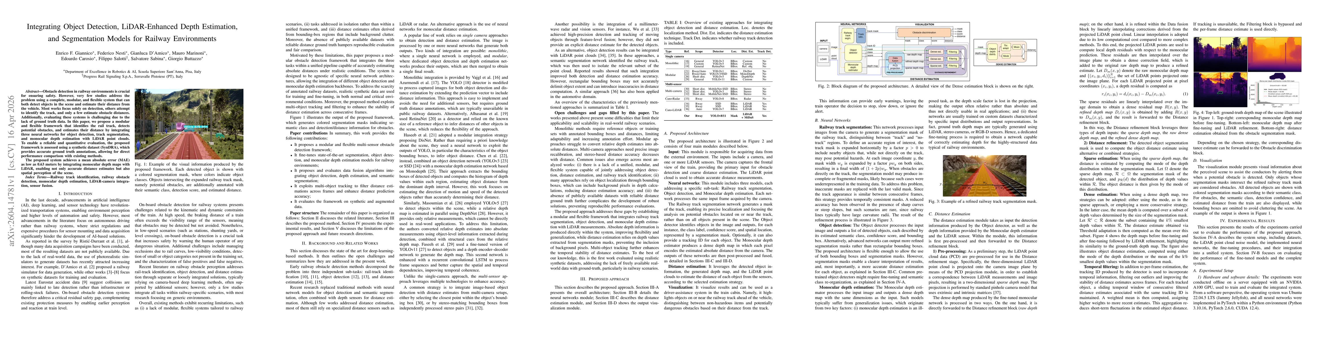
Obstacle detection in railway environments is crucial for ensuring safety. However, very few studies address the problem using a complete, modular, and flexible system that can both detect objects in the scene and estimate their distance from the vehicle. Most works focus solely on detection, others attempt to identify the track, and only a few estimate obstacle distances. Additionally, evaluating these systems is challenging due to the lack of ground truth data. In this paper, we propose a modular and flexible framework that identifies the rail track, detects potential obstacles, and estimates their distance by integrating three neural networks for object detection, track segmentation, and monocular depth estimation with LiDAR point clouds. To enable a reliable and quantitative evaluation, the proposed framework is assessed using a synthetic dataset (SynDRA), which provides accurate ground truth annotations, allowing for direct performance comparison with existing methods. The proposed system achieves a mean absolute error (MAE) as low as 0.63 meters by integrating monocular depth maps with LiDAR, enabling not only accurate distance estimates but also spatial perception of the scene.

Key Findings, in focus

Seven facets of this paper, analysed and brought into focus by AI.

AI-generated · verify against source Generated Apr 17, 2026
In focus · one-line synthesis

A modular framework that fuses a track segmentation network (DDRNet), an object detector (YOLOv11), and a fine‑tuned monocular depth estimator (MiDaS) with sparse LiDAR points; the LiDAR depth is projected onto the image, linearly interpolated, and added to the dense depth map for refined distance estimation, all evaluated on the synthetic SynDRA dataset.

01
MethodologyHow they did it

A modular framework that fuses a track segmentation network (DDRNet), an object detector (YOLOv11), and a fine‑tuned monocular depth estimator (MiDaS) with sparse LiDAR points; the LiDAR depth is projected onto the image, linearly interpolated, and added to the dense depth map for refined distance estimation, all evaluated on the synthetic SynDRA dataset.

02
ResultsWhat they found
  • MAE of 0.63 m for distance estimation after LiDAR refinement, demonstrating accurate absolute depth predictions.
  • Detection TPR ranging from 63 % to 99 % and IoU between 0.69 and 0.80 across classes such as person, vehicle, animal, tool, and train.
  • Dense depth refinement reduced MAE from 12–94 m (raw MiDaS) to 0.6–1.5 m (refined) across different scenarios, confirming the effectiveness of LiDAR fusion.
  • Temporal filtering with tracking IDs further stabilised distance estimates, improving short‑term consistency.
  • The system achieved real‑time inference on a single GPU with a baseline processing time of ~1.7 s per frame, indicating feasibility for deployment.

Paper Details

Paper ID: 2604.14781
Comments: Under submission for publication
Categories:
cs.CV

How to Cite This Paper

Reference manager: RIS EndNote

Related Papers

4 found


Discussion 0

This website uses cookies to ensure you get the best experience. Learn more