The research proposes InterKey, a framework that leverages road intersections as cross-modal keypoints between LiDAR point clouds and OpenStreetMap (OSM) data. It jointly encodes road and building imprints into compact binary descriptors and introduces discrepancy mitigation, orientation determination, and area-equalized sampling strategies to bridge the modality gap between perception data and map abstractions.
InterKey: Cross-modal Intersection Keypoints for Global Localization on OpenStreetMap
Publication
Metrics
Quick Answers
What methodology did the authors use?
The research proposes InterKey, a framework that leverages road intersections as cross-modal keypoints between LiDAR point clouds and OpenStreetMap (OSM) data. It jointly encodes road and building imprints into compact binary descriptors and introduces discrepancy mitigation, orientation determination, and area-equalized sampling strategies to bridge the modality gap between perception data and map abstractions. More in Methodology →
What are the key results?
InterKey achieves state-of-the-art performance on the KITTI dataset, outperforming existing OSM-based localization methods like OSMContext and BDF by 1.85x and 2.7x in average Recall@5m. — The method demonstrates robust localization accuracy across diverse road networks and building configurations, with 81.15% Recall@5m on sequence 00 and 89.03% on sequence 05. More in Key Results →
Why is this work significant?
This research addresses the critical need for reliable global localization in GPS-denied environments by utilizing distinctive and robust landmarks like road intersections. It enhances the scalability and practicality of OSM-based localization systems for autonomous vehicles. More in Significance →
What are the main limitations?
The method relies on semantic segmentation of LiDAR data to extract road and building imprints, which may introduce errors in complex urban environments. — Performance may degrade in areas with sparse or low-contrast road networks and buildings. More in Limitations →
Abstract
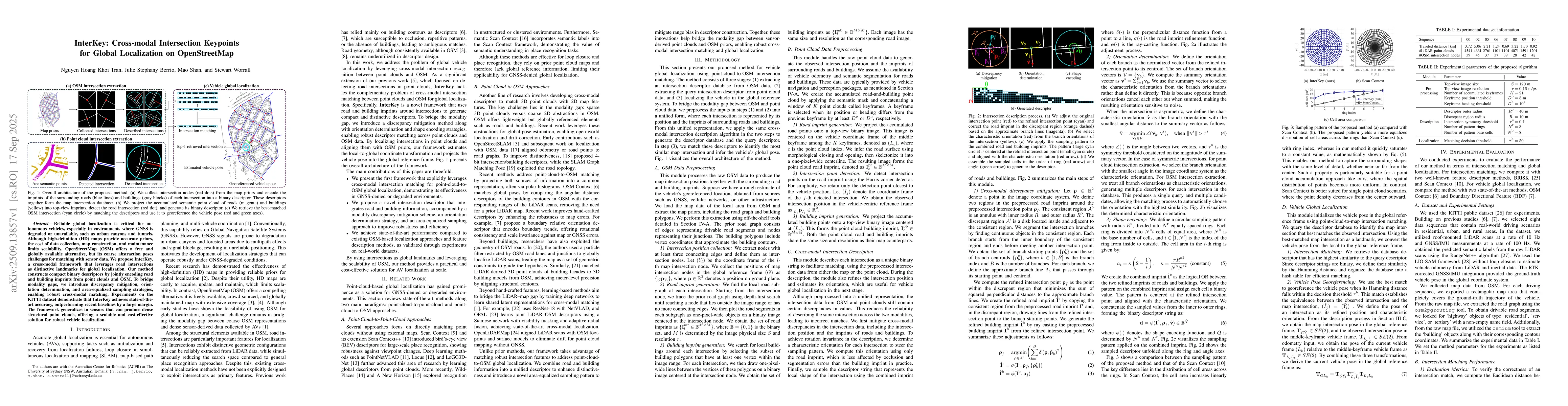
Reliable global localization is critical for autonomous vehicles, especially in environments where GNSS is degraded or unavailable, such as urban canyons and tunnels. Although high-definition (HD) maps provide accurate priors, the cost of data collection, map construction, and maintenance limits scalability. OpenStreetMap (OSM) offers a free and globally available alternative, but its coarse abstraction poses challenges for matching with sensor data. We propose InterKey, a cross-modal framework that leverages road intersections as distinctive landmarks for global localization. Our method constructs compact binary descriptors by jointly encoding road and building imprints from point clouds and OSM. To bridge modality gaps, we introduce discrepancy mitigation, orientation determination, and area-equalized sampling strategies, enabling robust cross-modal matching. Experiments on the KITTI dataset demonstrate that InterKey achieves state-of-the-art accuracy, outperforming recent baselines by a large margin. The framework generalizes to sensors that can produce dense structural point clouds, offering a scalable and cost-effective solution for robust vehicle localization.
Key Findings, in focus
Seven facets of this paper, analysed and brought into focus by AI.
This research addresses the critical need for reliable global localization in GPS-denied environments by utilizing distinctive and robust landmarks like road intersections.
- InterKey achieves state-of-the-art performance on the KITTI dataset, outperforming existing OSM-based localization methods like OSMContext and BDF by 1.85x and 2.7x in average Recall@5m.
- The method demonstrates robust localization accuracy across diverse road networks and building configurations, with 81.15% Recall@5m on sequence 00 and 89.03% on sequence 05.
- Combining road and building imprints in descriptors significantly improves localization performance, especially in scenarios where buildings are obscured by trees.
This research addresses the critical need for reliable global localization in GPS-denied environments by utilizing distinctive and robust landmarks like road intersections. It enhances the scalability and practicality of OSM-based localization systems for autonomous vehicles.
The technical contribution lies in the development of a novel cross-modal descriptor encoding method that effectively bridges the gap between LiDAR point clouds and OSM map abstractions through discrepancy mitigation, orientation determination, and area-equalized sampling strategies.
The novelty of this work is its focus on road intersections as cross-modal keypoints between LiDAR and OSM data, combined with a unique descriptor construction approach that integrates both road and building imprints while addressing modality discrepancies through specialized sampling and orientation strategies.
- The method relies on semantic segmentation of LiDAR data to extract road and building imprints, which may introduce errors in complex urban environments.
- Performance may degrade in areas with sparse or low-contrast road networks and buildings.
- Incorporate visual cues and multi-modal data to further improve descriptor robustness.
- Explore purely camera- or radar-based implementations to broaden applicability across different sensing platforms.
- Extend the framework to handle dynamic obstacles and varying weather conditions.
Discussion 0