A three-stage pipeline that first builds a 3D Gaussian Splatting (3DGS) scene and augments the retrieval database with synthetic views, then estimates a coarse pose via relative pose regression (ReLoc3r) combined with depth-anchored photometric search, and finally refines the pose with a Laplacian-based reliability mask guiding photometric optimization.
LSGS-Loc: Towards Robust 3DGS-Based Visual Localization for Large-Scale UAV Scenarios
Publication
Metrics
Quick Answers
What methodology did the authors use?
A three-stage pipeline that first builds a 3D Gaussian Splatting (3DGS) scene and augments the retrieval database with synthetic views, then estimates a coarse pose via relative pose regression (ReLoc3r) combined with depth-anchored photometric search, and finally refines the pose with a Laplacian-based reliability mask guiding photometric optimization. More in Methodology →
What are the key results?
Achieves centimeter-level accuracy on five large-scale UAV datasets, outperforming state-of-the-art structure-based, coordinate regression, and 3DGS methods. — Reaches >94% recall under a strict 1°/10 m threshold, demonstrating robust convergence from coarse initialization. More in Key Results →
Why is this work significant?
Provides the first robust, high-precision visual localization framework for large-scale UAV scenarios using 3DGS, enabling reliable autonomous navigation in complex, textureless, and dynamic environments. More in Significance →
What are the main limitations?
Relies on the quality of the 3DGS reconstruction; severe rendering artifacts can still degrade performance. — Requires a dense set of synthetic views, which increases preprocessing time and storage overhead. More in Limitations →
Abstract
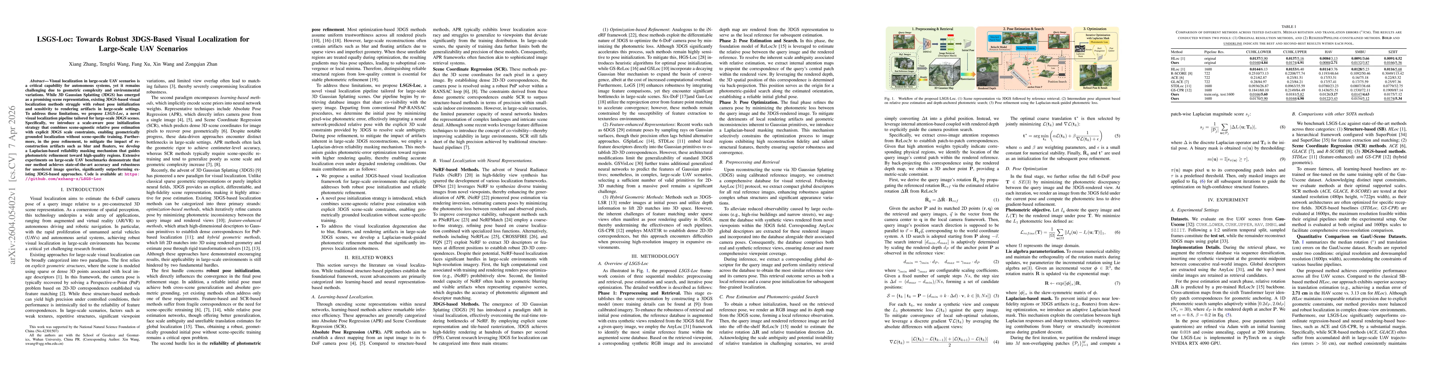
Visual localization in large-scale UAV scenarios is a critical capability for autonomous systems, yet it remains challenging due to geometric complexity and environmental variations. While 3D Gaussian Splatting (3DGS) has emerged as a promising scene representation, existing 3DGS-based visual localization methods struggle with robust pose initialization and sensitivity to rendering artifacts in large-scale settings. To address these limitations, we propose LSGS-Loc, a novel visual localization pipeline tailored for large-scale 3DGS scenes. Specifically, we introduce a scale-aware pose initialization strategy that combines scene-agnostic relative pose estimation with explicit 3DGS scale constraints, enabling geometrically grounded localization without scene-specific training. Furthermore, in the pose refinement, to mitigate the impact of reconstruction artifacts such as blur and floaters, we develop a Laplacian-based reliability masking mechanism that guides photometric refinement toward high-quality regions. Extensive experiments on large-scale UAV benchmarks demonstrate that our method achieves state-of-the-art accuracy and robustness for unordered image queries, significantly outperforming existing 3DGS-based approaches. Code is available at: https://github.com/xzhang-z/LSGS-Loc
Key Findings, in focus
Seven facets of this paper, analysed and brought into focus by AI.
Provides the first robust, high-precision visual localization framework for large-scale UAV scenarios using 3DGS, enabling reliable autonomous navigation in complex, textureless, and dynamic environments.
- Achieves centimeter-level accuracy on five large-scale UAV datasets, outperforming state-of-the-art structure-based, coordinate regression, and 3DGS methods.
- Reaches >94% recall under a strict 1°/10 m threshold, demonstrating robust convergence from coarse initialization.
- Ablation studies confirm that the Laplacian mask and database augmentation each reduce median rotation and translation errors by up to 80 % in challenging scenes.
Provides the first robust, high-precision visual localization framework for large-scale UAV scenarios using 3DGS, enabling reliable autonomous navigation in complex, textureless, and dynamic environments.
A scale-aware pose initialization that fuses relative pose regression with depth-anchored anchor points, and a Laplacian-based mask that selectively constrains photometric refinement to high-fidelity regions.
Combines 3DGS scene representation with synthetic view augmentation, depth-anchored pose search, and a novel Laplacian reliability mask—an unprecedented integration that yields state-of-the-art accuracy for large-scale UAV visual localization.
- Relies on the quality of the 3DGS reconstruction; severe rendering artifacts can still degrade performance.
- Requires a dense set of synthetic views, which increases preprocessing time and storage overhead.
- Integrate dynamic scene handling and online map updates to support changing environments.
- Explore real-time deployment on embedded UAV hardware by optimizing rendering and optimization pipelines.
Discussion 0