ArxivLens

Publication

Published: Jan 29, 2026
Categories: cs.CL

Metrics

Source: ArXiv

Quick Answers

What methodology did the authors use?

The research introduces a multi-hop reasoning framework integrated with retrieval-augmented generation (RAG) and tool execution for complex geospatial queries. It employs a combination of spreadsheet analysis, document querying, and terrain map interpretation to derive conclusions. More in Methodology →

What are the key results?

State-of-the-art models struggle with multi-hop geospatial reasoning tasks requiring integration of heterogeneous data sources. — The proposed framework achieves higher accuracy in troop deployment scenarios by combining spatial data with population distribution analysis. More in Key Results →

Why is this work significant?

This research advances the capabilities of AI systems in handling complex military and geospatial decision-making tasks, with potential applications in defense planning, disaster response, and urban management. More in Significance →

What are the main limitations?

The framework relies on structured data formats which may limit its applicability to real-world unstructured environments. — The performance is highly dependent on the quality and completeness of the input data sources. More in Limitations →

Paper Preview

Abstract

As large language models (LLMs) are applied to increasingly longer and more complex tasks, there is a growing need for realistic long-context benchmarks that require selective reading and integration of heterogeneous, multi-modal information sources. This need is especially acute for geospatial planning problems, such as those found in planning for large-scale military operations, which demand fast and accurate reasoning over maps, orders, intelligence reports, and other distributed data. To address this gap, we present MilSCORE (Military Scenario Contextual Reasoning), to our knowledge the first scenario-level dataset of expert-authored, multi-hop questions grounded in a complex, simulated military planning scenario used for training. MilSCORE is designed to evaluate high-stakes decision-making and planning, probing LLMs' ability to combine tactical and spatial reasoning across multiple sources and to reason over long-horizon, geospatially rich context. The benchmark includes a diverse set of question types across seven categories targeting both factual recall and multi-step reasoning about constraints, strategy, and spatial analysis. We provide an evaluation protocol and report baseline results for a range of contemporary vision-language models. Our findings highlight substantial headroom on MilSCORE, indicating that current systems struggle with realistic, scenario-level long-context planning, and positioning MilSCORE as a challenging testbed for future work.
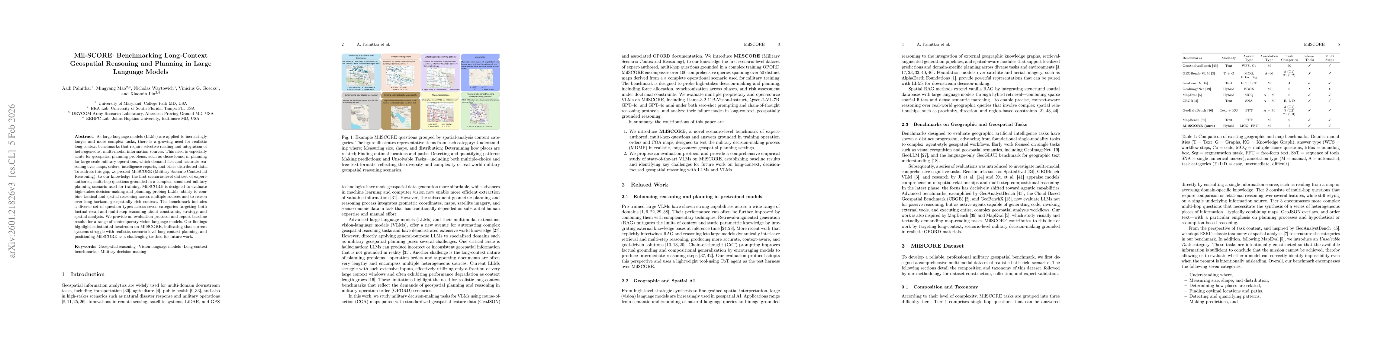
Key Findings, in focus

Seven facets of this paper, analysed and brought into focus by AI.

AI-generated · verify against source Generated Jan 30, 2026
In focus · one-line synthesis

This research advances the capabilities of AI systems in handling complex military and geospatial decision-making tasks, with potential applications in defense planning, disaster response, and urban management.

01
MethodologyHow they did it

The research introduces a multi-hop reasoning framework integrated with retrieval-augmented generation (RAG) and tool execution for complex geospatial queries. It employs a combination of spreadsheet analysis, document querying, and terrain map interpretation to derive conclusions.

02
ResultsWhat they found
  • State-of-the-art models struggle with multi-hop geospatial reasoning tasks requiring integration of heterogeneous data sources.
  • The proposed framework achieves higher accuracy in troop deployment scenarios by combining spatial data with population distribution analysis.
  • The methodology demonstrates effective handling of complex military operational planning tasks through iterative data inspection and reasoning.
03
SignificanceWhy it matters

This research advances the capabilities of AI systems in handling complex military and geospatial decision-making tasks, with potential applications in defense planning, disaster response, and urban management.

04
Technical ContributionsWhat's new technically

The paper presents a novel integration of RAG with tool execution for multi-hop reasoning, enabling complex geospatial queries to be resolved through systematic data inspection and logical inference.

05
NoveltyWhat sets it apart

This work introduces a unique combination of retrieval-augmented generation with operational planning tools, providing a new approach to handling complex, multi-source geospatial reasoning tasks in military contexts.

06
LimitationsWhat to be cautious about
  • The framework relies on structured data formats which may limit its applicability to real-world unstructured environments.
  • The performance is highly dependent on the quality and completeness of the input data sources.
07
Future WorkWhere it goes next
  • Developing more robust data preprocessing techniques for unstructured geospatial information
  • Enhancing the framework's ability to handle temporal aspects in geospatial reasoning
  • Exploring the integration of real-time data sources for dynamic decision-making

Paper Details

Paper ID: 2601.21826
Categories:
cs.CL

How to Cite This Paper

Reference manager: RIS EndNote


Discussion 0

This website uses cookies to ensure you get the best experience. Learn more