01
MethodologyHow they did it
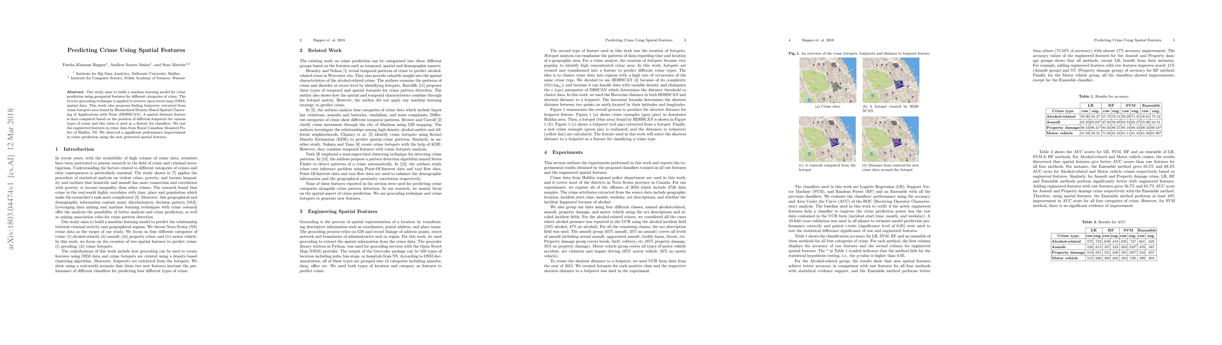
The research used geolocated data to create spatial features derived from geocoding and shortest distance to a hotpoint.
This study develops a machine learning model for crime prediction using geospatial features, employing reverse geocoding for OSM data and HDBSCAN to identify crime hotspots. The spatial distance between these hotspots serves as a predictive feature, showing significant performance improvement in crime prediction for data from Halifax, NS.
This study develops a machine learning model for crime prediction using geospatial features, employing reverse geocoding for OSM data and HDBSCAN to identify crime hotspots. The spatial distance between these hotspots serves as a predictive feature, showing significant performance improvement in crime prediction for data from Halifax, NS.
The research used geolocated data to create spatial features derived from geocoding and shortest distance to a hotpoint. More in Methodology →
Significant improvements in accuracy were found when the new features were added to the tested classifiers. — The Ensemble method performed at least 10% improvement in AUC score for all four categories of crime. More in Key Results →
This research is important because it explores the creation of spatial features from geolocated data, which can improve crime prediction models. More in Significance →
The study focused on real-world datasets, but data discrimination is another important concern that needs to be addressed. — Transfer learning from one dataset to another Canadian province is a suggested direction for future research. More in Limitations →
Our study aims to build a machine learning model for crime prediction using geospatial features for different categories of crime. The reverse geocoding technique is applied to retrieve open street map (OSM) spatial data. This study also proposes finding hotpoints extracted from crime hotspots area found by Hierarchical Density-Based Spatial Clustering of Applications with Noise (HDBSCAN). A spatial distance feature is then computed based on the position of different hotpoints for various types of crime and this value is used as a feature for classifiers. We test the engineered features in crime data from Royal Canadian Mounted Police of Halifax, NS. We observed a significant performance improvement in crime prediction using the new generated spatial features.
Seven facets of this paper, analysed and brought into focus by AI.
This research is important because it explores the creation of spatial features from geolocated data, which can improve crime prediction models.
The research used geolocated data to create spatial features derived from geocoding and shortest distance to a hotpoint.
This research is important because it explores the creation of spatial features from geolocated data, which can improve crime prediction models.
The creation of spatial features derived from geocoding and shortest distance to a hotpoint is a novel technical contribution.
This work is novel because it explores the use of spatial features in crime prediction models, which can improve accuracy and effectiveness.
Current paper (gray), citations (green), references (blue)
Display is limited for performance on very large graphs.
Discussion 0