Publication
Metrics
Quick Actions
Quick Answers
What methodology did the authors use?
The research employs a hybrid approach combining satellite remote sensing data (SAR and optical imagery) with field-measured plot data to estimate biomass and canopy metrics in tropical ecosystems. It utilizes advanced machine learning models trained on multi-source datasets to improve accuracy and spatial coverage. More in Methodology →
What are the key results?
Achieved high accuracy in estimating canopy height and cover using SAR and optical data fusion — Demonstrated the effectiveness of field plot data in calibrating and validating remote sensing estimates More in Key Results →
Why is this work significant?
This research provides a scalable framework for monitoring forest biomass and ecosystem health, supporting climate change mitigation efforts and sustainable land management. It bridges the gap between remote sensing and ground truth data for improved ecological assessments. More in Significance →
What are the main limitations?
Dependence on high-quality field data which may not be available in all regions — Potential inaccuracies in SAR data due to atmospheric interference and surface roughness More in Limitations →
Abstract
Concept Bottleneck Models (CBMs) improve the explainability of black-box Deep Learning (DL) by introducing intermediate semantic concepts. However, standard CBMs often overlook domain-specific relationships and causal mechanisms, and their dependence on complete concept labels limits applicability in scientific domains where supervision is sparse but processes are well defined. To address this, we propose the Process-Guided Concept Bottleneck Model (PG-CBM), an extension of CBMs which constrains learning to follow domain-defined causal mechanisms through biophysically meaningful intermediate concepts. Using above ground biomass density estimation from Earth Observation data as a case study, we show that PG-CBM reduces error and bias compared to multiple benchmarks, whilst leveraging multi-source heterogeneous training data and producing interpretable intermediate outputs. Beyond improved accuracy, PG-CBM enhances transparency, enables detection of spurious learning, and provides scientific insights, representing a step toward more trustworthy AI systems in scientific applications.
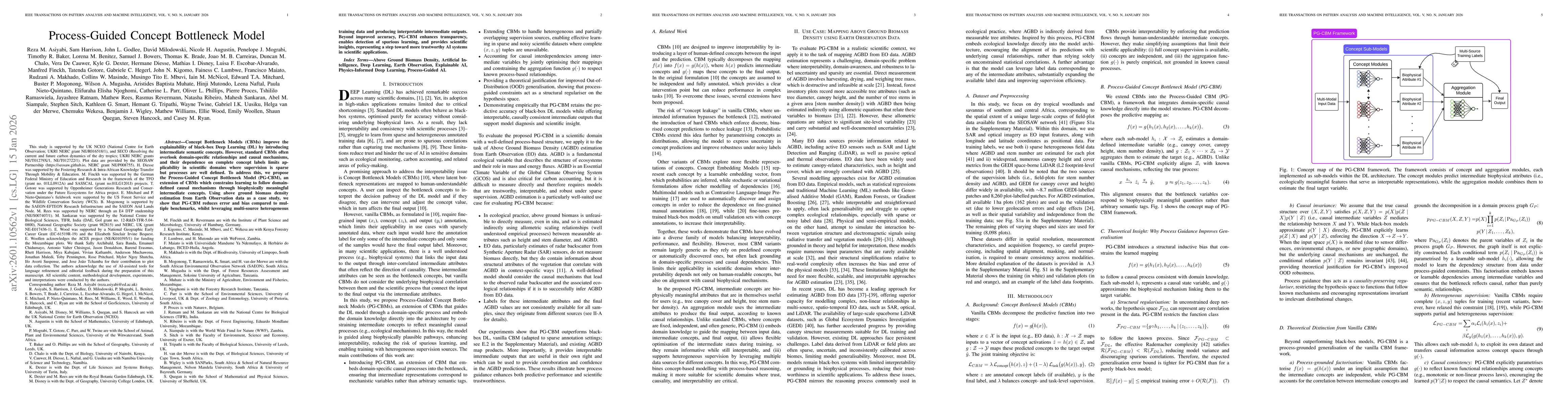
AI Key Findings
Generated Jan 16, 2026
Methodology — What approach did the authors take?
The research employs a hybrid approach combining satellite remote sensing data (SAR and optical imagery) with field-measured plot data to estimate biomass and canopy metrics in tropical ecosystems. It utilizes advanced machine learning models trained on multi-source datasets to improve accuracy and spatial coverage.
Key Results — What are the main findings?
- Achieved high accuracy in estimating canopy height and cover using SAR and optical data fusion
- Demonstrated the effectiveness of field plot data in calibrating and validating remote sensing estimates
- Identified critical spatial and temporal factors influencing biomass estimation accuracy
Significance — Why does this research matter?
This research provides a scalable framework for monitoring forest biomass and ecosystem health, supporting climate change mitigation efforts and sustainable land management. It bridges the gap between remote sensing and ground truth data for improved ecological assessments.
Technical Contribution — What is the technical contribution?
The study introduces a novel data fusion technique that optimizes the complementary strengths of SAR and optical remote sensing, combined with rigorous field validation protocols for enhanced model reliability.
Novelty — What is new about this work?
This work stands out by combining multi-temporal satellite data with standardized field plots in a way that addresses both spatial scalability and measurement accuracy, offering a new paradigm for ecological remote sensing applications.
Limitations — What are the limitations of this study?
- Dependence on high-quality field data which may not be available in all regions
- Potential inaccuracies in SAR data due to atmospheric interference and surface roughness
Future Work — What did the authors propose for future work?
- Integration with drone-based sensing for higher-resolution data collection
- Development of adaptive algorithms for dynamic environmental conditions
- Expansion to include other biometric parameters such as leaf area index
Paper Details
How to Cite This Paper
@article{ryan2026process,
title = {Process-Guided Concept Bottleneck Model},
author = {Ryan, Casey and Asiyabi, Reza M. and Partnership, SEOSAW and others},
year = {2026},
eprint = {2601.10562},
archivePrefix = {arXiv},
primaryClass = {cs.LG},
}
Ryan, C., Asiyabi, R., Partnership, S., & Hancock, S. (2026). Process-Guided Concept Bottleneck Model. arXiv. https://arxiv.org/abs/2601.10562
Ryan, Casey, et al. "Process-Guided Concept Bottleneck Model." arXiv, 2026, arxiv.org/abs/2601.10562.
PDF Preview
Similar Papers
Found 4 papersGraph Integrated Multimodal Concept Bottleneck Model
Jiakai Lin, Jinchang Zhang, Guoyu Lu
Comments (0)