RESOLVE: A Multi-Resolution and Multi-Modal Dataset for Roadside Cooperative Perception
Publication
Metrics
Paper Preview
Abstract
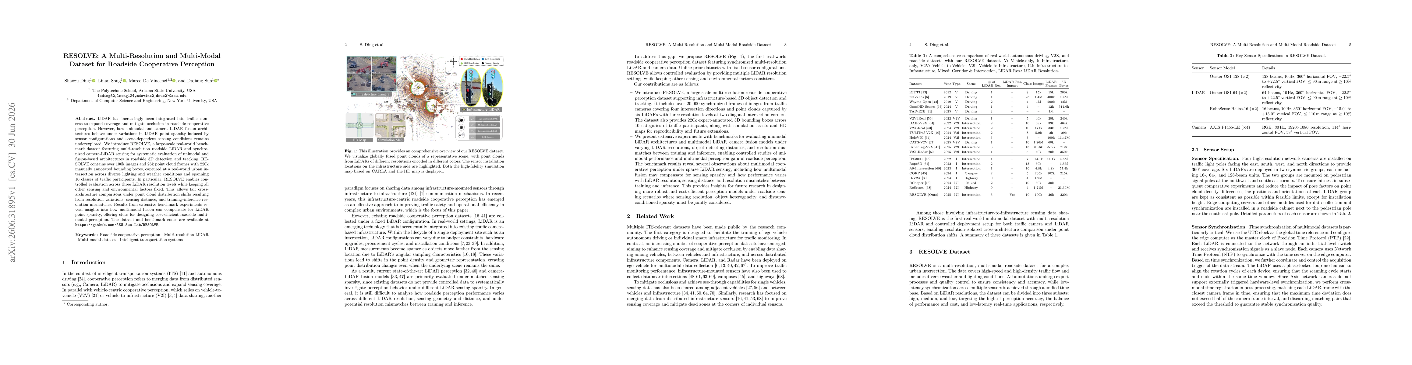
LiDAR has increasingly been integrated into traffic cameras to expand coverage and mitigate occlusion in roadside cooperative perception. However, how unimodal and camera-LiDAR fusion architectures behave under variations in LiDAR point sparsity induced by sensor configurations and scene-dependent sensing conditions remains underexplored. We introduce RESOLVE, a large-scale real-world benchmark dataset featuring multi-resolution roadside LiDAR and synchronized camera-LiDAR sensing for systematic evaluation of unimodal and fusion-based architectures in roadside 3D detection and tracking. RESOLVE contains over 100k images and 26k point cloud frames with 220k manually annotated bounding boxes, captured at a real-world urban intersection across diverse lighting and weather conditions and spanning 10 classes of traffic participants. In particular, RESOLVE enables controlled evaluation across three LiDAR resolution levels while keeping all other sensing and environmental factors fixed. This allows fair cross-architecture comparisons under point cloud distribution shifts resulting from resolution variations, sensing distance, and training-inference resolution mismatches. Results from extensive benchmark experiments reveal insights into how multimodal fusion can compensate for LiDAR point sparsity, offering clues for designing cost-efficient roadside multimodal perception. The dataset and benchmark codes are available at https://github.com/ASU-Suo-Lab/RESOLVE.
AI Key Findings
Get AI-generated insights about this paper's methodology, results, significance, and more — seven facets brought into focus.
Discussion 0