SatMap integrates satellite maps with multi-view camera observations to predict vectorized HD maps. It uses BEV feature extraction from both camera and satellite data, followed by multi-modal fusion with a ConvFuser module. A DETR-based transformer decoder predicts map elements from fused BEV features.
SatMap: Revisiting Satellite Maps as Prior for Online HD Map Construction
Publication
Metrics
Quick Answers
What methodology did the authors use?
SatMap integrates satellite maps with multi-view camera observations to predict vectorized HD maps. It uses BEV feature extraction from both camera and satellite data, followed by multi-modal fusion with a ConvFuser module. A DETR-based transformer decoder predicts map elements from fused BEV features. More in Methodology →
What are the key results?
SatMap achieves 34.8% mAP improvement over camera-only baseline and 8.5% mAP improvement over camera-LiDAR fusion baseline on nuScenes dataset — SatMap outperforms existing methods like GeMap, StreamMapNet, MGMap, and HIMap in vectorized map prediction More in Key Results →
Why is this work significant?
This research enhances online HD map construction for autonomous driving by leveraging satellite maps as a global prior, improving accuracy and robustness in occluded scenarios and adverse conditions. More in Significance →
What are the main limitations?
SatMap is a single-frame framework without temporal information — Performance degradation in rainy weather due to camera limitations More in Limitations →
Abstract
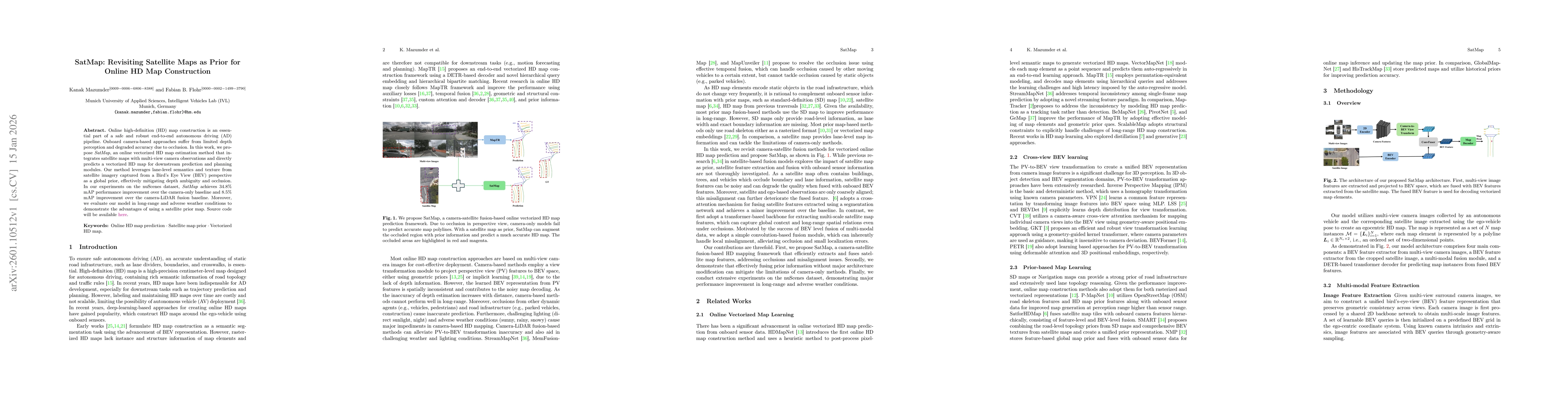
Online high-definition (HD) map construction is an essential part of a safe and robust end-to-end autonomous driving (AD) pipeline. Onboard camera-based approaches suffer from limited depth perception and degraded accuracy due to occlusion. In this work, we propose SatMap, an online vectorized HD map estimation method that integrates satellite maps with multi-view camera observations and directly predicts a vectorized HD map for downstream prediction and planning modules. Our method leverages lane-level semantics and texture from satellite imagery captured from a Bird's Eye View (BEV) perspective as a global prior, effectively mitigating depth ambiguity and occlusion. In our experiments on the nuScenes dataset, SatMap achieves 34.8% mAP performance improvement over the camera-only baseline and 8.5% mAP improvement over the camera-LiDAR fusion baseline. Moreover, we evaluate our model in long-range and adverse weather conditions to demonstrate the advantages of using a satellite prior map. Source code will be available at https://iv.ee.hm.edu/satmap/.
Key Findings, in focus
Seven facets of this paper, analysed and brought into focus by AI.
This research enhances online HD map construction for autonomous driving by leveraging satellite maps as a global prior, improving accuracy and robustness in occluded scenarios and adverse conditions.
- SatMap achieves 34.8% mAP improvement over camera-only baseline and 8.5% mAP improvement over camera-LiDAR fusion baseline on nuScenes dataset
- SatMap outperforms existing methods like GeMap, StreamMapNet, MGMap, and HIMap in vectorized map prediction
- The model demonstrates robustness in long-range and adverse weather conditions
This research enhances online HD map construction for autonomous driving by leveraging satellite maps as a global prior, improving accuracy and robustness in occluded scenarios and adverse conditions.
Proposes a novel multi-modal fusion approach combining satellite and camera data in BEV space for vectorized HD map prediction
Uses satellite imagery as a global prior for BEV map prediction, leveraging geometry-guided kernels and multi-scale feature fusion for improved accuracy and robustness
- SatMap is a single-frame framework without temporal information
- Performance degradation in rainy weather due to camera limitations
- Incorporate temporal information for better dynamic scene understanding
- Improve robustness in adverse weather conditions through enhanced sensor fusion
Discussion 0