Authors
Publication
Metrics
Quick Actions
Quick Answers
What methodology did the authors use?
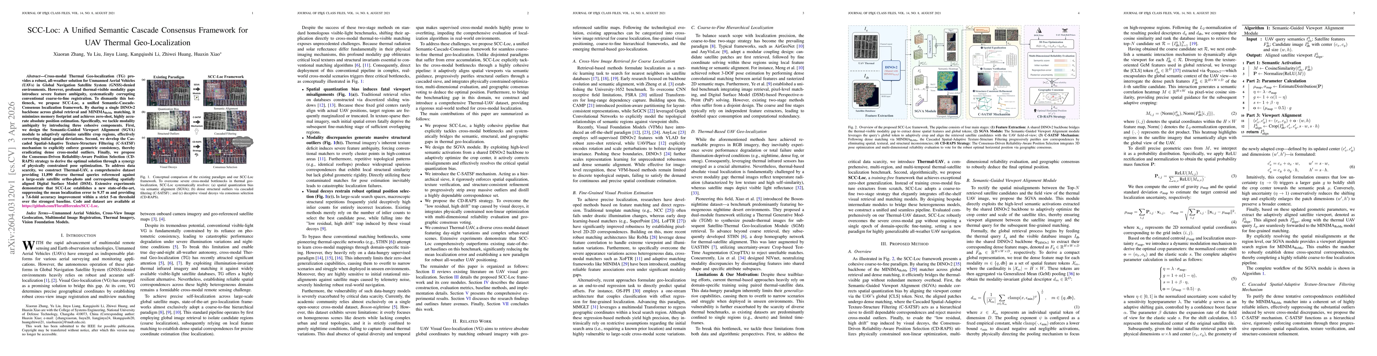
Two-stage pipeline using a shared DINOv2 backbone for retrieval and MINIMARoMa matching, followed by semantic viewport alignment (SGVA), cascaded spatial-adaptive texture-structure filtering (C-SATSF), and consensus-driven reliability-aware pose selection (CD-RAPS) with physical constraints. More in Methodology →
What are the key results?
Achieved state-of-the-art mean localization error of 9.37 m and Acc@5 of 52.09 % on the Thermal-UAV dataset, a 7.6× improvement over the strongest baseline. — Cascaded filtering and consensus selection reduced outlier rates, enabling robust pose estimation even under severe thermal-visible modality gaps. More in Key Results →
Why is this work significant?
Provides a robust, all-weather UAV geo-localization solution in GNSS-denied environments by bridging the thermal-visible modality gap, and introduces a comprehensive Thermal-UAV benchmark for future research. More in Significance →
What are the main limitations?
Relies on manually tuned hyper-parameters, making initialization complex. — Sensitive to inaccurate telemetry priors (pitch/yaw) which can degrade performance. More in Limitations →
Paper Preview
Abstract
Cross-modal Thermal Geo-localization (TG) provides a robust, all-weather solution for Unmanned Aerial Vehicles (UAVs) in Global Navigation Satellite System (GNSS)-denied environments. However, profound thermal-visible modality gaps introduce severe feature ambiguity, systematically corrupting conventional coarse-to-fine registration. To dismantle this bottleneck, we propose SCC-Loc, a unified Semantic-Cascade-Consensus localization framework. By sharing a single DINOv2 backbone across global retrieval and MINIMA$_{\text{RoMa}}$ matching, it minimizes memory footprint and achieves zero-shot, highly accurate absolute position estimation. Specifically, we tackle modality ambiguity by introducing three cohesive components. First, we design the Semantic-Guided Viewport Alignment (SGVA) module to adaptively optimize satellite crop regions, effectively correcting initial spatial deviations. Second, we develop the Cascaded Spatial-Adaptive Texture-Structure Filtering (C-SATSF) mechanism to explicitly enforce geometric consistency, thereby eradicating dense cross-modal outliers. Finally, we propose the Consensus-Driven Reliability-Aware Position Selection (CD-RAPS) strategy to derive the optimal solution through a synergy of physically constrained pose optimization. To address data scarcity, we construct Thermal-UAV, a comprehensive dataset providing 11,890 diverse thermal queries referenced against a large-scale satellite ortho-photo and corresponding spatially aligned Digital Surface Model (DSM). Extensive experiments demonstrate that SCC-Loc establishes a new state-of-the-art, suppressing the mean localization error to 9.37 m and providing a 7.6-fold accuracy improvement within a strict 5-m threshold over the strongest baseline. Code and dataset are available at https://github.com/FloralHercules/SCC-Loc.
AI Key Findings
Generated Apr 06, 2026
Methodology — What approach did the authors take?
Two-stage pipeline using a shared DINOv2 backbone for retrieval and MINIMARoMa matching, followed by semantic viewport alignment (SGVA), cascaded spatial-adaptive texture-structure filtering (C-SATSF), and consensus-driven reliability-aware pose selection (CD-RAPS) with physical constraints.
Key Results — What are the main findings?
- Achieved state-of-the-art mean localization error of 9.37 m and Acc@5 of 52.09 % on the Thermal-UAV dataset, a 7.6× improvement over the strongest baseline.
- Cascaded filtering and consensus selection reduced outlier rates, enabling robust pose estimation even under severe thermal-visible modality gaps.
- Unified architecture reduced GPU memory to 1.17 GB and maintained a practical inference time of 7.5 s per query.
Significance — Why does this research matter?
Provides a robust, all-weather UAV geo-localization solution in GNSS-denied environments by bridging the thermal-visible modality gap, and introduces a comprehensive Thermal-UAV benchmark for future research.
Technical Contribution — What is the technical contribution?
A unified semantic cascade consensus framework that integrates semantic viewport alignment, spatial-adaptive filtering, and physically constrained pose optimization to achieve zero-shot, highly accurate cross-modal UAV geo-localization.
Novelty — What is new about this work?
First to combine a single backbone for retrieval and matching with semantic alignment, cascaded filtering, and consensus-driven reliability selection in a zero-shot cross-modal setting, setting new performance and efficiency benchmarks.
Limitations — What are the limitations of this study?
- Relies on manually tuned hyper-parameters, making initialization complex.
- Sensitive to inaccurate telemetry priors (pitch/yaw) which can degrade performance.
Future Work — What did the authors propose for future work?
- Develop an end-to-end trainable framework that learns thresholds and compensates for attitude variations automatically.
- Optimize the pipeline for real-time edge deployment by reducing inference latency and simplifying the multi-stage filtering.
Paper Details
How to Cite This Paper
@article{xiao2026scc,
  title         = {SCC-Loc: A Unified Semantic Cascade Consensus Framework for UAV Thermal Geo-Localization},
  author        = {Xiao, Huaxin and Liang, Jinyu and Li, Kangqiushi and others},
  year          = {2026},
  eprint        = {2604.03120},
  archivePrefix = {arXiv},
  primaryClass  = {cs.CV},
}Xiao, H., Liang, J., Li, K., Zhang, X., Liu, Y., & Huang, Z. (2026). SCC-Loc: A Unified Semantic Cascade Consensus Framework for UAV Thermal Geo-Localization. arXiv. https://arxiv.org/abs/2604.03120Xiao, Huaxin, et al. "SCC-Loc: A Unified Semantic Cascade Consensus Framework for UAV Thermal Geo-Localization." arXiv, 2026, arxiv.org/abs/2604.03120.PDF Preview
Similar Papers
Found 4 papersA Transformer-Based Adaptive Semantic Aggregation Method for UAV Visual Geo-Localization
Shishen Li, Cuiwei Liu, Huaijun Qiu et al.
Long-range UAV Thermal Geo-localization with Satellite Imagery
Jiuhong Xiao, Daniel Tortei, Eloy Roura et al.
UASTHN: Uncertainty-Aware Deep Homography Estimation for UAV Satellite-Thermal Geo-localization
Jiuhong Xiao, Giuseppe Loianno
STHN: Deep Homography Estimation for UAV Thermal Geo-localization with Satellite Imagery
Jiuhong Xiao, Giuseppe Loianno, Ning Zhang et al.
Comments (0)