Publication

Published: Oct 23, 2025
Categories: cs.CV

Metrics

Source: ArXiv

Quick Actions

View PDF

Quick Answers

What methodology did the authors use?

The research proposes EDGeo, a cross-view object geo-localization method that integrates mask-based positional encoding and a context enhancement module. It utilizes satellite and ground view images, employs attention mechanisms for feature extraction, and validates results through extensive experiments on benchmark datasets. More in Methodology →

What are the key results?

EDGeo achieves state-of-the-art performance in cross-view geo-localization tasks. — The mask-based positional encoding improves model robustness to object marking point variations. More in Key Results →

Why is this work significant?

This research advances cross-view geo-localization by providing a robust and accurate method for identifying objects across different viewpoints, which has critical applications in disaster response, autonomous navigation, and remote sensing. More in Significance →

What are the main limitations?

Current image segmentation models still have segmentation errors that affect model robustness. — The method's performance may be limited in scenarios with extreme viewpoint differences or occlusions. More in Limitations →

Paper Preview

Abstract

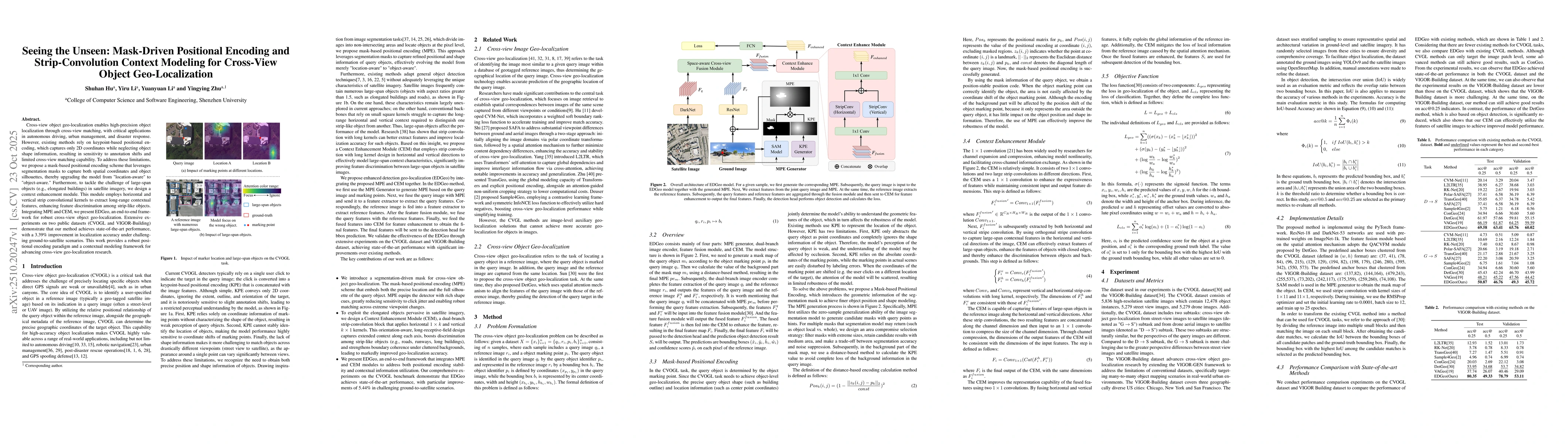
Cross-view object geo-localization enables high-precision object localization through cross-view matching, with critical applications in autonomous driving, urban management, and disaster response. However, existing methods rely on keypoint-based positional encoding, which captures only 2D coordinates while neglecting object shape information, resulting in sensitivity to annotation shifts and limited cross-view matching capability. To address these limitations, we propose a mask-based positional encoding scheme that leverages segmentation masks to capture both spatial coordinates and object silhouettes, thereby upgrading the model from "location-aware" to "object-aware." Furthermore, to tackle the challenge of large-span objects (e.g., elongated buildings) in satellite imagery, we design a context enhancement module. This module employs horizontal and vertical strip convolutional kernels to extract long-range contextual features, enhancing feature discrimination among strip-like objects. Integrating MPE and CEM, we present EDGeo, an end-to-end framework for robust cross-view object geo-localization. Extensive experiments on two public datasets (CVOGL and VIGOR-Building) demonstrate that our method achieves state-of-the-art performance, with a 3.39% improvement in localization accuracy under challenging ground-to-satellite scenarios. This work provides a robust positional encoding paradigm and a contextual modeling framework for advancing cross-view geo-localization research.

AI Key Findings

Generated Oct 25, 2025

Methodology — What approach did the authors take?

The research proposes EDGeo, a cross-view object geo-localization method that integrates mask-based positional encoding and a context enhancement module. It utilizes satellite and ground view images, employs attention mechanisms for feature extraction, and validates results through extensive experiments on benchmark datasets.

Key Results — What are the main findings?

  • EDGeo achieves state-of-the-art performance in cross-view geo-localization tasks.
  • The mask-based positional encoding improves model robustness to object marking point variations.
  • The context enhancement module effectively leverages global reference image information to enhance feature aggregation for better object detection.

Significance — Why does this research matter?

This research advances cross-view geo-localization by providing a robust and accurate method for identifying objects across different viewpoints, which has critical applications in disaster response, autonomous navigation, and remote sensing.

Technical Contribution — What is the technical contribution?

The paper introduces a novel mask-based positional encoding technique and a context enhancement module that effectively combines global reference information with local query features for improved geo-localization accuracy.

Novelty — What is new about this work?

EDGeo introduces a mask-based positional encoding approach that outperforms traditional keypoint-based methods, combined with a context enhancement module that leverages global reference image information for more accurate cross-view object localization.

Limitations — What are the limitations of this study?

  • Current image segmentation models still have segmentation errors that affect model robustness.
  • The method's performance may be limited in scenarios with extreme viewpoint differences or occlusions.

Future Work — What did the authors propose for future work?

  • Improving segmentation accuracy through better segmentation models.
  • Exploring more robust attention mechanisms for handling extreme viewpoint variations.
  • Expanding the method to handle more complex and diverse geo-localization scenarios.

Paper Details

Paper ID: 2510.20247
Categories:
cs.CV

How to Cite This Paper

BibTeX
@article{hu2025seeing,
  title         = {Seeing the Unseen: Mask-Driven Positional Encoding and Strip-Convolution
  Context Modeling for Cross-View Object Geo-Localization},
  author        = {Hu, Shuhan and Zhu, Yingying and Li, Yiru and others},
  year          = {2025},
  eprint        = {2510.20247},
  archivePrefix = {arXiv},
  primaryClass  = {cs.CV},
}
APA 7
Hu, S., Zhu, Y., Li, Y., & Li, Y. (2025). Seeing the Unseen: Mask-Driven Positional Encoding and Strip-Convolution
  Context Modeling for Cross-View Object Geo-Localization. arXiv. https://arxiv.org/abs/2510.20247
MLA 9
Hu, Shuhan, et al. "Seeing the Unseen: Mask-Driven Positional Encoding and Strip-Convolution
  Context Modeling for Cross-View Object Geo-Localization." arXiv, 2025, arxiv.org/abs/2510.20247.

Similar Papers

Found 4 papers

Comments (0)

This website uses cookies to ensure you get the best experience. Learn more