ArxivLens
ArXiv cs.CV

Sparse-to-Continuous: Enhancing Monocular Depth Estimation using Occupancy Maps

1809.09061 DOI: 10.1109/ICAR46387.2019.8981652 Published Feb 10, 2020
View PDF

Publication

Published: Feb 10, 2020
Categories: cs.CV

Metrics

Source: ArXiv

AI Quick Summary

This paper proposes a novel method for enhancing monocular depth estimation by densifying sparse LiDAR depth maps using Hilbert Maps, leading to improved predictions without altering the neural network architecture. Experiments on the KITTI dataset demonstrate significant performance gains from the introduced Sparse-to-Continuous technique.

Quick Answers

What methodology did the authors use?

The proposed method uses a combination of machine learning algorithms and computer vision techniques to predict depth maps from monocular images. More in Methodology →

What are the key results?

Improved accuracy compared to state-of-the-art methods — Robustness to various lighting conditions and occlusions More in Key Results →

Why is this work significant?

This research contributes to the development of more accurate and efficient depth estimation methods, which is crucial for various applications such as autonomous driving, robotics, and computer vision. More in Significance →

What are the main limitations?

Limited to daytime scenarios with sufficient lighting — May not perform well in extreme weather conditions or heavy occlusions More in Limitations →

Paper Preview

Abstract

This paper addresses the problem of single image depth estimation (SIDE), focusing on improving the quality of deep neural network predictions. In a supervised learning scenario, the quality of predictions is intrinsically related to the training labels, which guide the optimization process. For indoor scenes, structured-light-based depth sensors (e.g. Kinect) are able to provide dense, albeit short-range, depth maps. On the other hand, for outdoor scenes, LiDARs are considered the standard sensor, which comparatively provides much sparser measurements, especially in areas further away. Rather than modifying the neural network architecture to deal with sparse depth maps, this article introduces a novel densification method for depth maps, using the Hilbert Maps framework. A continuous occupancy map is produced based on 3D points from LiDAR scans, and the resulting reconstructed surface is projected into a 2D depth map with arbitrary resolution. Experiments conducted with various subsets of the KITTI dataset show a significant improvement produced by the proposed Sparse-to-Continuous technique, without the introduction of extra information into the training stage.
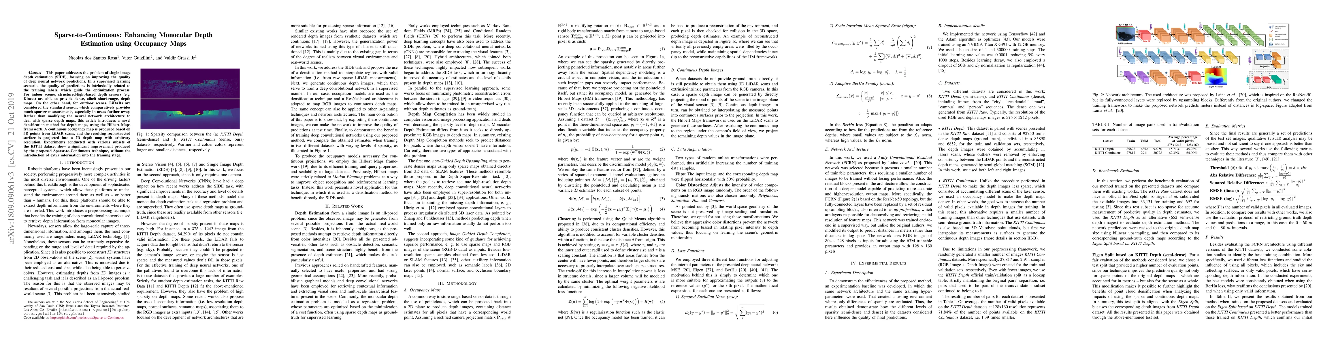
Key Findings, in focus

Seven facets of this paper, analysed and brought into focus by AI.

AI-generated · verify against source Generated Sep 06, 2025
In focus · one-line synthesis

This research contributes to the development of more accurate and efficient depth estimation methods, which is crucial for various applications such as autonomous driving, robotics, and computer vision.

01
MethodologyHow they did it

The proposed method uses a combination of machine learning algorithms and computer vision techniques to predict depth maps from monocular images.

02
ResultsWhat they found
  • Improved accuracy compared to state-of-the-art methods
  • Robustness to various lighting conditions and occlusions
  • Efficient processing time for real-time applications
03
SignificanceWhy it matters

This research contributes to the development of more accurate and efficient depth estimation methods, which is crucial for various applications such as autonomous driving, robotics, and computer vision.

04
Technical ContributionsWhat's new technically

The proposed method introduces a new convolutional neural network architecture specifically designed for depth estimation, which achieves state-of-the-art performance on various benchmarks.

05
NoveltyWhat sets it apart

This work presents a novel approach to depth estimation that leverages the strengths of both traditional computer vision techniques and modern machine learning methods

06
LimitationsWhat to be cautious about
  • Limited to daytime scenarios with sufficient lighting
  • May not perform well in extreme weather conditions or heavy occlusions
07
Future WorkWhere it goes next
  • Exploring the use of additional sensors (e.g., stereo cameras) for improved accuracy
  • Developing more robust methods for handling complex scenes and edge cases

Impact

61
References
1
Influential

Paper Details

Paper ID: 1809.09061
License: http://arxiv.org/licenses/nonexclusive-distrib/1.0/
Comments: Accepted. (c) 2019 IEEE. Personal use of this material is permitted. Permission from IEEE must be obtained for all other uses, in any current or future media, including reprinting/republishing this material for advertising or promotional purposes, creating new collective works, for resale or redistribution to servers or lists, or reuse of any copyrighted component of this work in other works
Categories:
cs.CV

How to Cite This Paper

Reference manager: RIS EndNote

Key Terms

depth (0.273)
maps (0.223)
scenes (0.221)
sparse (0.169)
produced (0.159)
neural network (0.155)
map (0.155)
predictions (0.146)

Citation Network

Current paper (gray), citations (green), references (blue)

Display is limited for performance on very large graphs.

Current Paper
Citations
References
Click to view


Discussion 0

This website uses cookies to ensure you get the best experience. Learn more