Using construction waste hauling trucks' GPS data to classify earthwork-related locations: A Chengdu case study
Publication
Metrics
AI Quick Summary
This paper proposes a method to classify earthwork-related locations (ERLs) in Chengdu using GPS data from construction waste hauling trucks, achieving 77.8% accuracy. The framework identified 724 construction sites and other ERLs, aiding in the management of urban dust pollution.
Paper Preview
Abstract
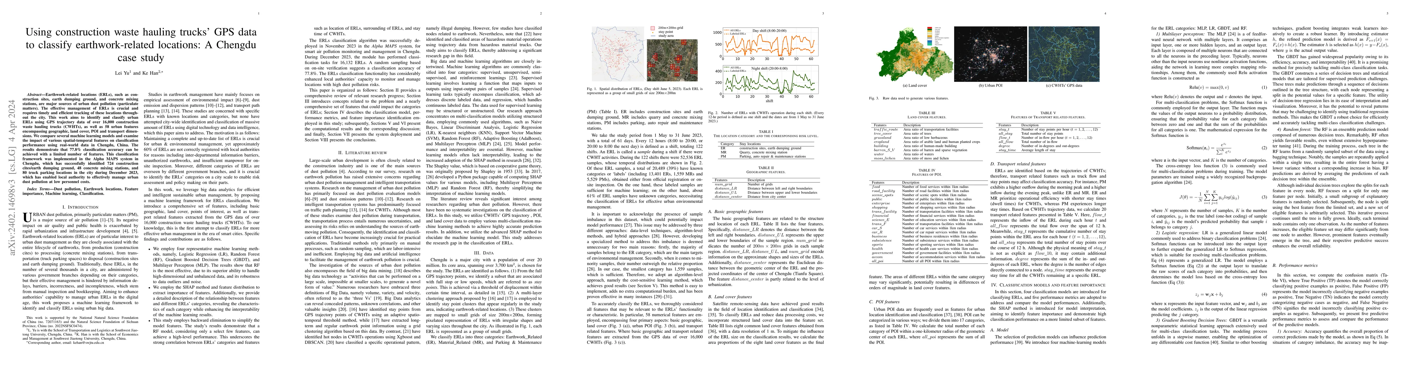
Earthwork-related locations (ERLs), such as construction sites, earth dumping ground, and concrete mixing stations, are major sources of urban dust pollution (particulate matters). The effective management of ERLs is crucial and requires timely and efficient tracking of these locations throughout the city. This work aims to identify and classify urban ERLs using GPS trajectory data of over 16,000 construction waste hauling trucks (CWHTs), as well as 58 urban features encompassing geographic, land cover, POI and transport dimensions. We compare several machine learning models and examine the impact of various spatial-temporal features on classification performance using real-world data in Chengdu, China. The results demonstrate that 77.8% classification accuracy can be achieved with a limited number of features. This classification framework was implemented in the Alpha MAPS system in Chengdu, which has successfully identified 724 construction cites/earth dumping ground, 48 concrete mixing stations, and 80 truck parking locations in the city during December 2023, which has enabled local authority to effectively manage urban dust pollution at low personnel costs.
AI Key Findings
Get AI-generated insights about this paper's methodology, results, significance, and more — seven facets brought into focus.
Impact
Paper Details
Authors
PDF Preview
Key Terms
Citation Network
Current paper (gray), citations (green), references (blue)
Display is limited for performance on very large graphs.
Discussion 0