ArxivLens
A
Researcher

Atal Tewari

5 papers on arXiv

5 arXiv Papers
5 Total Publications
Profile

Academic Profile

Name Atal Tewari
Total Papers 5
Scholar Profile View on Semantic Scholar
Metrics

Statistics

5 arXiv Papers
5 Total Publications
Publications

Papers on arXiv

Thumbnail for Arbitrary Scale Super-Resolution Assisted Lunar Crater Detection in
  Satellite Images
arXiv
Arbitrary Scale Super-Resolution Assisted Lunar Crater Detection in Satellite Images

Craters are one of the most studied planetary features used for different scientific analyses, such as estimation of surface age and surface processes. Satellite images utilized for crater detection...

Thumbnail for Deep Learning based Systems for Crater Detection: A Review
arXiv
Deep Learning based Systems for Crater Detection: A Review

Craters are one of the most prominent features on planetary surfaces, used in applications such as age estimation, hazard detection, and spacecraft navigation. Crater detection is a challenging prob...

Thumbnail for Automatic Crater Shape Retrieval using Unsupervised and Semi-Supervised
  Systems
arXiv
Automatic Crater Shape Retrieval using Unsupervised and Semi-Supervised Systems

Impact craters are formed due to continuous impacts on the surface of planetary bodies. Most recent deep learning-based crater detection methods treat craters as circular shapes, and less attention ...

Thumbnail for In-Orbit Lunar Satellite Image Super Resolution for Selective Data
  Transmission
arXiv
In-Orbit Lunar Satellite Image Super Resolution for Selective Data Transmission

Rapid technological advancements have tremendously increased the data acquisition capabilities of remote sensing satellites. However, the data utilization efficiency in satellite missions is very lo...

Thumbnail for Automated Crater Detection from Co-registered Optical Images, Elevation
  Maps and Slope Maps using Deep Learning
arXiv
Automated Crater Detection from Co-registered Optical Images, Elevation Maps and Slope Maps using Deep Learning

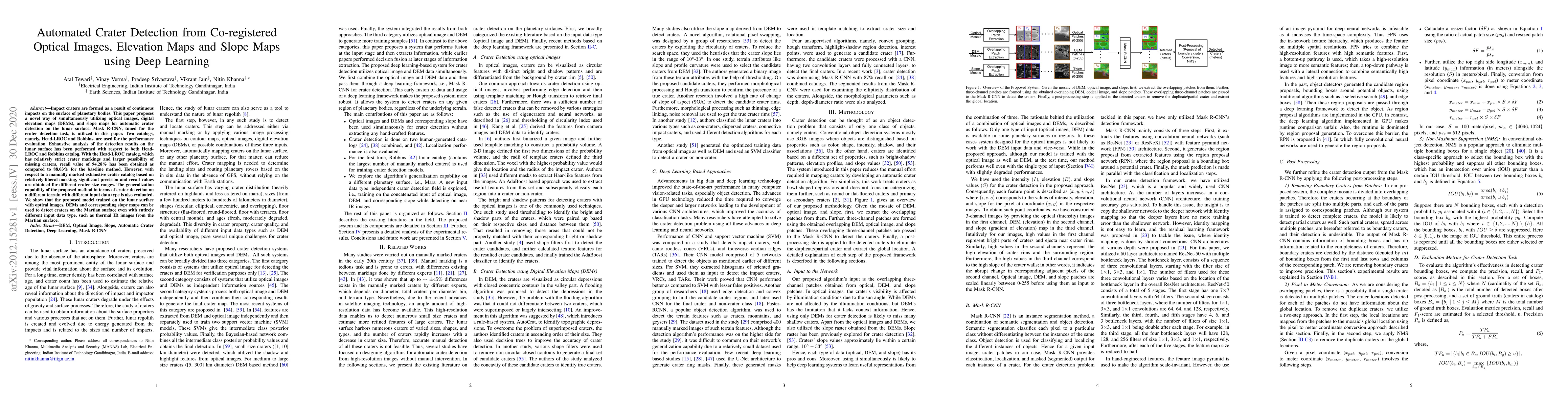
Impact craters are formed as a result of continuous impacts on the surface of planetary bodies. This paper proposes a novel way of simultaneously utilizing optical images, digital elevation maps (DE...

This website uses cookies to ensure you get the best experience. Learn more