Automated Crater Detection from Co-registered Optical Images, Elevation Maps and Slope Maps using Deep Learning
Publication
Metrics
Paper Preview
Abstract
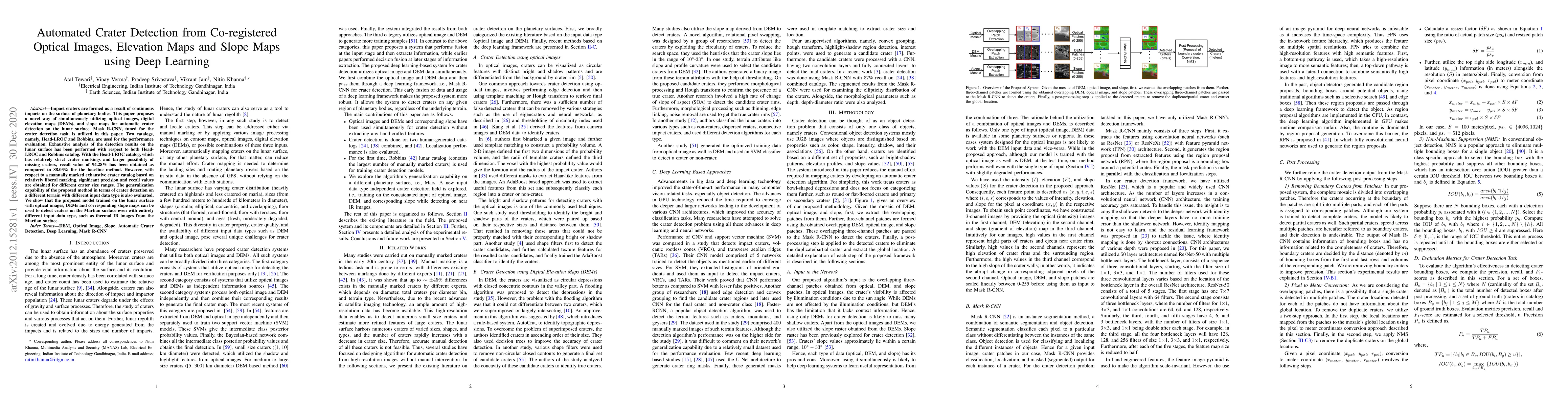
Impact craters are formed as a result of continuous impacts on the surface of planetary bodies. This paper proposes a novel way of simultaneously utilizing optical images, digital elevation maps (DEMs), and slope maps for automatic crater detection on the lunar surface. Mask R-CNN, tuned for the crater detection task, is utilized in this paper. Two catalogs, namely, Head-LROC and Robbins, are used for the performance evaluation. Exhaustive analysis of the detection results on the lunar surface has been performed with respect to both Head-LROC and Robbins catalog. With the Head-LROC catalog, which has relatively strict crater markings and larger possibility of missing craters, recall value of 94.28\% has been obtained as compared to 88.03\% for the baseline method. However, with respect to a manually marked exhaustive crater catalog based on relatively liberal marking, significant precision and recall values are obtained for different crater size ranges. The generalization capability of the proposed method in terms of crater detection on a different terrain with different input data type is also evaluated. We show that the proposed model trained on the lunar surface with optical images, DEMs and corresponding slope maps can be used to detect craters on the Martian surface even with entirely different input data type, such as thermal IR images from the Martian surface.
AI Key Findings
Get AI-generated insights about this paper's methodology, results, significance, and more — seven facets brought into focus.
Impact
Paper Details
Authors
PDF Preview
Key Terms
Citation Network
Current paper (gray), citations (green), references (blue)
Display is limited for performance on very large graphs.
Discussion 0