Academic Profile
Statistics
Similar Authors
Papers on arXiv
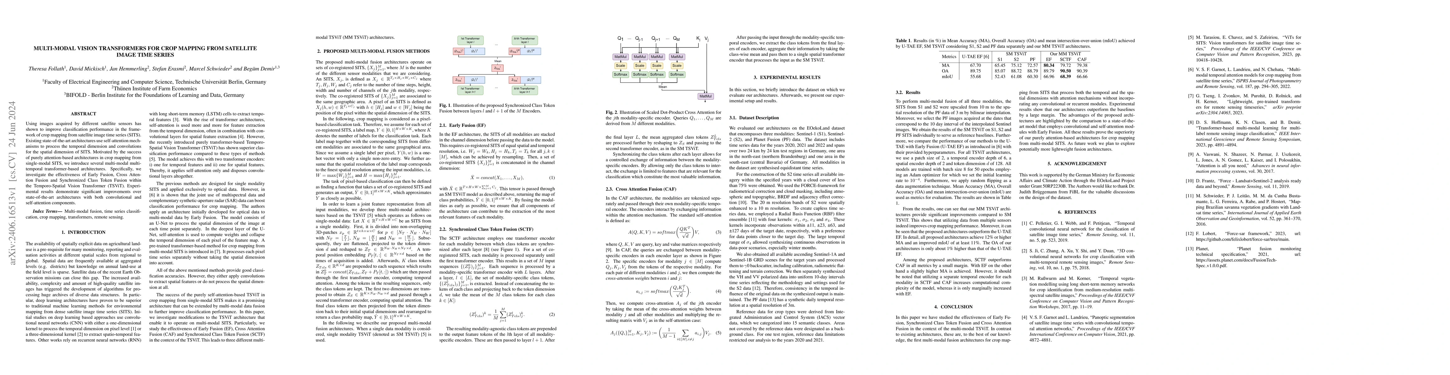
Using images acquired by different satellite sensors has shown to improve classification performance in the framework of crop mapping from satellite image time series (SITS). Existing state-of-the-art...
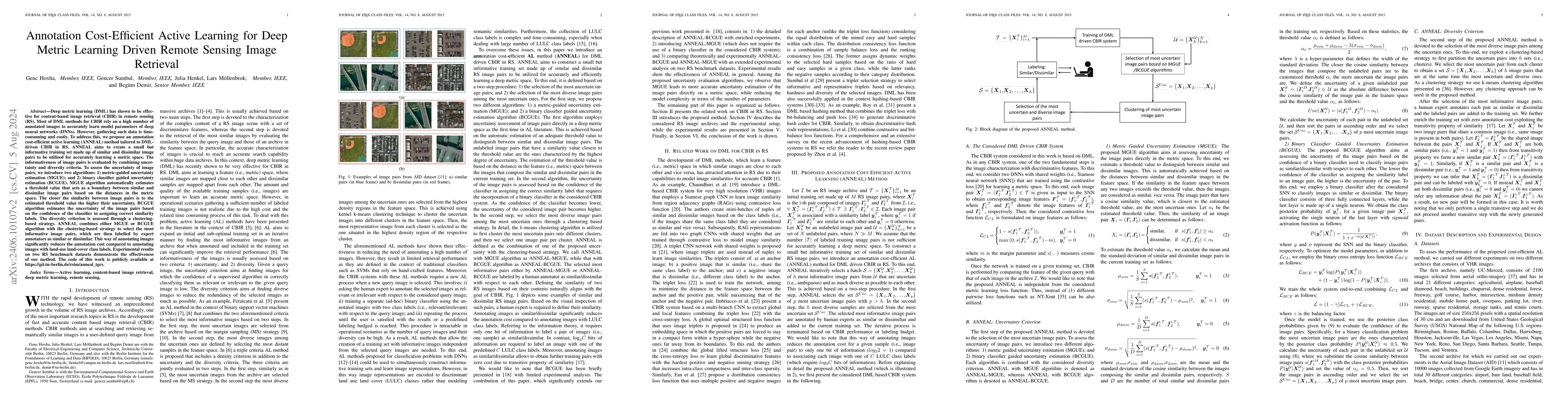
Deep metric learning (DML) has shown to be very effective for content-based image retrieval (CBIR) in remote sensing (RS). Most of DML methods for CBIR rely on many annotated images to accurately le...
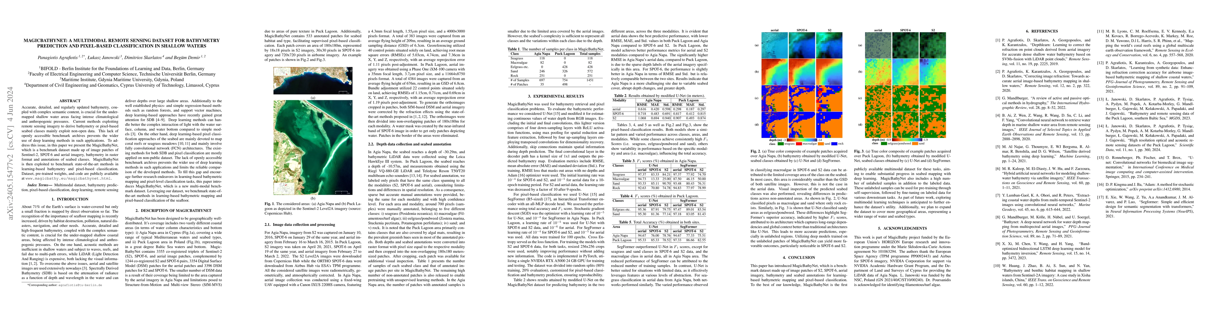
Accurate, detailed, and high-frequent bathymetry, coupled with complex semantic content, is crucial for the undermapped shallow seabed areas facing intense climatological and anthropogenic pressures...
Federated learning (FL) aims to collaboratively learn deep learning model parameters from decentralized data archives (i.e., clients) without accessing training data on clients. However, the trainin...
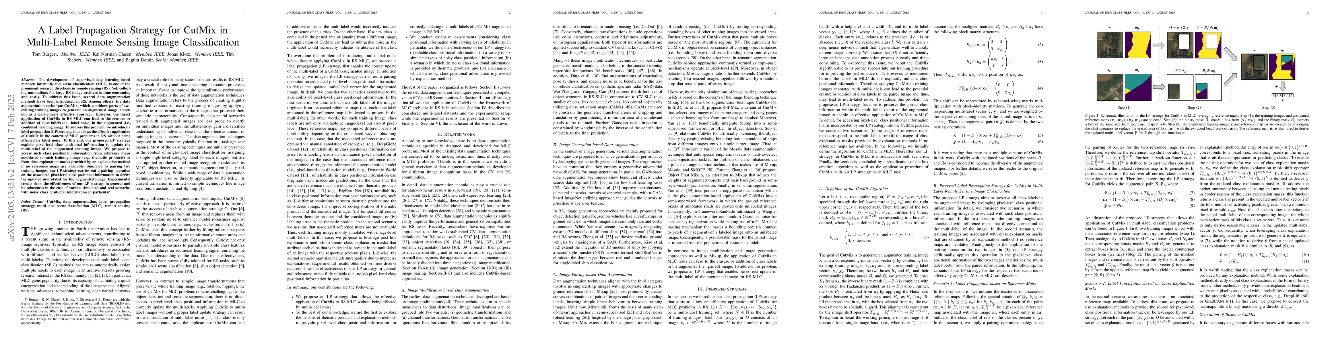
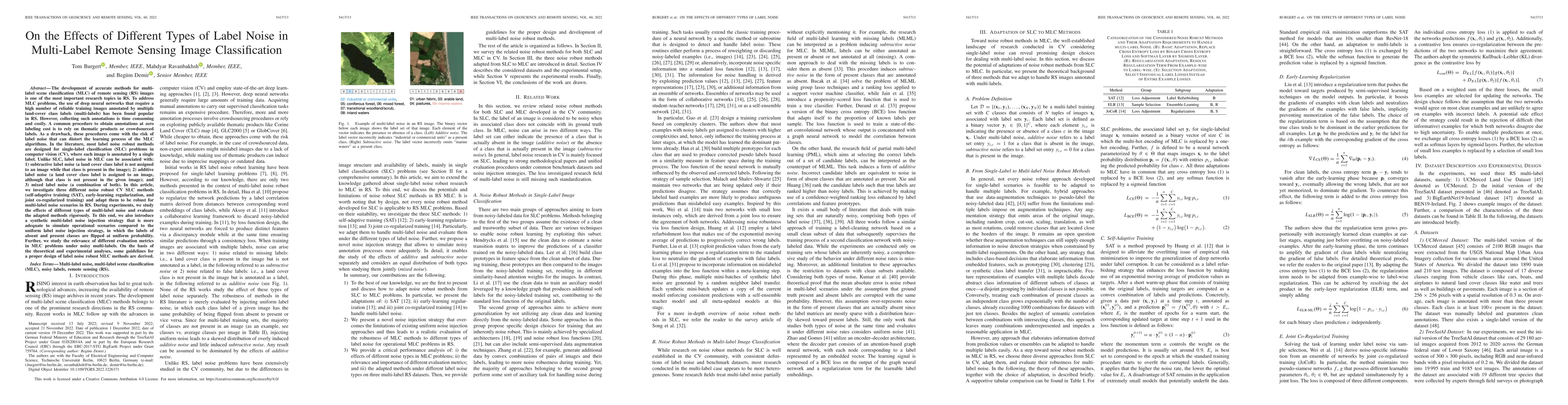
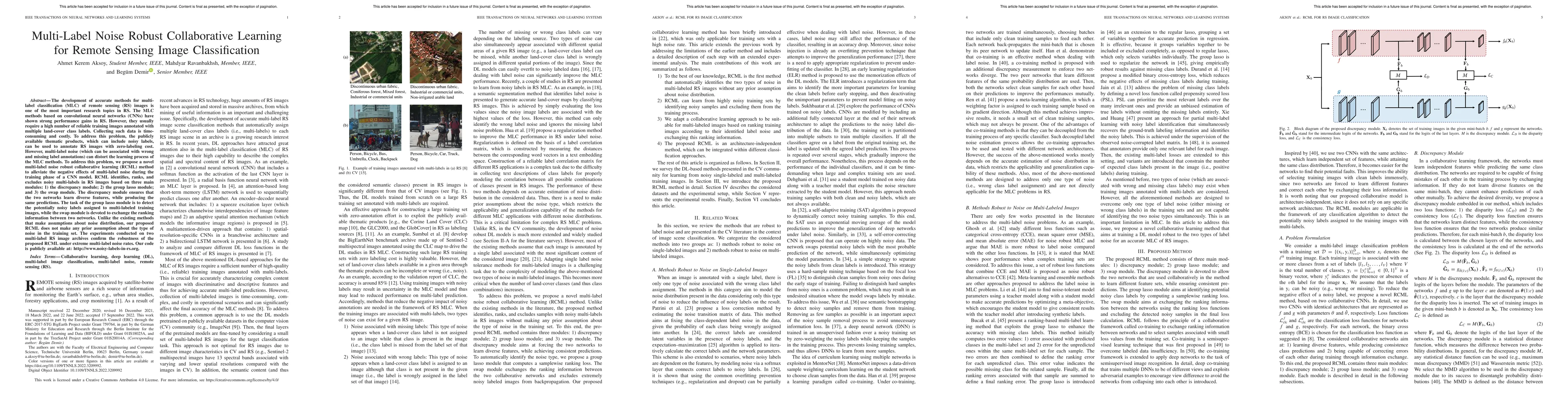
The development of supervised deep learning-based methods for multi-label scene classification (MLC) is one of the prominent research directions in remote sensing (RS). Yet, collecting annotations f...
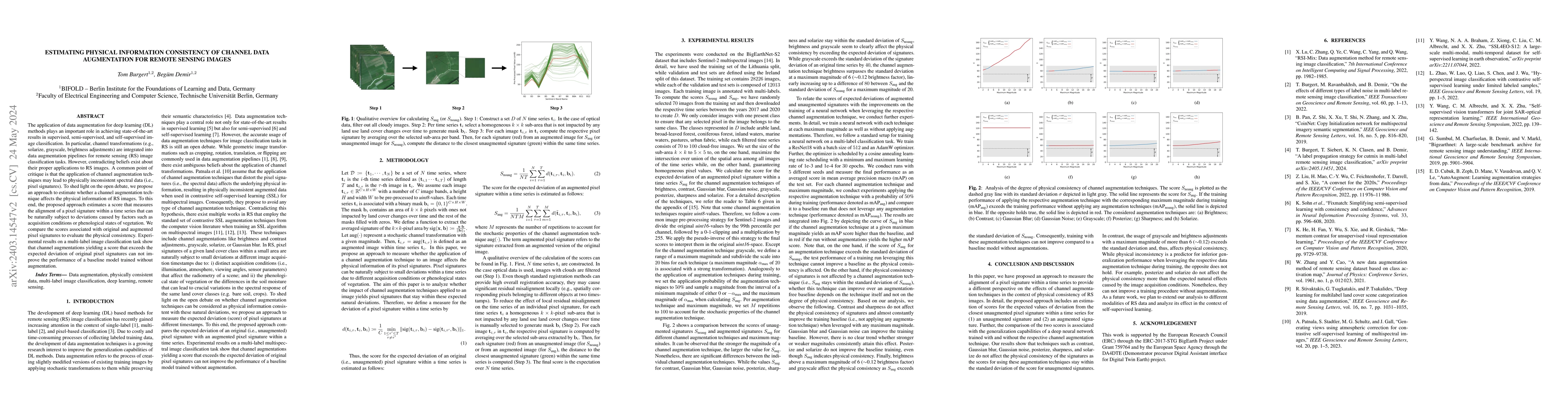
The application of data augmentation for deep learning (DL) methods plays an important role in achieving state-of-the-art results in supervised, semi-supervised, and self-supervised image classifica...
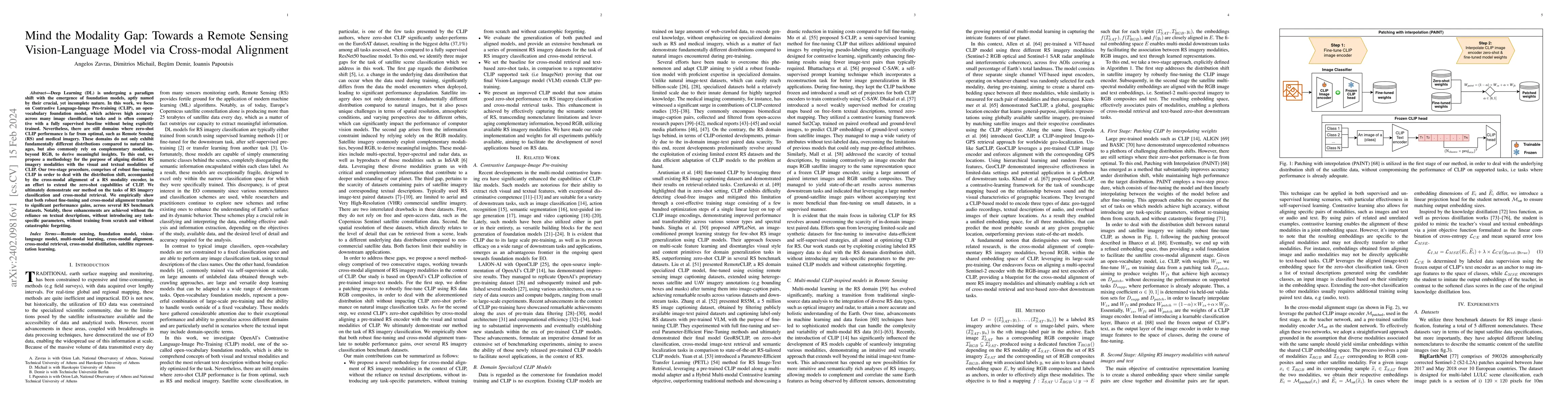
Deep Learning (DL) is undergoing a paradigm shift with the emergence of foundation models, aptly named by their crucial, yet incomplete nature. In this work, we focus on Contrastive Language-Image P...
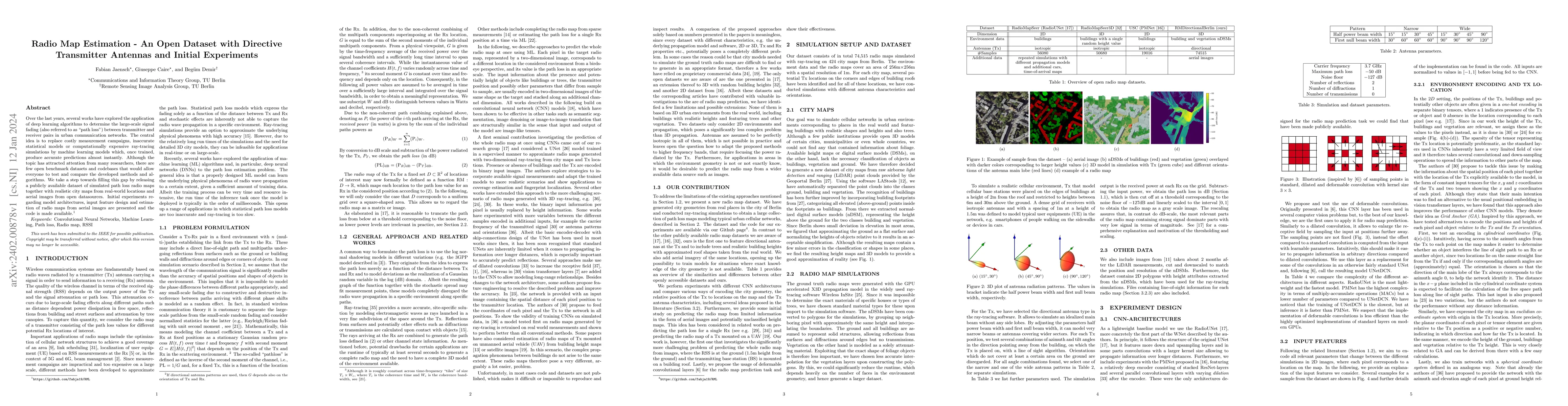
Over the last years, several works have explored the application of deep learning algorithms to determine the large-scale signal fading (also referred to as ``path loss'') between transmitter and re...
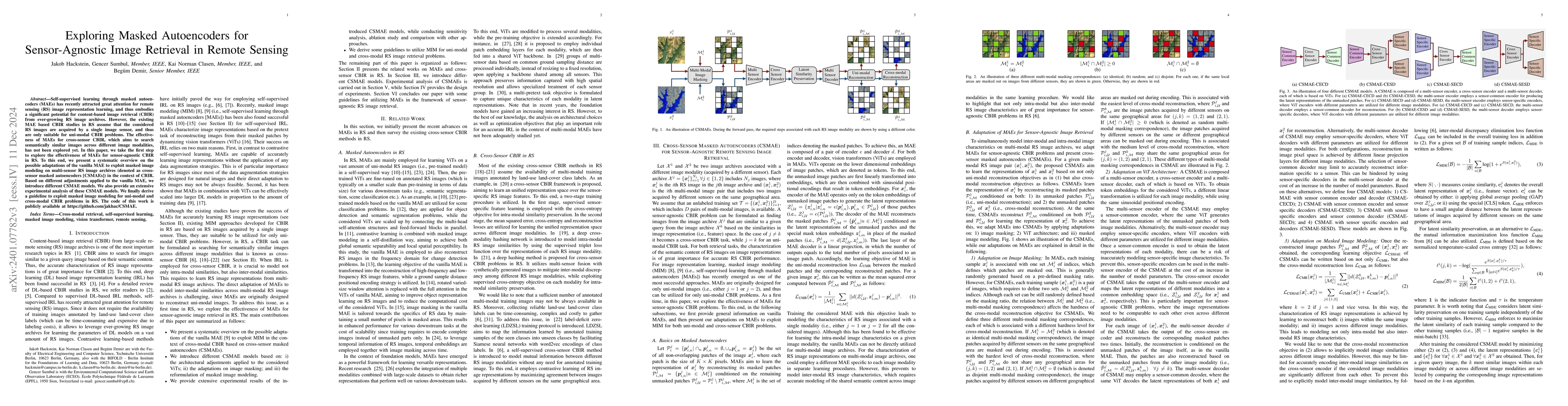
Self-supervised learning through masked autoencoders (MAEs) has recently attracted great attention for remote sensing (RS) image representation learning, and thus embodies a significant potential fo...
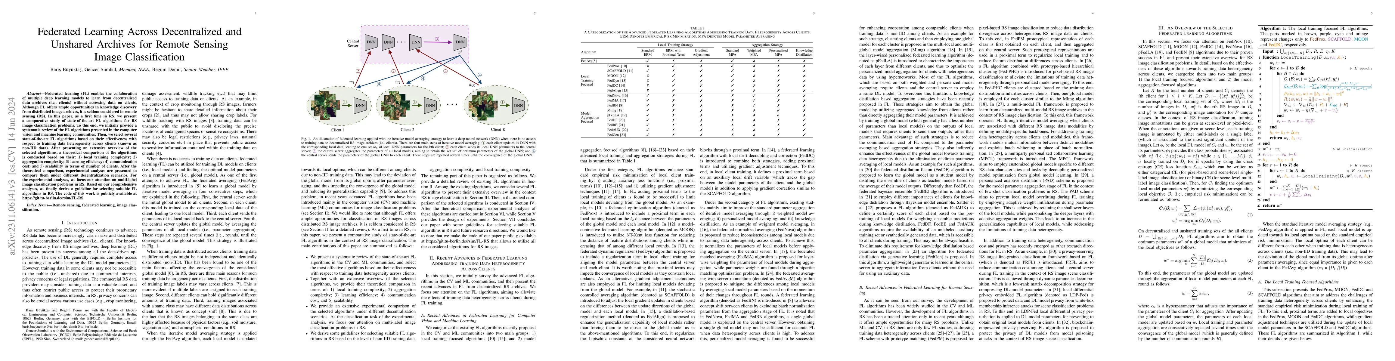
Federated learning (FL) enables the collaboration of multiple deep learning models to learn from decentralized data archives (i.e., clients) without accessing data on clients. Although FL offers amp...
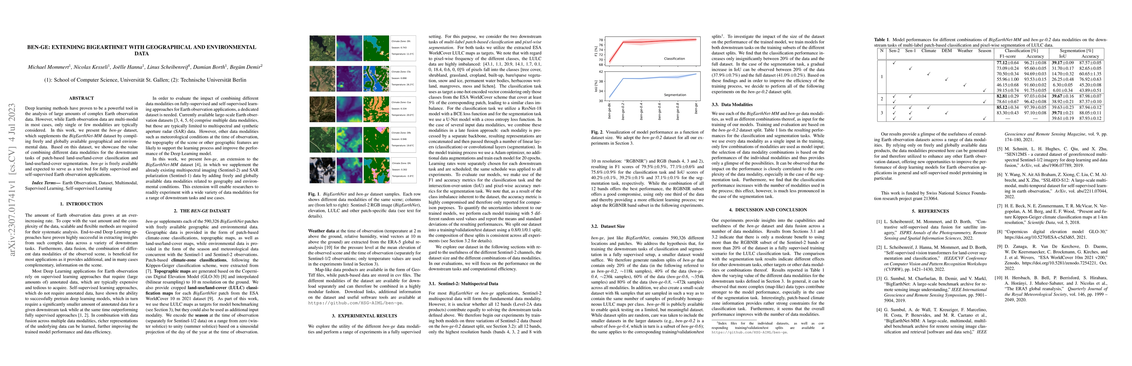
Deep learning methods have proven to be a powerful tool in the analysis of large amounts of complex Earth observation data. However, while Earth observation data are multi-modal in most cases, only ...
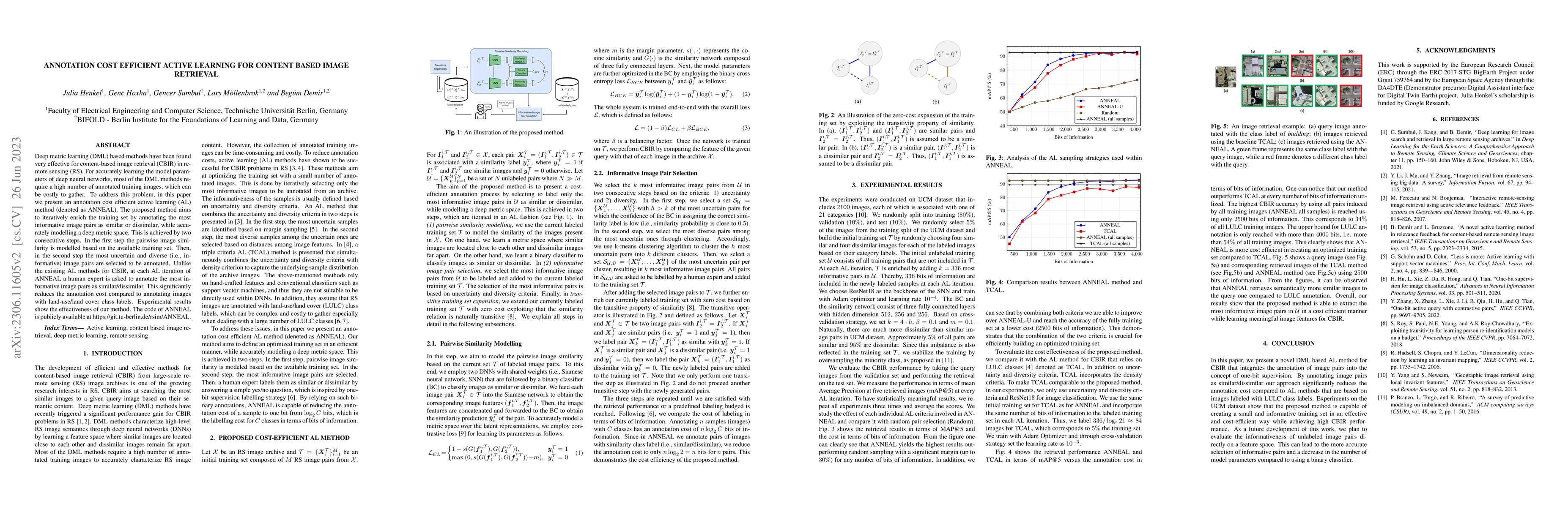
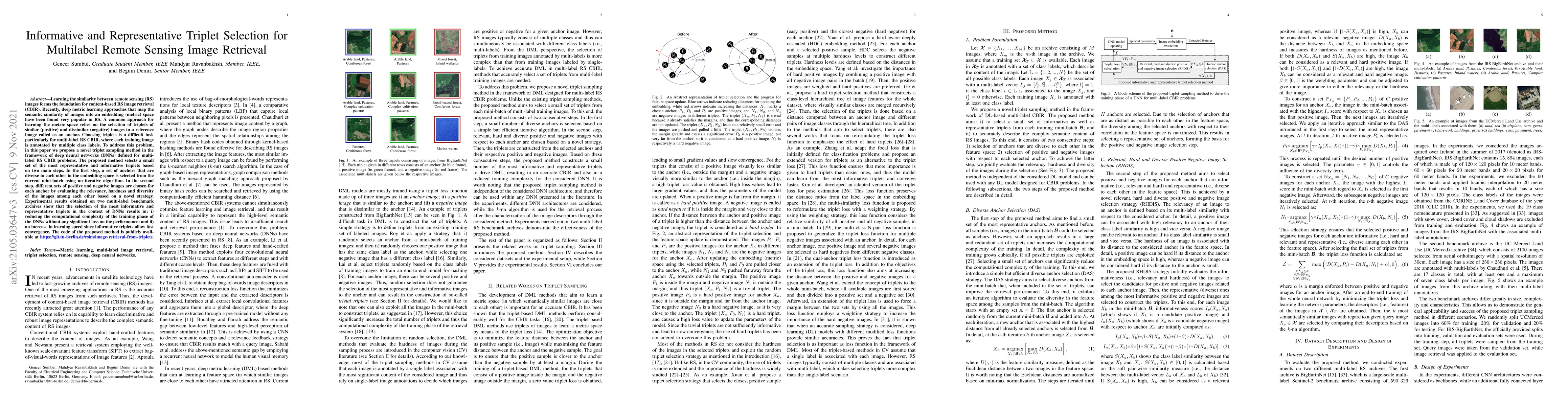
Deep metric learning (DML) based methods have been found very effective for content-based image retrieval (CBIR) in remote sensing (RS). For accurately learning the model parameters of deep neural n...
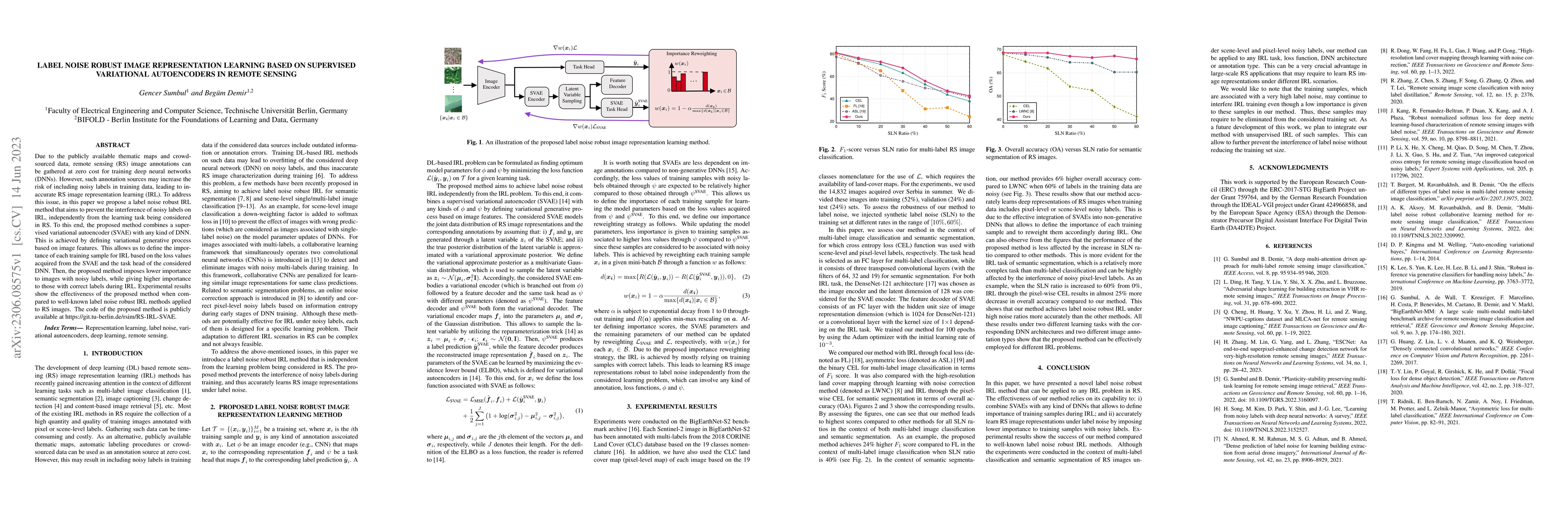
Due to the publicly available thematic maps and crowd-sourced data, remote sensing (RS) image annotations can be gathered at zero cost for training deep neural networks (DNNs). However, such annotat...
In recent years, deep neural networks (DNNs) have been found very successful for multi-label classification (MLC) of remote sensing (RS) images. Self-supervised pre-training combined with fine-tunin...
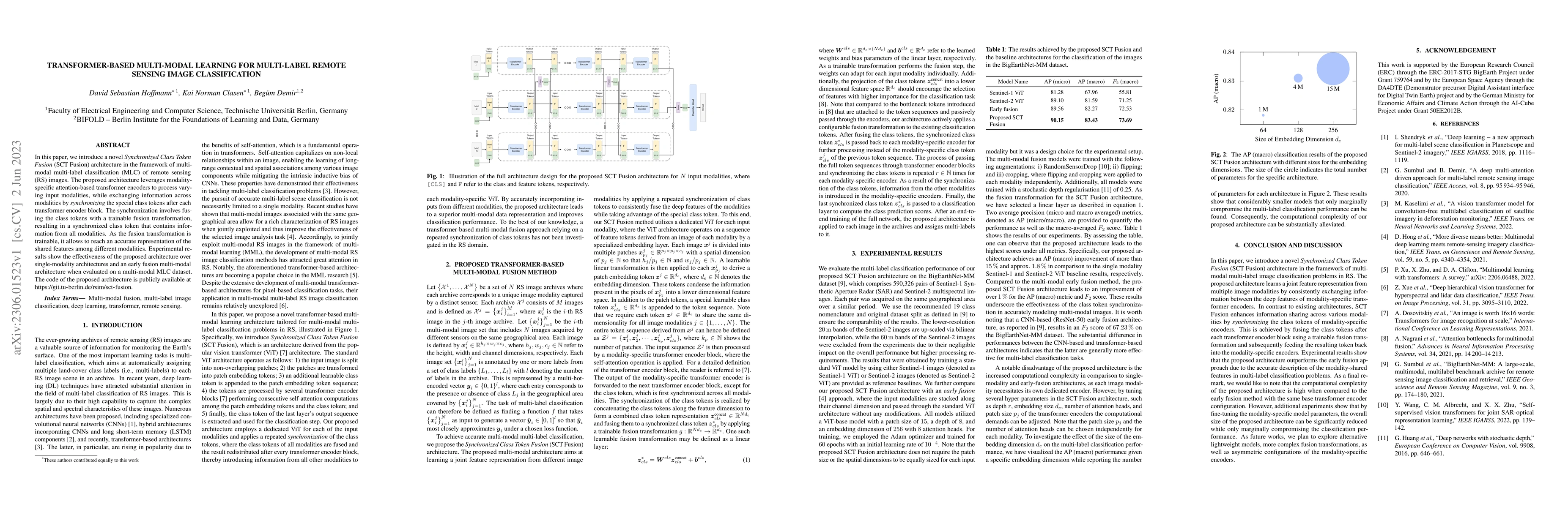
In this paper, we introduce a novel Synchronized Class Token Fusion (SCT Fusion) architecture in the framework of multi-modal multi-label classification (MLC) of remote sensing (RS) images. The prop...
The development of federated learning (FL) methods, which aim to learn from distributed databases (i.e., clients) without accessing data on clients, has recently attracted great attention. Most of t...
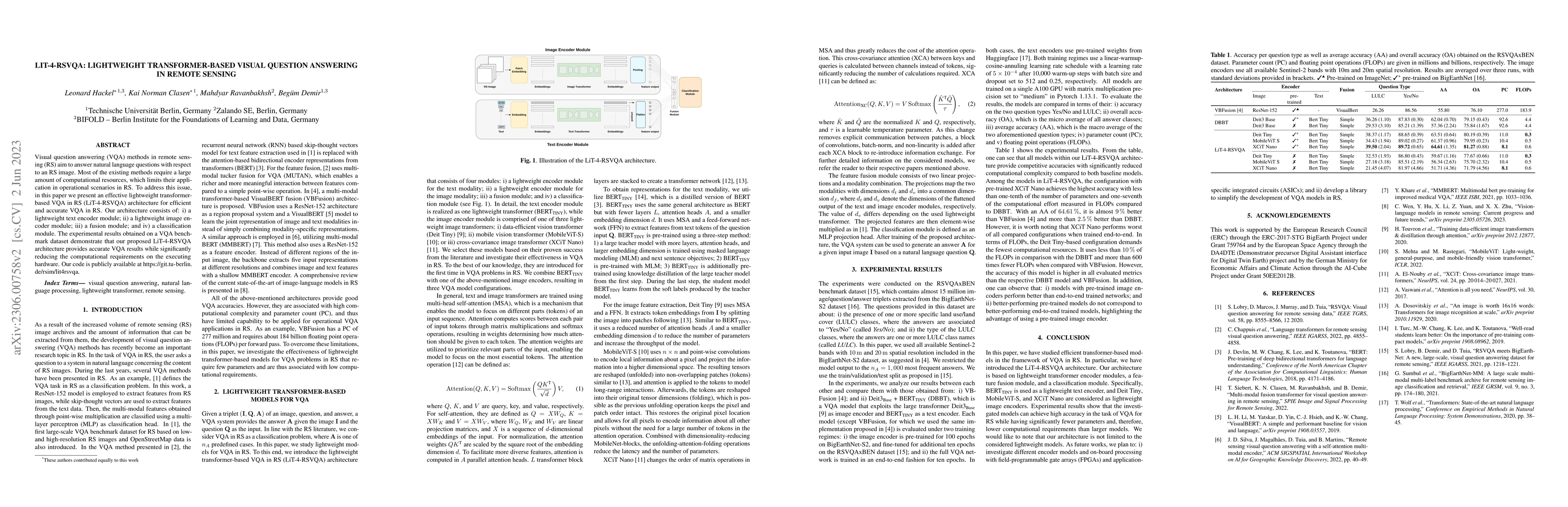
Visual question answering (VQA) methods in remote sensing (RS) aim to answer natural language questions with respect to an RS image. Most of the existing methods require a large amount of computatio...
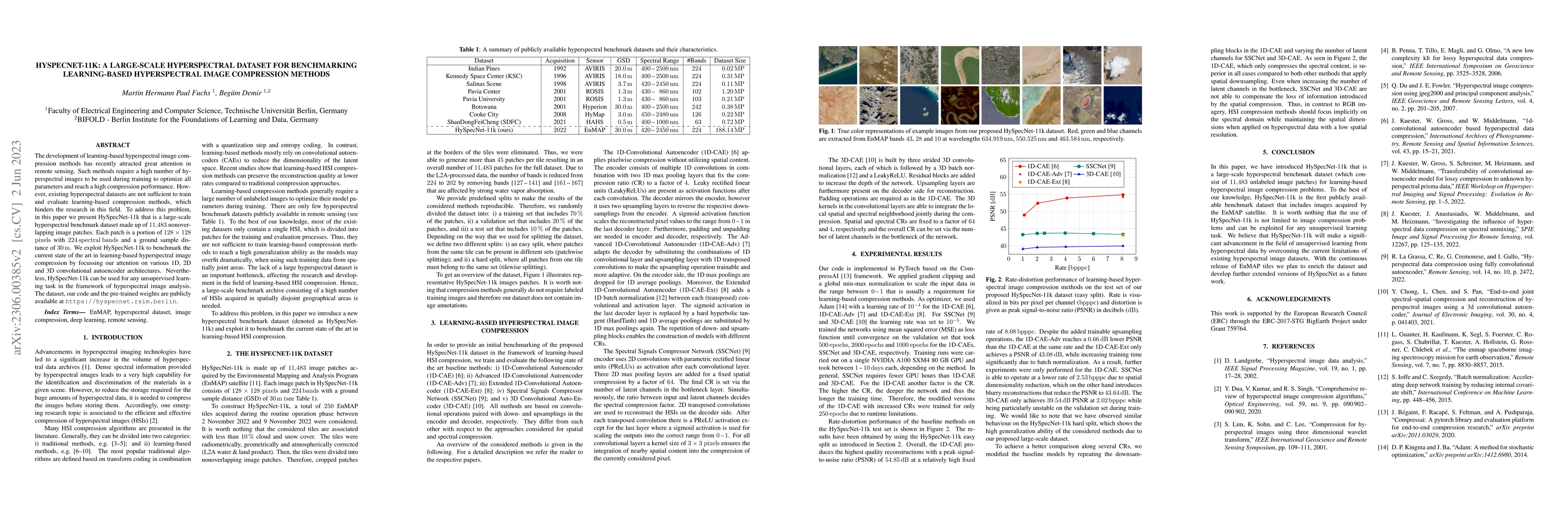
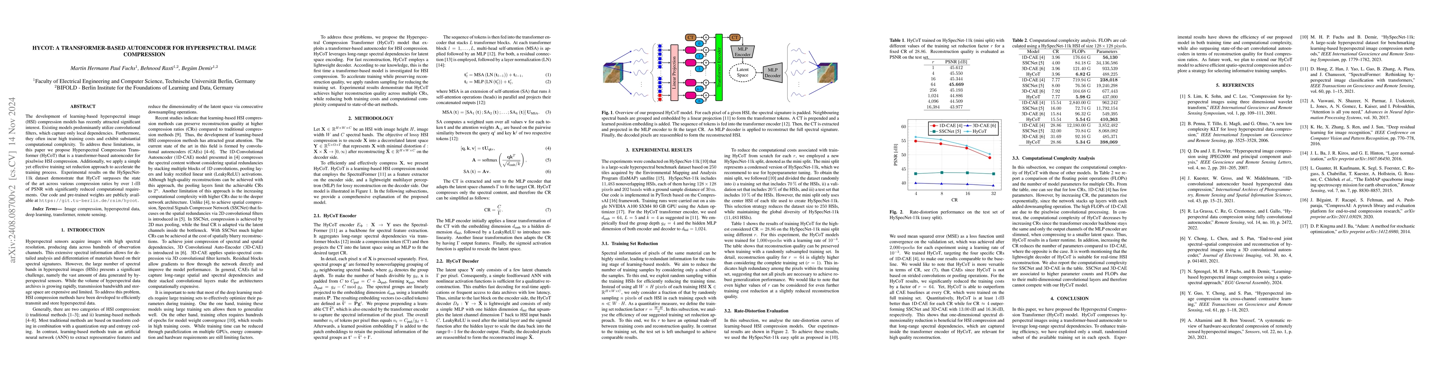
The development of learning-based hyperspectral image compression methods has recently attracted great attention in remote sensing. Such methods require a high number of hyperspectral images to be u...
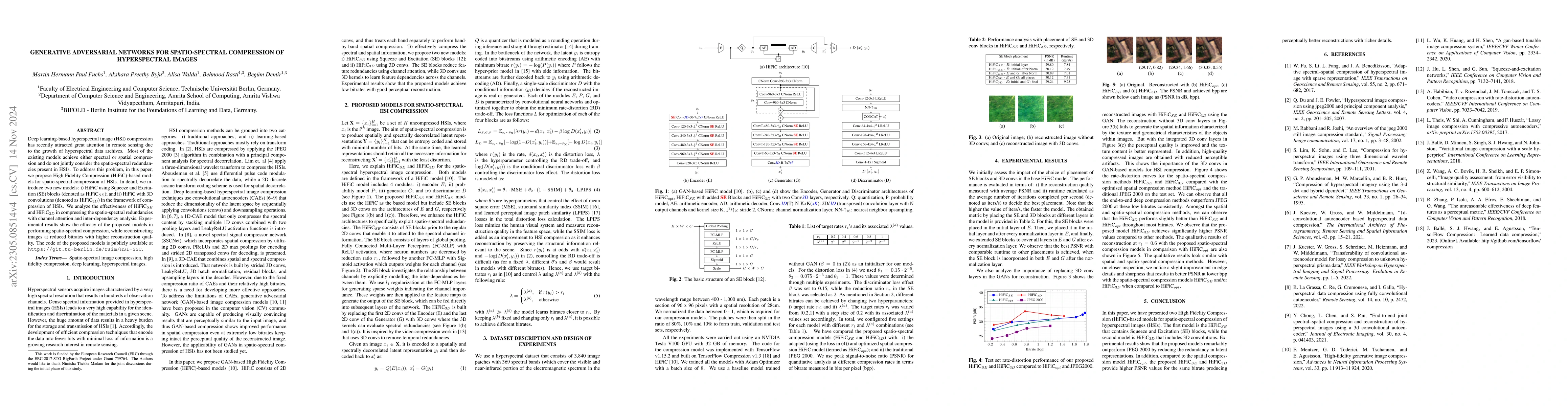
The development of deep learning-based models for the compression of hyperspectral images (HSIs) has recently attracted great attention in remote sensing due to the sharp growing of hyperspectral da...
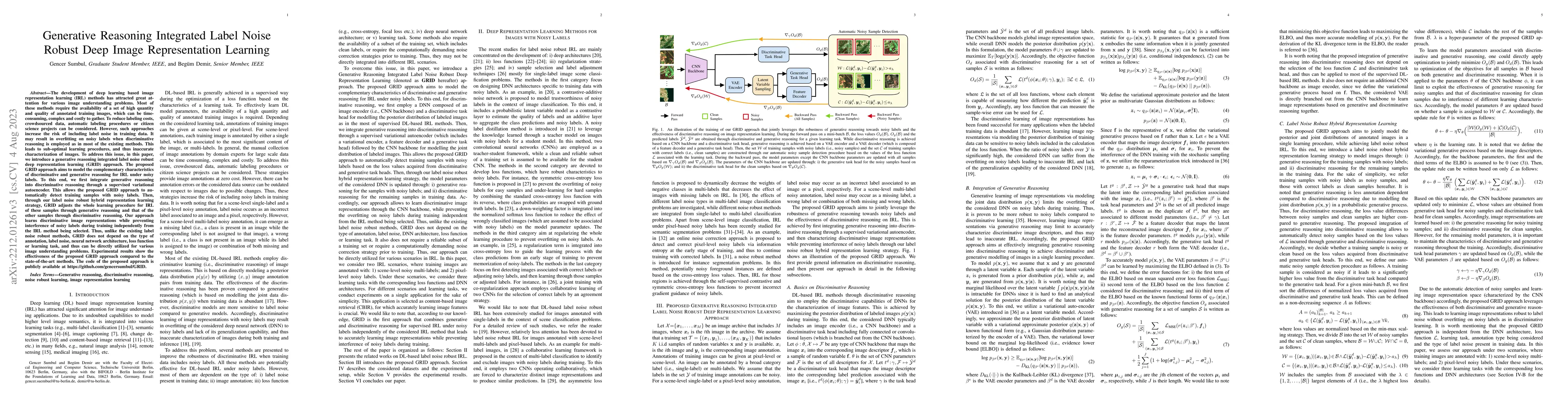
The development of deep learning based image representation learning (IRL) methods has attracted great attention for various image understanding problems. Most of these methods require the availabil...
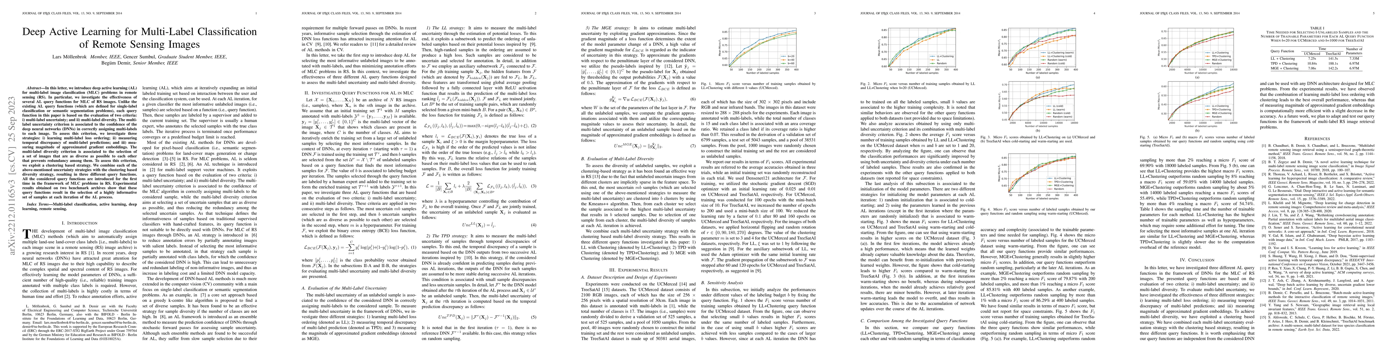
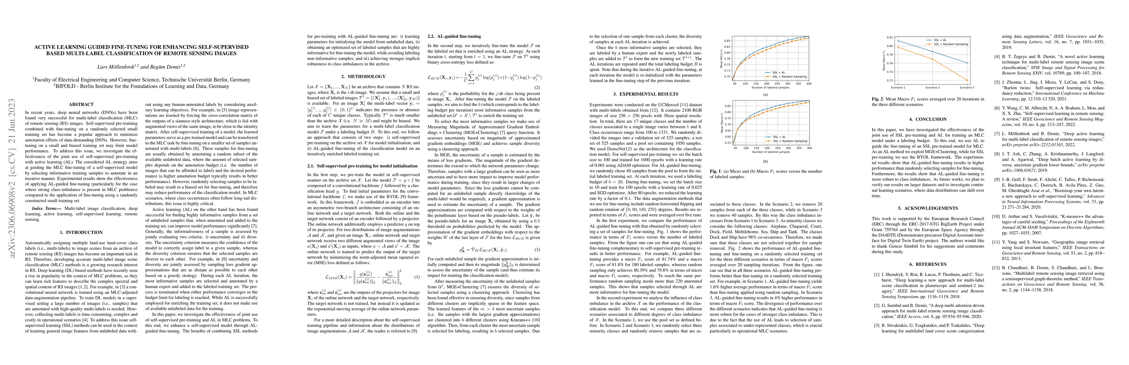
In this letter, we introduce deep active learning (AL) for multi-label classification (MLC) problems in remote sensing (RS). In particular, we investigate the effectiveness of several AL query funct...
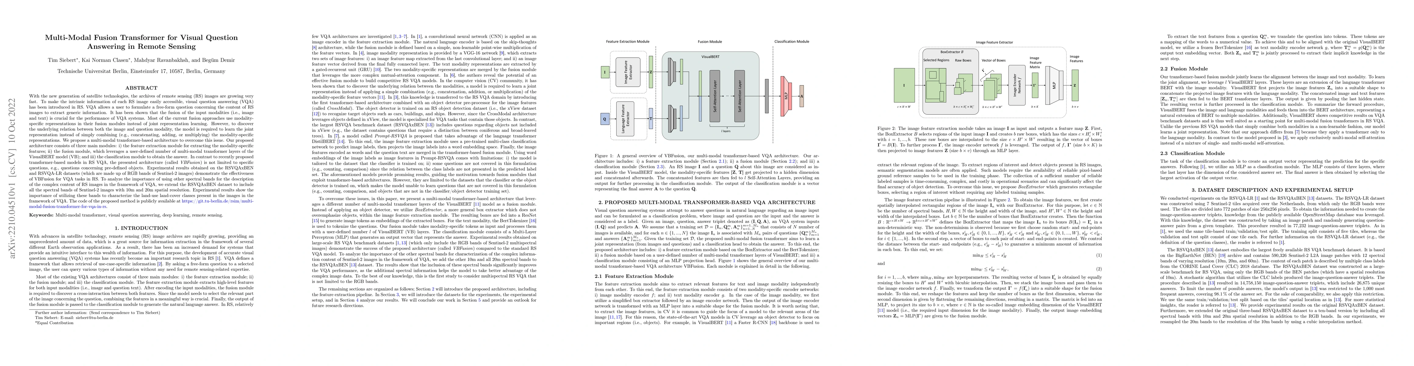
With the new generation of satellite technologies, the archives of remote sensing (RS) images are growing very fast. To make the intrinsic information of each RS image easily accessible, visual ques...
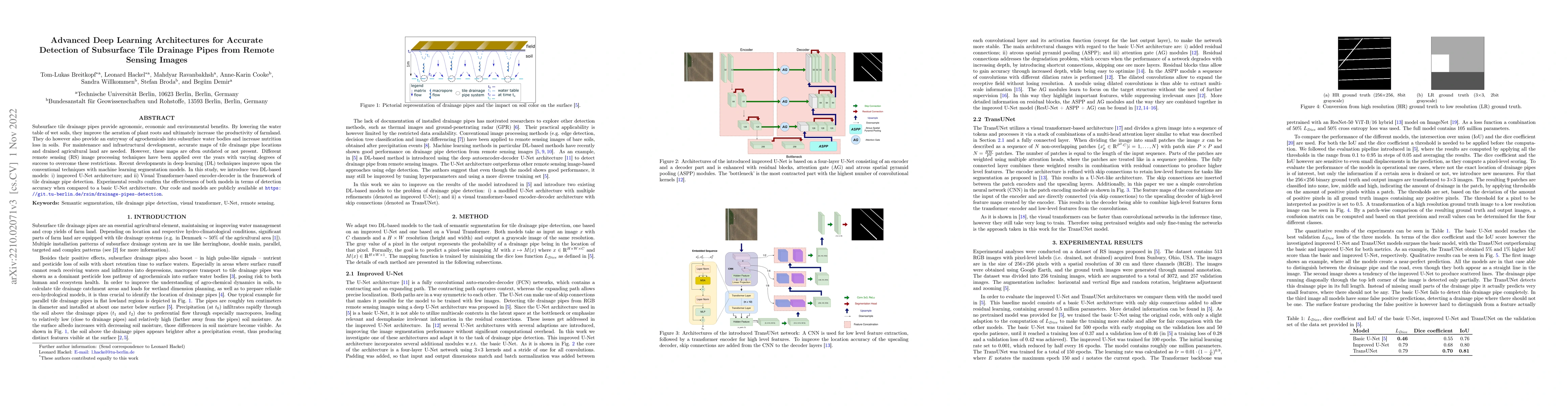
Subsurface tile drainage pipes provide agronomic, economic and environmental benefits. By lowering the water table of wet soils, they improve the aeration of plant roots and ultimately increase the ...
The growing operational capability of global Earth Observation (EO) creates new opportunities for data-driven approaches to understand and protect our planet. However, the current use of EO archives...
The development of accurate methods for multi-label classification (MLC) of remote sensing (RS) images is one of the most important research topics in RS. To address MLC problems, the use of deep ne...
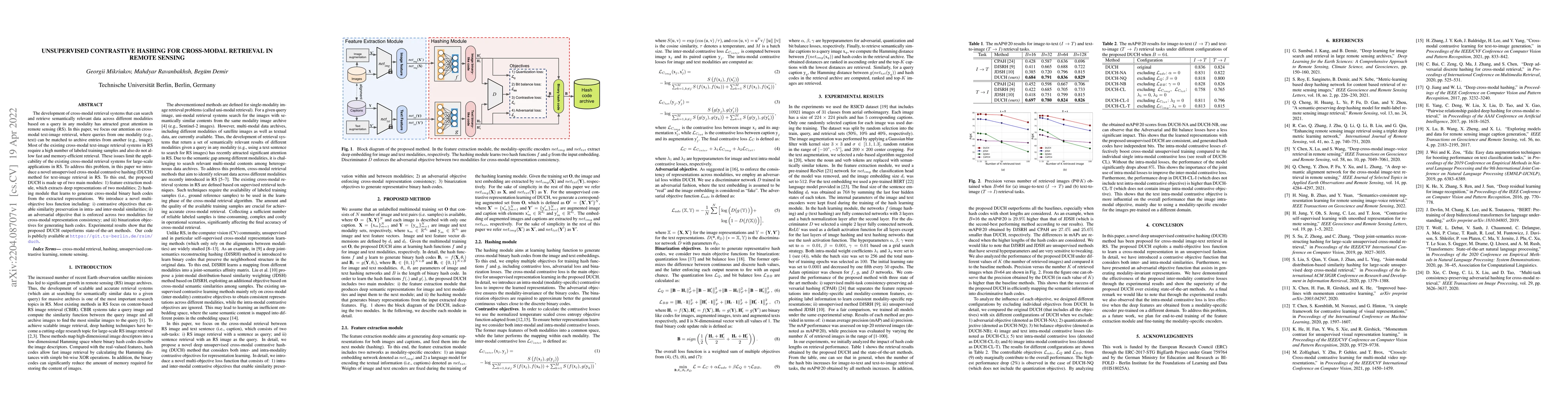
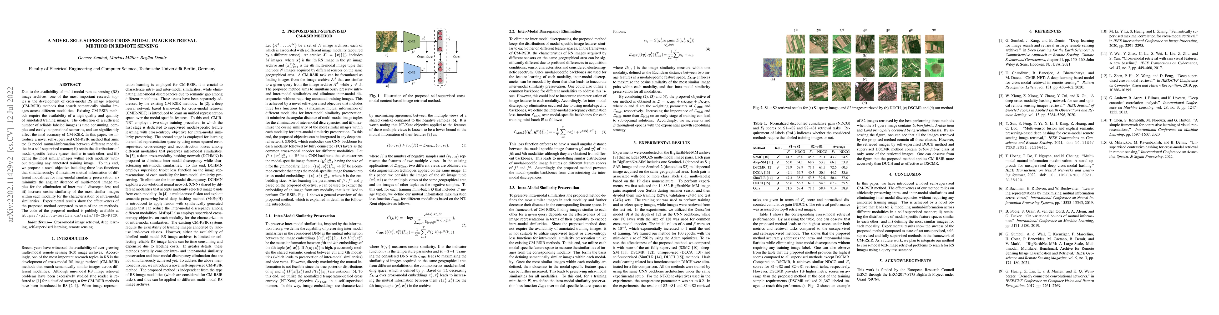
The development of cross-modal retrieval systems that can search and retrieve semantically relevant data across different modalities based on a query in any modality has attracted great attention in...

Machine Learning (ML) techniques are employed to analyze and process big Remote Sensing (RS) data, and one well-known ML technique is a Support Vector Machine (SVM). An SVM is a quadratic programmin...
The development of accurate and scalable cross-modal image-text retrieval methods, where queries from one modality (e.g., text) can be matched to archive entries from another (e.g., remote sensing i...
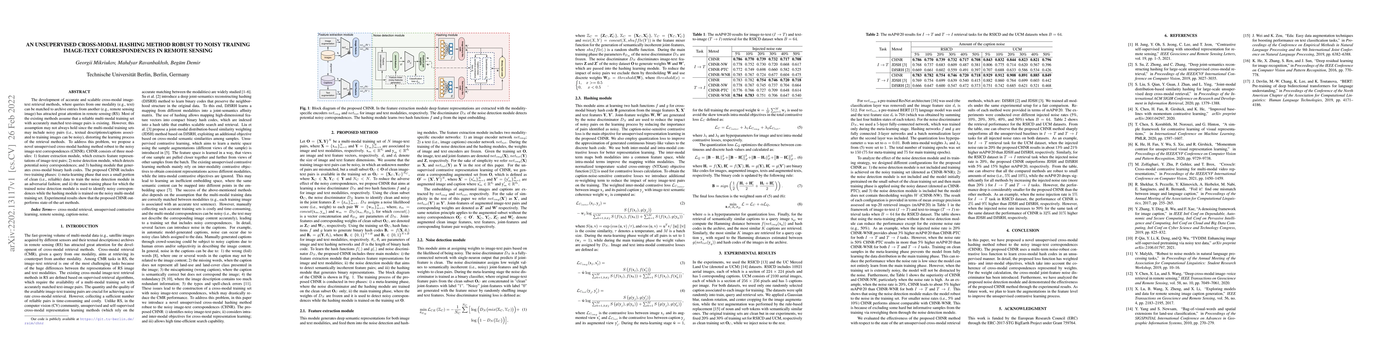
Due to the availability of multi-modal remote sensing (RS) image archives, one of the most important research topics is the development of cross-modal RS image retrieval (CM-RSIR) methods that searc...
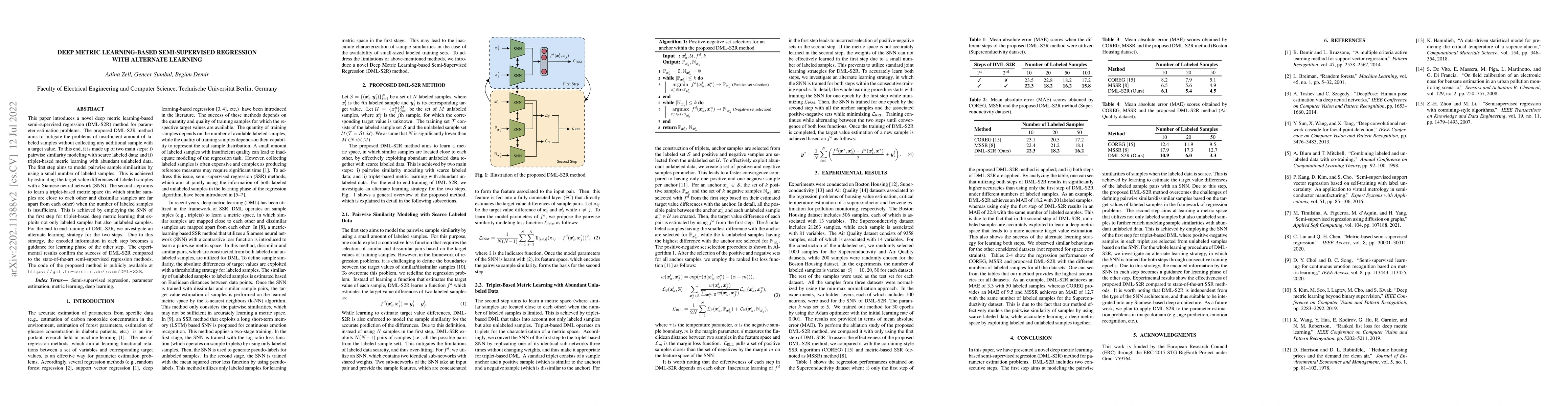
This paper introduces a novel deep metric learning-based semi-supervised regression (DML-S2R) method for parameter estimation problems. The proposed DML-S2R method aims to mitigate the problems of i...
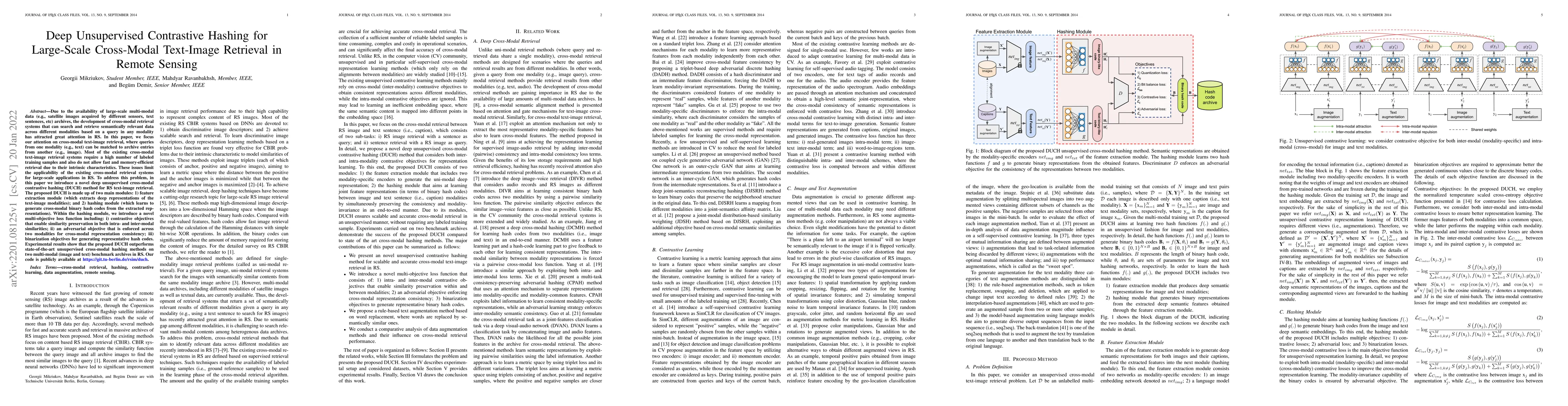
Due to the availability of large-scale multi-modal data (e.g., satellite images acquired by different sensors, text sentences, etc) archives, the development of cross-modal retrieval systems that ca...
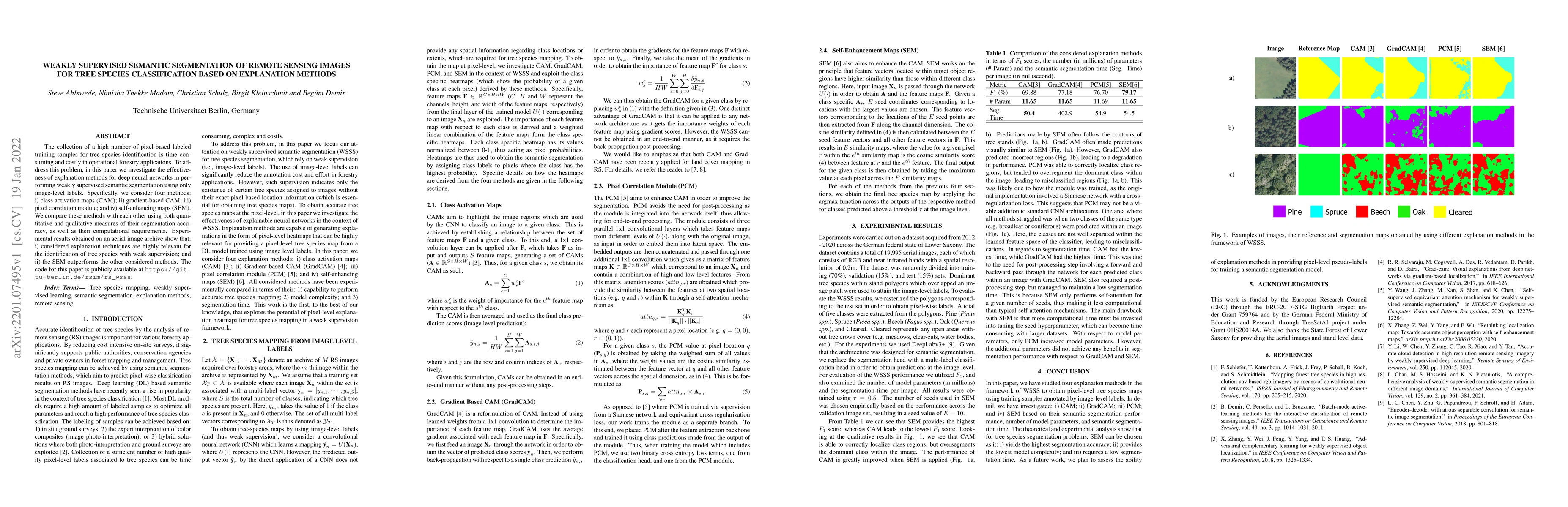
The collection of a high number of pixel-based labeled training samples for tree species identification is time consuming and costly in operational forestry applications. To address this problem, in...
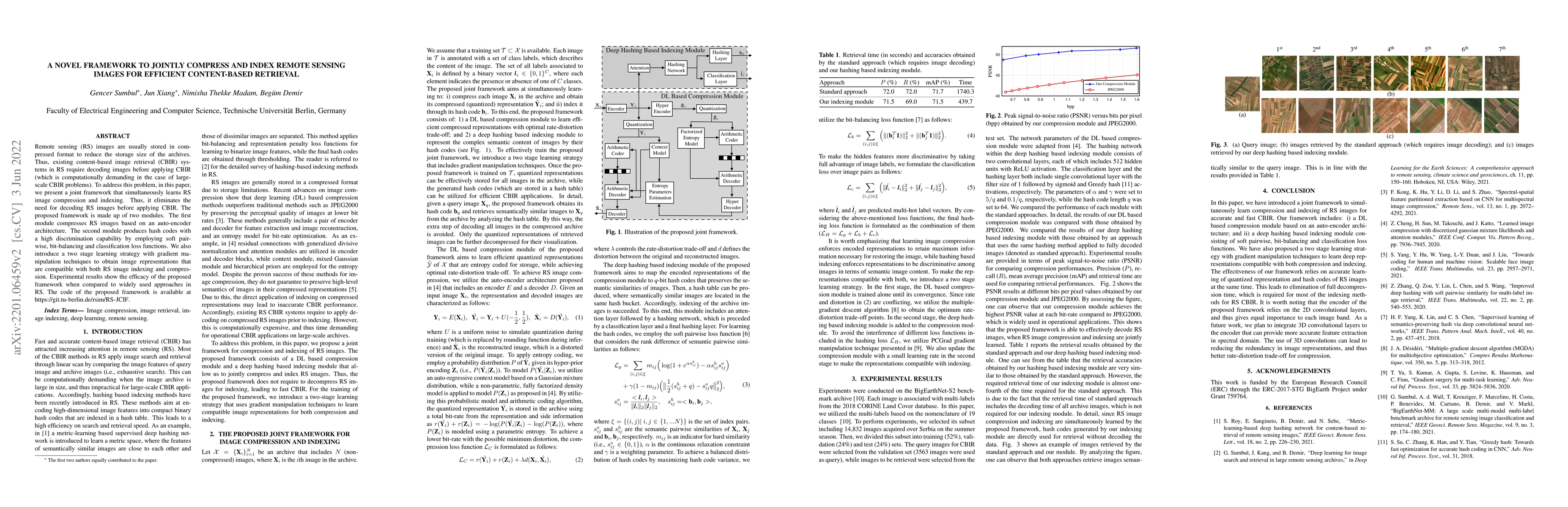
Remote sensing (RS) images are usually stored in compressed format to reduce the storage size of the archives. Thus, existing content-based image retrieval (CBIR) systems in RS require decoding imag...
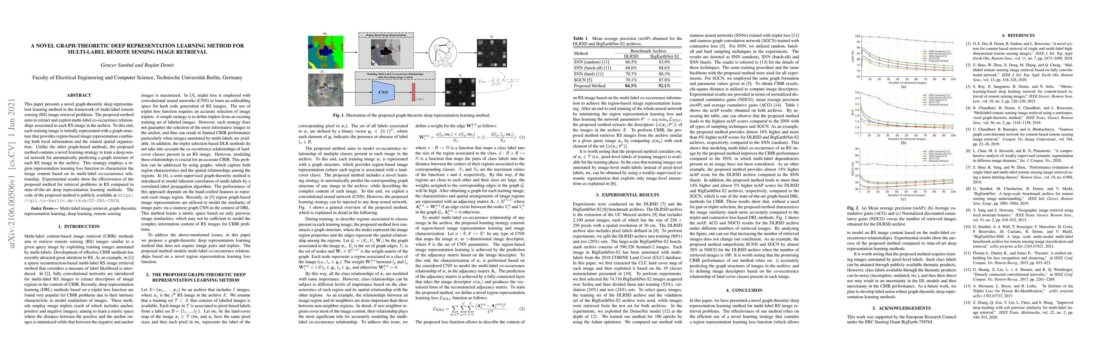
This paper presents a novel graph-theoretic deep representation learning method in the framework of multi-label remote sensing (RS) image retrieval problems. The proposed method aims to extract and ...
Learning the similarity between remote sensing (RS) images forms the foundation for content-based RS image retrieval (CBIR). Recently, deep metric learning approaches that map the semantic similarit...
The development of accurate methods for multi-label classification (MLC) of remote sensing (RS) images is one of the most important research topics in RS. The MLC methods based on convolutional neur...
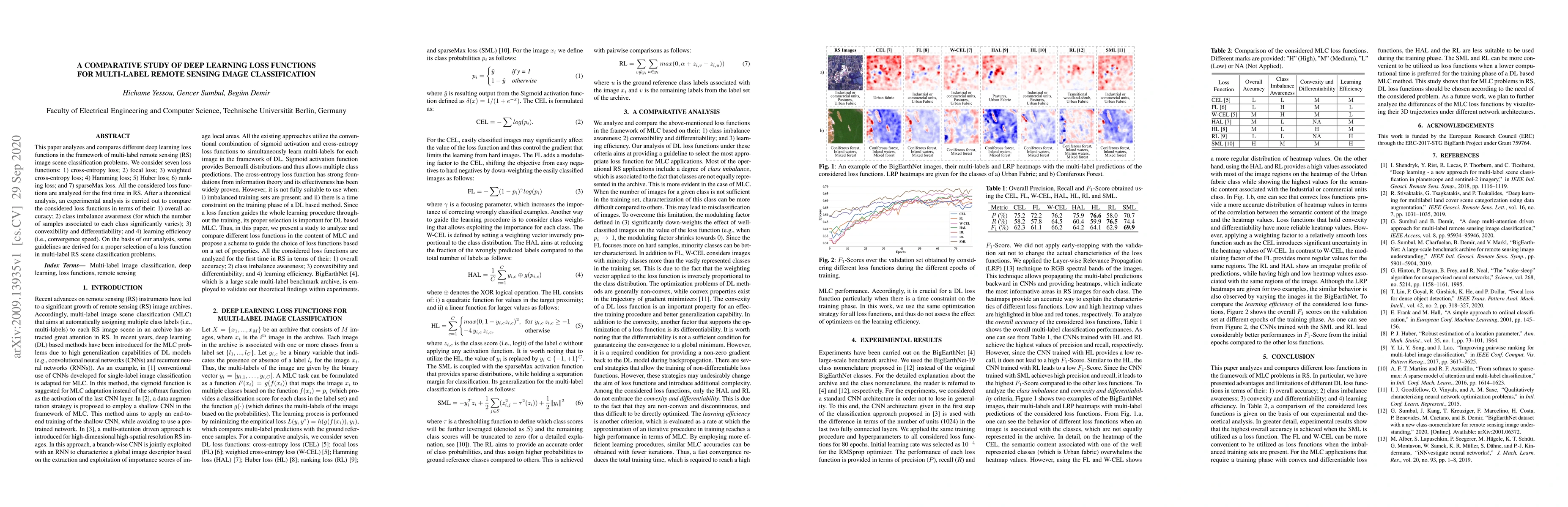
This paper analyzes and compares different deep learning loss functions in the framework of multi-label remote sensing (RS) image scene classification problems. We consider seven loss functions: 1) ...
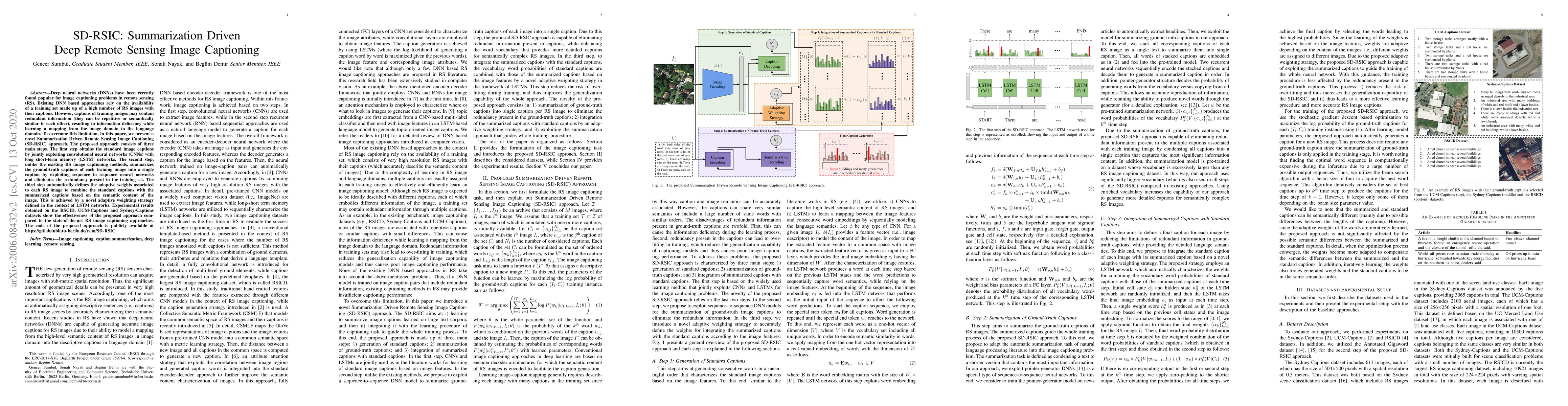
Deep neural networks (DNNs) have been recently found popular for image captioning problems in remote sensing (RS). Existing DNN based approaches rely on the availability of a training set made up of...
Interferometric phase restoration has been investigated for decades and most of the state-of-the-art methods have achieved promising performances for InSAR phase restoration. These methods generally...
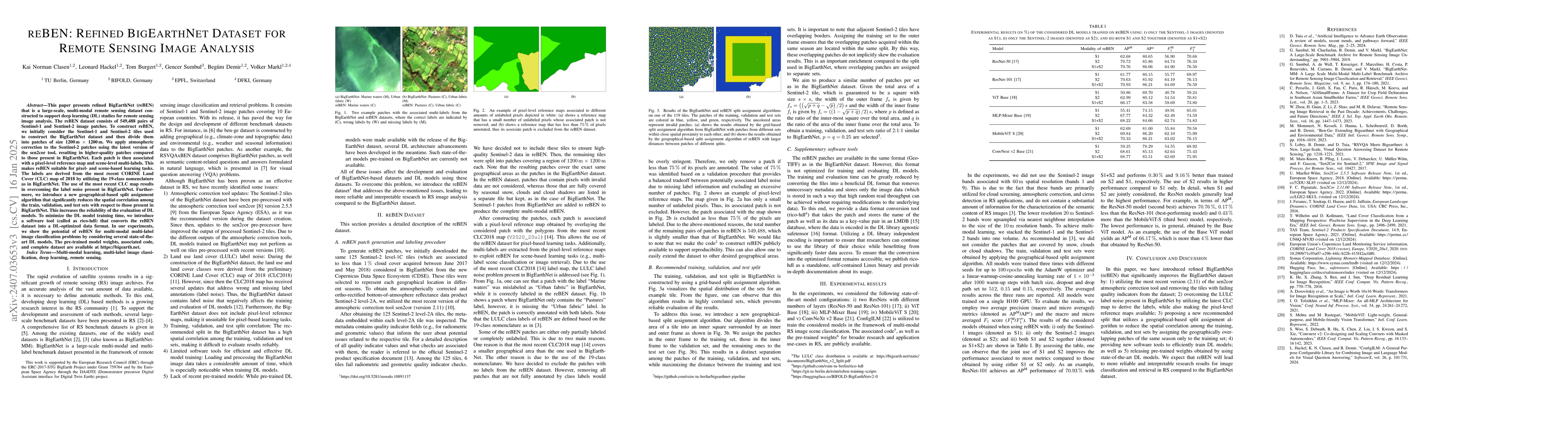
This paper presents refined BigEarthNet (reBEN) that is a large-scale, multi-modal remote sensing dataset constructed to support deep learning (DL) studies for remote sensing image analysis. The reBEN...
The development of learning-based hyperspectral image (HSI) compression models has recently attracted significant interest. Existing models predominantly utilize convolutional filters, which capture o...
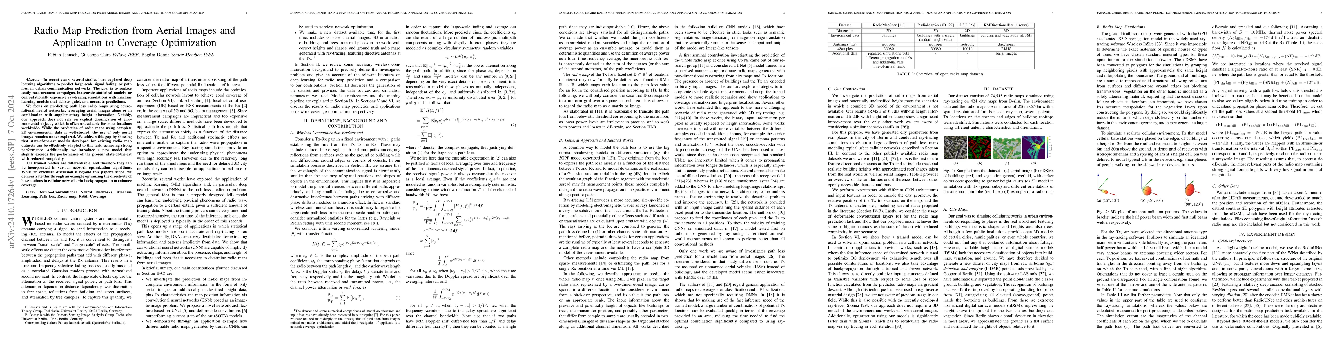
In recent years, several studies have explored deep learning algorithms to predict large-scale signal fading, or path loss, in urban communication networks. The goal is to replace costly measurement c...
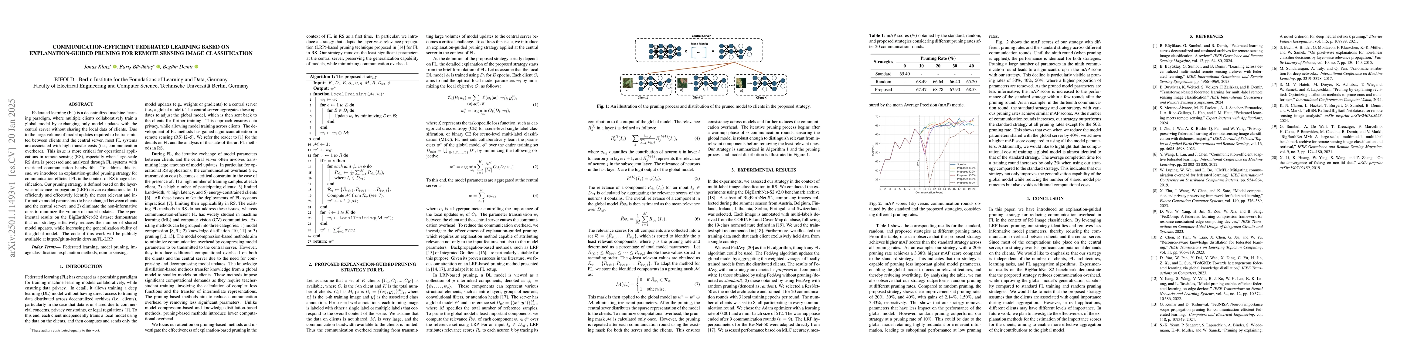
Federated learning (FL) is a decentralized machine learning paradigm, where multiple clients collaboratively train a global model by exchanging only model updates with the central server without shari...
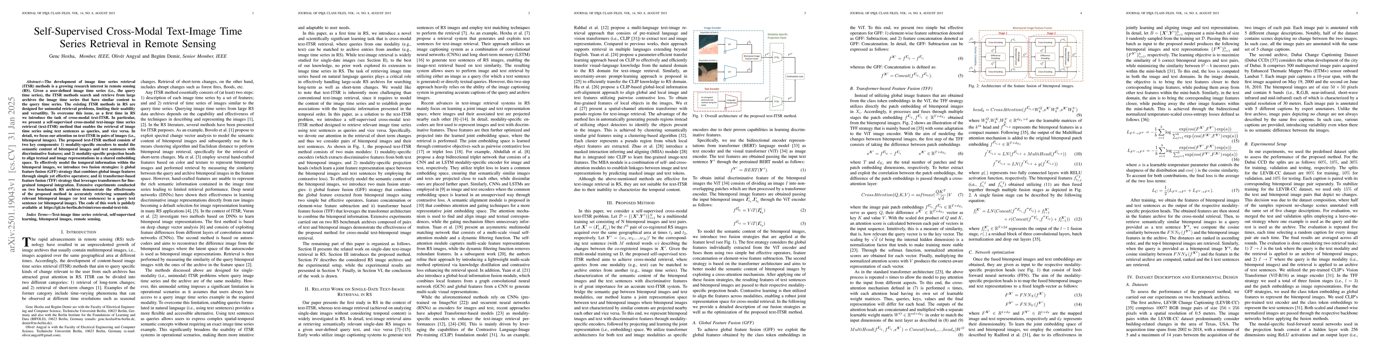
The development of image time series retrieval (ITSR) methods is a growing research interest in remote sensing (RS). Given a user-defined image time series (i.e., the query time series), the ITSR meth...
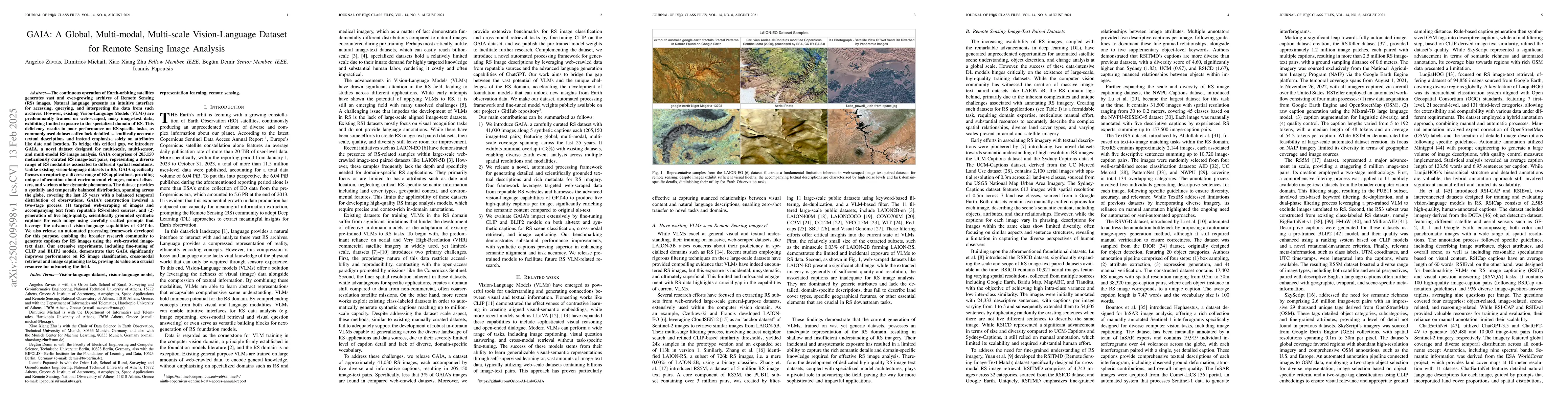
The continuous operation of Earth-orbiting satellites generates vast and ever-growing archives of Remote Sensing (RS) images. Natural language presents an intuitive interface for accessing, querying, ...
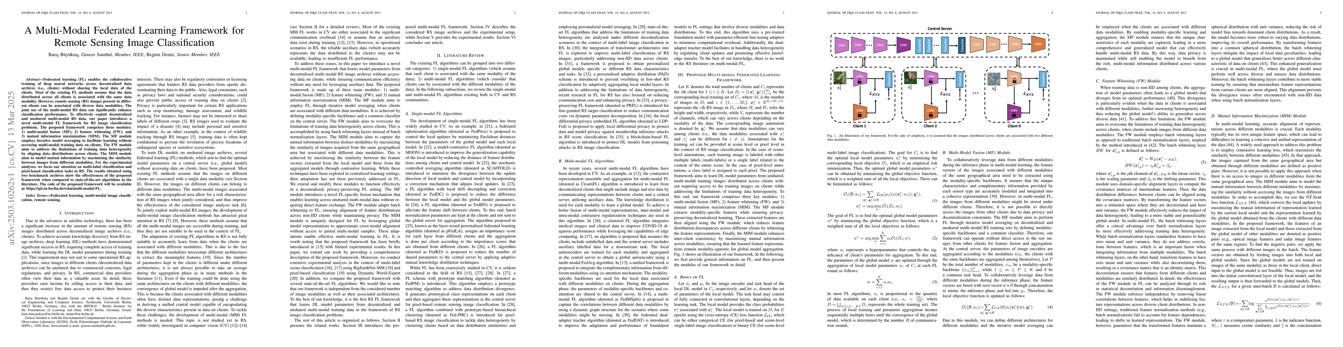
Federated learning (FL) enables the collaborative training of deep neural networks across decentralized data archives (i.e., clients) without sharing the local data of the clients. Most of the existin...
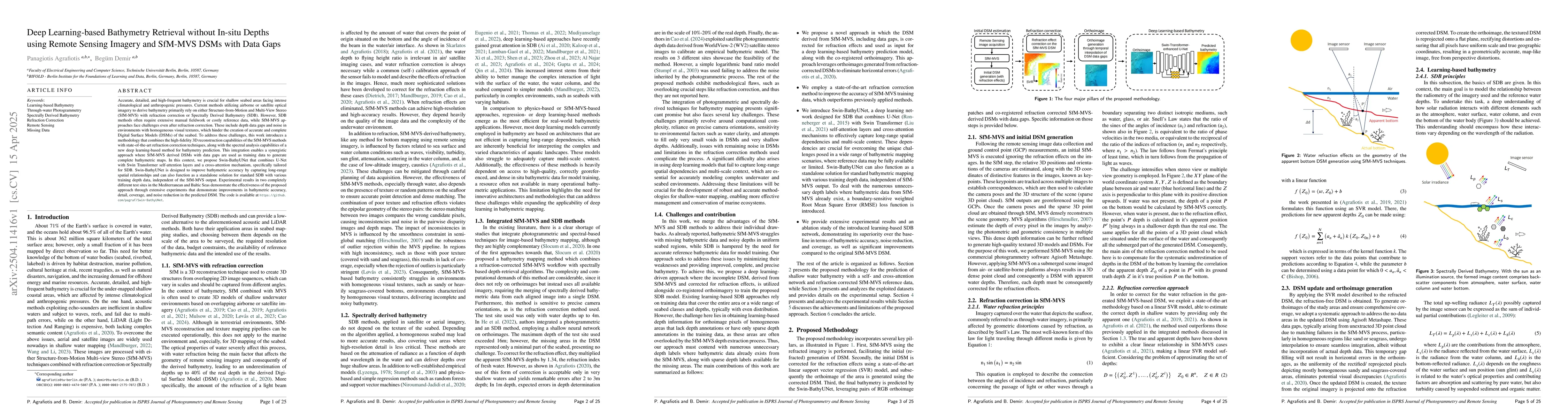
Accurate, detailed, and high-frequent bathymetry is crucial for shallow seabed areas facing intense climatological and anthropogenic pressures. Current methods utilizing airborne or satellite optical ...
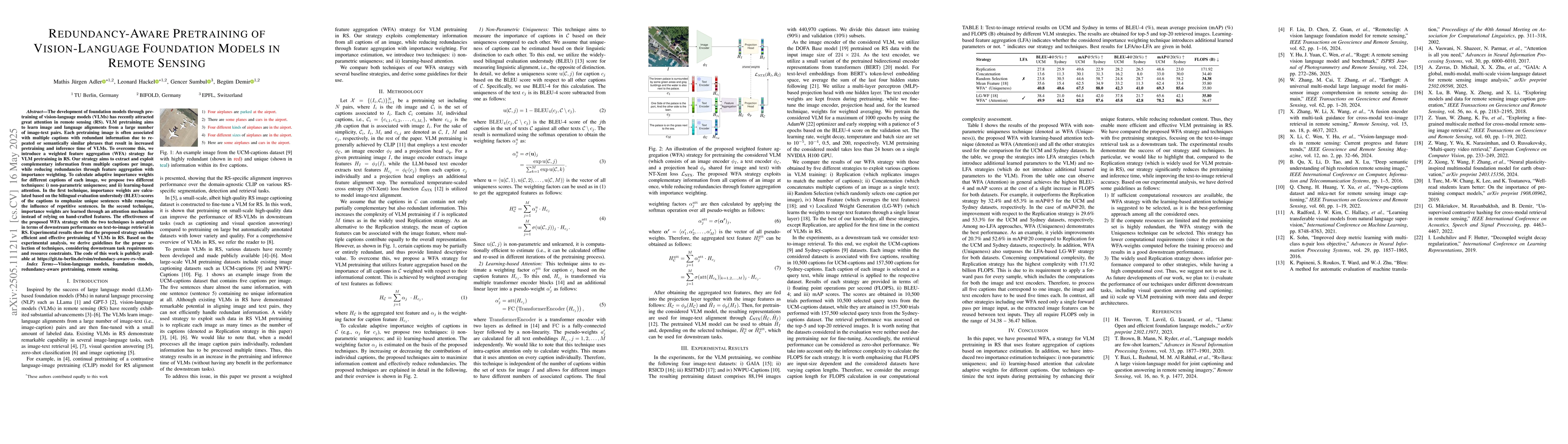
The development of foundation models through pretraining of vision-language models (VLMs) has recently attracted great attention in remote sensing (RS). VLM pretraining aims to learn image and languag...
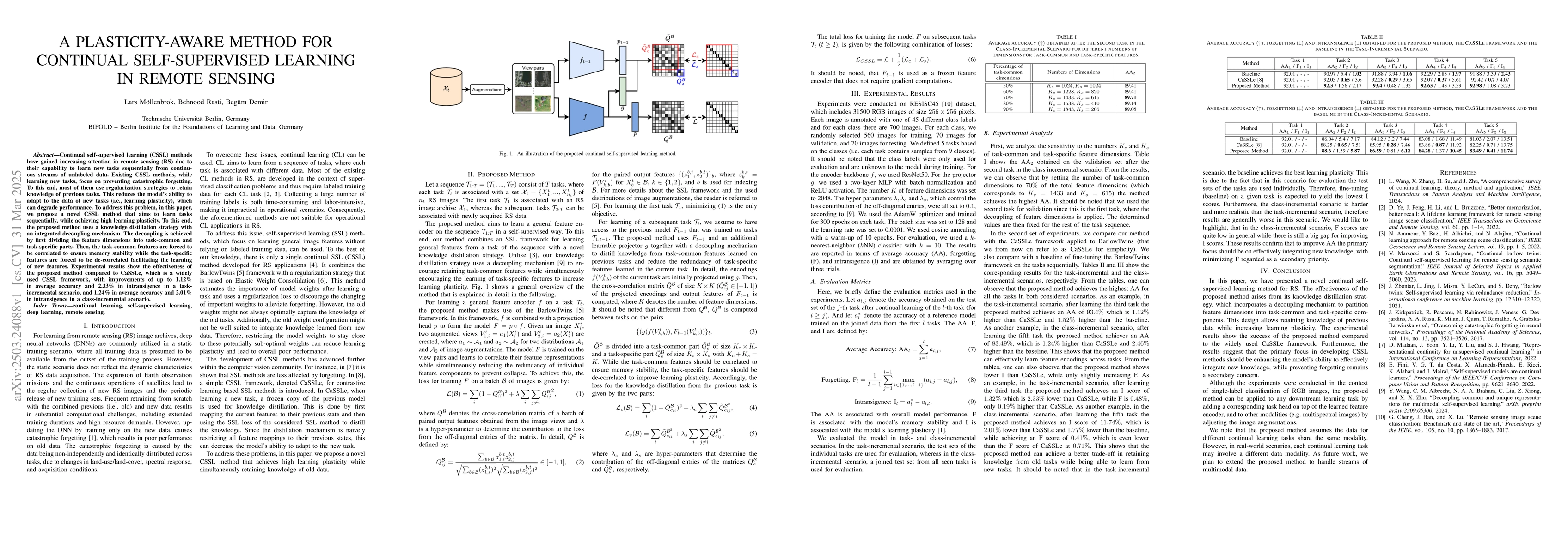
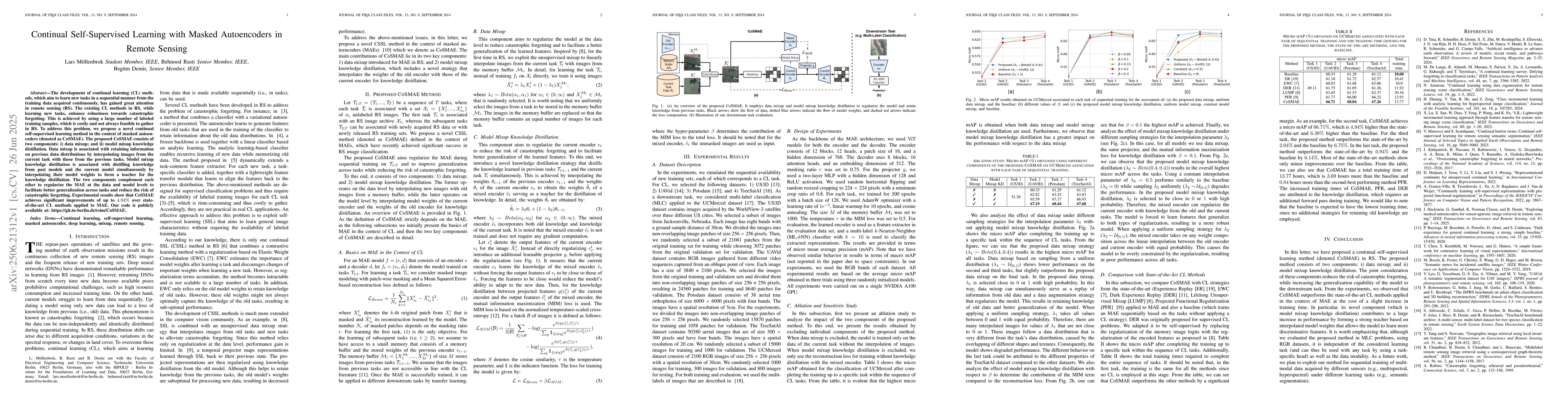
Continual self-supervised learning (CSSL) methods have gained increasing attention in remote sensing (RS) due to their capability to learn new tasks sequentially from continuous streams of unlabeled d...
The development of continual learning (CL) methods, which aim to learn new tasks in a sequential manner from the training data acquired continuously, has gained great attention in remote sensing (RS)....
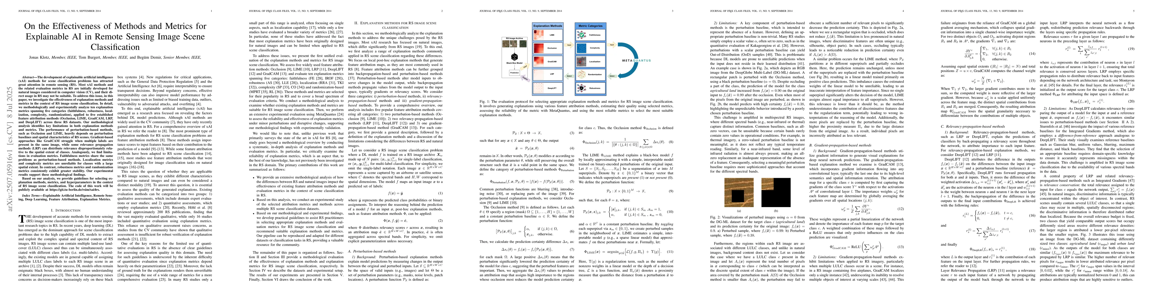
The development of explainable artificial intelligence (xAI) methods for scene classification problems has attracted great attention in remote sensing (RS). Most xAI methods and the related evaluation...
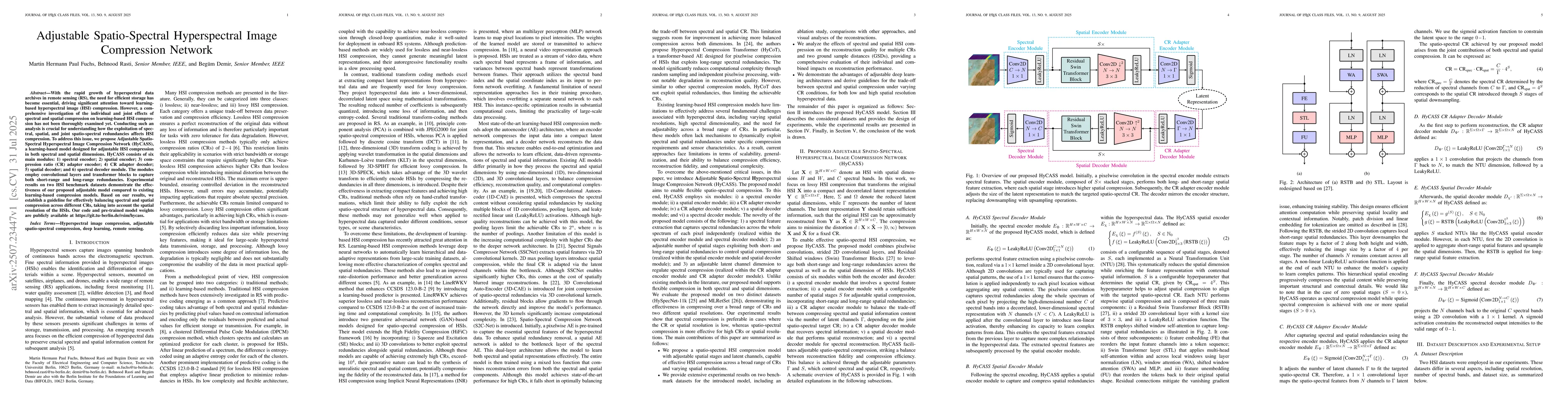
With the rapid growth of hyperspectral data archives in remote sensing (RS), the need for efficient storage has become essential, driving significant attention toward learning-based hyperspectral imag...
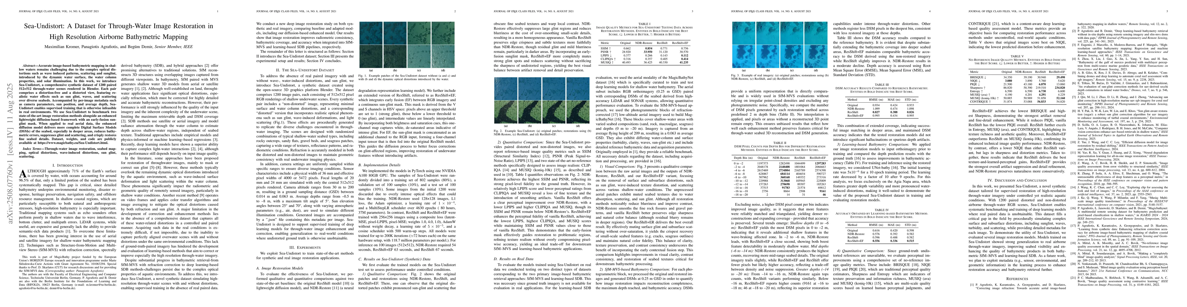
Accurate image-based bathymetric mapping in shallow waters remains challenging due to the complex optical distortions such as wave induced patterns, scattering and sunglint, introduced by the dynamic ...
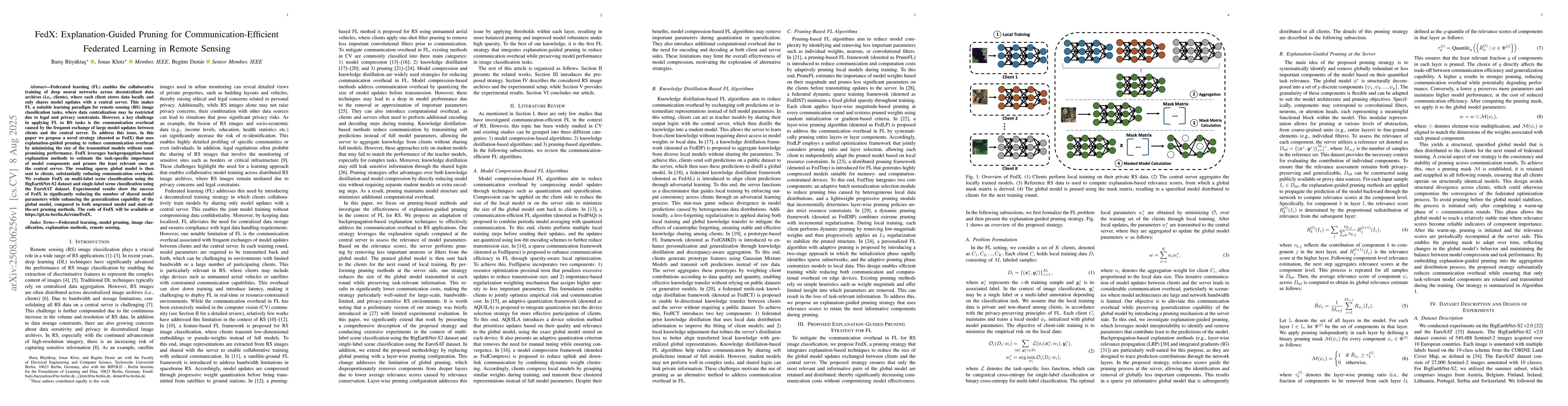
Federated learning (FL) enables the collaborative training of deep neural networks across decentralized data archives (i.e., clients), where each client stores data locally and only shares model updat...
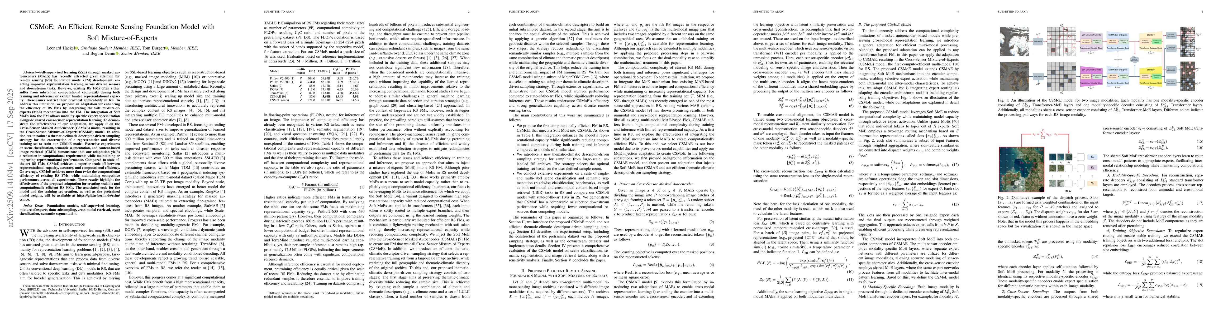
Self-supervised learning through masked autoencoders has attracted great attention for remote sensing (RS) foundation model (FM) development, enabling improved representation learning across diverse s...
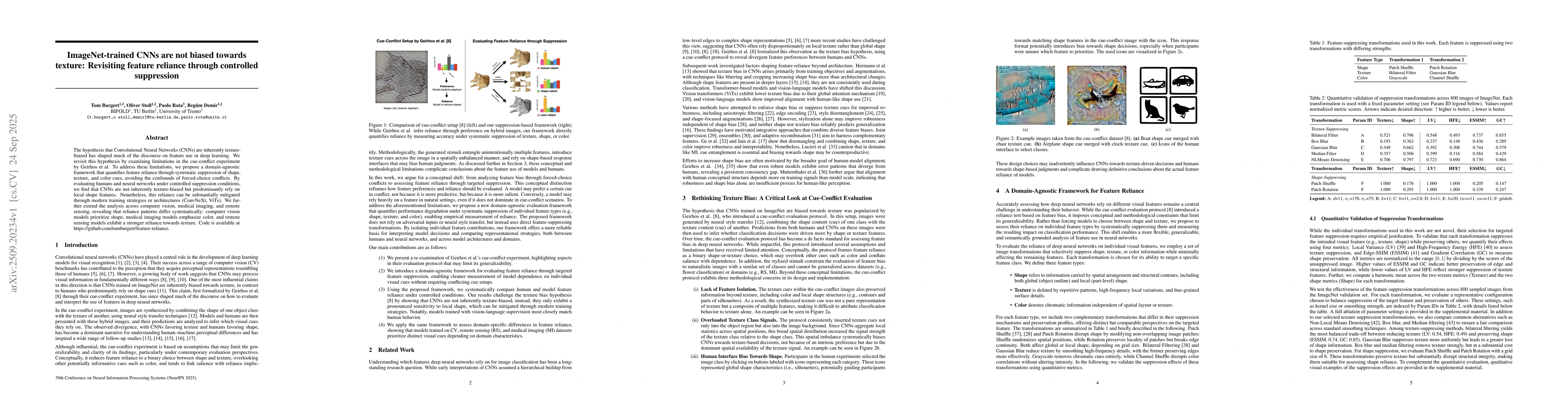
The hypothesis that Convolutional Neural Networks (CNNs) are inherently texture-biased has shaped much of the discourse on feature use in deep learning. We revisit this hypothesis by examining limitat...
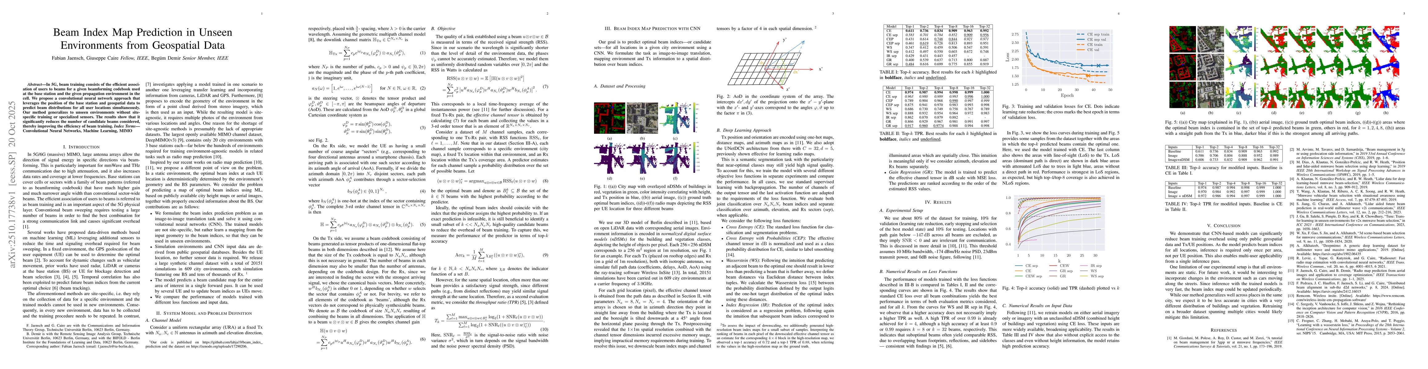
In 5G, beam training consists of the efficient association of users to beams for a given beamforming codebook used at the base station and the given propagation environment in the cell. We propose a c...
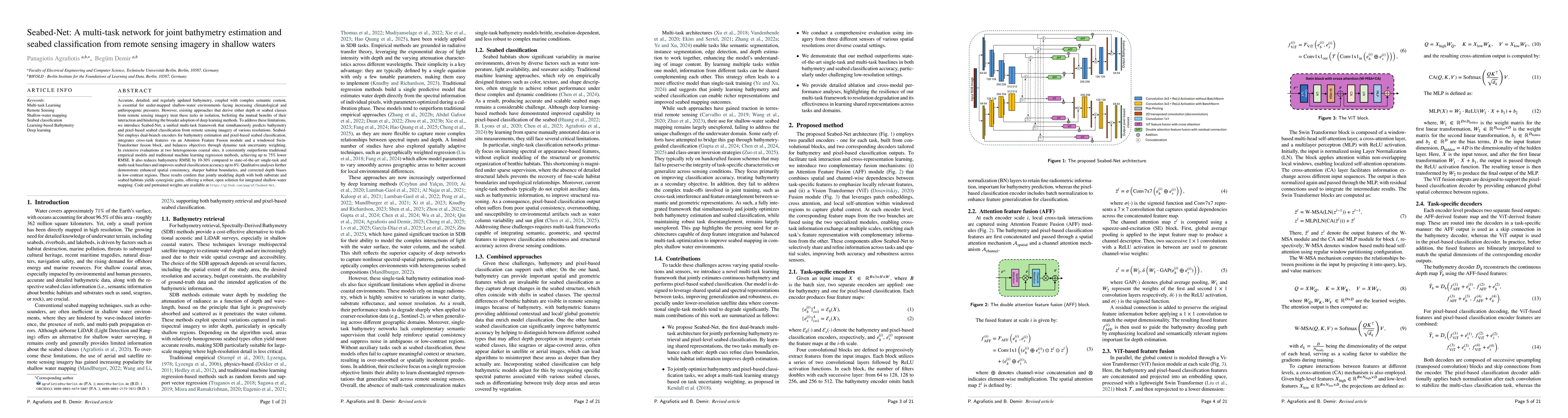
Accurate, detailed, and regularly updated bathymetry, coupled with complex semantic content, is essential for under-mapped shallow-water environments facing increasing climatological and anthropogenic...
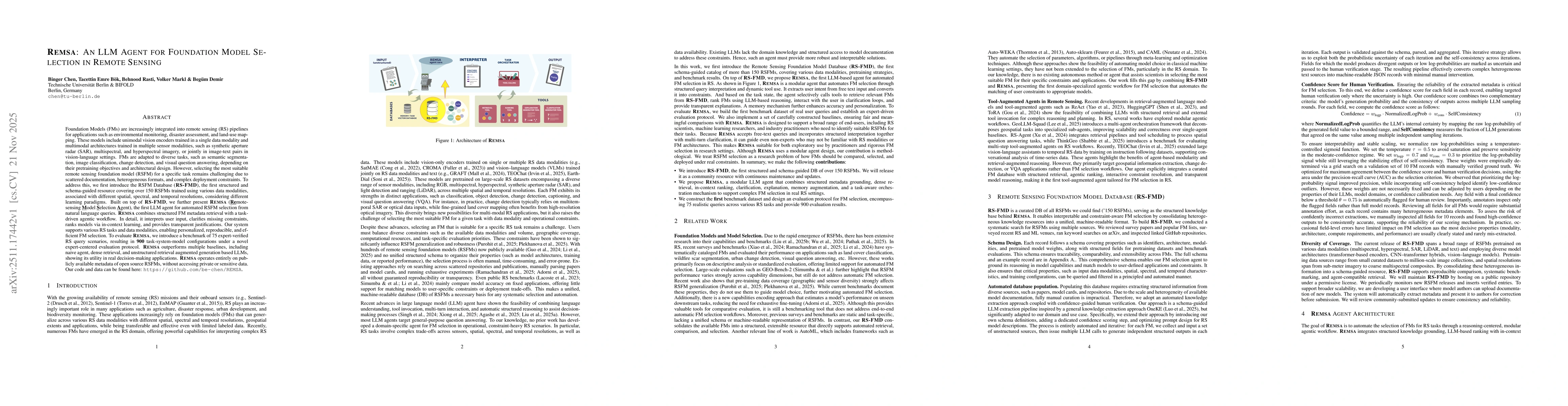
Foundation Models (FMs) are increasingly used in remote sensing (RS) for tasks such as environmental monitoring, disaster assessment, and land-use mapping. These models include unimodal vision encoder...
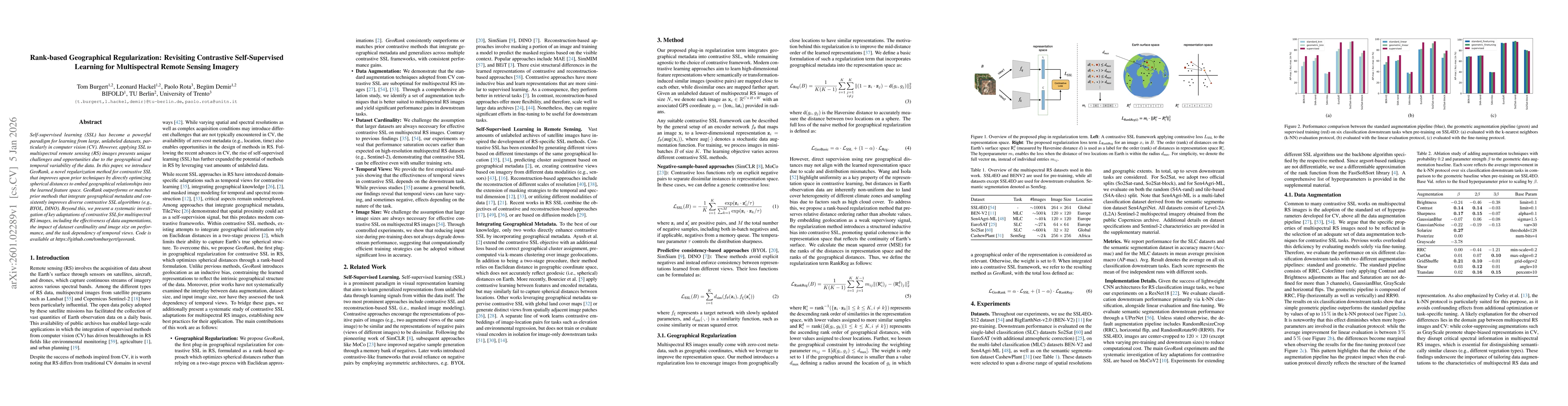
Self-supervised learning (SSL) has become a powerful paradigm for learning from large, unlabeled datasets, particularly in computer vision (CV). However, applying SSL to multispectral remote sensing (...
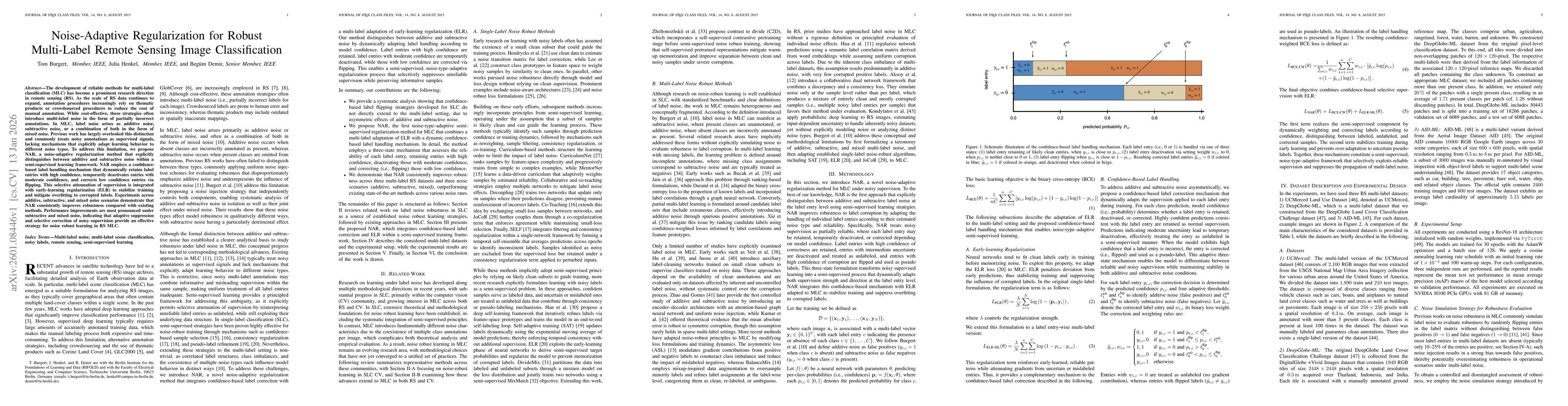
The development of reliable methods for multi-label classification (MLC) has become a prominent research direction in remote sensing (RS). As the scale of RS data continues to expand, annotation proce...
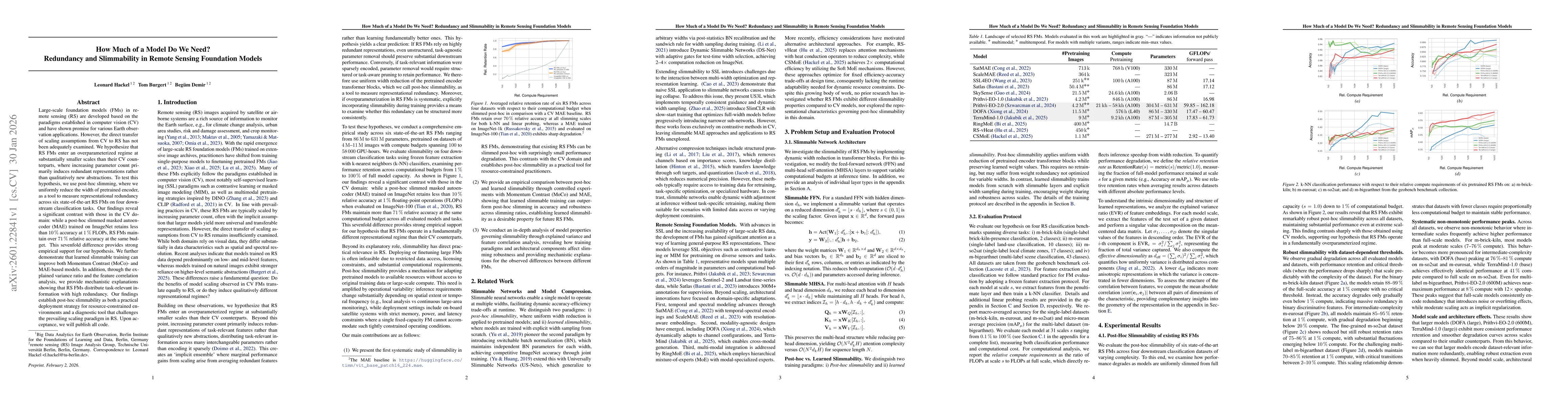
Large-scale foundation models (FMs) in remote sensing (RS) are developed based on the paradigms established in computer vision (CV) and have shown promise for various Earth observation applications. H...
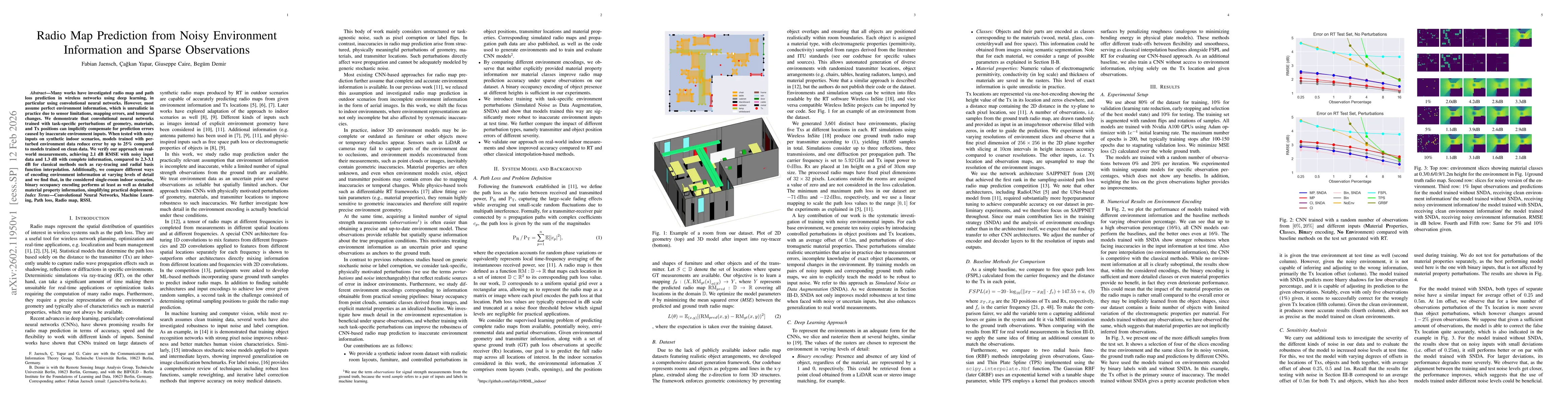
Many works have investigated radio map and path loss prediction in wireless networks using deep learning, in particular using convolutional neural networks. However, most assume perfect environment in...
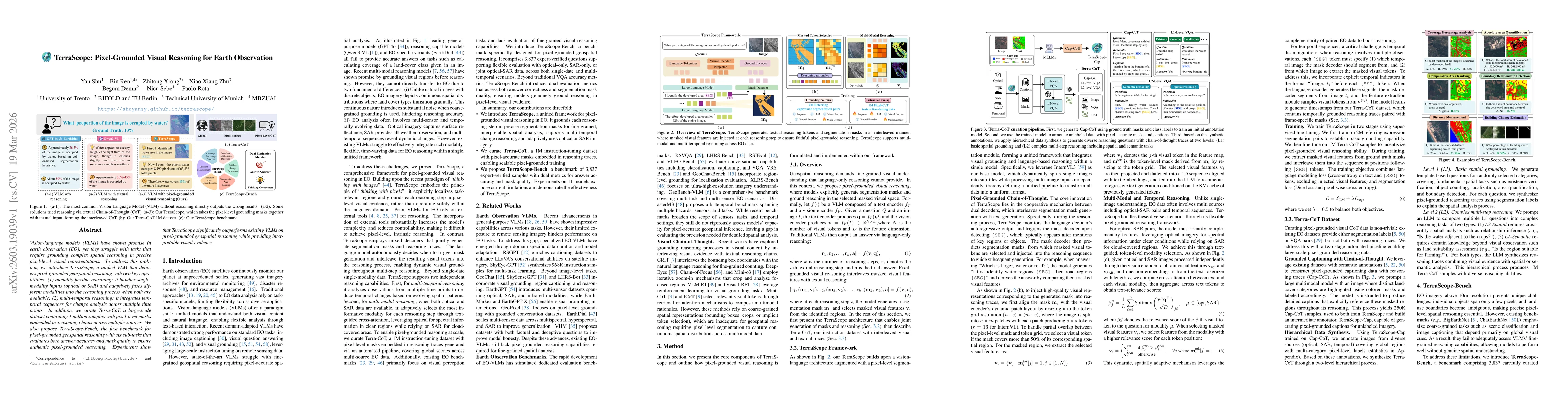
Vision-language models (VLMs) have shown promise in earth observation (EO), yet they struggle with tasks that require grounding complex spatial reasoning in precise pixel-level visual representations....

The rapid growth of hyperspectral data archives in remote sensing (RS) necessitates effective compression methods for storage and transmission. Recent advances in learning-based hyperspectral image (H...
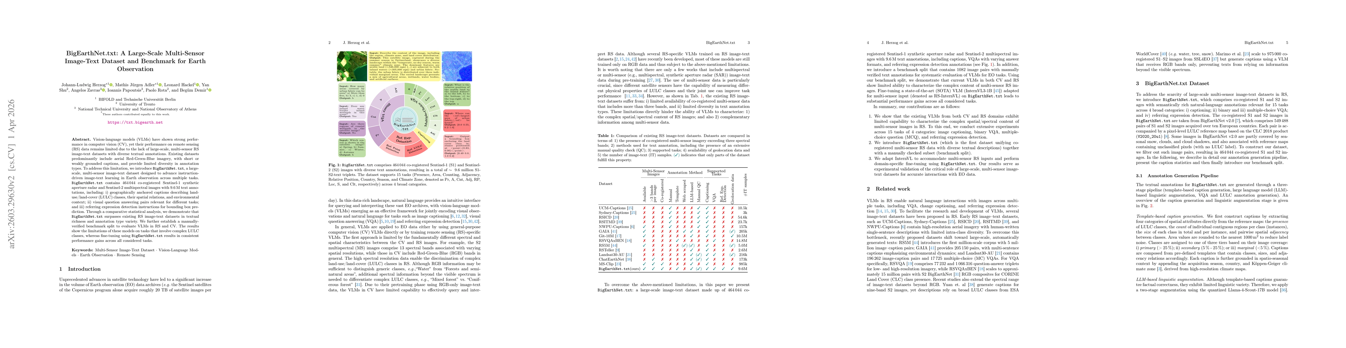
Vision-langugage models (VLMs) have shown strong performance in computer vision (CV), yet their performance on remote sensing (RS) data remains limited due to the lack of large-scale, multi-sensor RS ...
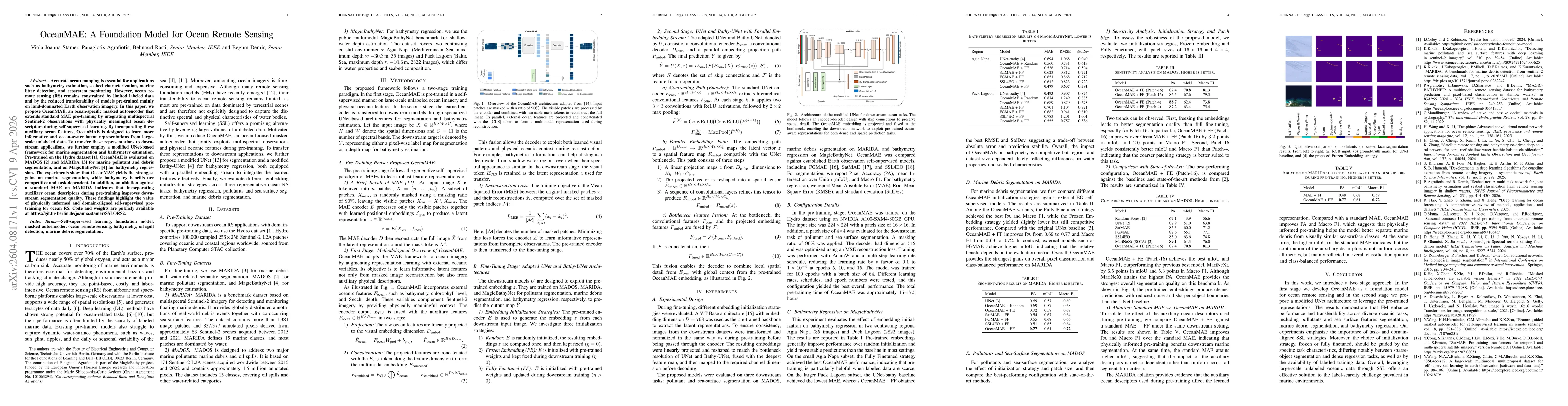
Accurate ocean mapping is essential for applications such as bathymetry estimation, seabed characterization, marine litter detection, and ecosystem monitoring. However, ocean remote sensing (RS) remai...
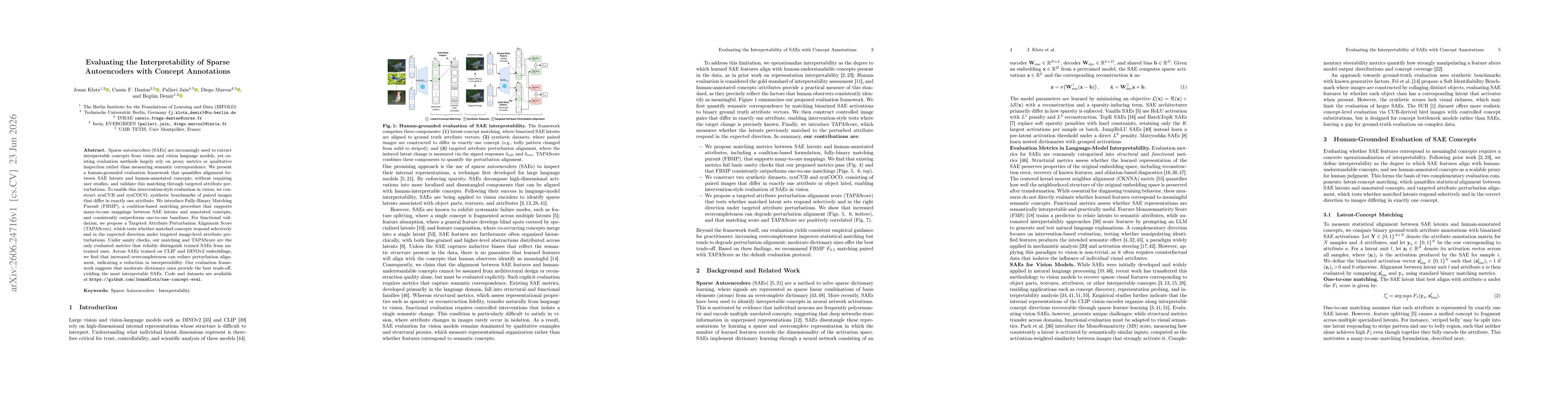
Sparse autoencoders (SAEs) are increasingly used to extract interpretable concepts from vision and vision language models, yet existing evaluation methods largely rely on proxy metrics or qualitative ...