Academic Profile
Statistics
Similar Authors
Papers on arXiv
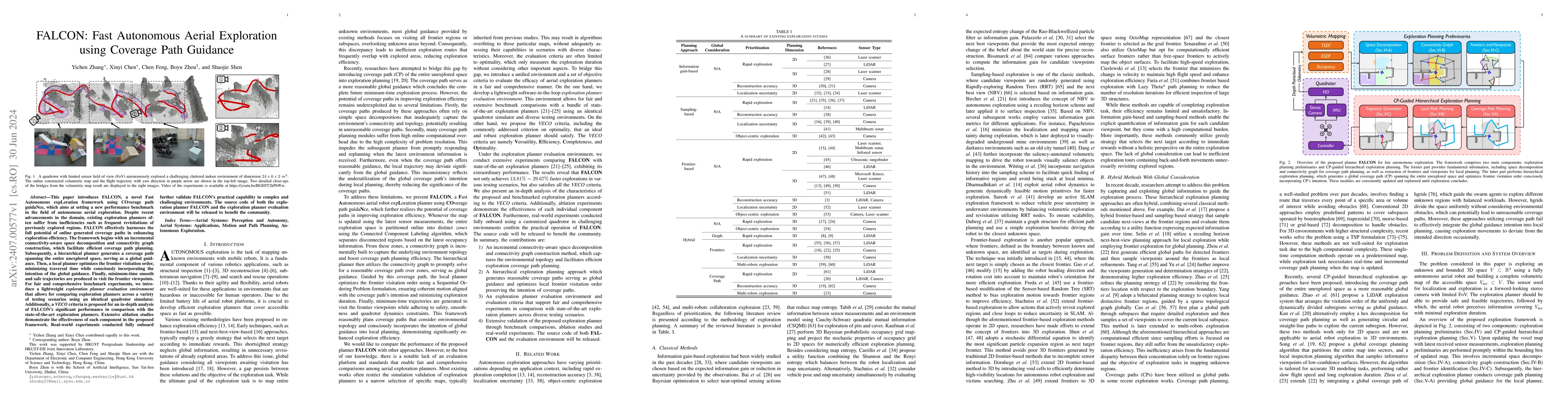
This paper introduces FALCON, a novel Fast Autonomous expLoration framework using COverage path guidaNce, which aims at setting a new performance benchmark in the field of autonomous aerial explorat...
Surface prediction and completion have been widely studied in various applications. Recently, research in surface completion has evolved from small objects to complex large-scale scenes. As a result...
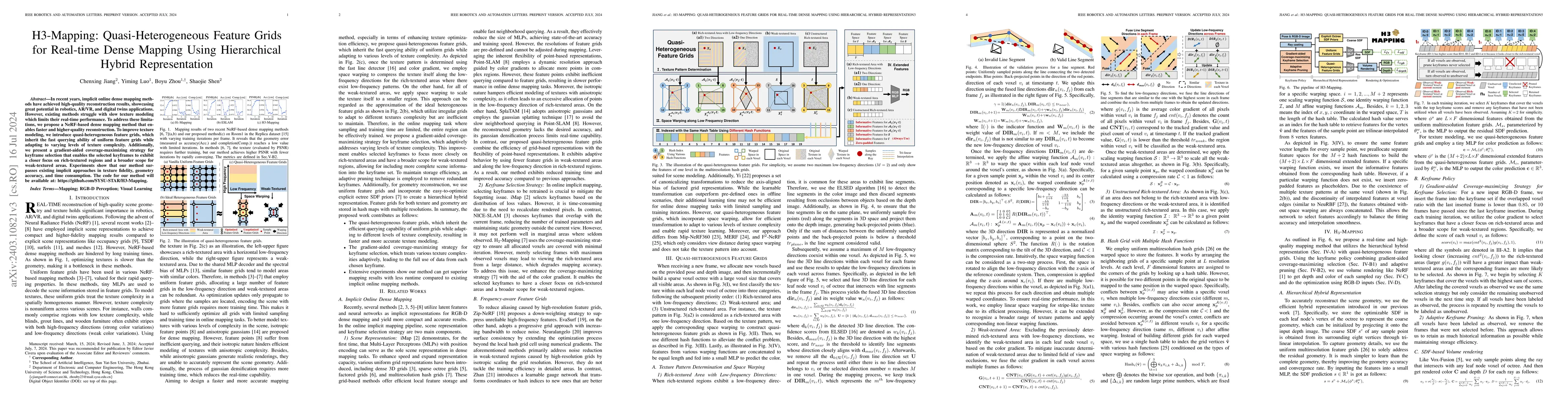
In recent years, implicit online dense mapping methods have achieved high-quality reconstruction results, showcasing great potential in robotics, AR/VR, and digital twins applications. However, exis...
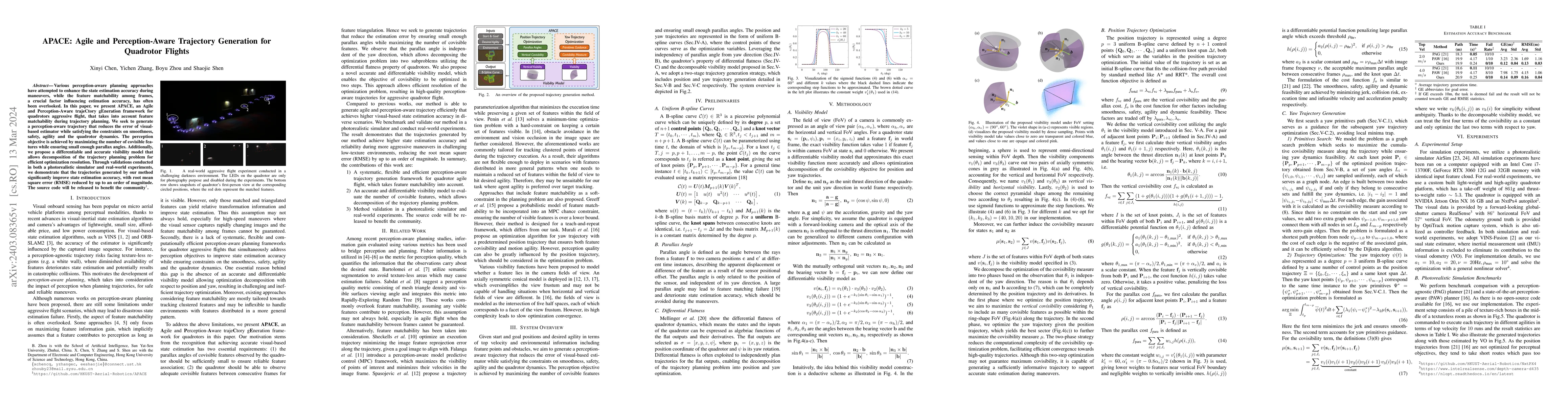
Various perception-aware planning approaches have attempted to enhance the state estimation accuracy during maneuvers, while the feature matchability among frames, a crucial factor influencing estim...
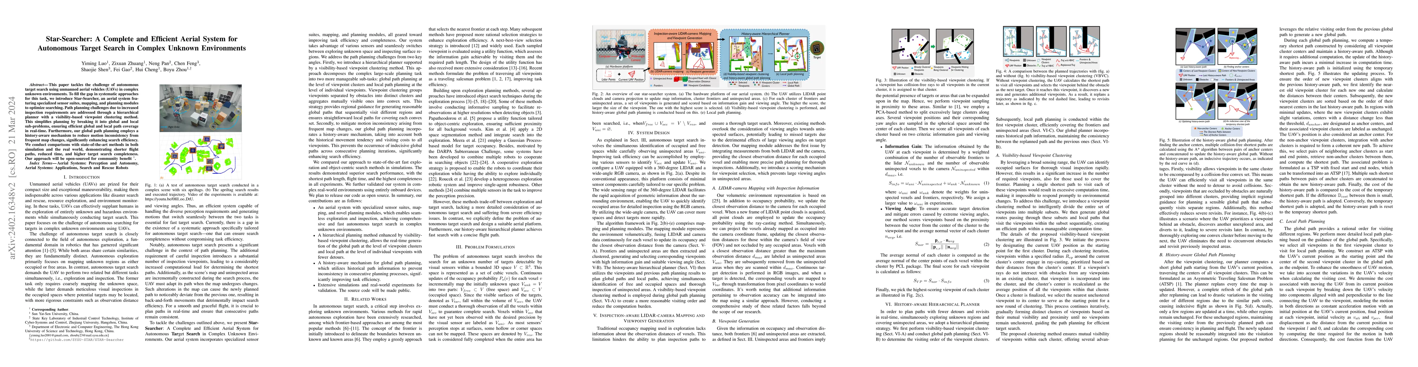
This paper tackles the challenge of autonomous target search using unmanned aerial vehicles (UAVs) in complex unknown environments. To fill the gap in systematic approaches for this task, we introdu...
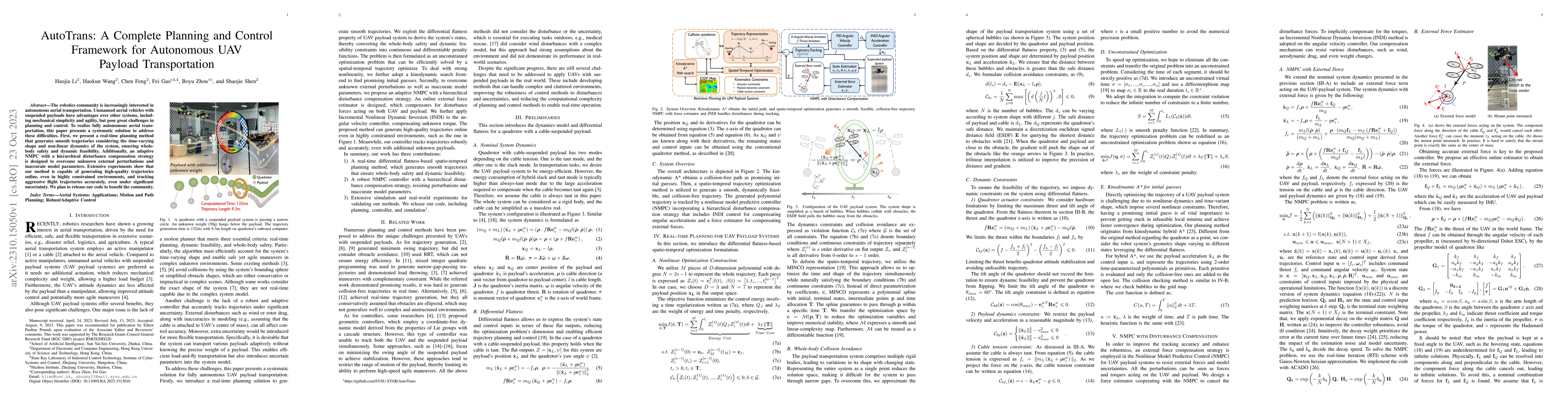
The robotics community is increasingly interested in autonomous aerial transportation. Unmanned aerial vehicles with suspended payloads have advantages over other systems, including mechanical simpl...
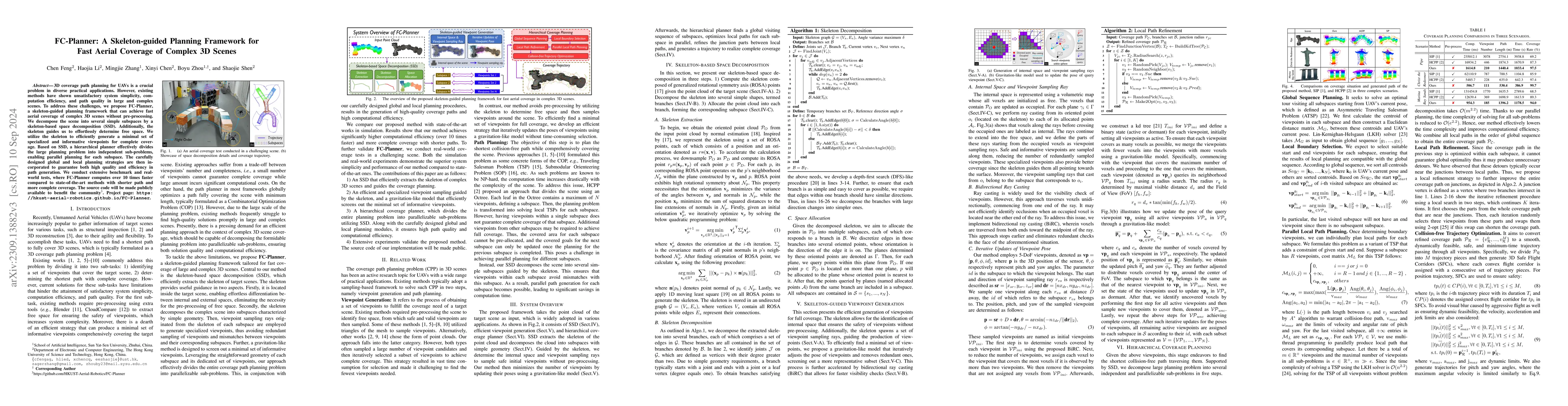
3D coverage path planning for UAVs is a crucial problem in diverse practical applications. However, existing methods have shown unsatisfactory system simplicity, computation efficiency, and path qua...
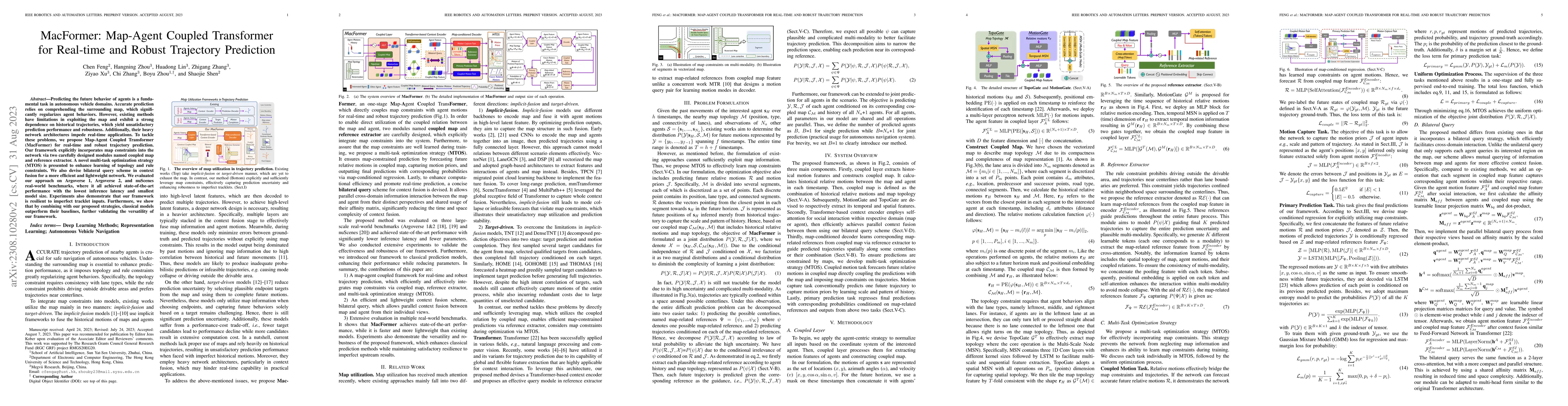
Predicting the future behavior of agents is a fundamental task in autonomous vehicle domains. Accurate prediction relies on comprehending the surrounding map, which significantly regularizes agent b...
We consider the generic form of a two-mode bosonic state $|\Psi_n\rangle$ with finite Fock expansion and fixed mean photon number to an integer $n\geq1$. The upper and lower modes of the input state...
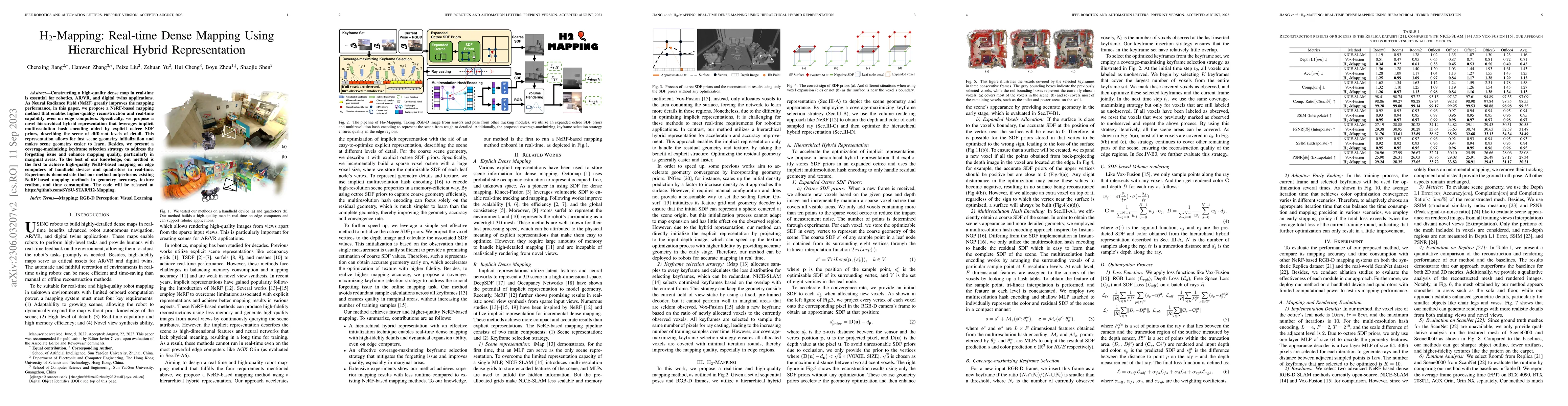
Constructing a high-quality dense map in real-time is essential for robotics, AR/VR, and digital twins applications. As Neural Radiance Field (NeRF) greatly improves the mapping performance, in this...
We address the problem of estimating the transmissivity of the pure-loss channel from the Bayesian point of view, i.e., we consider that some prior probability distribution function (PDF) on the unk...
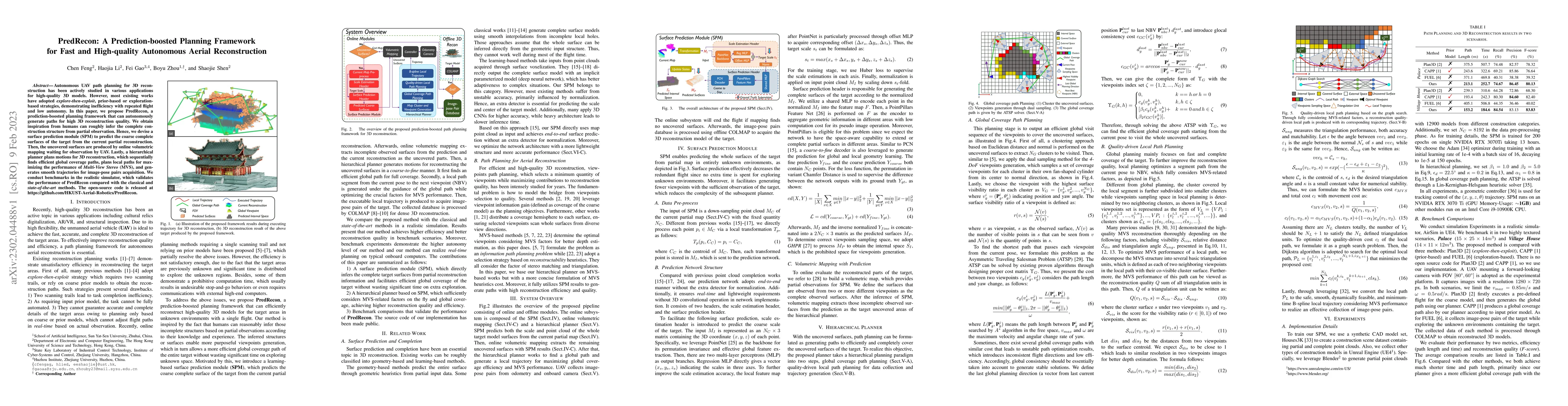
Autonomous UAV path planning for 3D reconstruction has been actively studied in various applications for high-quality 3D models. However, most existing works have adopted explore-then-exploit, prior...
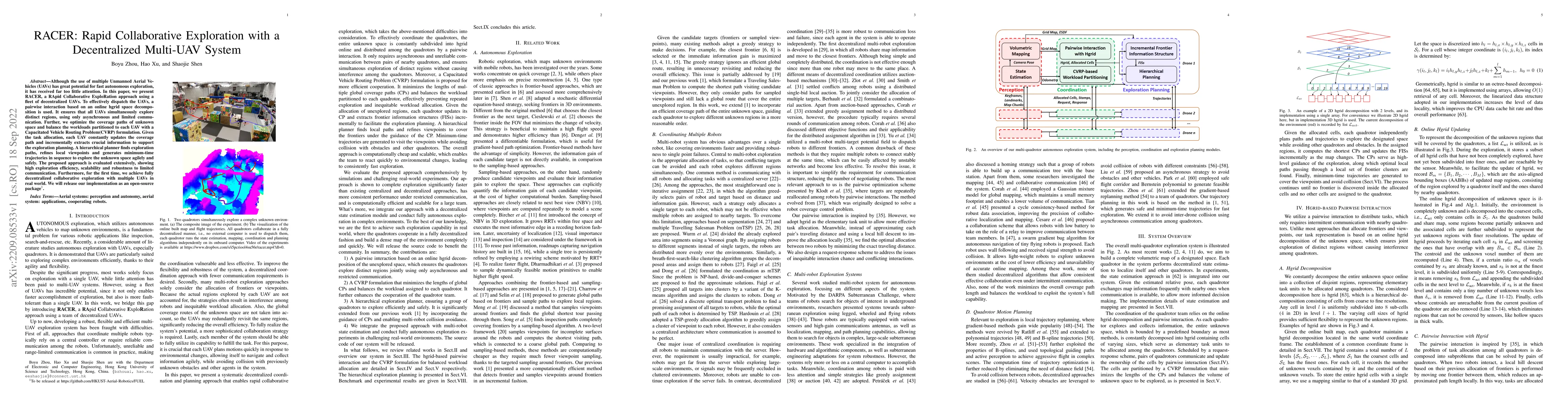
Although the use of multiple Unmanned Aerial Vehicles (UAVs) has great potential for fast autonomous exploration, it has received far too little attention. In this paper, we present RACER, a RApid C...
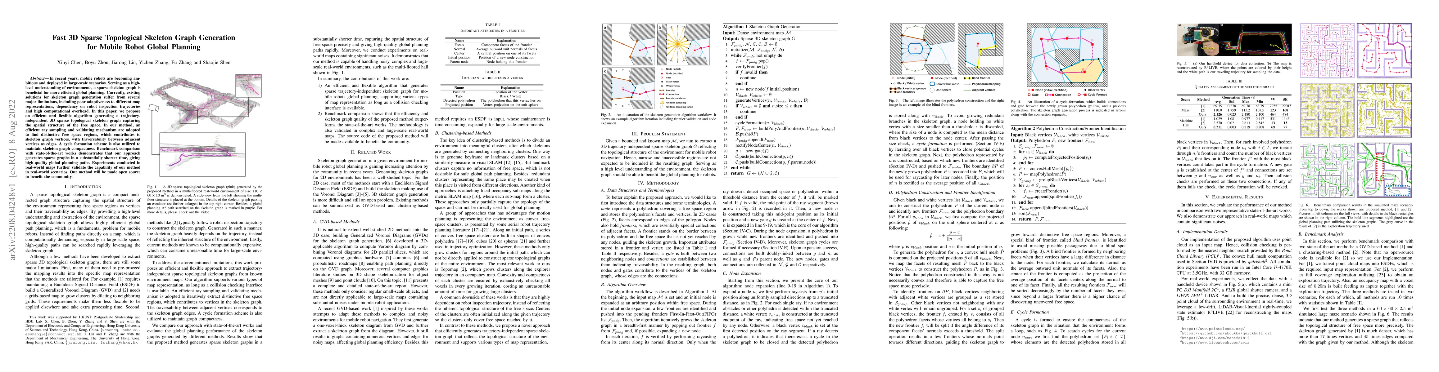
In recent years, mobile robots are becoming ambitious and deployed in large-scale scenarios. Serving as a high-level understanding of environments, a sparse skeleton graph is beneficial for more eff...
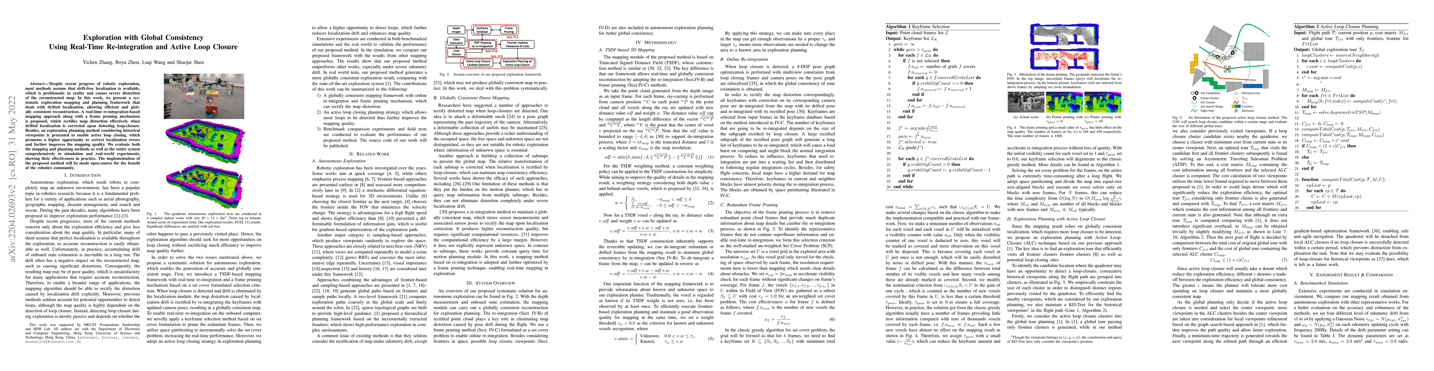
Despite recent progress of robotic exploration, most methods assume that drift-free localization is available, which is problematic in reality and causes severe distortion of the reconstructed map. ...
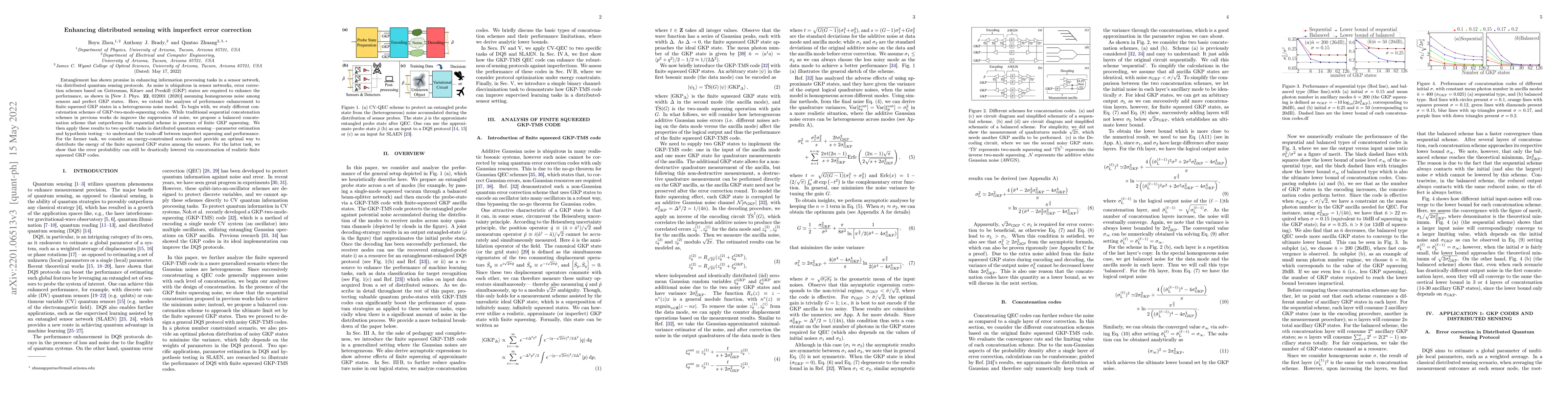
Entanglement has shown promise in enhancing information processing tasks in a sensor network, via distributed quantum sensing protocols. As noise is ubiquitous in sensor networks, error correction s...
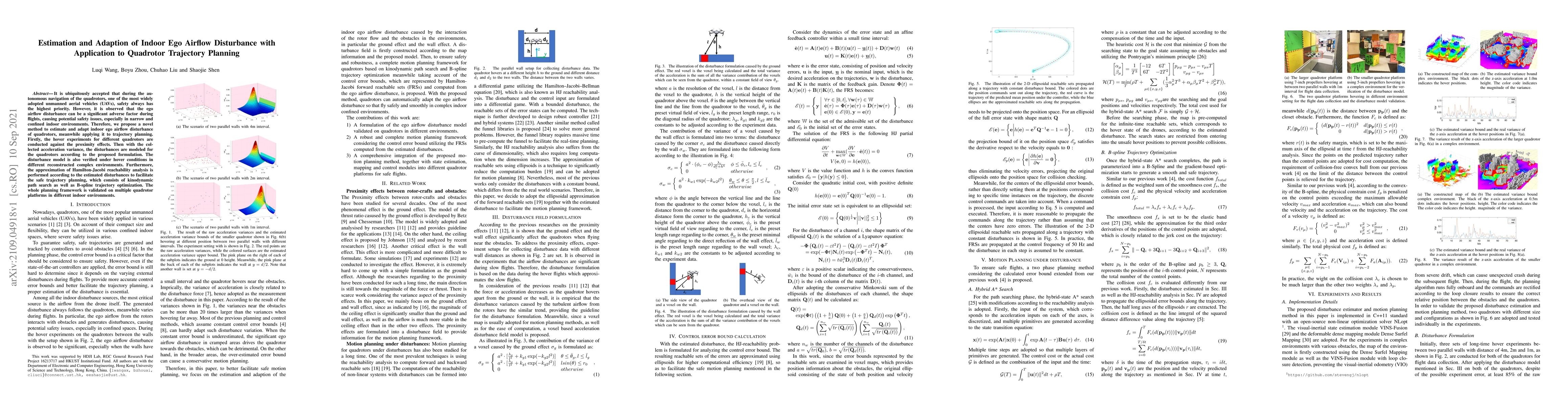
It is ubiquitously accepted that during the autonomous navigation of the quadrotors, one of the most widely adopted unmanned aerial vehicles (UAVs), safety always has the highest priority. However, ...
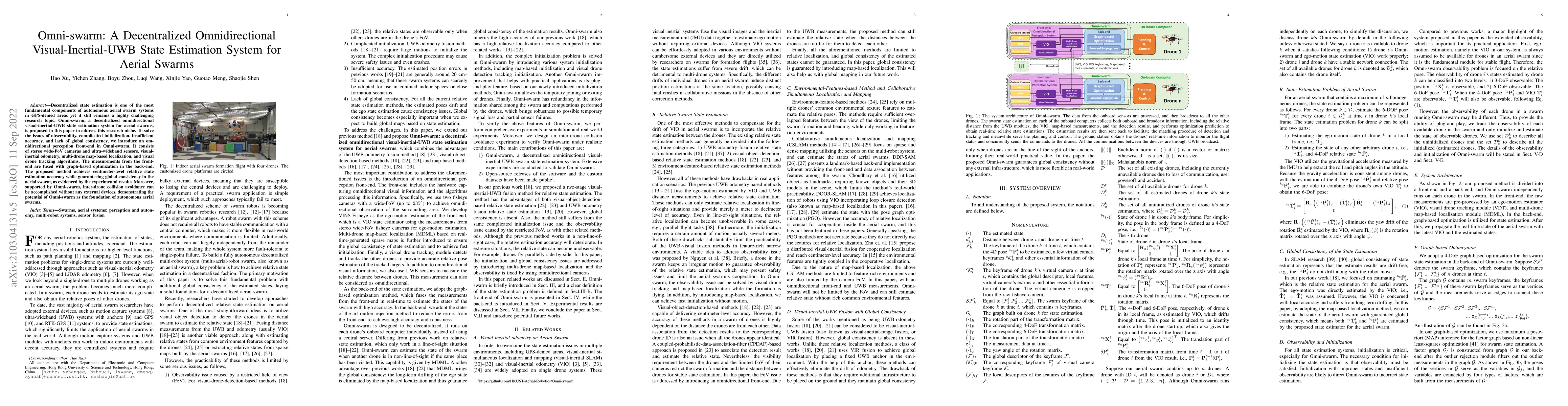
Decentralized state estimation is one of the most fundamental components of autonomous aerial swarm systems in GPS-denied areas yet it still remains a highly challenging research topic. Omni-swarm, ...
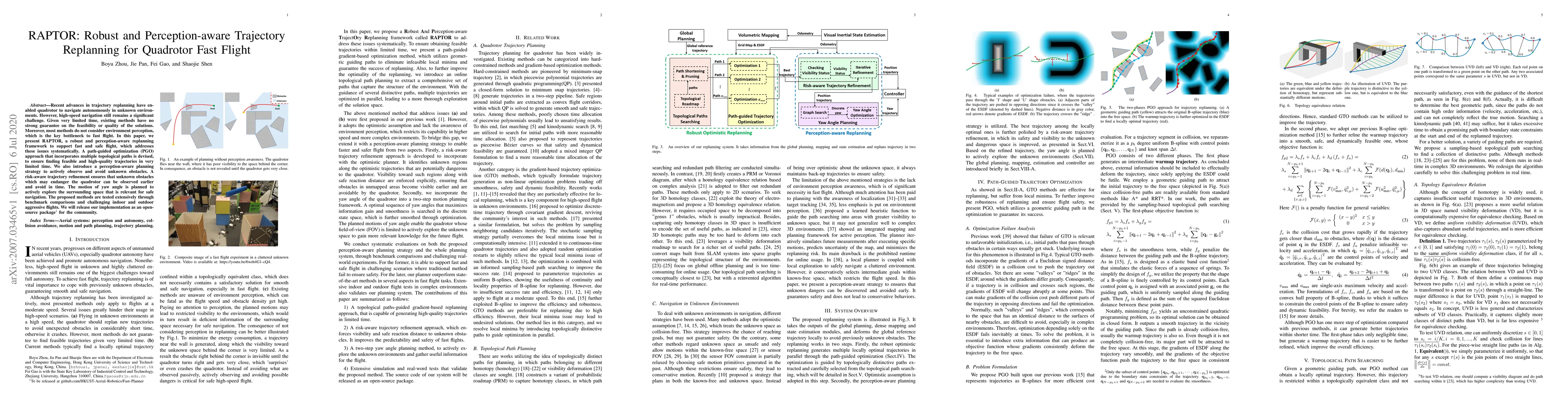
Recent advances in trajectory replanning have enabled quadrotor to navigate autonomously in unknown environments. However, high-speed navigation still remains a significant challenge. Given very lim...
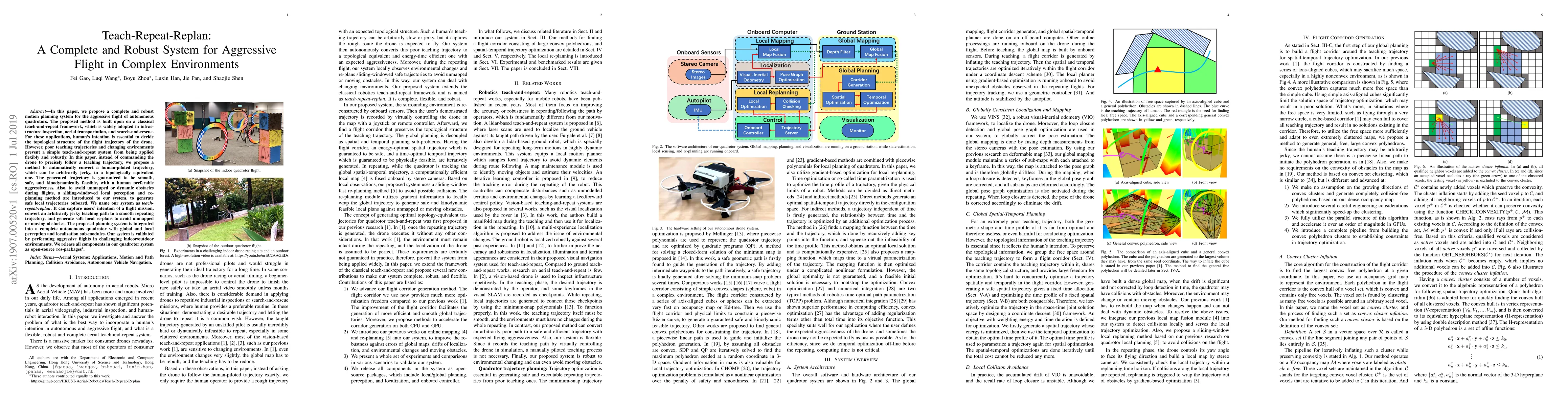
In this paper, we propose a complete and robust motion planning system for the aggressive flight of autonomous quadrotors. The proposed method is built upon on a classical teach-and-repeat framework...
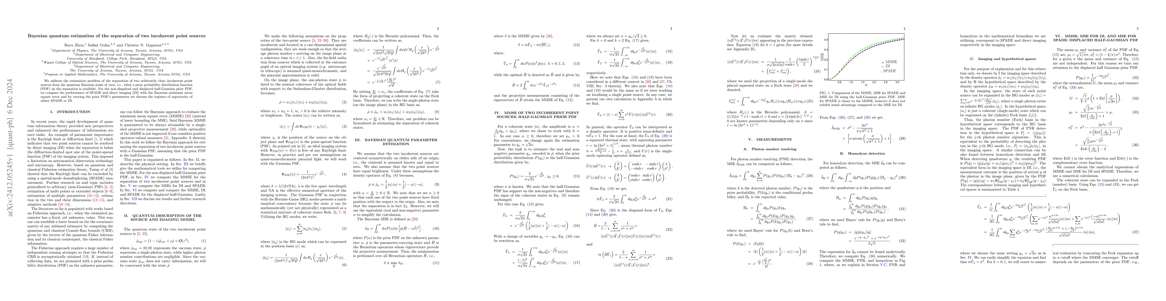
We address the estimation problem of the separation of two arbitrarily close incoherent point sources from the quantum Bayesian point of view, i.e., when a prior probability distribution function (PDF...
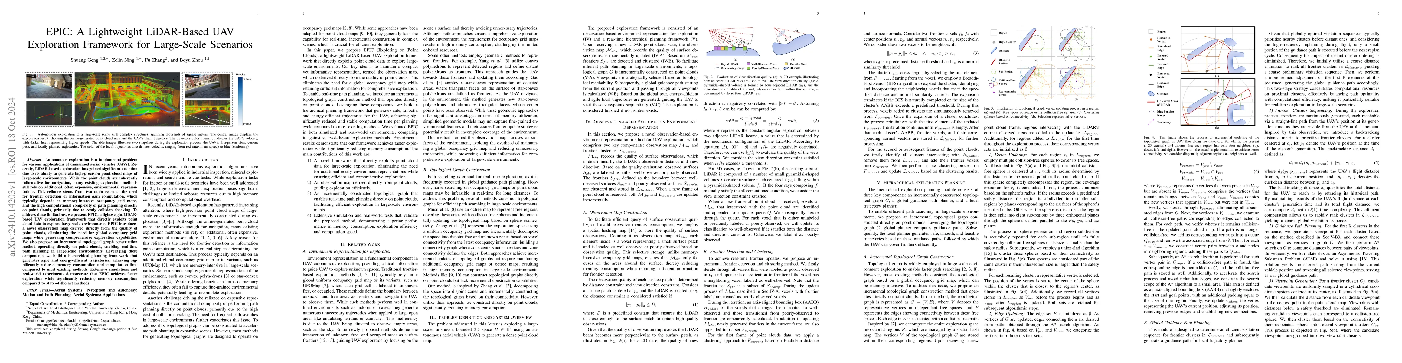
Autonomous exploration is a fundamental problem for various applications of unmanned aerial vehicles (UAVs). Recently, LiDAR-based exploration has gained significant attention due to its ability to ge...
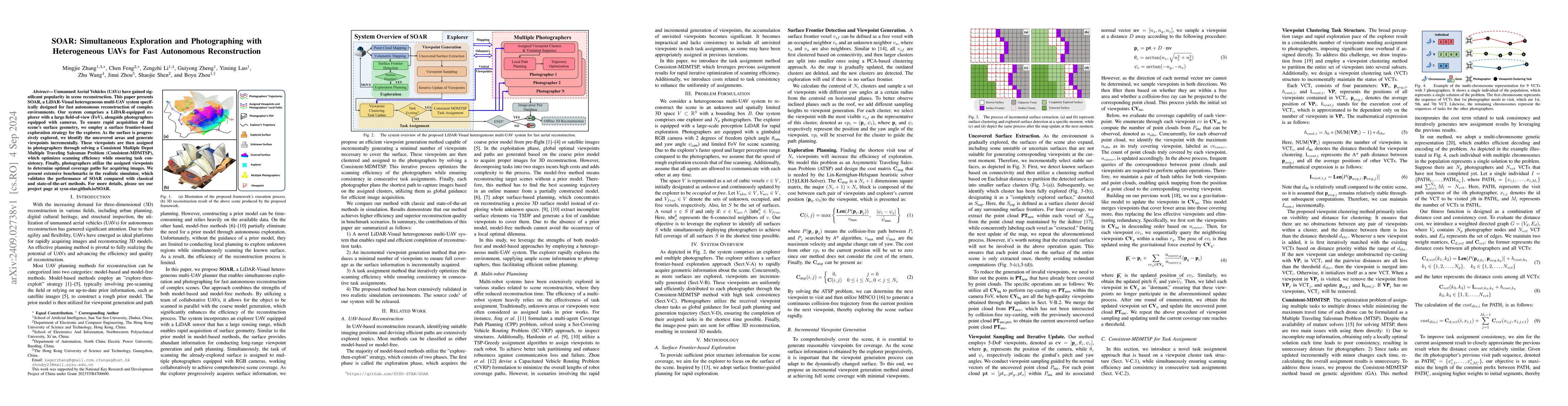
Unmanned Aerial Vehicles (UAVs) have gained significant popularity in scene reconstruction. This paper presents SOAR, a LiDAR-Visual heterogeneous multi-UAV system specifically designed for fast auton...
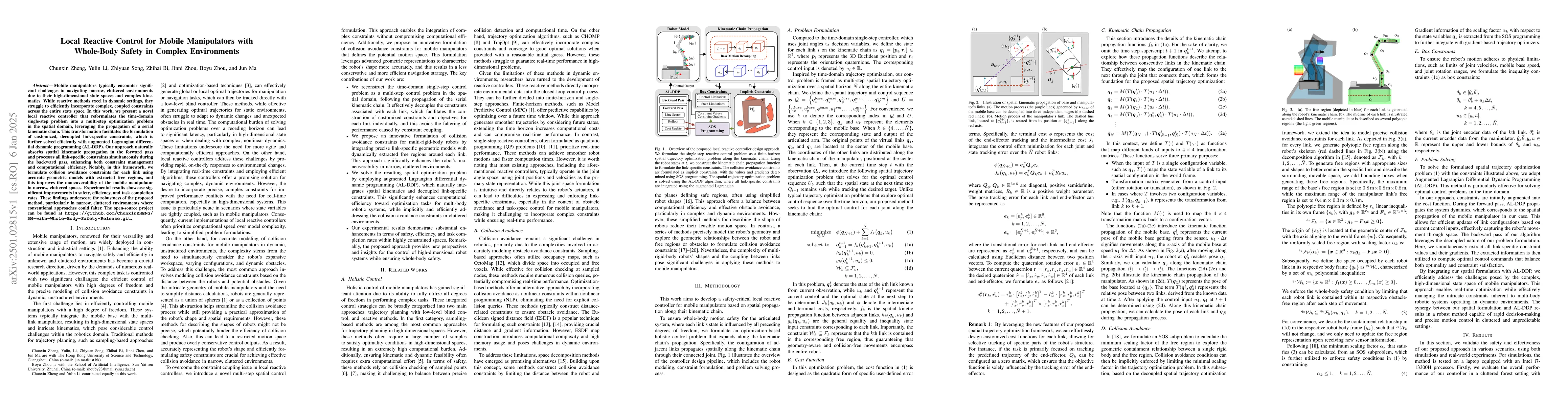
Mobile manipulators typically encounter significant challenges in navigating narrow, cluttered environments due to their high-dimensional state spaces and complex kinematics. While reactive methods ex...
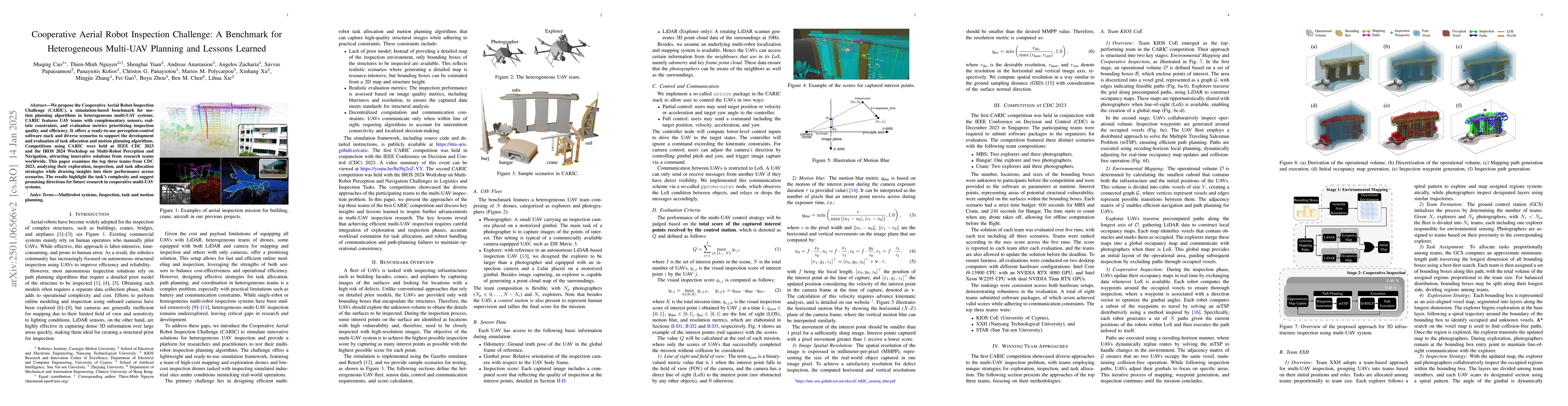
We propose the Cooperative Aerial Robot Inspection Challenge (CARIC), a simulation-based benchmark for motion planning algorithms in heterogeneous multi-UAV systems. CARIC features UAV teams with comp...
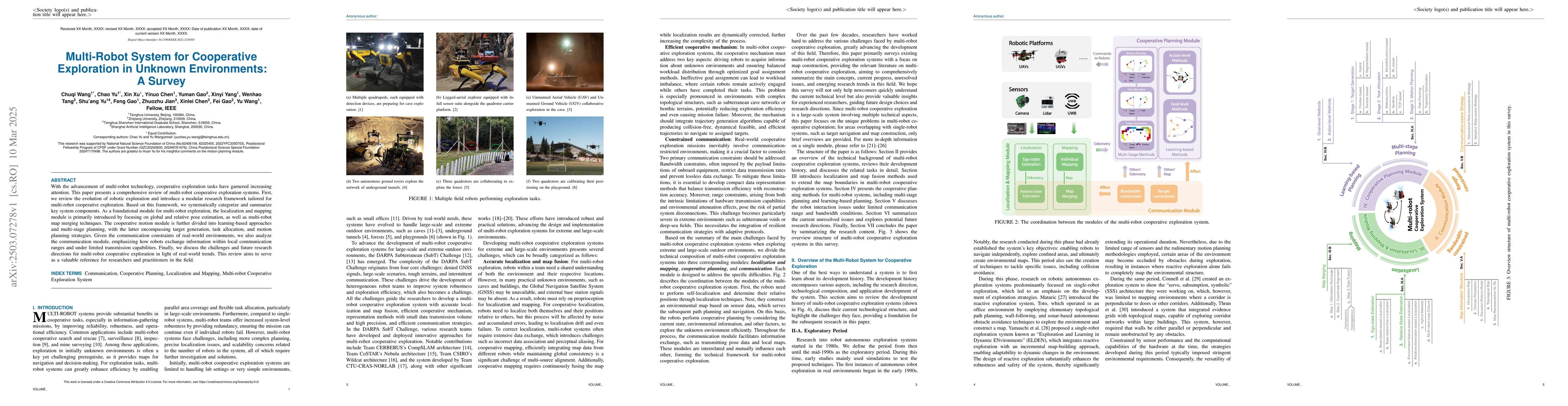
With the advancement of multi-robot technology, cooperative exploration tasks have garnered increasing attention. This paper presents a comprehensive review of multi-robot cooperative exploration syst...
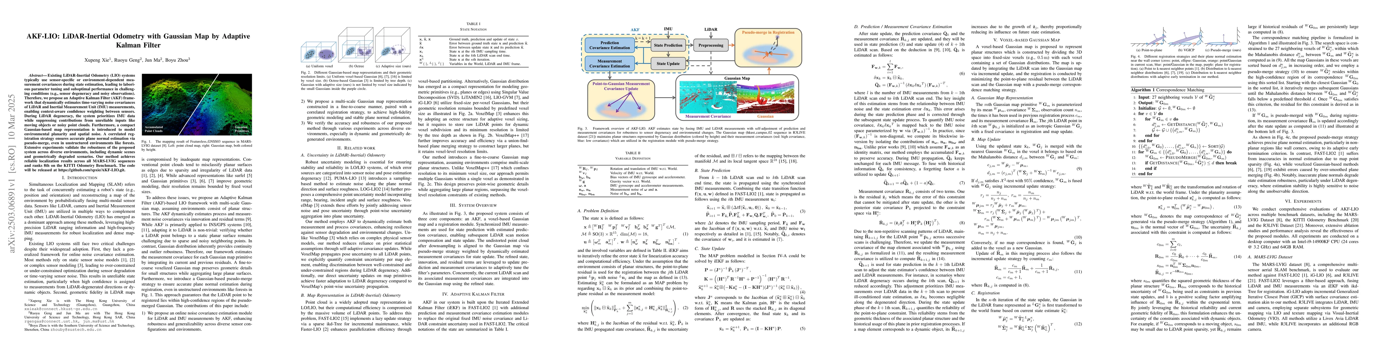
Existing LiDAR-Inertial Odometry (LIO) systems typically use sensor-specific or environment-dependent measurement covariances during state estimation, leading to laborious parameter tuning and subopti...
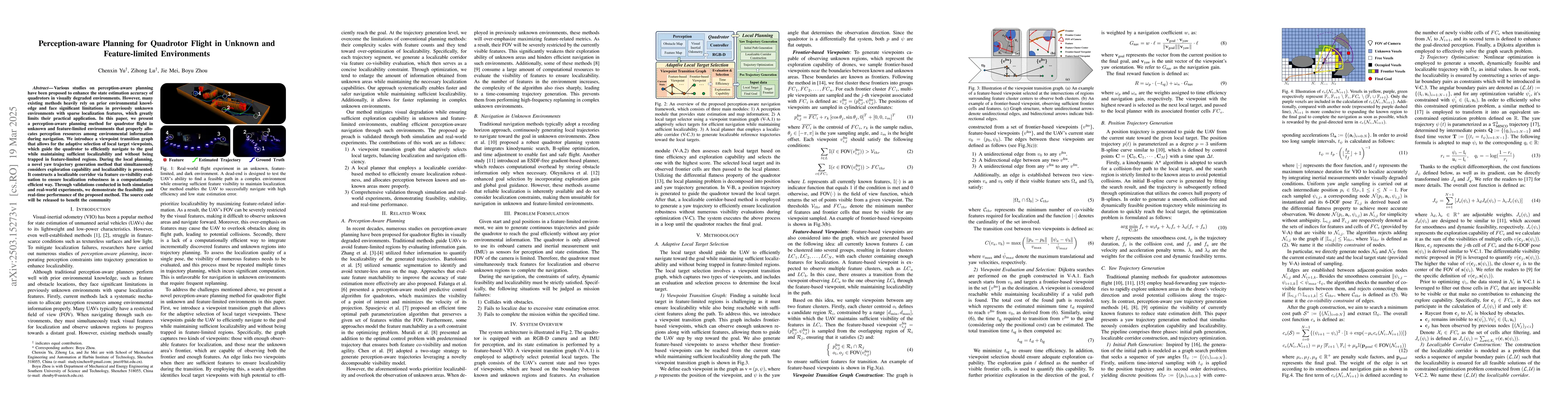
Various studies on perception-aware planning have been proposed to enhance the state estimation accuracy of quadrotors in visually degraded environments. However, many existing methods heavily rely on...
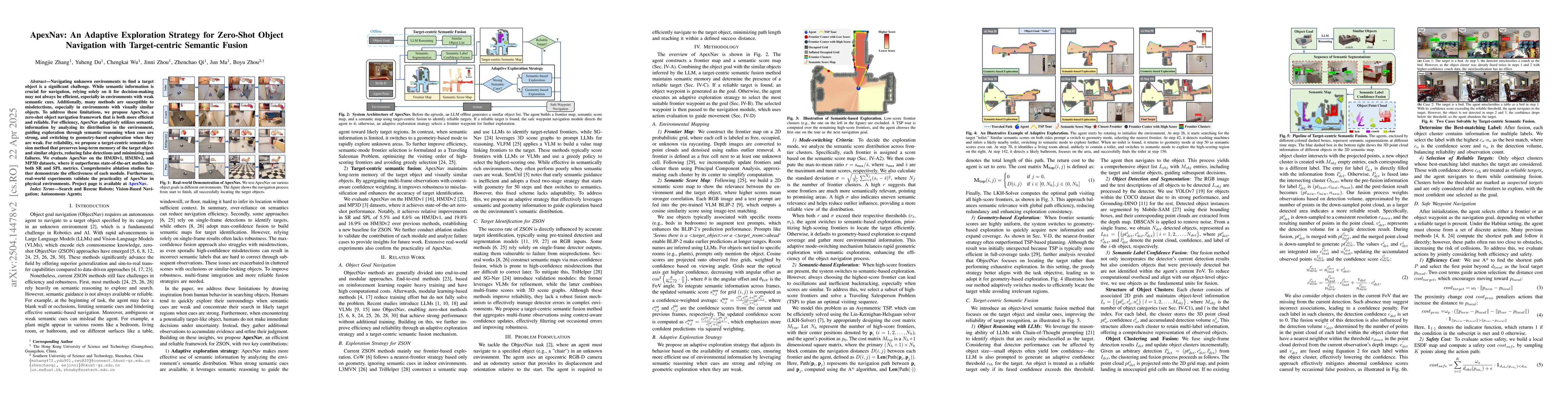
Navigating unknown environments to find a target object is a significant challenge. While semantic information is crucial for navigation, relying solely on it for decision-making may not always be eff...
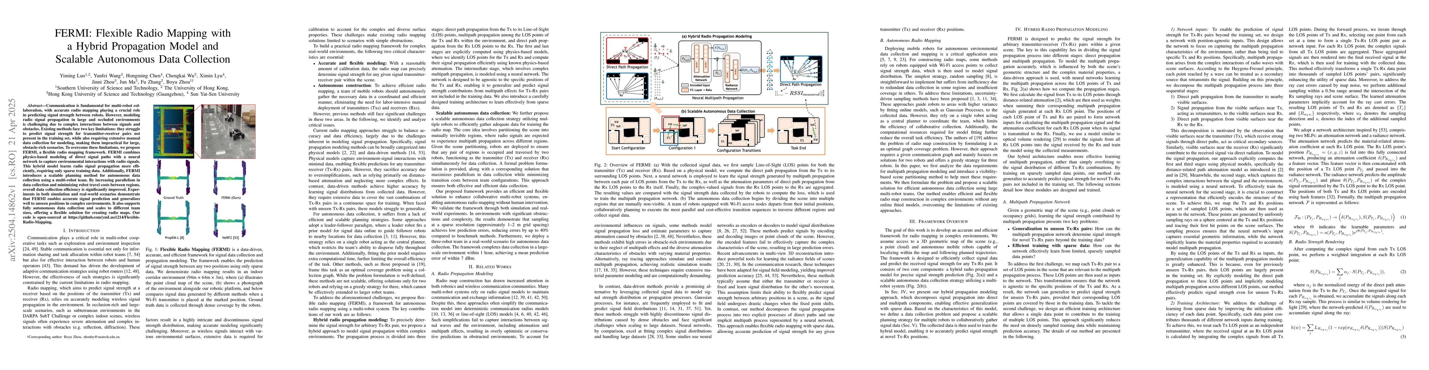
Communication is fundamental for multi-robot collaboration, with accurate radio mapping playing a crucial role in predicting signal strength between robots. However, modeling radio signal propagation ...
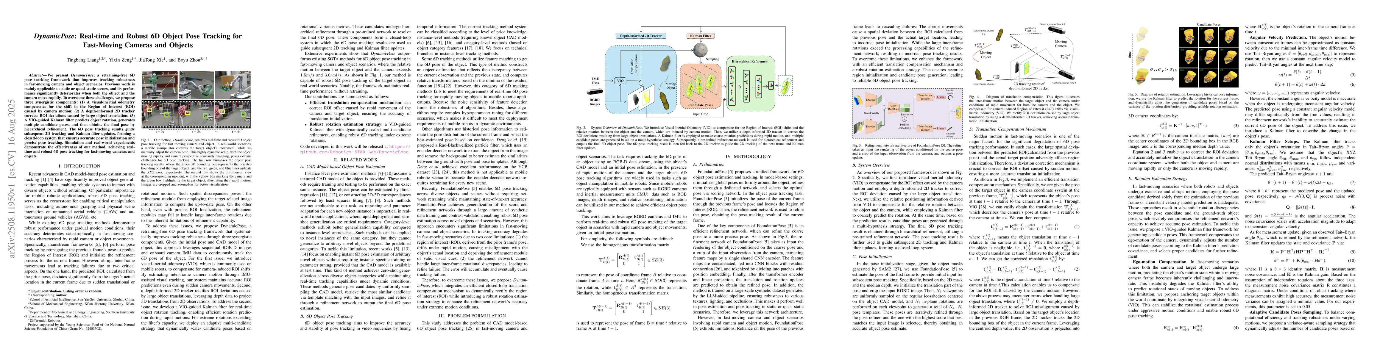
We present DynamicPose, a retraining-free 6D pose tracking framework that improves tracking robustness in fast-moving camera and object scenarios. Previous work is mainly applicable to static or quasi...
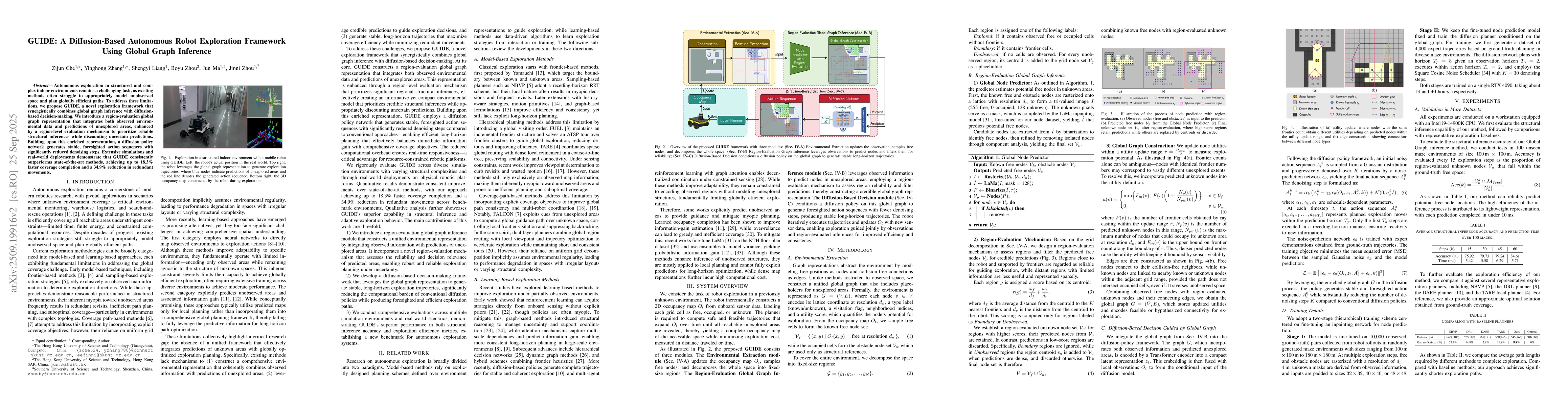
Autonomous exploration in structured and complex indoor environments remains a challenging task, as existing methods often struggle to appropriately model unobserved space and plan globally efficient ...
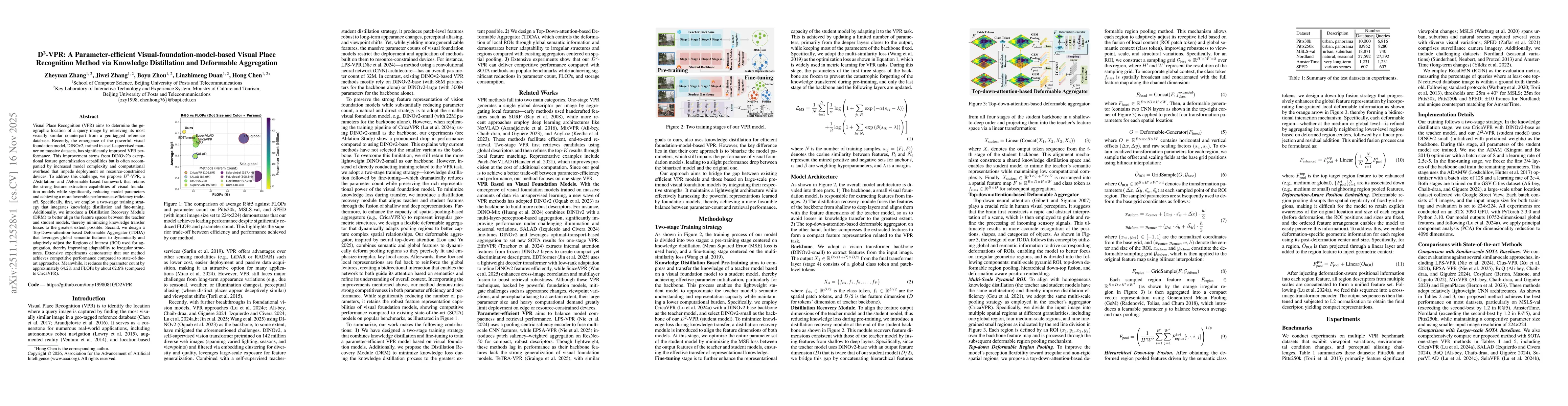
Visual Place Recognition (VPR) aims to determine the geographic location of a query image by retrieving its most visually similar counterpart from a geo-tagged reference database. Recently, the emerge...
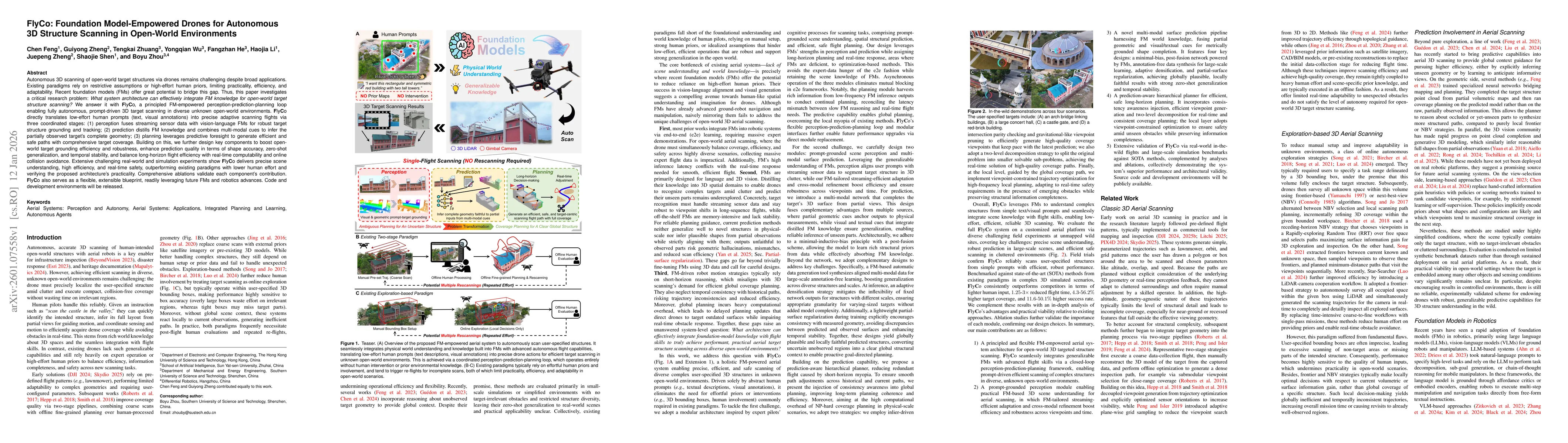
Autonomous 3D scanning of open-world target structures via drones remains challenging despite broad applications. Existing paradigms rely on restrictive assumptions or effortful human priors, limiting...
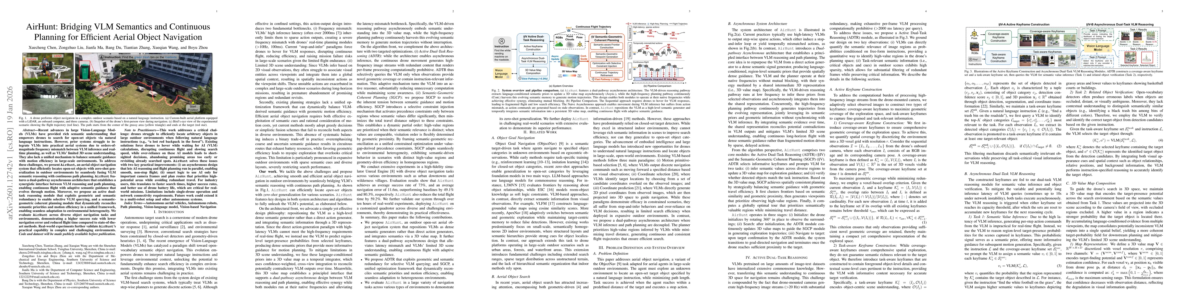
Recent advances in large Vision-Language Models (VLMs) have provided rich semantic understanding that empowers drones to search for open-set objects via natural language instructions. However, prior s...
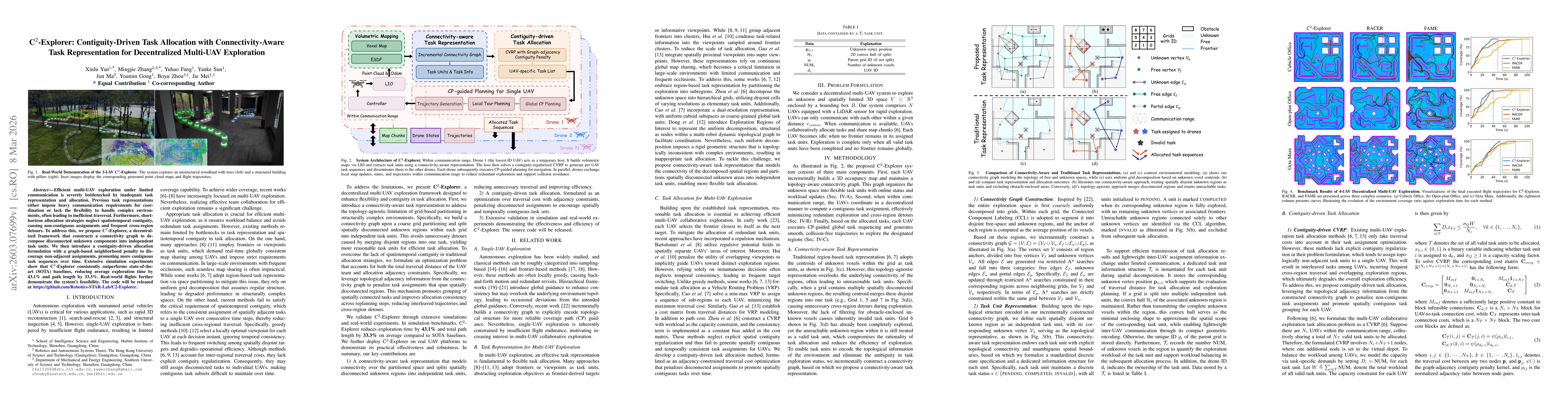
Efficient multi-UAV exploration under limited communication is severely bottlenecked by inadequate task representation and allocation. Previous task representations either impose heavy communication r...
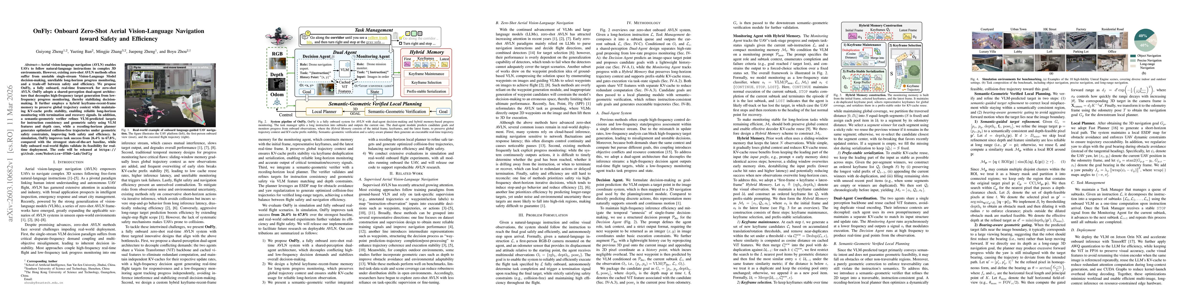
Aerial vision-language navigation (AVLN) enables UAVs to follow natural-language instructions in complex 3D environments. However, existing zero-shot AVLN methods often suffer from unstable single-str...
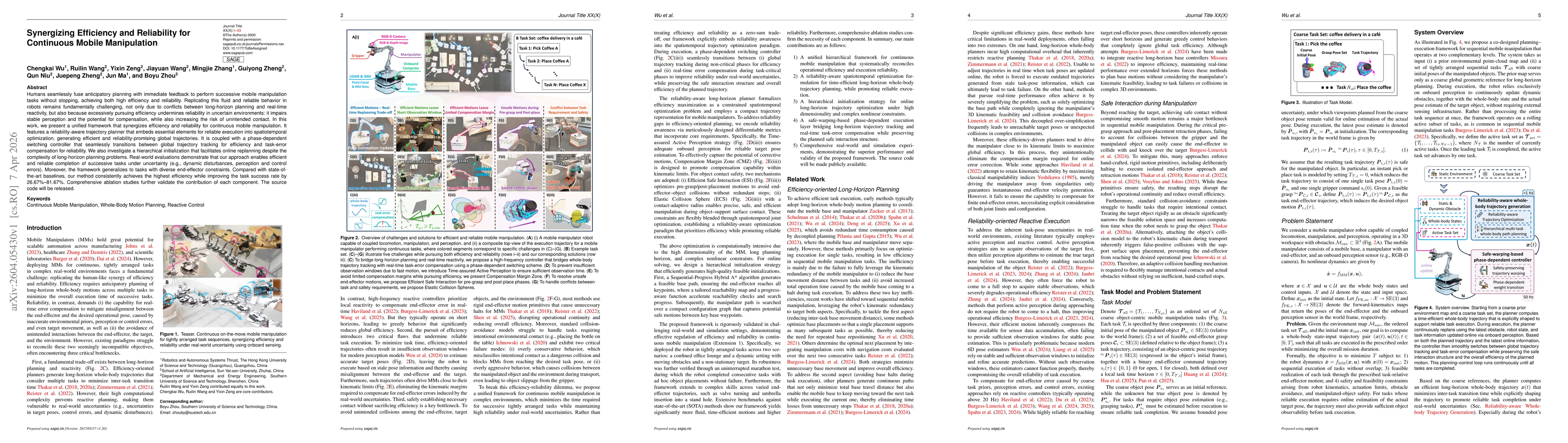
Humans seamlessly fuse anticipatory planning with immediate feedback to perform successive mobile manipulation tasks without stopping, achieving both high efficiency and reliability. Replicating this ...
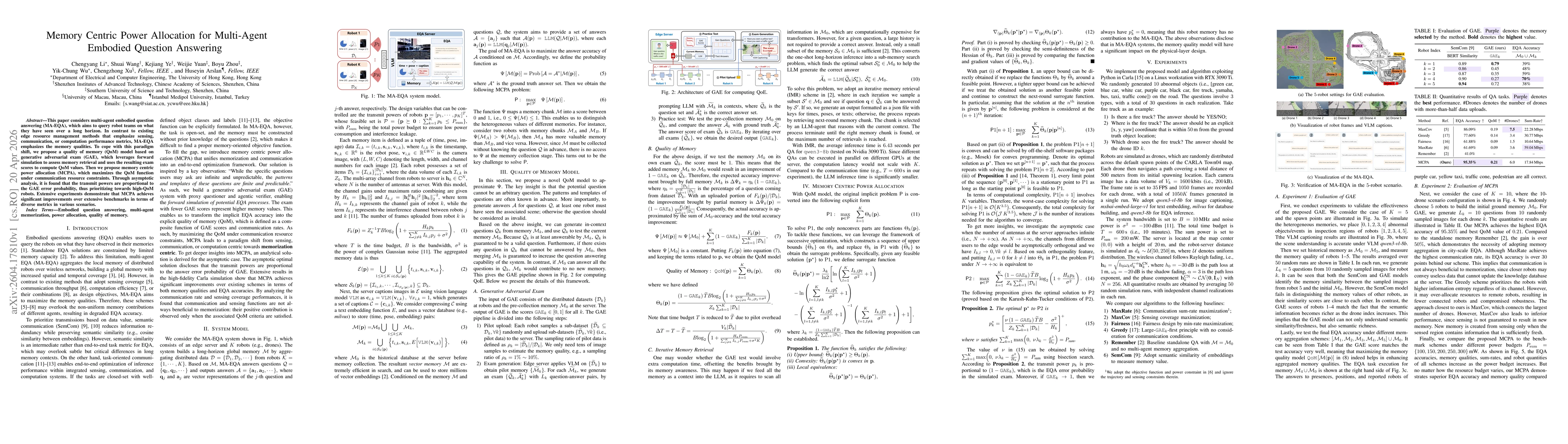
This paper considers multi-agent embodied question answering (MA-EQA), which aims to query robot teams on what they have seen over a long horizon. In contrast to existing edge resource management meth...
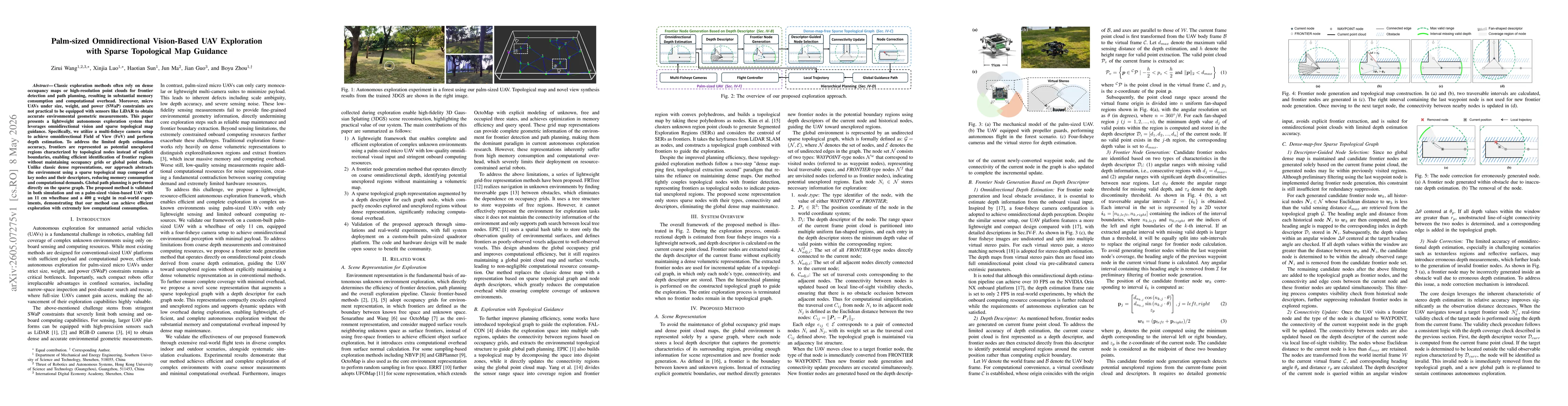
Classic exploration methods often rely on dense occupancy maps or high-resolution point clouds for frontier detection and path planning, resulting in substantial memory consumption and computational o...
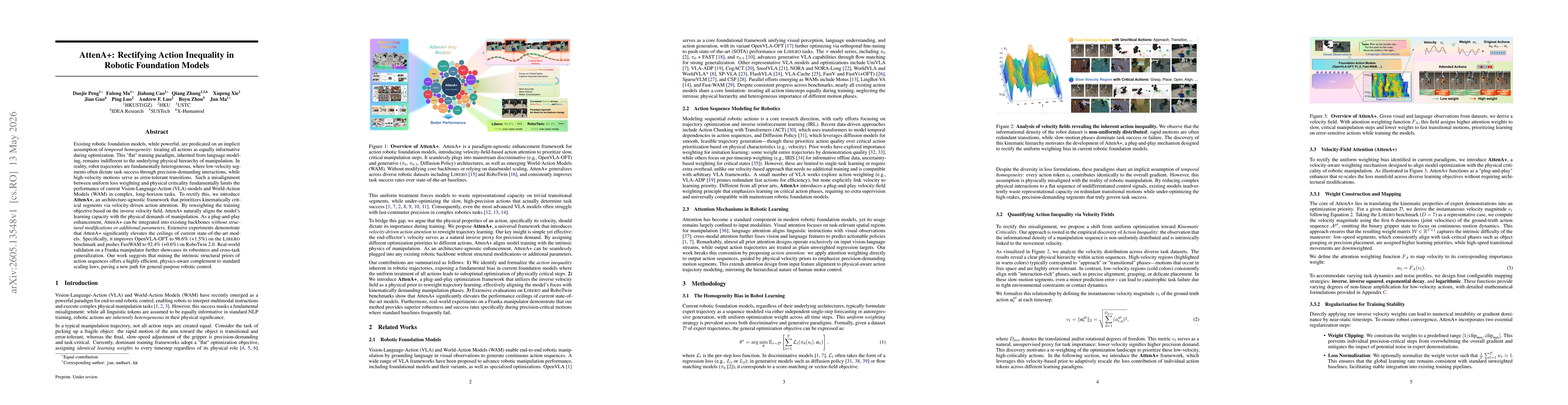
Existing robotic foundation models, while powerful, are predicated on an implicit assumption of temporal homogeneity: treating all actions as equally informative during optimization. This "flat" train...
Efficient UAV exploration in unknown environments requires rapid coverage expansion while maintaining accurate and reliable localization, since safe navigation in complex scenes depends on consistent ...
Autonomous exploration of multi-floor buildings remains challenging for ground robots because conventional 2D and 2.5D maps cannot represent overlapping traversable surfaces such as stairs, ramps, and...
Autonomous vision-based perching of quadrotors on moving inclined platforms is critical for air-ground collaboration but remains challenging due to the limited field of view (FOV). In this paper, we p...
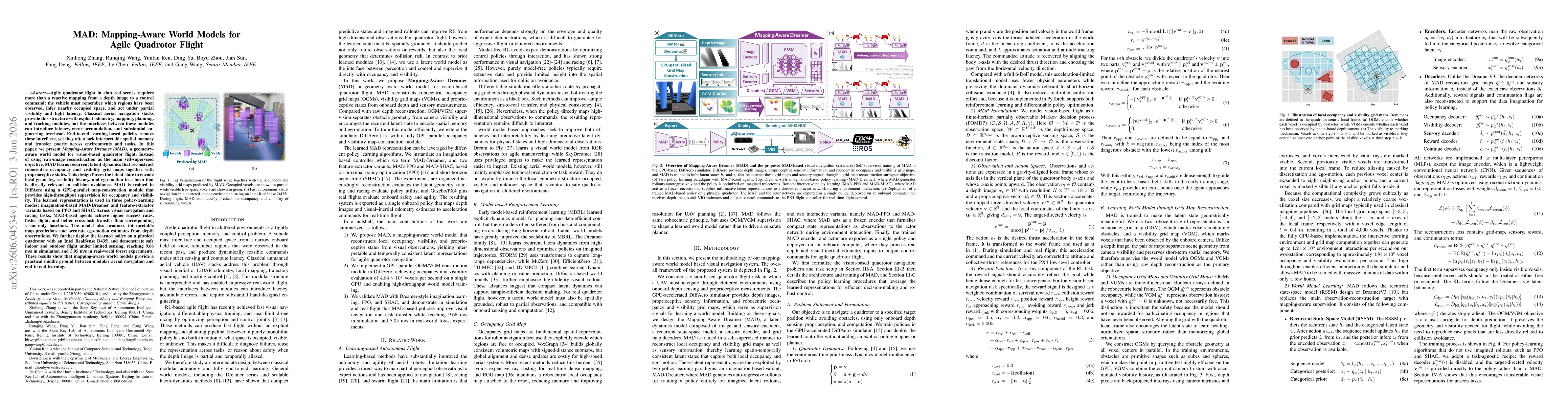
Agile quadrotor flight in cluttered scenes requires more than a reactive mapping from a depth image to a control command: the vehicle must remember which regions have been observed, infer nearby occup...

Diffusion-based visuomotor policies deployed with asynchronous inference often exhibit inter-chunk discontinuities and lack explicit mechanisms for obstacle-aware execution, leading to jerky motions a...
Multi-camera visual-inertial odometry (VIO) overcomes the inherent limitations of pure visual systems by expanding the field of view. However, existing algorithms are typically tailored for fixed came...