EPIC: A Lightweight LiDAR-Based UAV Exploration Framework for Large-Scale Scenarios
Publication
Metrics
AI Quick Summary
EPIC is a lightweight LiDAR-based UAV exploration framework that utilizes point cloud data directly for navigation and path planning, eliminating the need for memory-intensive occupancy grid maps. EPIC's novel observation map and incremental topological graph construction enable real-time, agile, and energy-efficient exploration of large-scale environments, significantly reducing memory and computation time compared to existing methods.
Paper Preview
Abstract
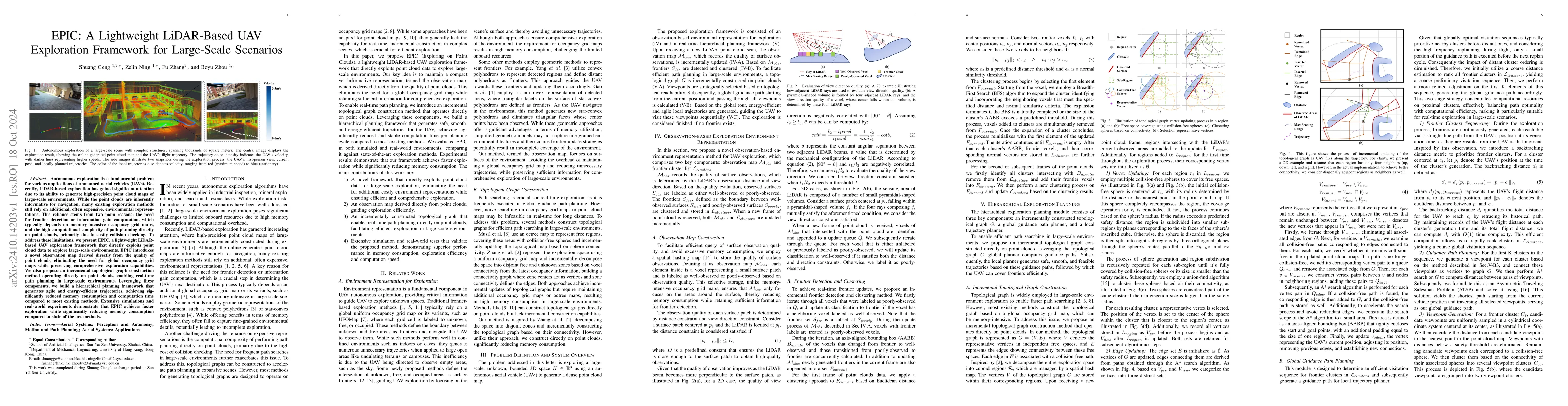
Autonomous exploration is a fundamental problem for various applications of unmanned aerial vehicles (UAVs). Recently, LiDAR-based exploration has gained significant attention due to its ability to generate high-precision point cloud maps of large-scale environments. While the point clouds are inherently informative for navigation, many existing exploration methods still rely on additional, often expensive, environmental representations. This reliance stems from two main reasons: the need for frontier detection or information gain computation, which typically depends on memory-intensive occupancy grid maps, and the high computational complexity of path planning directly on point clouds, primarily due to costly collision checking. To address these limitations, we present EPIC, a lightweight LiDAR-based UAV exploration framework that directly exploits point cloud data to explore large-scale environments. EPIC introduces a novel observation map derived directly from the quality of point clouds, eliminating the need for global occupancy grid maps while preserving comprehensive exploration capabilities. We also propose an incremental topological graph construction method operating directly on point clouds, enabling real-time path planning in large-scale environments. Leveraging these components, we build a hierarchical planning framework that generates agile and energy-efficient trajectories, achieving significantly reduced memory consumption and computation time compared to most existing methods. Extensive simulations and real-world experiments demonstrate that EPIC achieves faster exploration while significantly reducing memory consumption compared to state-of-the-art methods.
AI Key Findings
Get AI-generated insights about this paper's methodology, results, significance, and more — seven facets brought into focus.
Impact
Authors
PDF Preview
Citation Network
Current paper (gray), citations (green), references (blue)
Display is limited for performance on very large graphs.
Discussion 0