Academic Profile
Statistics
Similar Authors
Papers on arXiv
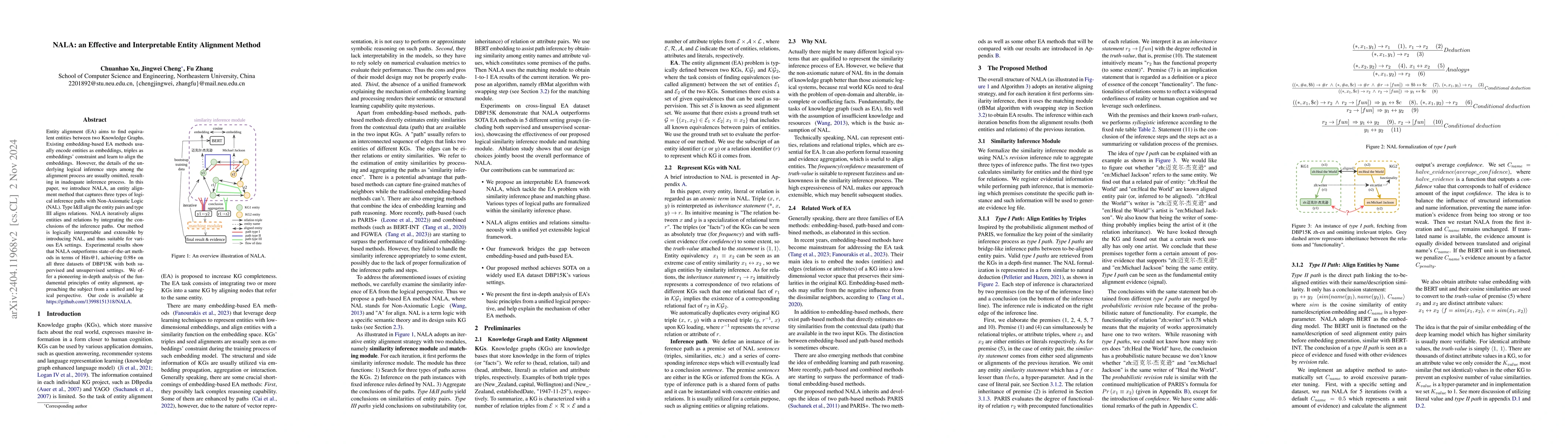
Entity alignment (EA) aims to find equivalent entities between two Knowledge Graphs. Existing embedding-based EA methods usually encode entities as embeddings, triples as embeddings' constraint and ...
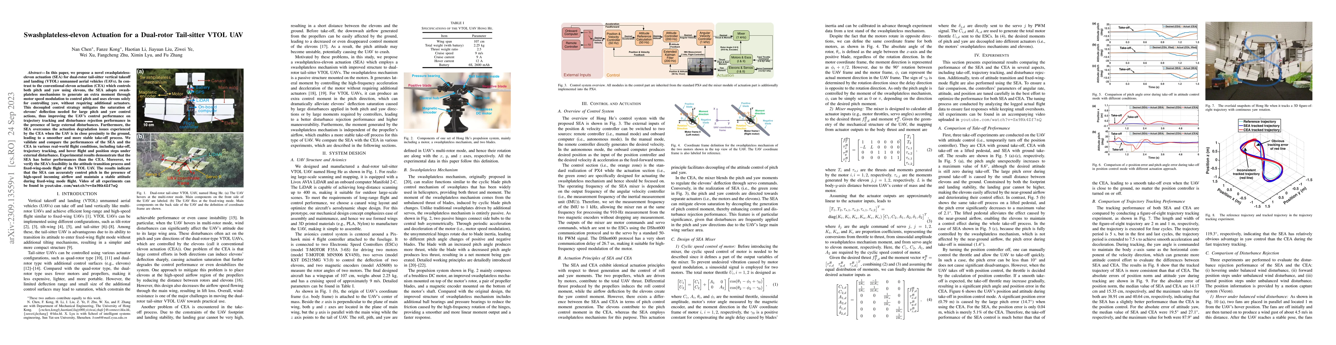
In this paper, we propose a novel swashplateless-elevon actuation (SEA) for dual-rotor tail-sitter vertical takeoff and landing (VTOL) unmanned aerial vehicles (UAVs). In contrast to the conventiona...
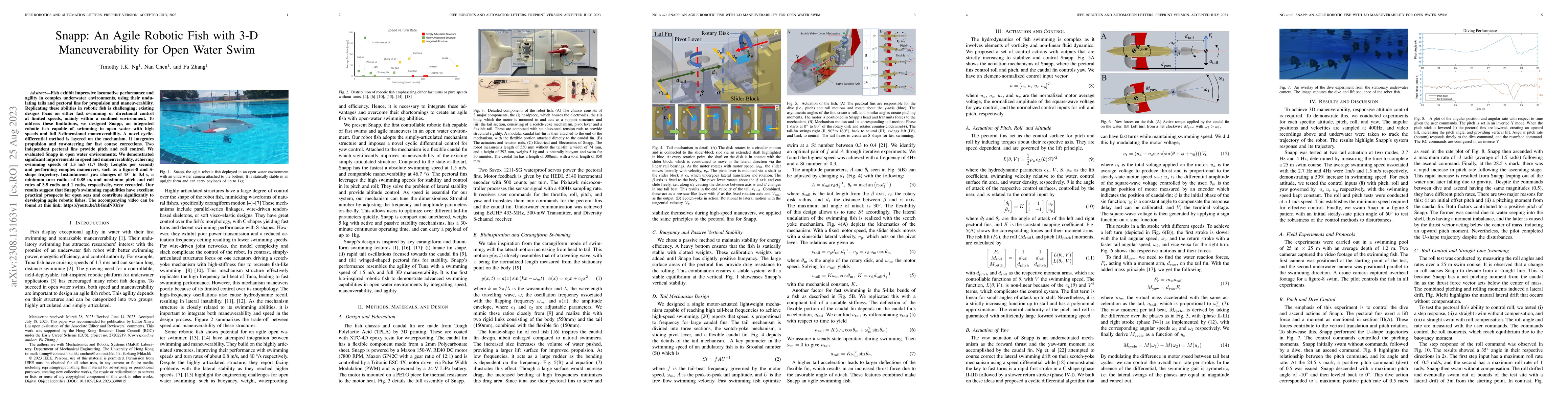
Fish exhibit impressive locomotive performance and agility in complex underwater environments, using their undulating tails and pectoral fins for propulsion and maneuverability. Replicating these ab...
This paper introduces a novel targetless method for joint intrinsic and extrinsic calibration of LiDAR-camera systems using plane-constrained bundle adjustment (BA). Our method leverages LiDAR point...
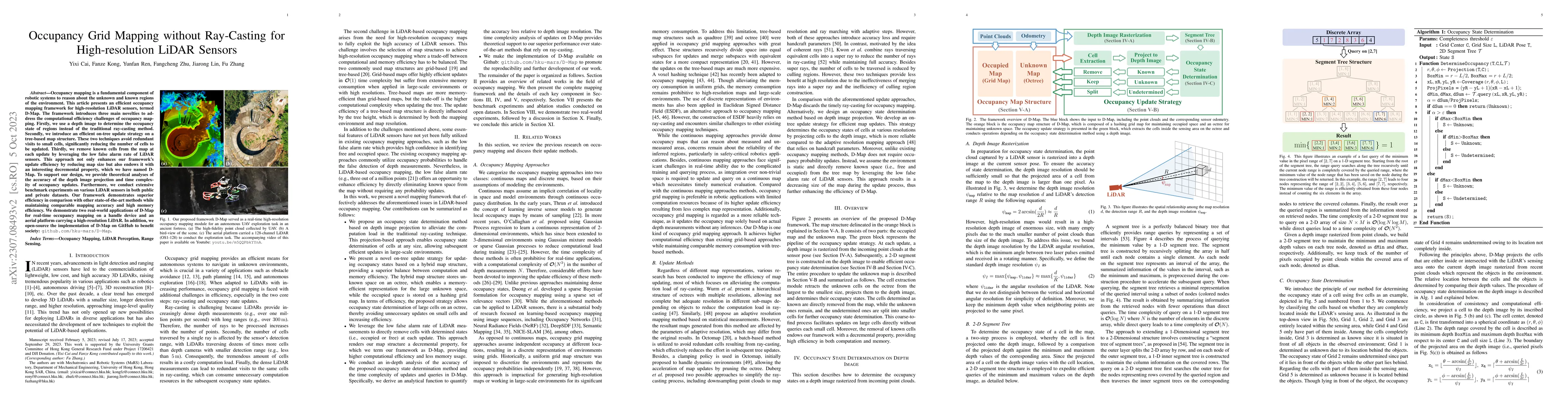
Occupancy mapping is a fundamental component of robotic systems to reason about the unknown and known regions of the environment. This article presents an efficient occupancy mapping framework for h...
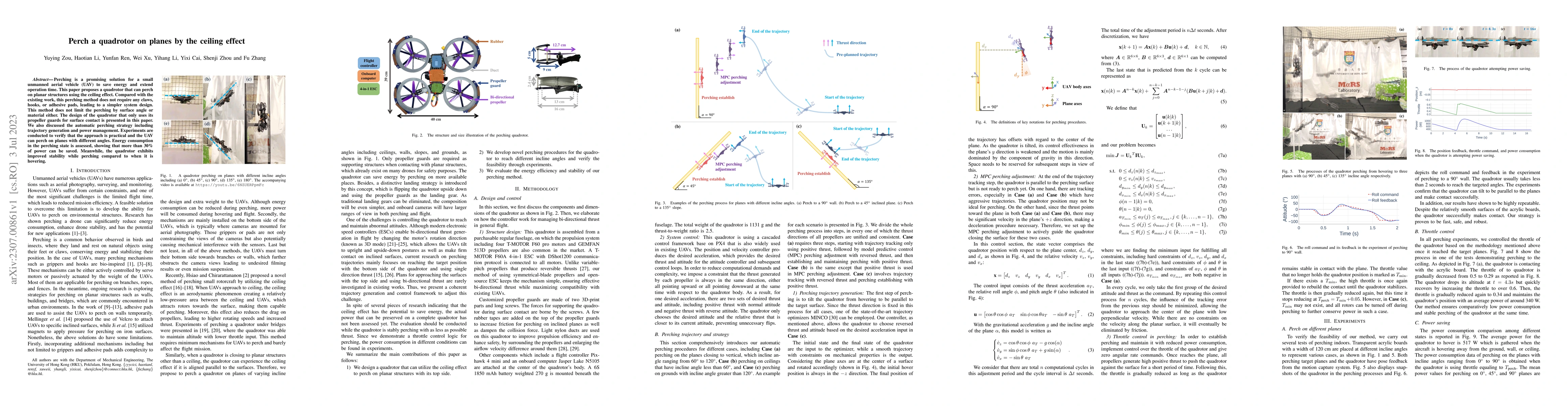
Perching is a promising solution for a small unmanned aerial vehicle (UAV) to save energy and extend operation time. This paper proposes a quadrotor that can perch on planar structures using the cei...
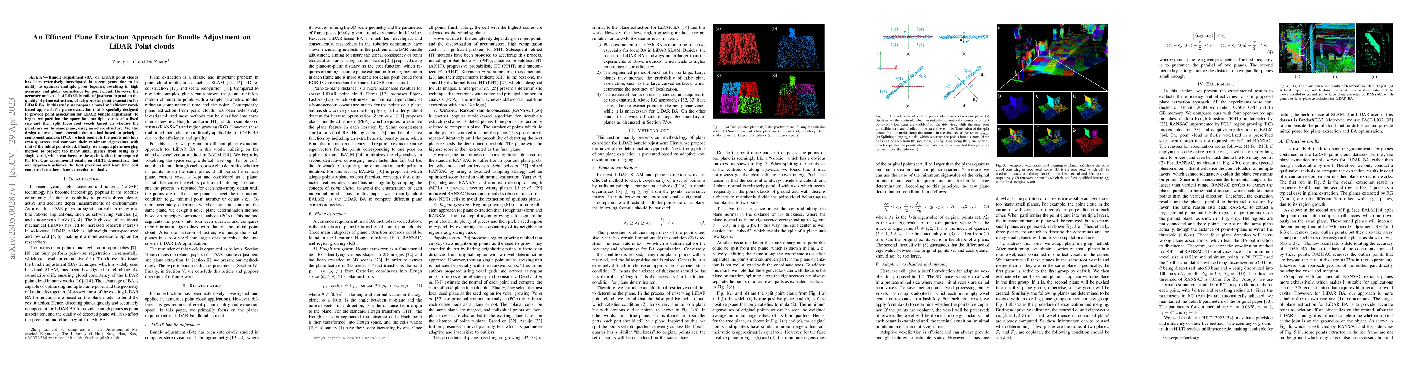
Bundle adjustment (BA) on LiDAR point clouds has been extensively investigated in recent years due to its ability to optimize multiple poses together, resulting in high accuracy and global consisten...
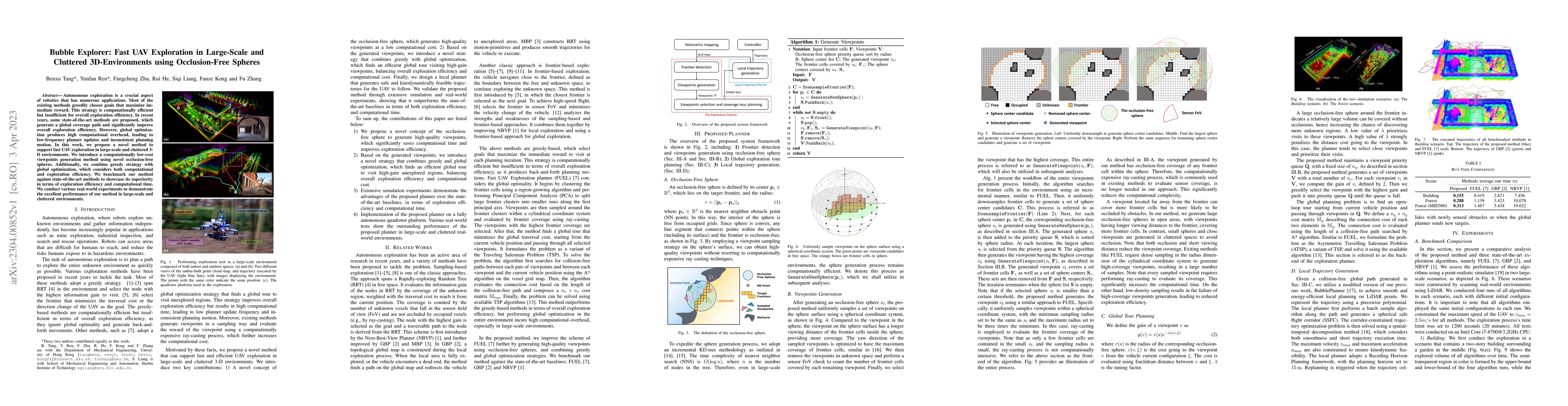
Autonomous exploration is a crucial aspect of robotics that has numerous applications. Most of the existing methods greedily choose goals that maximize immediate reward. This strategy is computation...
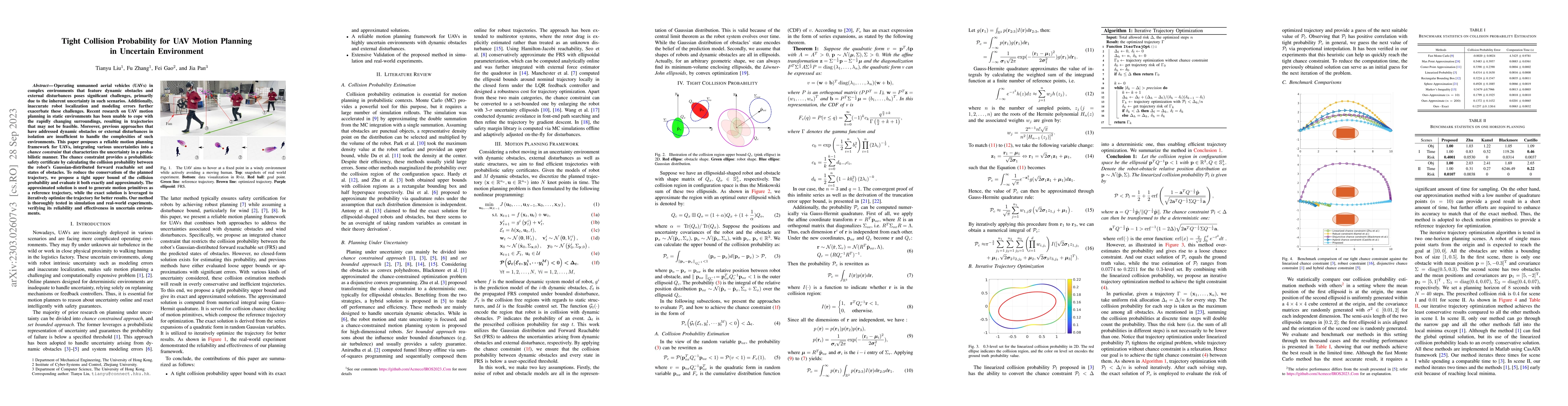
Operating unmanned aerial vehicles (UAVs) in complex environments that feature dynamic obstacles and external disturbances poses significant challenges, primarily due to the inherent uncertainty in ...
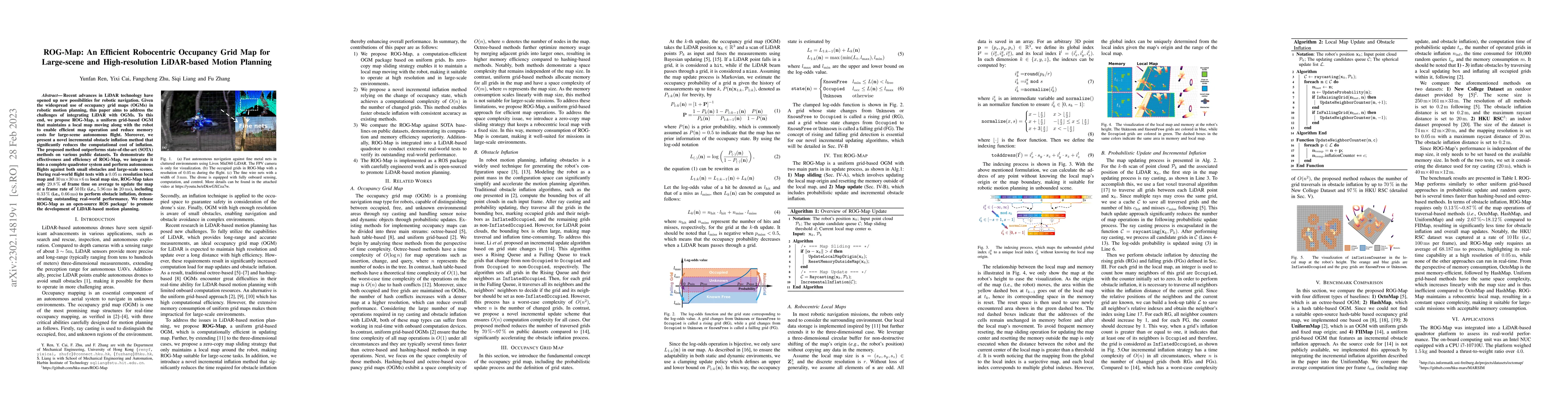
Recent advances in LiDAR technology have opened up new possibilities for robotic navigation. Given the widespread use of occupancy grid maps (OGMs) in robotic motion planning, this paper aims to add...
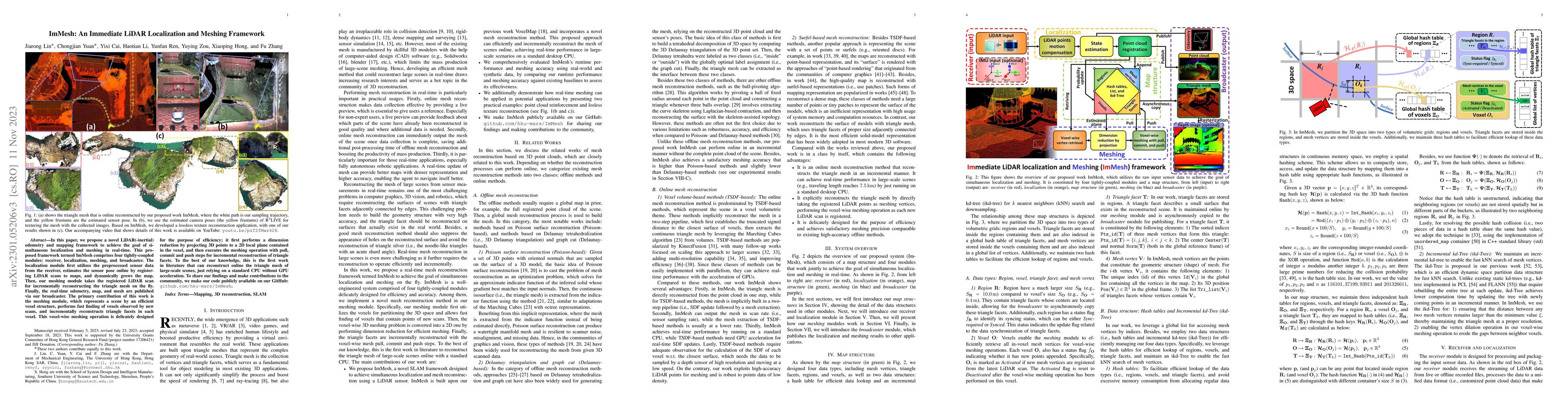
In this paper, we propose a novel LiDAR(-inertial) odometry and mapping framework to achieve the goal of simultaneous localization and meshing in real-time. This proposed framework termed ImMesh com...
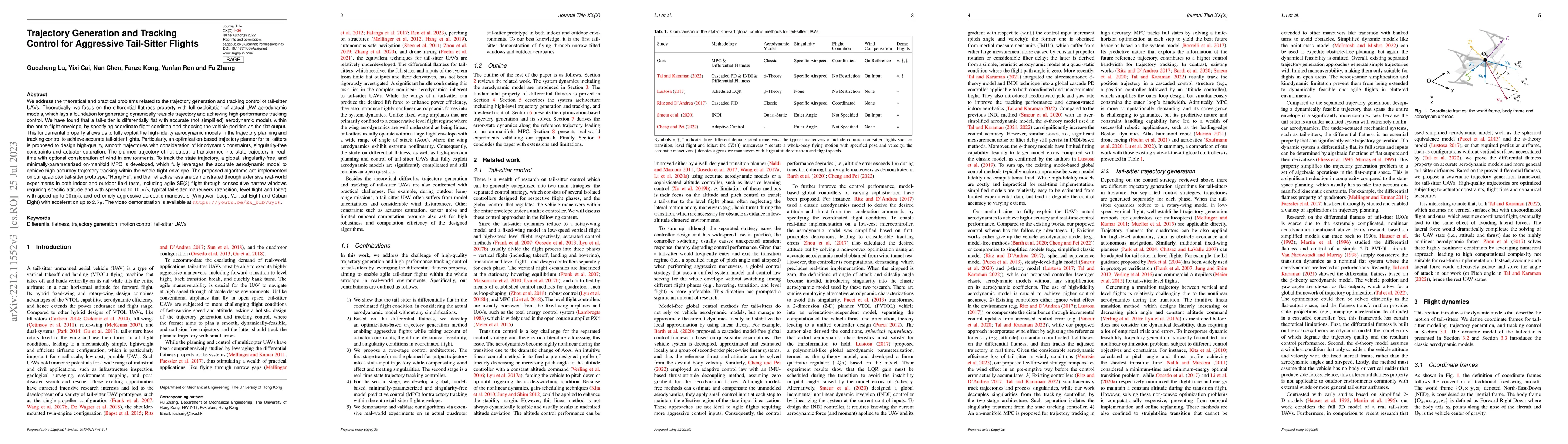
We address the theoretical and practical problems related to the trajectory generation and tracking control of tail-sitter UAVs. Theoretically, we focus on the differential flatness property with fu...
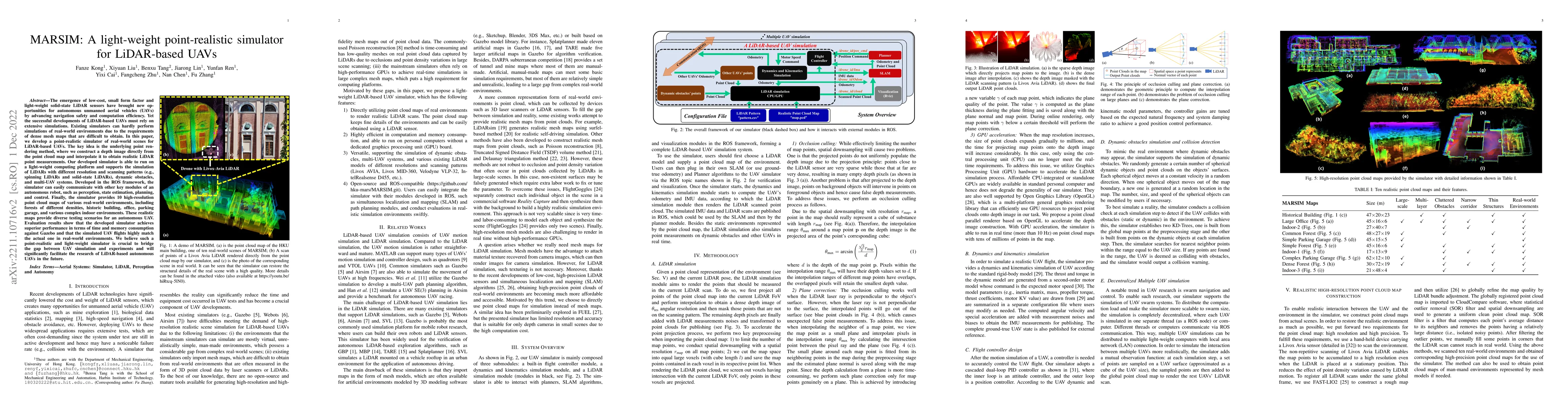
The emergence of low-cost, small form factor and light-weight solid-state LiDAR sensors have brought new opportunities for autonomous unmanned aerial vehicles (UAVs) by advancing navigation safety a...
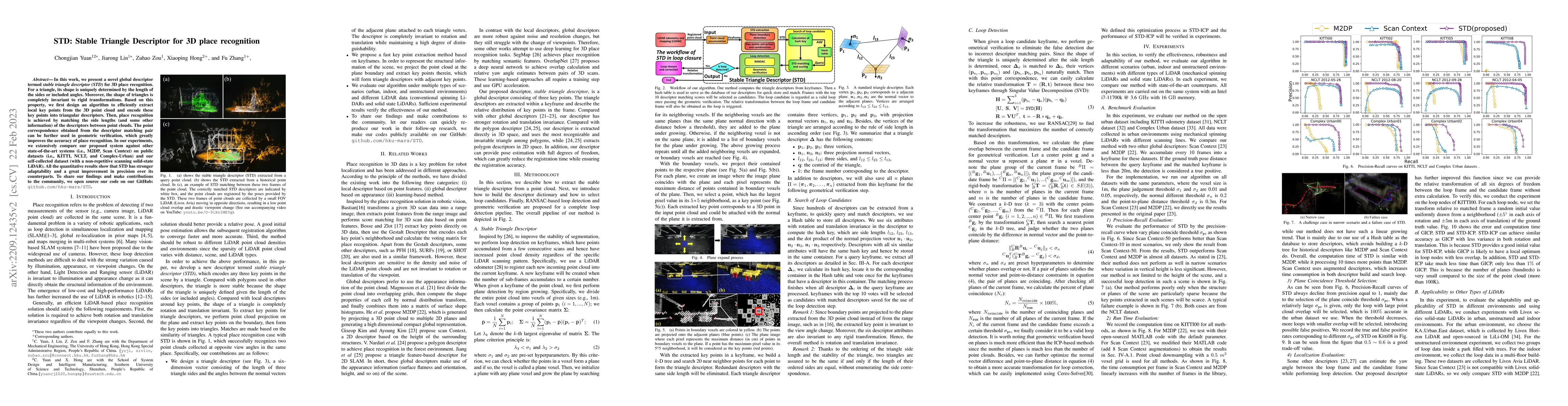
In this work, we present a novel global descriptor termed stable triangle descriptor (STD) for 3D place recognition. For a triangle, its shape is uniquely determined by the length of the sides or in...
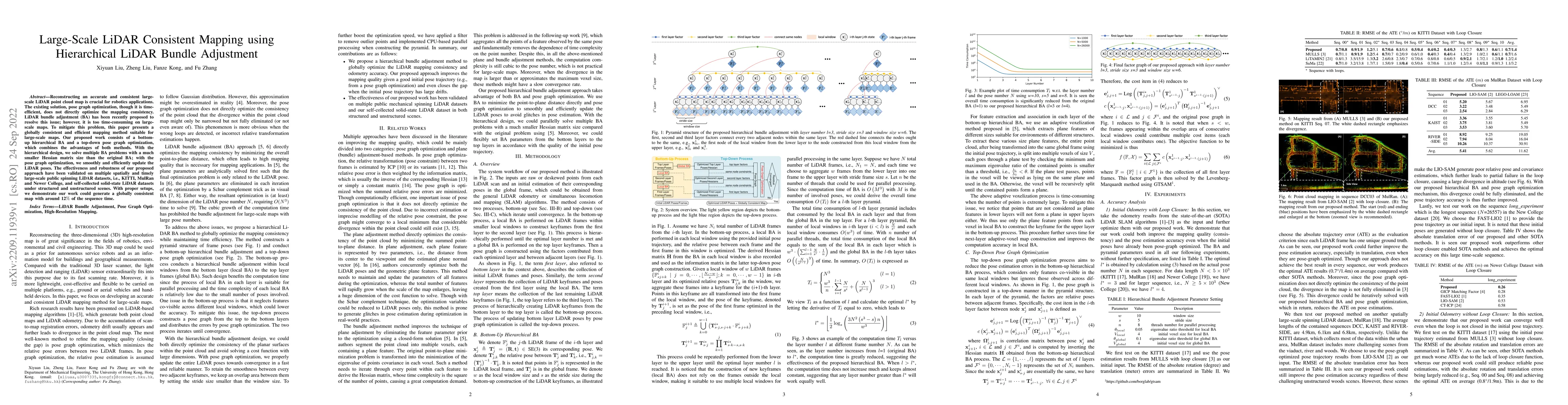
Reconstructing an accurate and consistent large-scale LiDAR point cloud map is crucial for robotics applications. The existing solution, pose graph optimization, though it is time-efficient, does no...
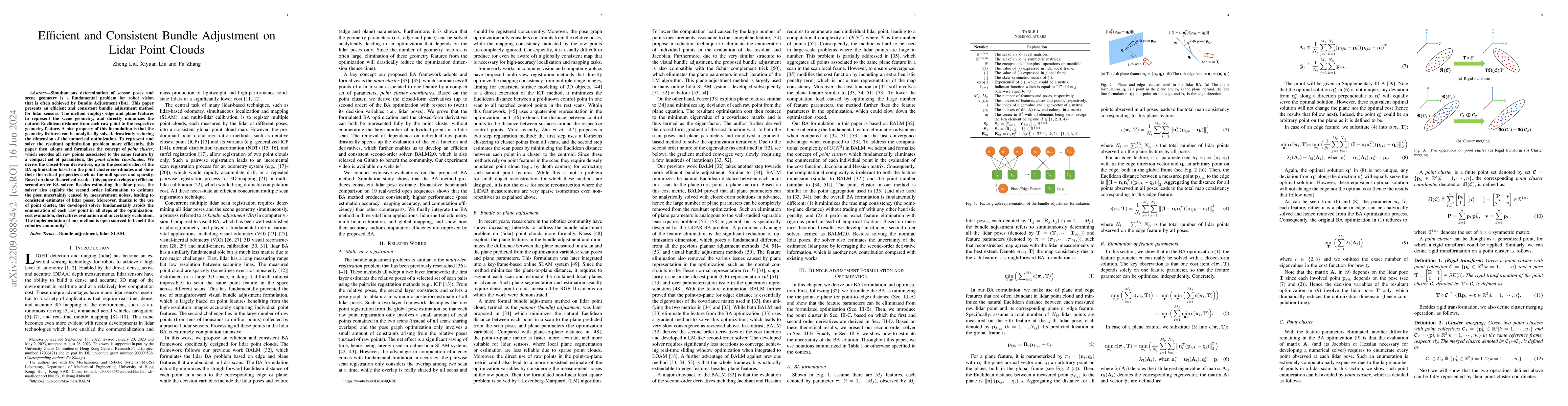
Bundle Adjustment (BA) refers to the problem of simultaneous determination of sensor poses and scene geometry, which is a fundamental problem in robot vision. This paper presents an efficient and co...
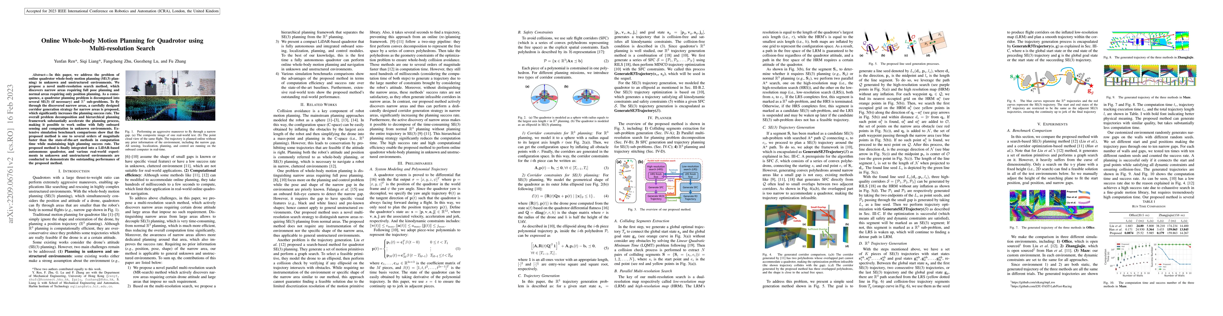
In this paper, we address the problem of online quadrotor whole-body motion planning (SE(3) planning) in unknown and unstructured environments. We propose a novel multi-resolution search method, whi...
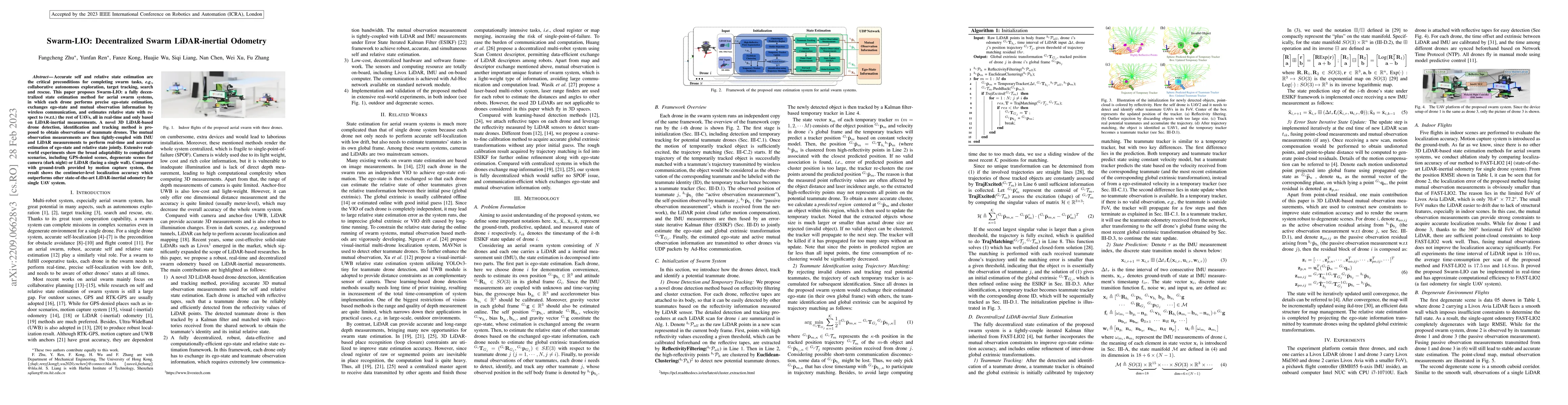
Accurate self and relative state estimation are the critical preconditions for completing swarm tasks, e.g., collaborative autonomous exploration, target tracking, search and rescue. This paper prop...
Simultaneous localization and mapping (SLAM) are crucial for autonomous robots (e.g., self-driving cars, autonomous drones), 3D mapping systems, and AR/VR applications. This work proposed a novel Li...
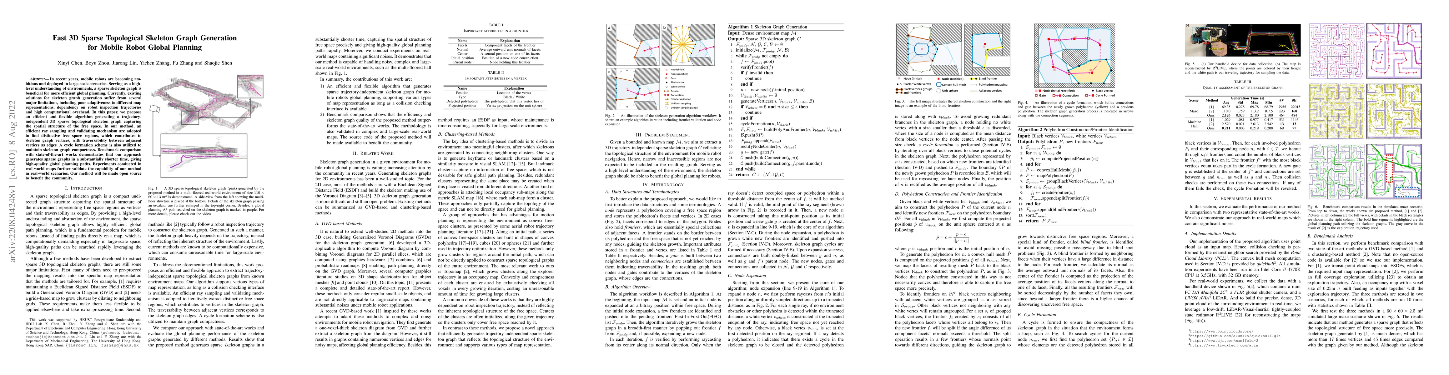
In recent years, mobile robots are becoming ambitious and deployed in large-scale scenarios. Serving as a high-level understanding of environments, a sparse skeleton graph is beneficial for more eff...
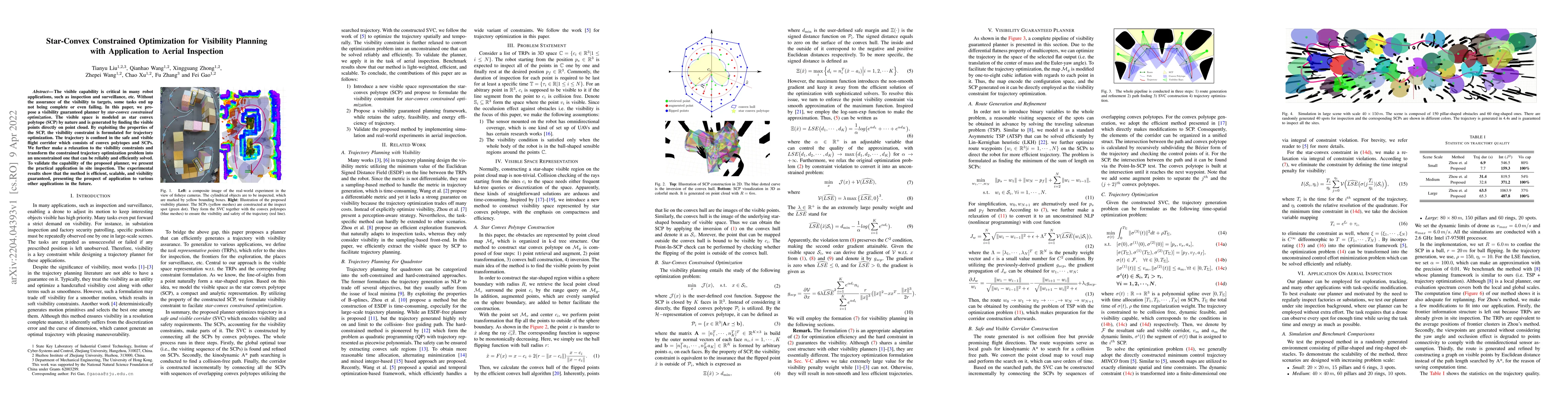
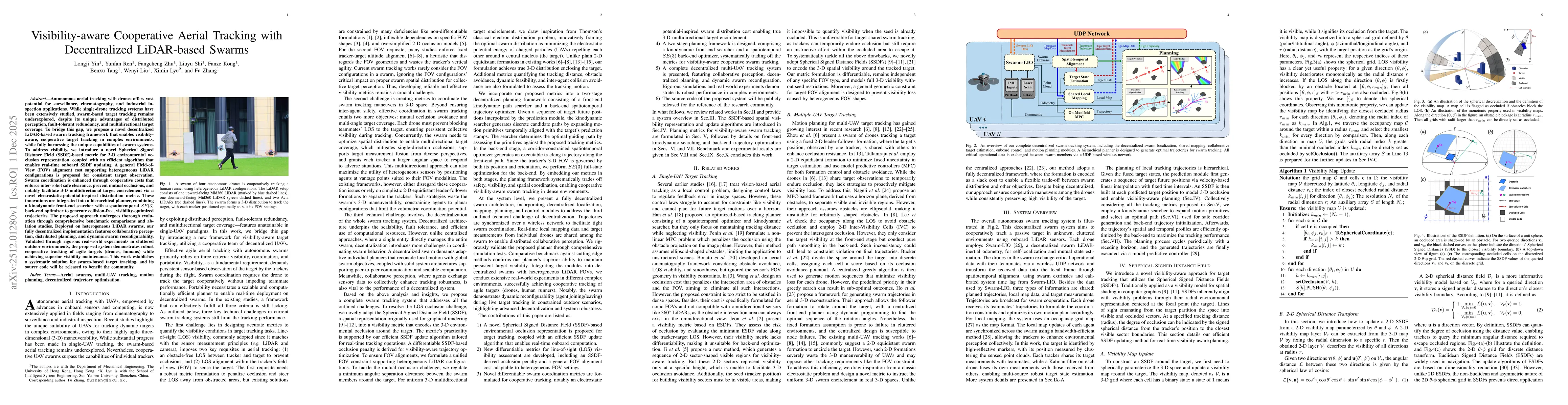
The visible capability is critical in many robot applications, such as inspection and surveillance, etc. Without the assurance of the visibility to targets, some tasks end up not being complete or e...
To achieve accurate and robust pose estimation in Simultaneous Localization and Mapping (SLAM) task, multi-sensor fusion is proven to be an effective solution and thus provides great potential in ro...
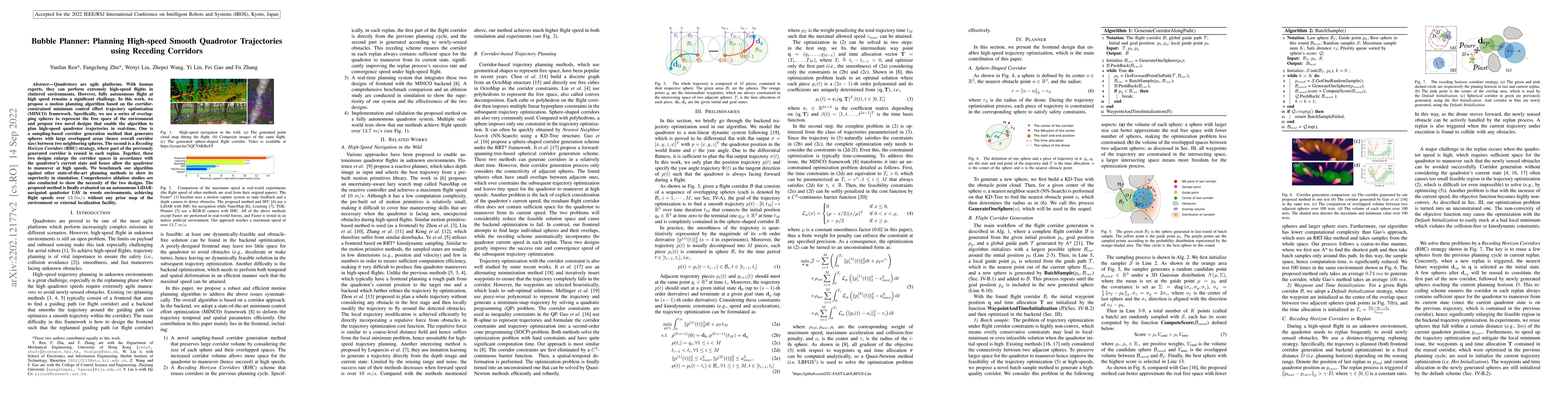
Quadrotors are agile platforms. With human experts, they can perform extremely high-speed flights in cluttered environments. However, fully autonomous flight at high speed remains a significant chal...
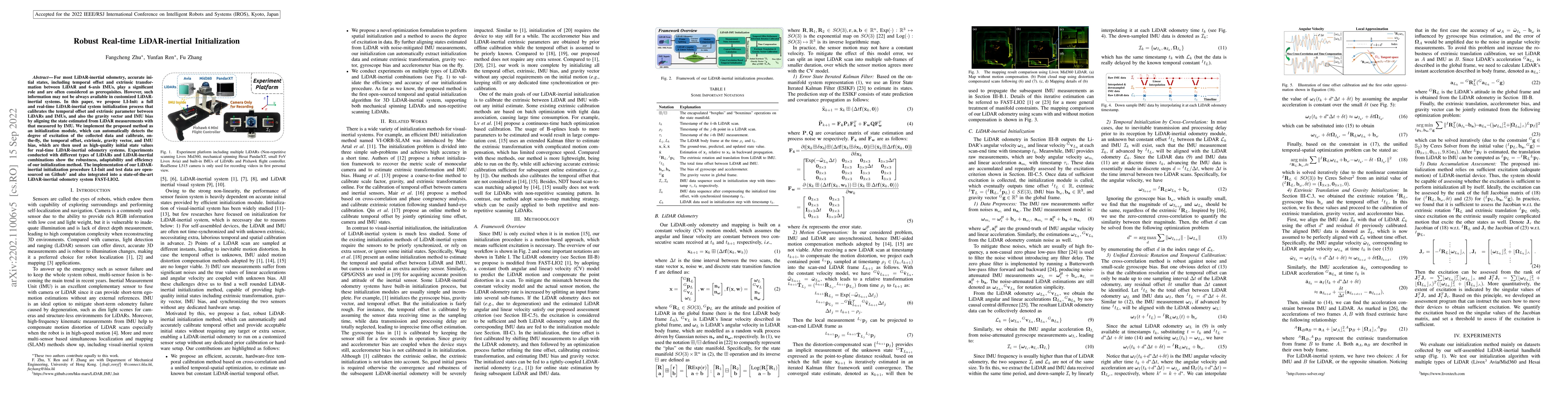
For most LiDAR-inertial odometry, accurate initial states, including temporal offset and extrinsic transformation between LiDAR and 6-axis IMUs, play a significant role and are often considered as p...
Two-dimensional materials (2DM) have attracted much interest due to their distinct optical, electronic, and catalytic properties. These properties can be by tuned a range of methods including substi...
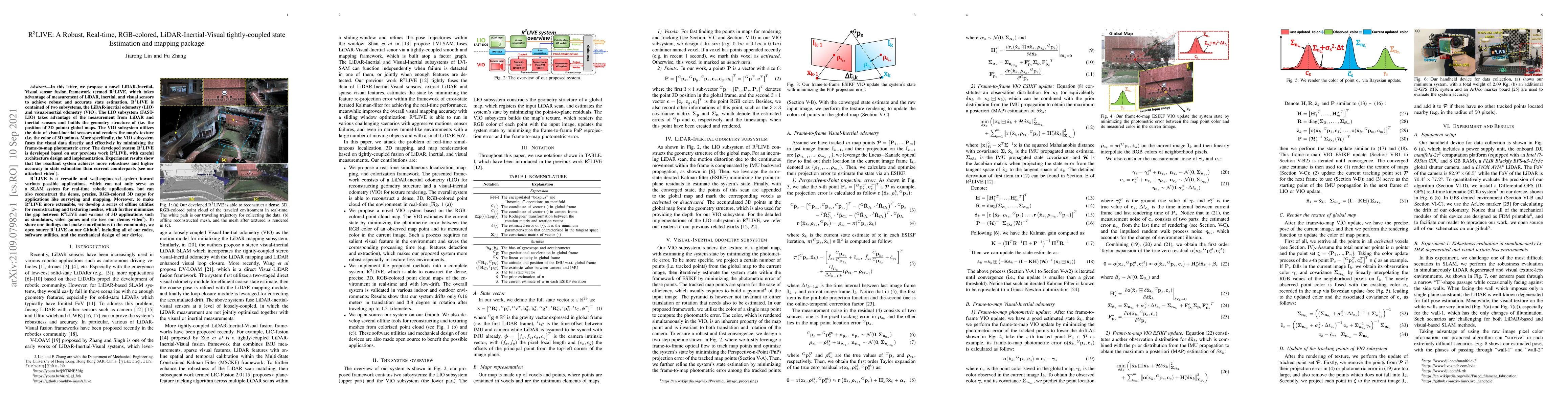
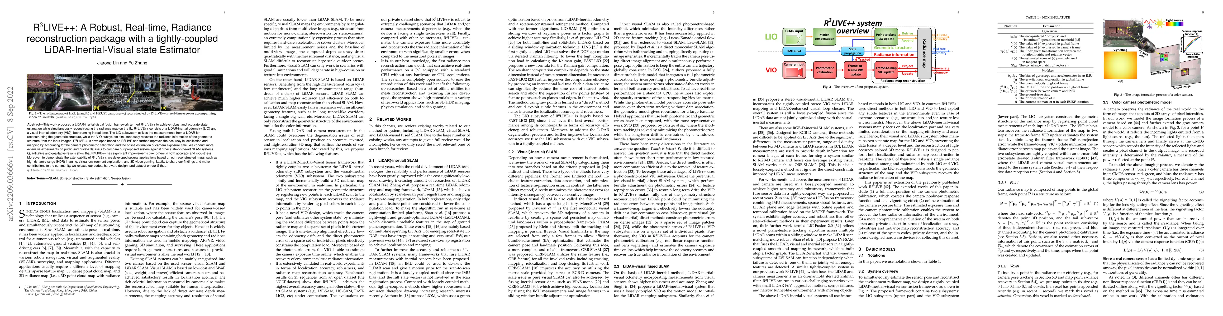
In this letter, we propose a novel LiDAR-Inertial-Visual sensor fusion framework termed R3LIVE, which takes advantage of measurement of LiDAR, inertial, and visual sensors to achieve robust and accu...
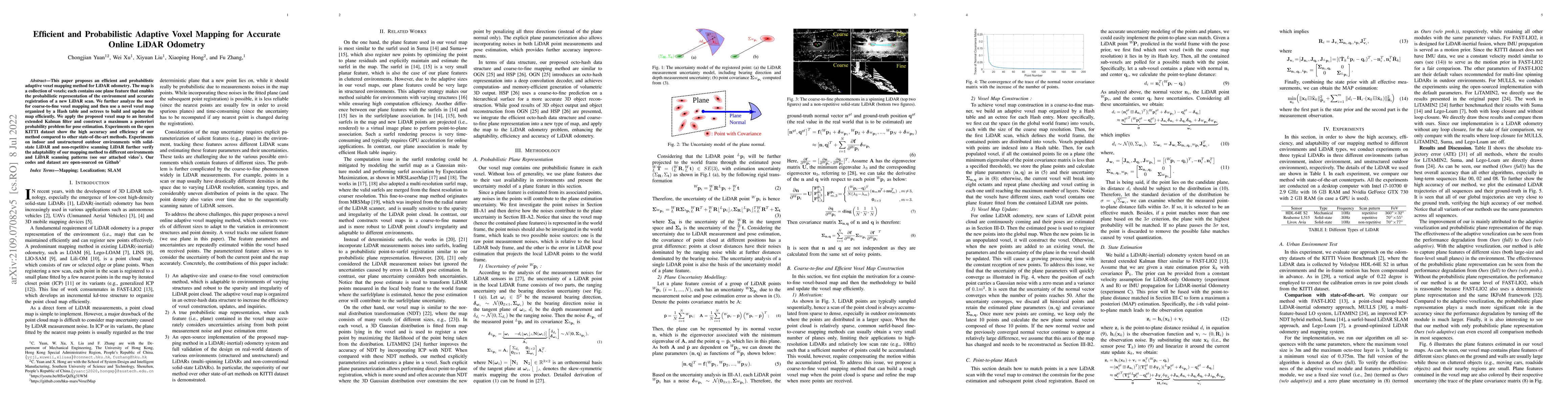
This paper proposes an efficient and probabilistic adaptive voxel mapping method for LiDAR odometry. The map is a collection of voxels; each contains one plane (or edge) feature that enables the pro...
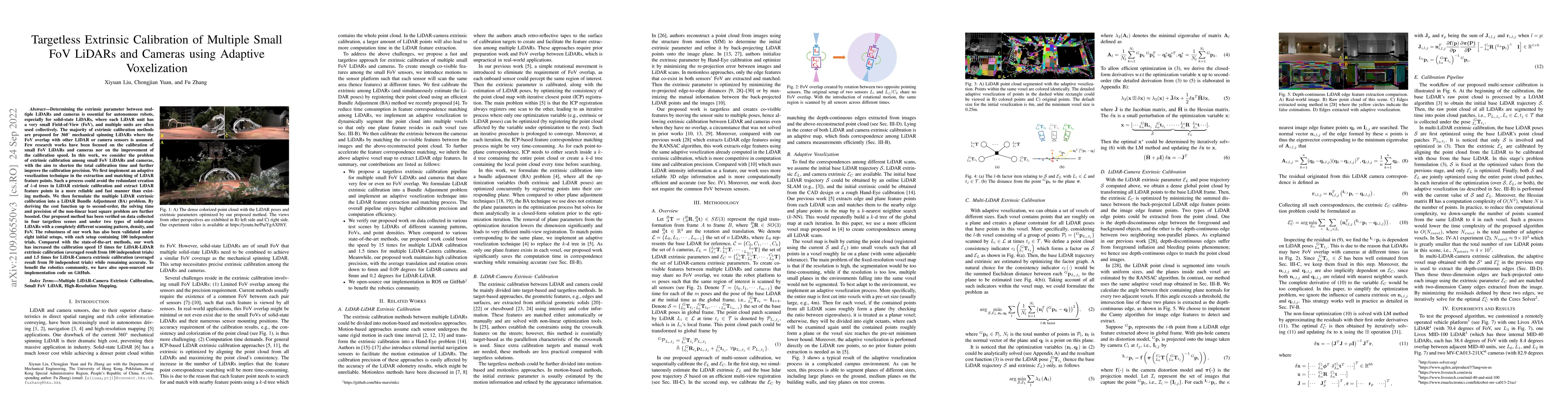
Determining the extrinsic parameter between multiple LiDARs and cameras is essential for autonomous robots, especially for solid-state LiDARs, where each LiDAR unit has a very small Field-of-View (F...
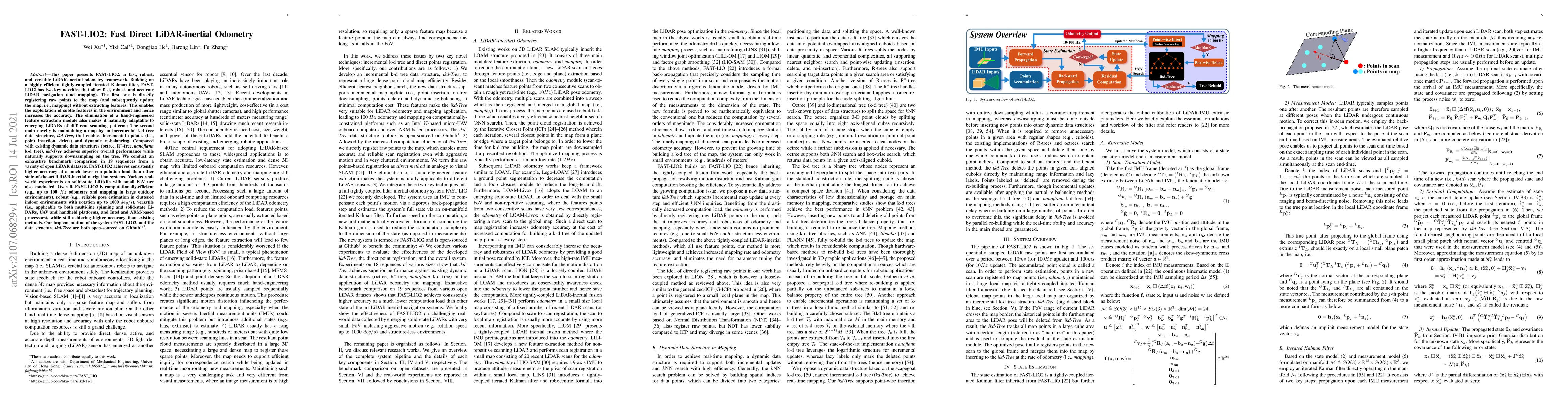
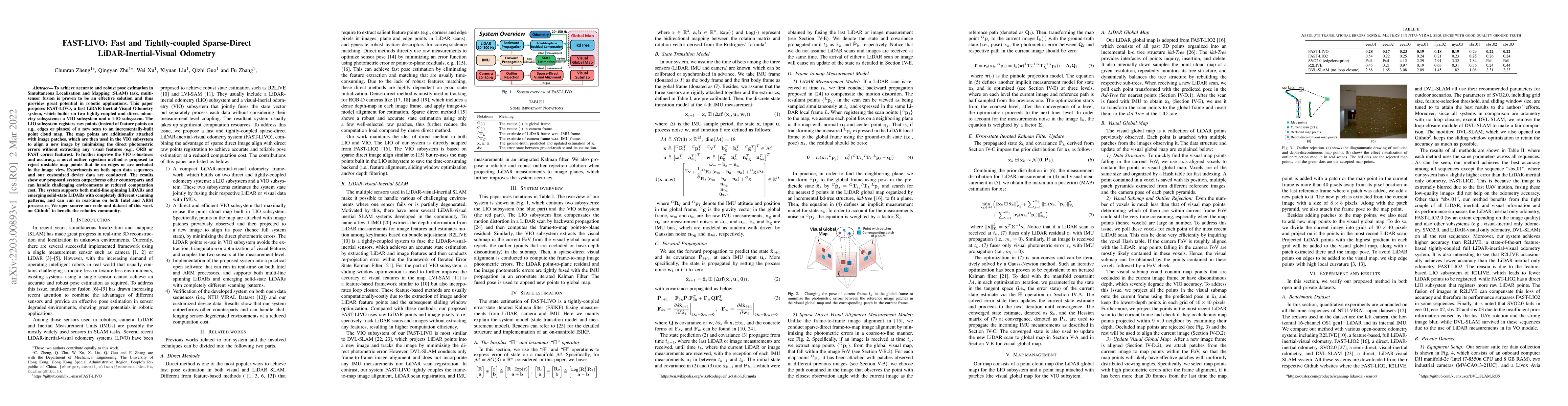
This paper presents FAST-LIO2: a fast, robust, and versatile LiDAR-inertial odometry framework. Building on a highly efficient tightly-coupled iterated Kalman filter, FAST-LIO2 has two key novelties...
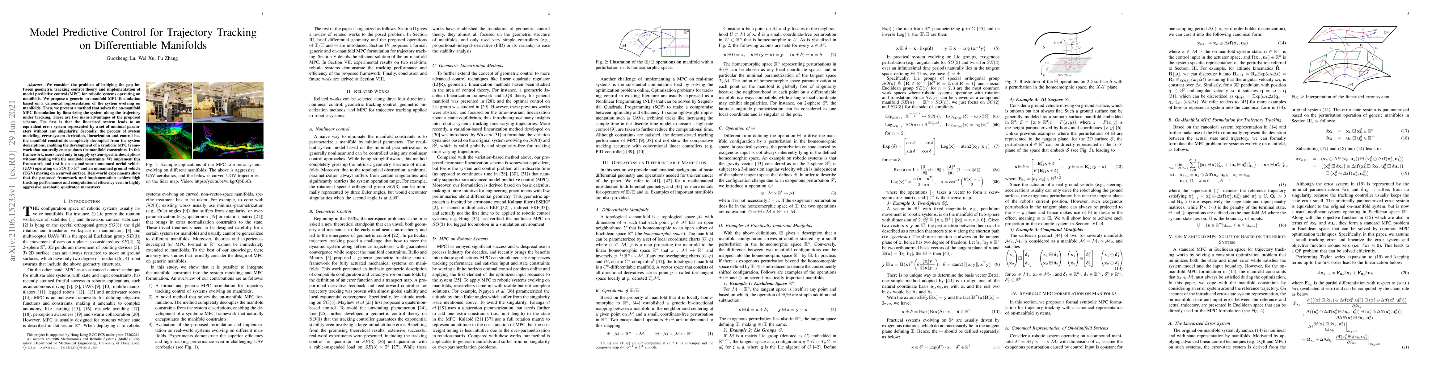
We consider the problem of bridging the gap between geometric tracking control theory and implementation of model predictive control (MPC) for robotic systems operating on manifolds. We propose a ge...
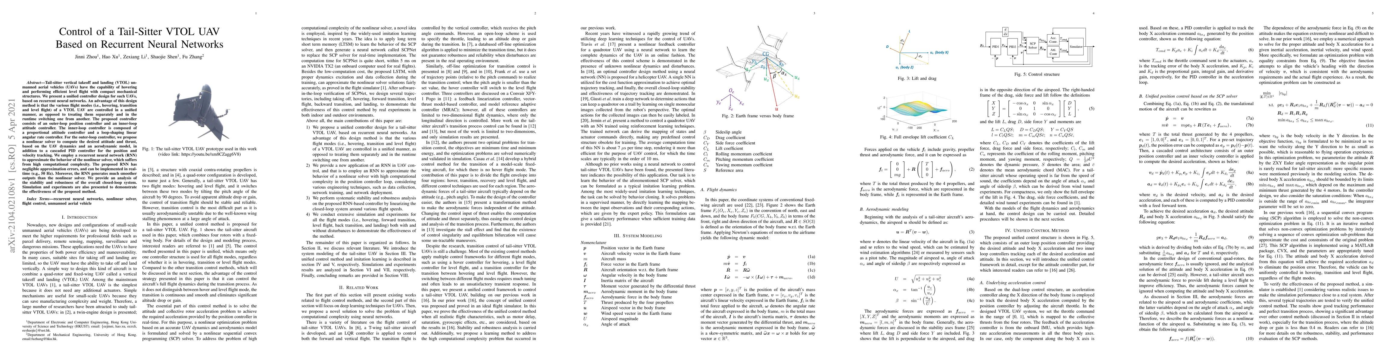
Tail-sitter vertical takeoff and landing (VTOL) unmanned aerial vehicles (UAVs) have the capability of hovering and performing efficient level flight with compact mechanical structures. We present a...
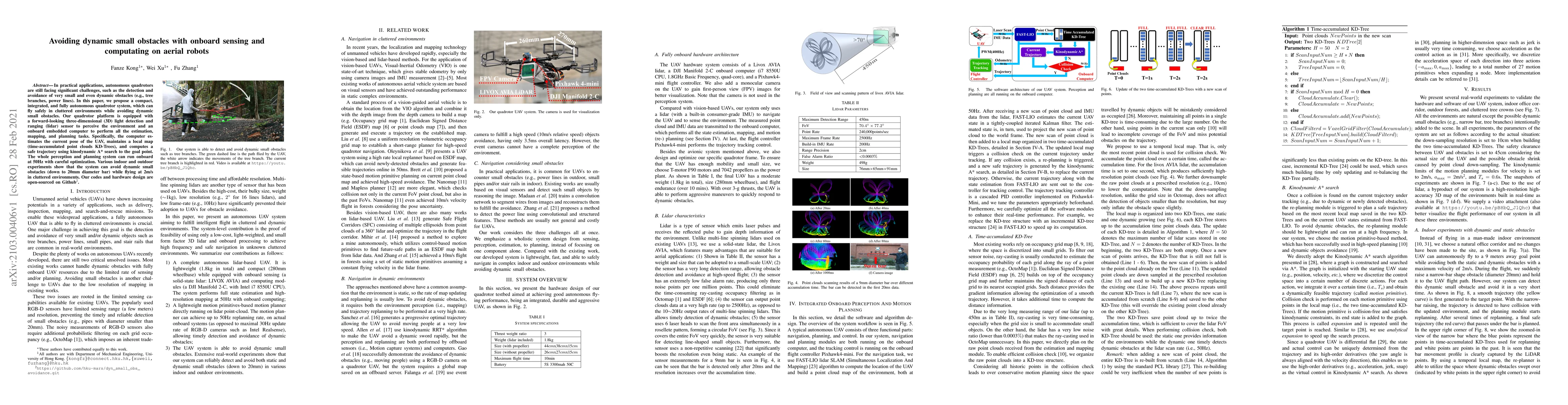
In practical applications, autonomous quadrotors are still facing significant challenges, such as the detection and avoidance of very small and even dynamic obstacles (e.g., tree branches, power lin...
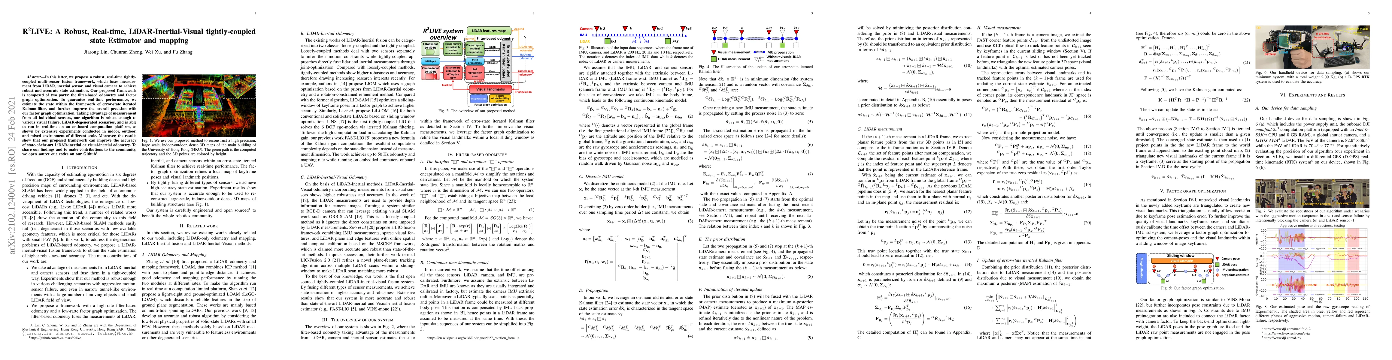
In this letter, we propose a robust, real-time tightly-coupled multi-sensor fusion framework, which fuses measurement from LiDAR, inertial sensor, and visual camera to achieve robust and accurate st...
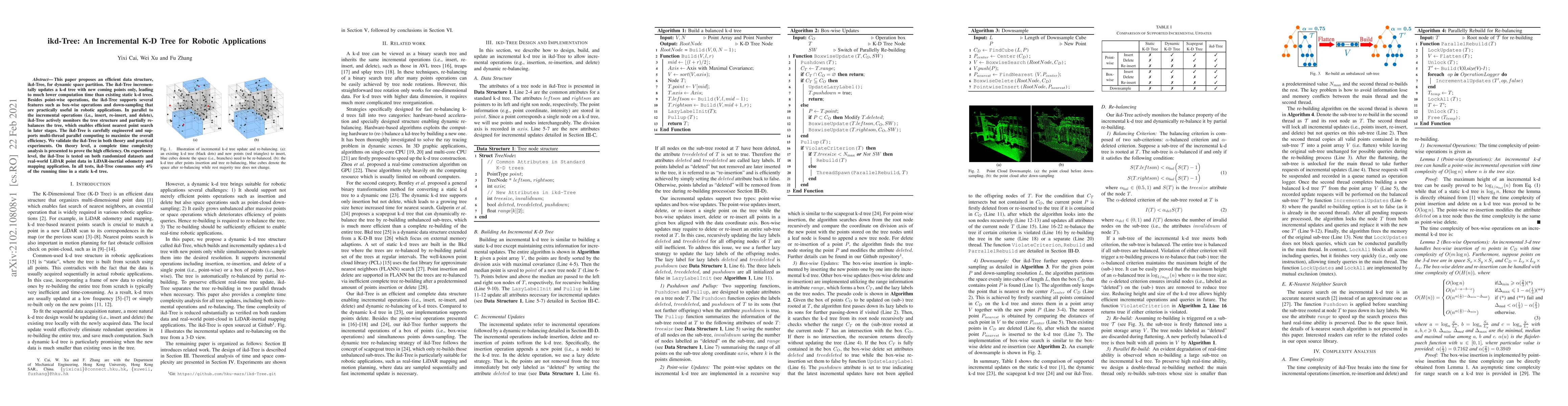
This paper proposes an efficient data structure, ikd-Tree, for dynamic space partition. The ikd-Tree incrementally updates a k-d tree with new coming points only, leading to much lower computation t...
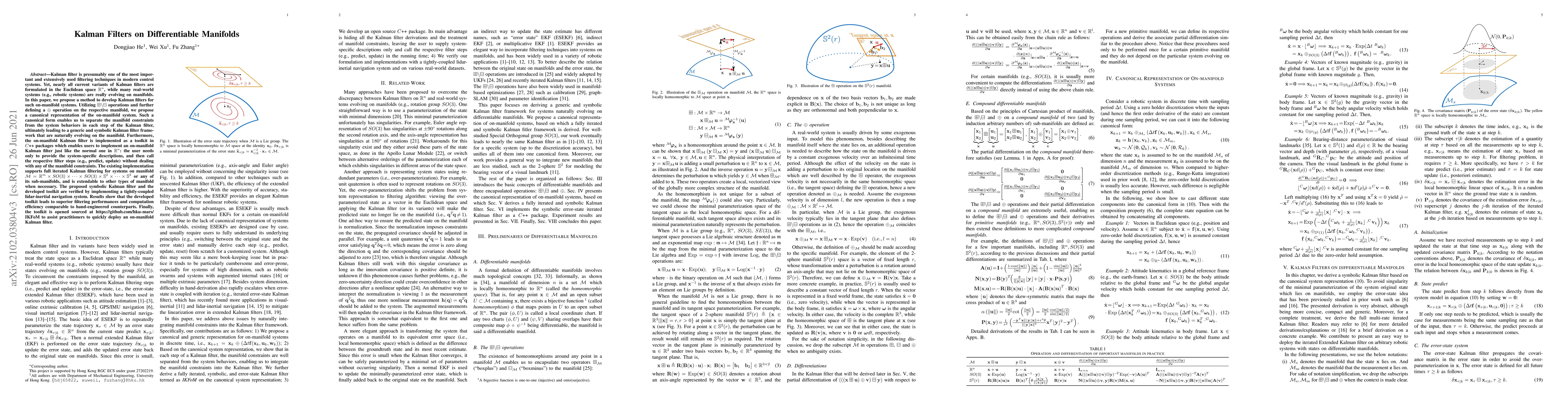
Kalman filter is presumably one of the most important and extensively used filtering techniques in modern control systems. Yet, nearly all current variants of Kalman filters are formulated in the Eu...
This paper studies an infinite horizon optimal control problem for discrete-time linear systems and quadratic criteria, both with random parameters which are independent and identically distributed ...
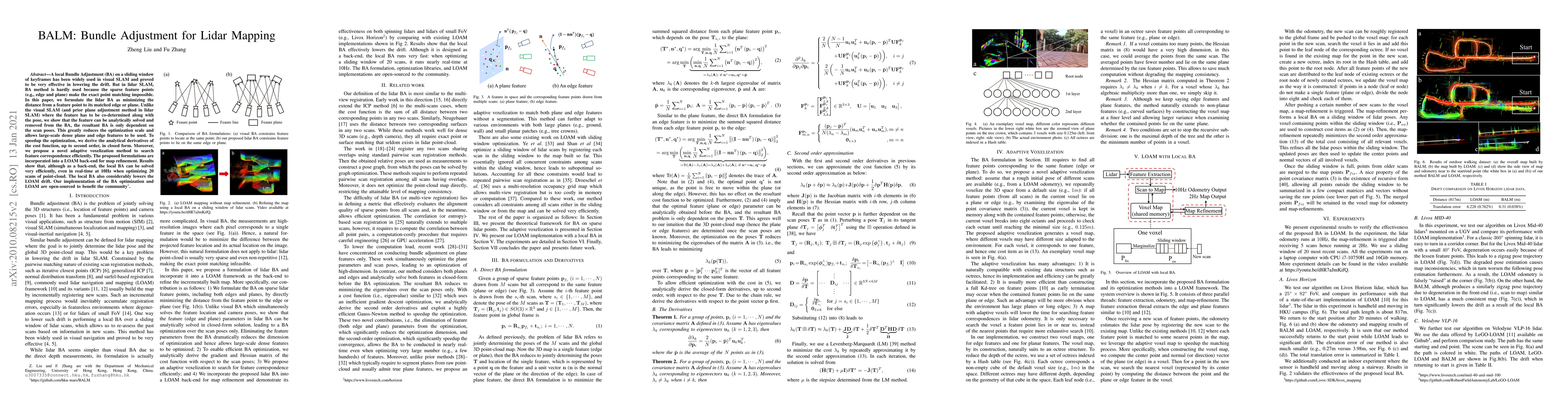
A local Bundle Adjustment (BA) on a sliding window of keyframes has been widely used in visual SLAM and proved to be very effective in lowering the drift. But in lidar SLAM, BA method is hardly used...
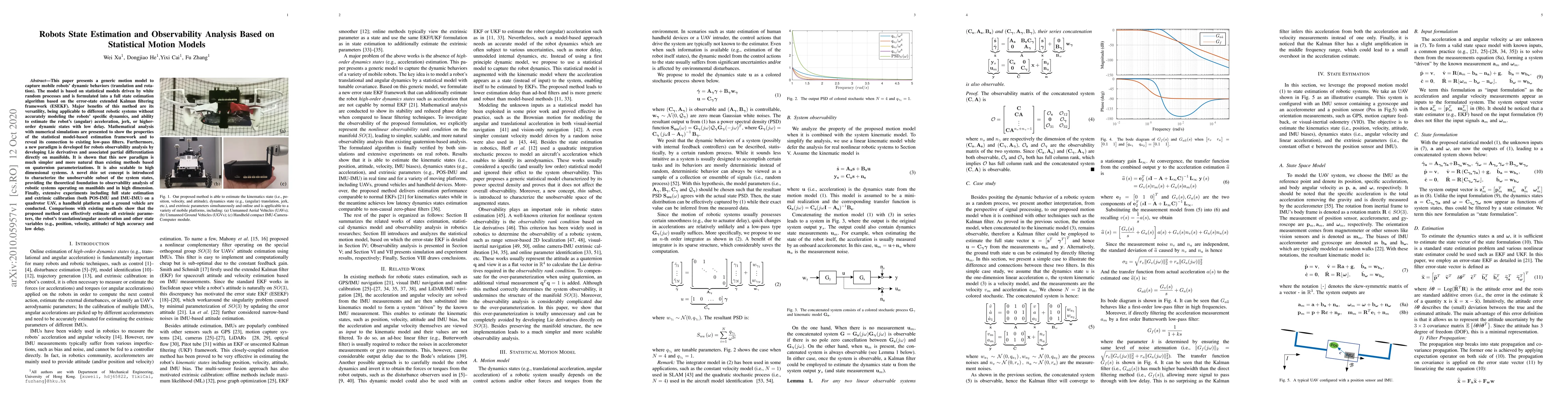
This paper presents a generic motion model to capture mobile robots' dynamic behaviors (translation and rotation). The model is based on statistical models driven by white random processes and is fo...
Atomically thin transition metal dichalcogenide (TMD) semiconductors hold enormous potential for modern optoelectronic devices and quantum computing applications. By inducing long-range ferromagneti...
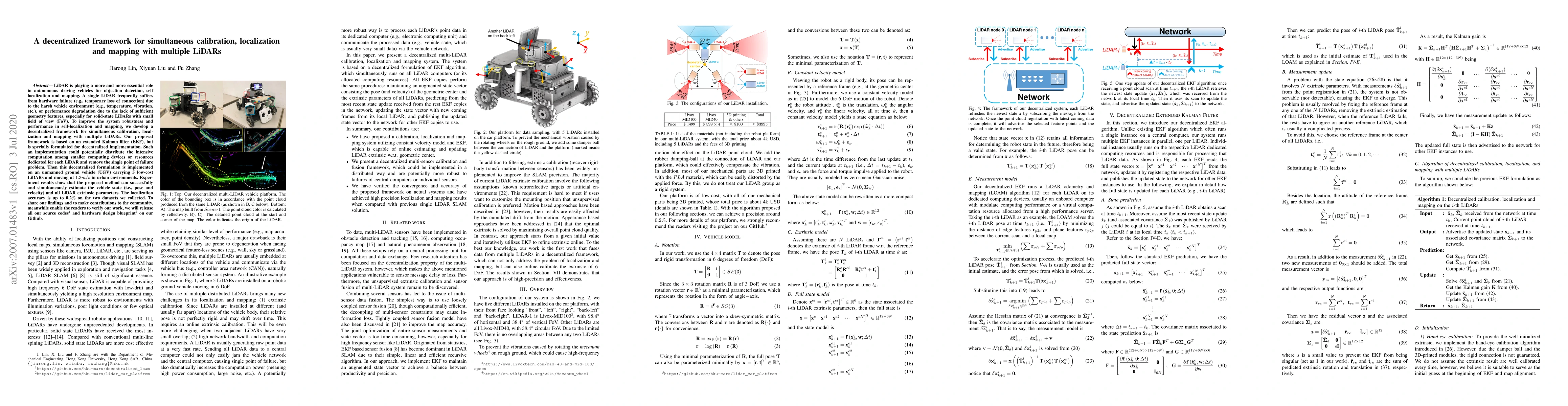
LiDAR is playing a more and more essential role in autonomous driving vehicles for objection detection, self localization and mapping. A single LiDAR frequently suffers from hardware failure (e.g., ...
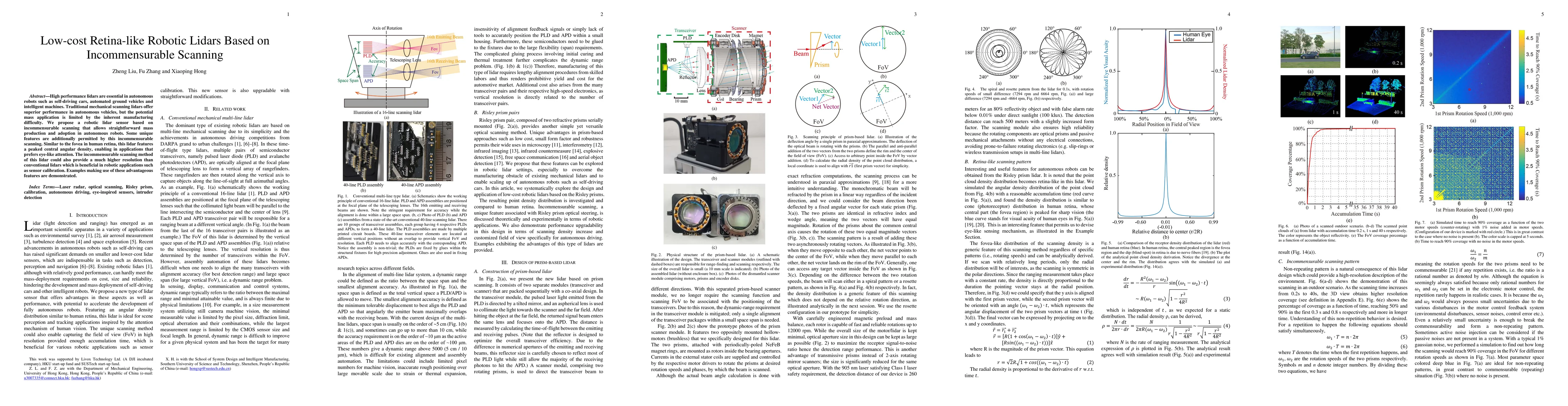
High performance lidars are essential in autonomous robots such as self-driving cars, automated ground vehicles and intelligent machines. Traditional mechanical scanning lidars offer superior perfor...
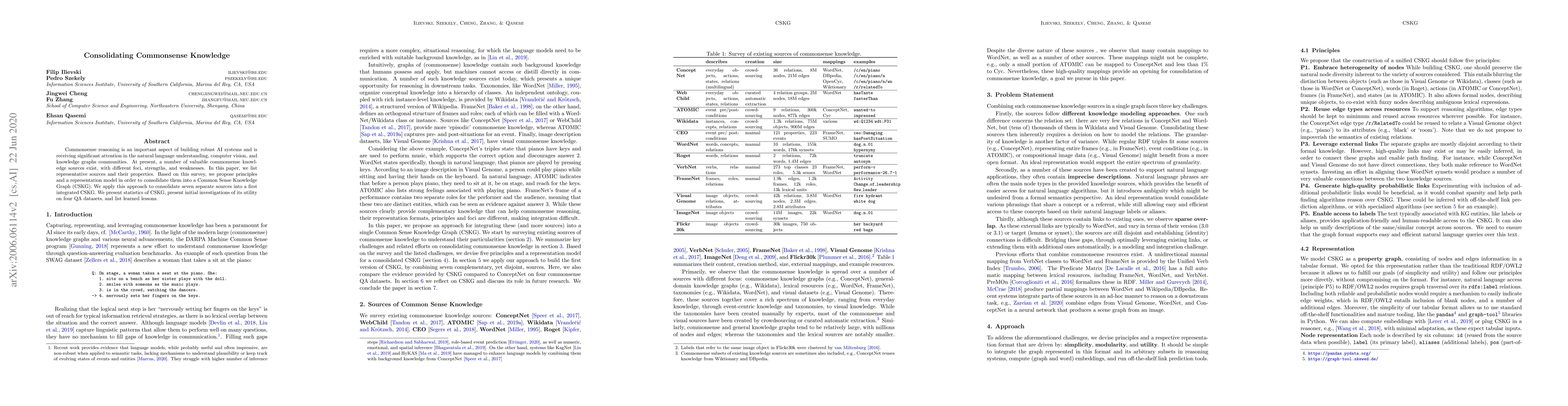
Commonsense reasoning is an important aspect of building robust AI systems and is receiving significant attention in the natural language understanding, computer vision, and knowledge graphs communi...
Dilute magnetic semiconductors, achieved through substitutional doping of spin-polarized transition metals into semiconducting systems, enable experimental modulation of spin dynamics in ways that h...
The outstanding optoelectronic and valleytronic properties of transition metal dichalcogenides (TMDs) have triggered intense research efforts by the scientific community. An alternative to induce lo...
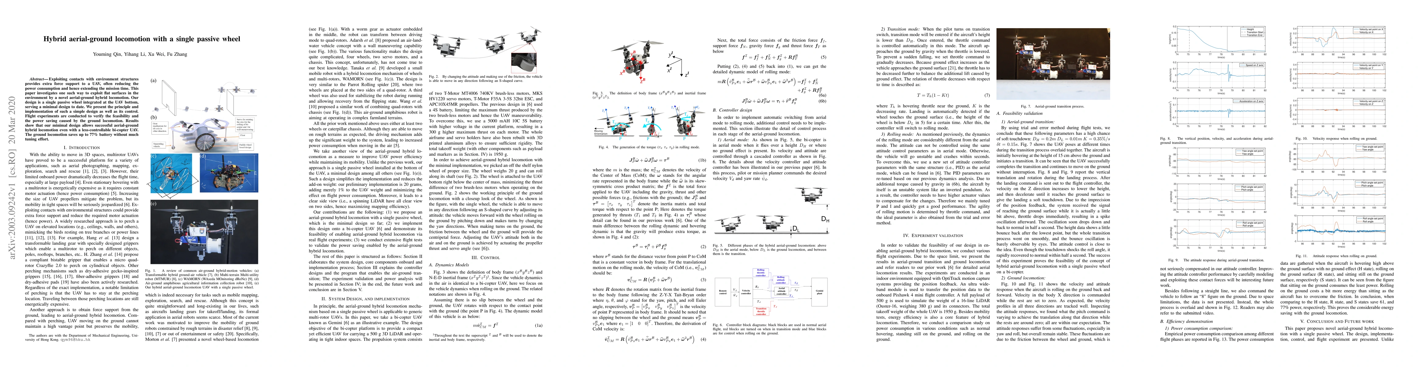
Exploiting contacts with environment structures provides extra force support to a UAV, often reducing the power consumption and hence extending the mission time. This paper investigates one such way...

This paper presents a loop closure method to correct the long-term drift in LiDAR odometry and mapping (LOAM). Our proposed method computes the 2D histogram of keyframes, a local map patch, and uses...
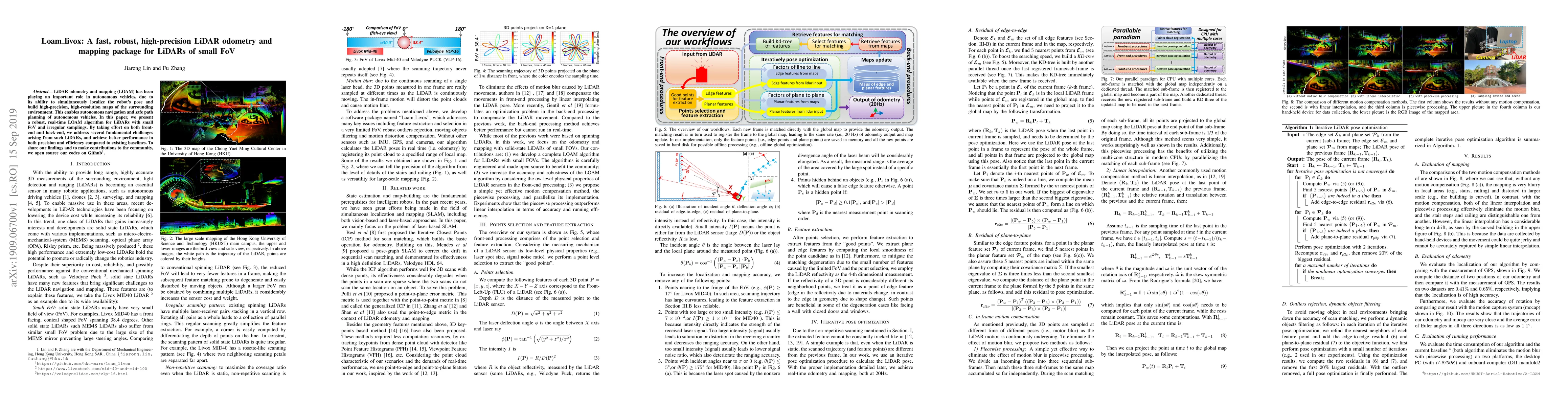
LiDAR odometry and mapping (LOAM) has been playing an important role in autonomous vehicles, due to its ability to simultaneously localize the robot's pose and build high-precision, high-resolution ...
This paper proves a Krylov-Safonov estimate for a multidimensional diffusion process whose diffusion coefficients are degenerate on the boundary. As applications the existence and uniqueness of inva...
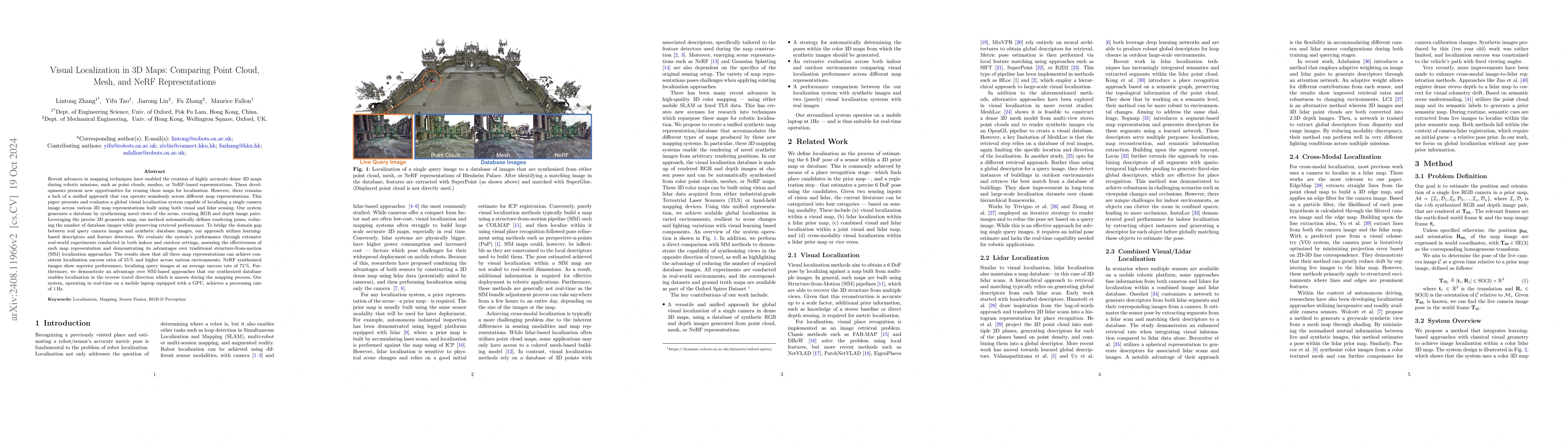
This paper introduces and assesses a cross-modal global visual localization system that can localize camera images within a color 3D map representation built using both visual and lidar sensing. We pr...
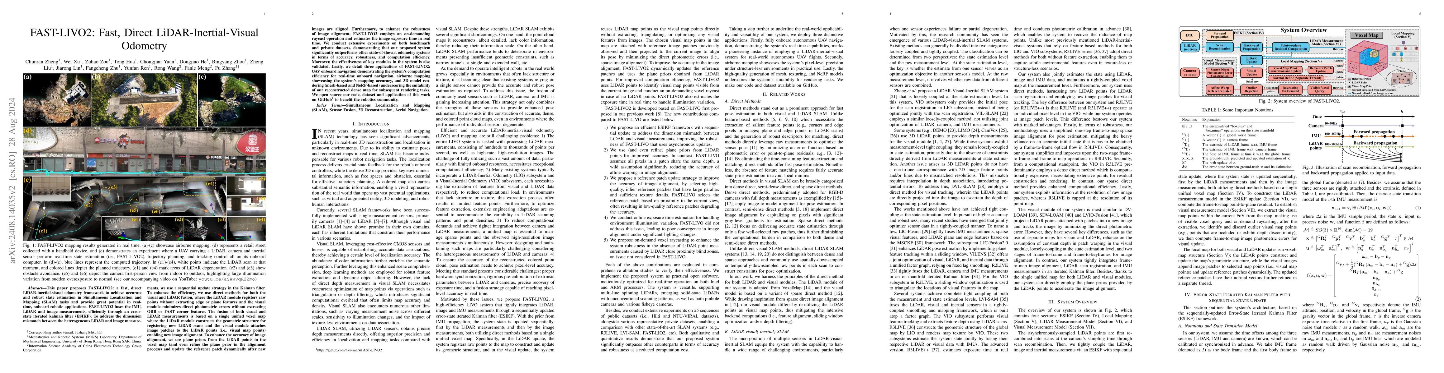
This paper proposes FAST-LIVO2: a fast, direct LiDAR-inertial-visual odometry framework to achieve accurate and robust state estimation in SLAM tasks and provide great potential in real-time, onboard ...
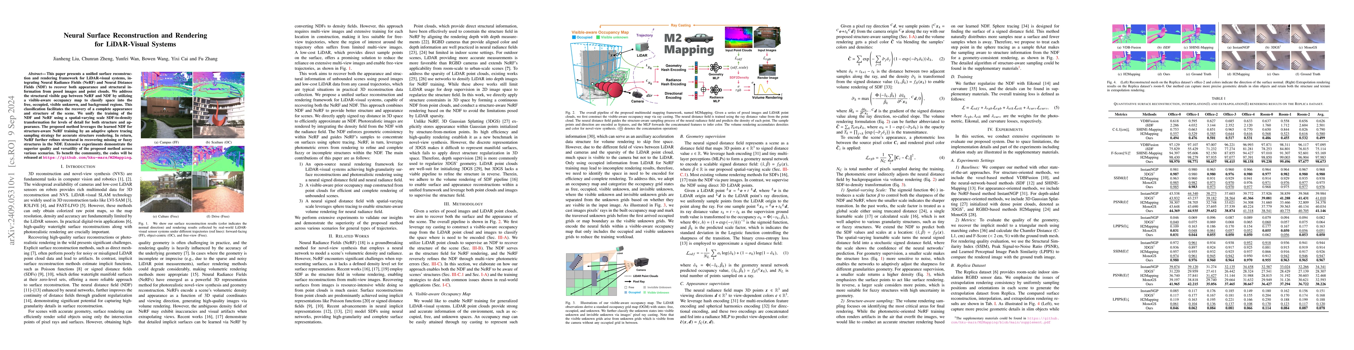
This paper presents a unified surface reconstruction and rendering framework for LiDAR-visual systems, integrating Neural Radiance Fields (NeRF) and Neural Distance Fields (NDF) to recover both appear...
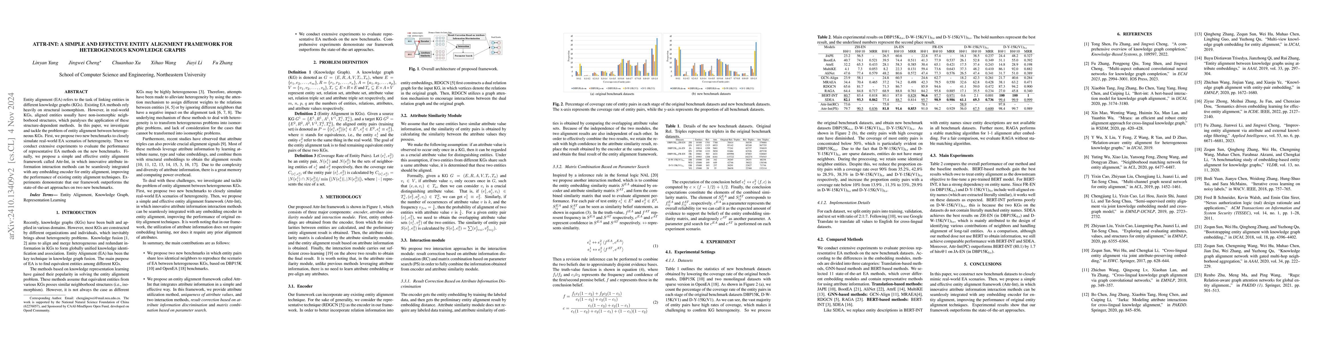
Entity alignment (EA) refers to the task of linking entities in different knowledge graphs (KGs). Existing EA methods rely heavily on structural isomorphism. However, in real-world KGs, aligned entiti...
The augmented Lagrange method is employed to address the optimal control problem involving pointwise state constraints in parabolic equations. The strong convergence of the primal variables and the we...
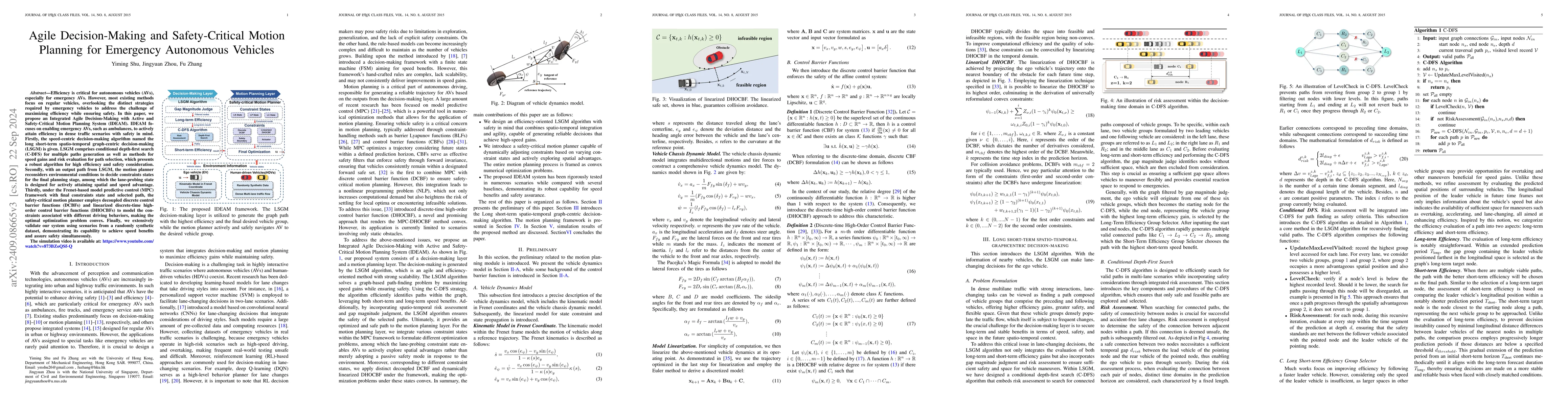
Efficiency is critical for autonomous vehicles (AVs), especially for emergency AVs. However, most existing methods focus on regular vehicles, overlooking the distinct strategies required by emergency ...
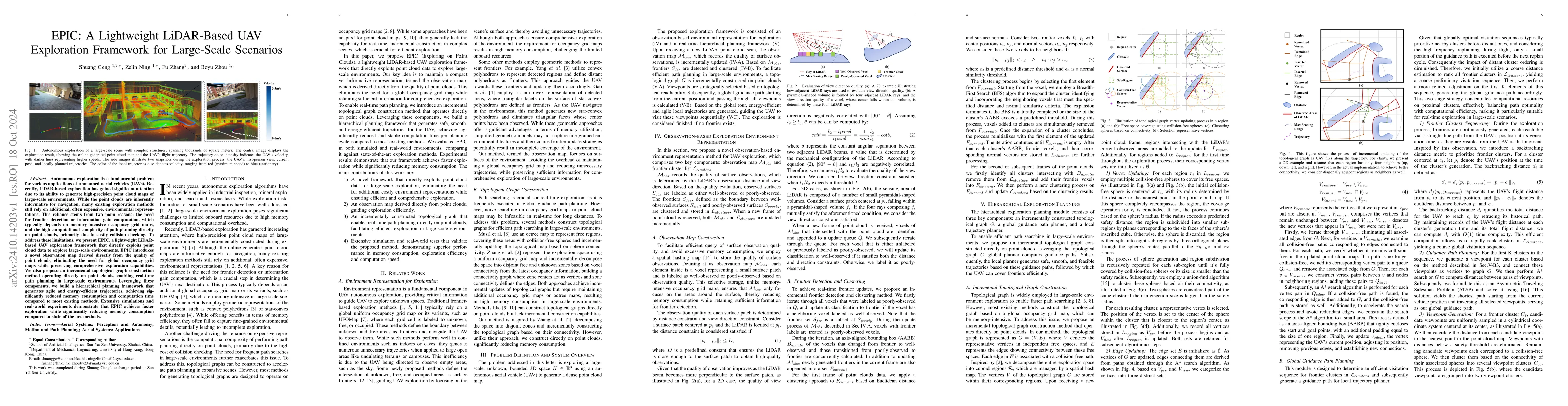
Autonomous exploration is a fundamental problem for various applications of unmanned aerial vehicles (UAVs). Recently, LiDAR-based exploration has gained significant attention due to its ability to ge...
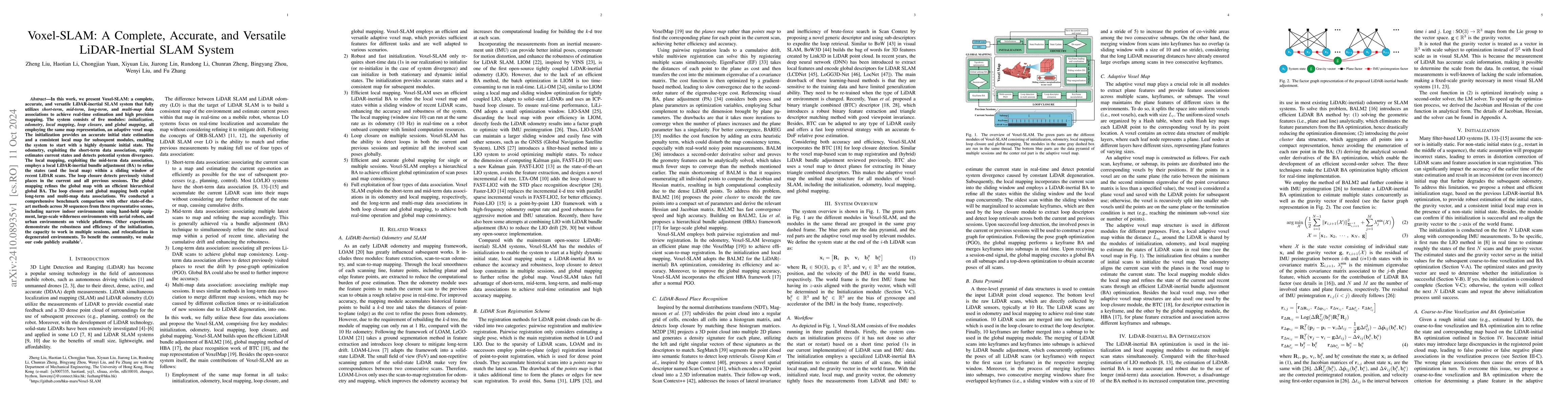
In this work, we present Voxel-SLAM: a complete, accurate, and versatile LiDAR-inertial SLAM system that fully utilizes short-term, mid-term, long-term, and multi-map data associations to achieve real...
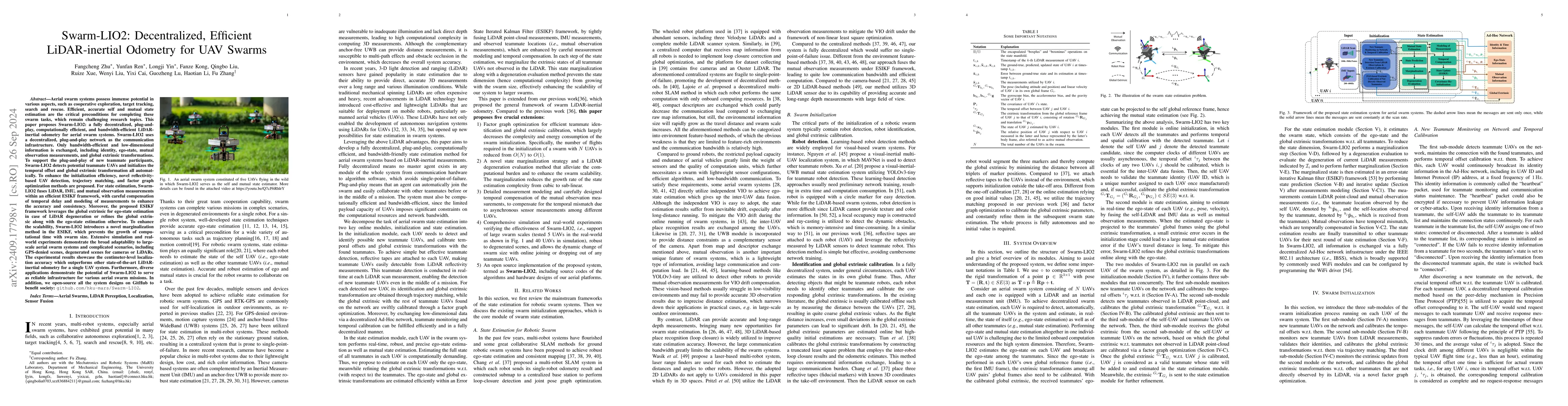
Aerial swarm systems possess immense potential in various aspects, such as cooperative exploration, target tracking, search and rescue. Efficient, accurate self and mutual state estimation are the cri...
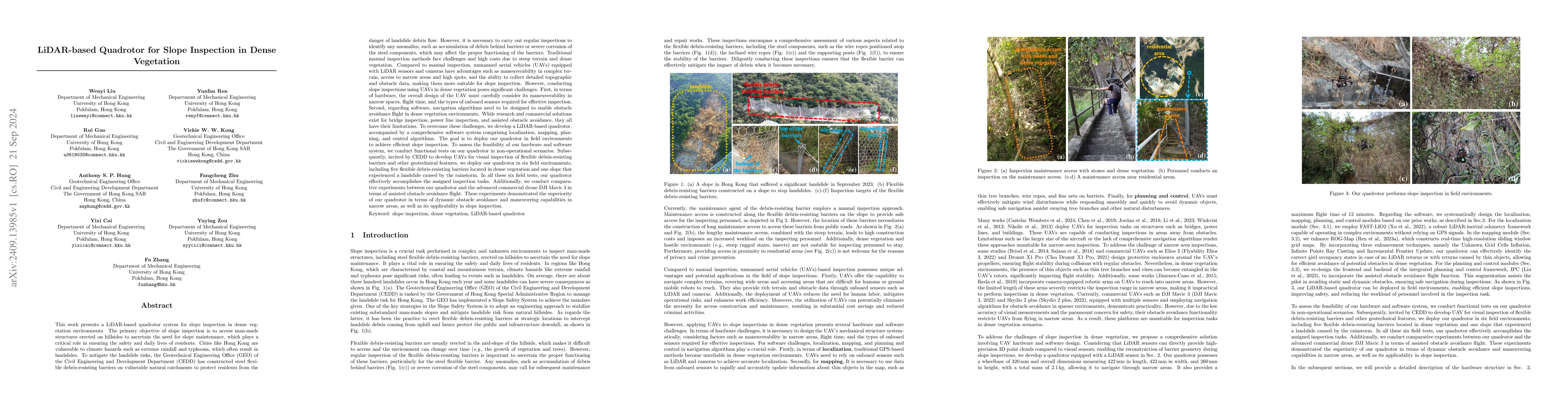
This work presents a LiDAR-based quadrotor system for slope inspection in dense vegetation environments. Cities like Hong Kong are vulnerable to climate hazards, which often result in landslides. To m...
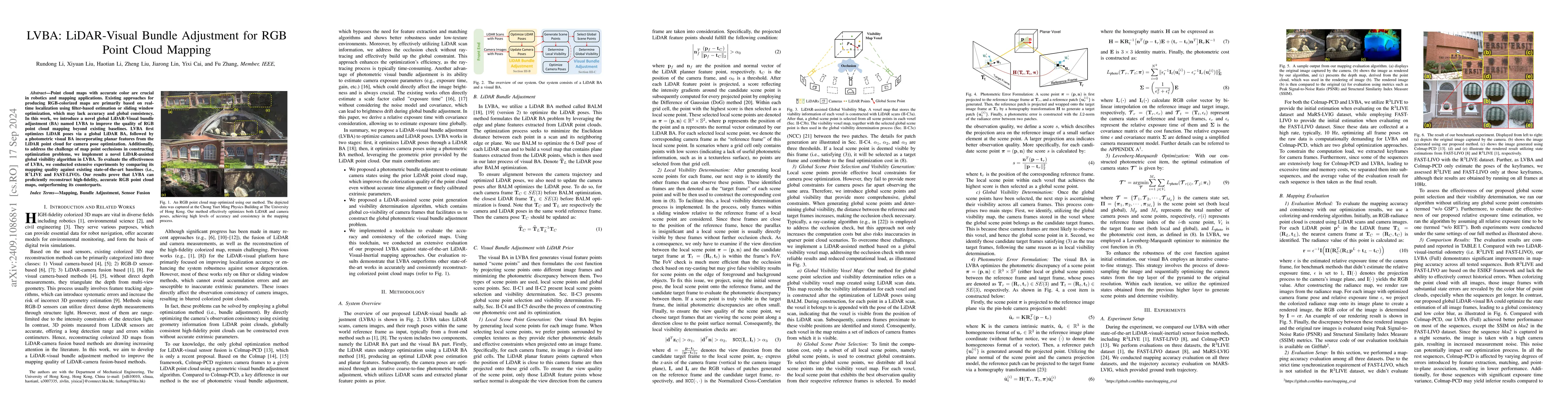
Point cloud maps with accurate color are crucial in robotics and mapping applications. Existing approaches for producing RGB-colorized maps are primarily based on real-time localization using filter-b...
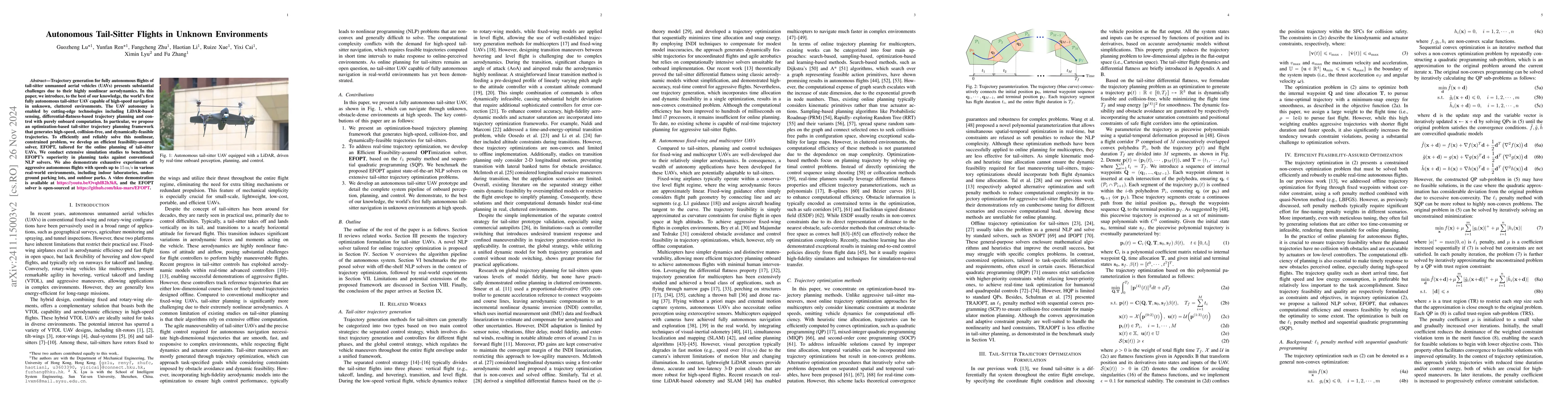
Trajectory generation for fully autonomous flights of tail-sitter unmanned aerial vehicles (UAVs) presents substantial challenges due to their highly nonlinear aerodynamics. In this paper, we introduc...
In recent years, some researchers have applied diffusion models to multivariate time series anomaly detection. The partial diffusion strategy, which depends on the diffusion steps, is commonly used fo...
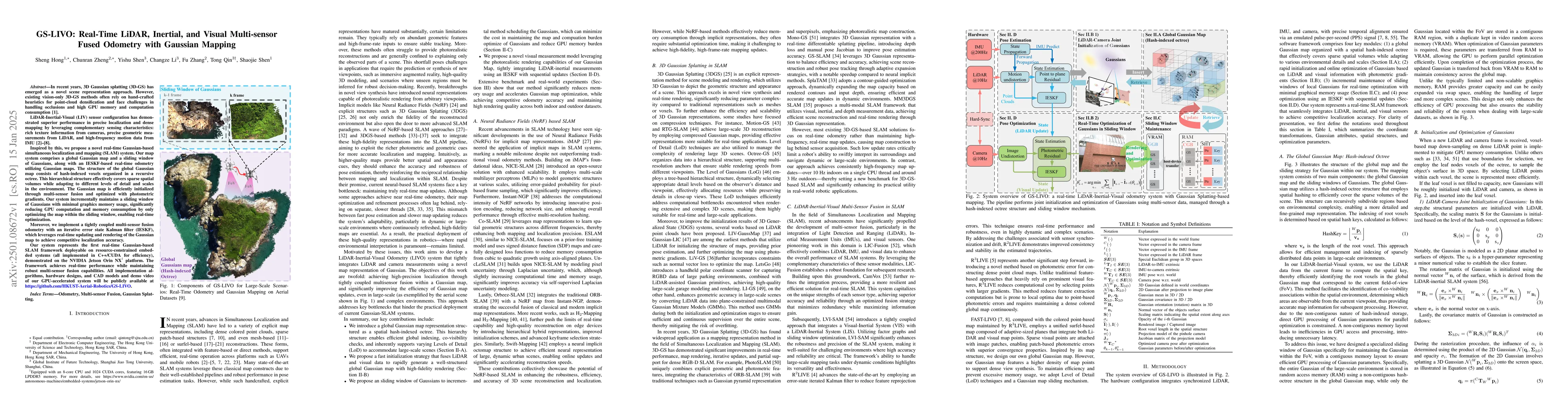
In recent years, 3D Gaussian splatting (3D-GS) has emerged as a novel scene representation approach. However, existing vision-only 3D-GS methods often rely on hand-crafted heuristics for point-cloud d...
This paper applies the Method of Successive Approximations (MSA) based on Pontryagin's principle to solve optimal control problems with state constraints for semilinear parabolic equations. Error esti...
This paper presents a lightweight LiDAR-inertial-visual odometry system optimized for resource-constrained platforms. It integrates a degeneration-aware adaptive visual frame selector into error-state...
Multi-interest candidate matching plays a pivotal role in personalized recommender systems, as it captures diverse user interests from their historical behaviors. Most existing methods utilize attenti...
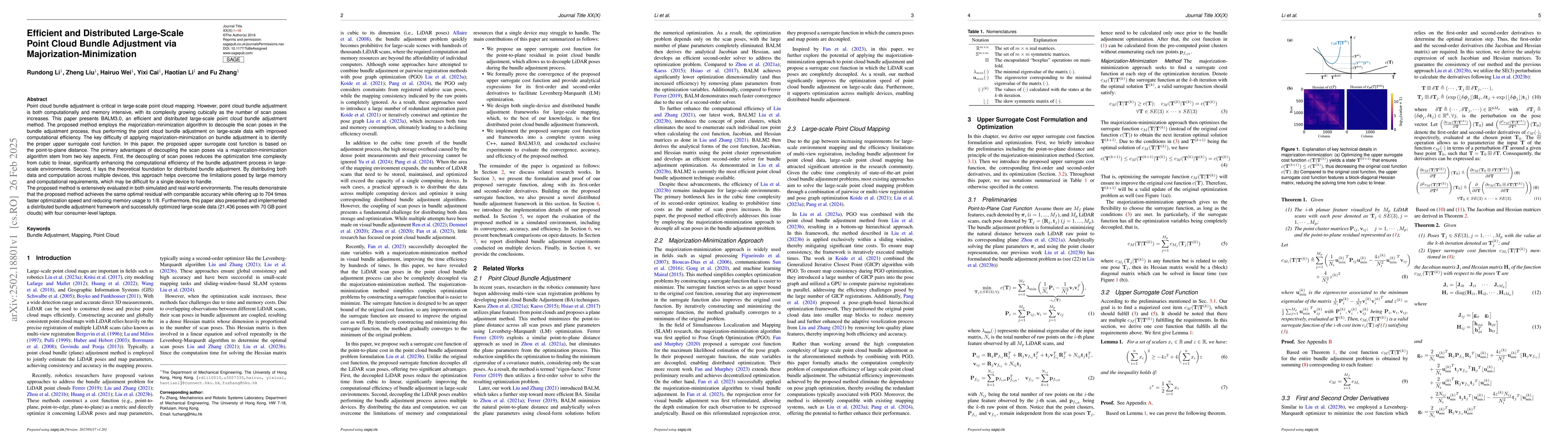
Point cloud bundle adjustment is critical in large-scale point cloud mapping. However, it is both computationally and memory intensive, with its complexity growing cubically as the number of scan pose...
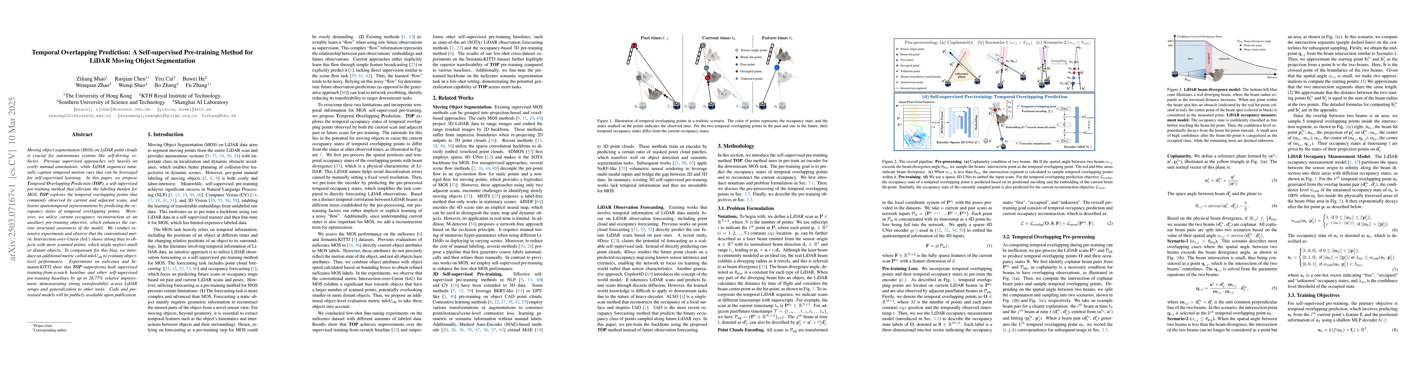
Moving object segmentation (MOS) on LiDAR point clouds is crucial for autonomous systems like self-driving vehicles. Previous supervised approaches rely heavily on costly manual annotations, while LiD...
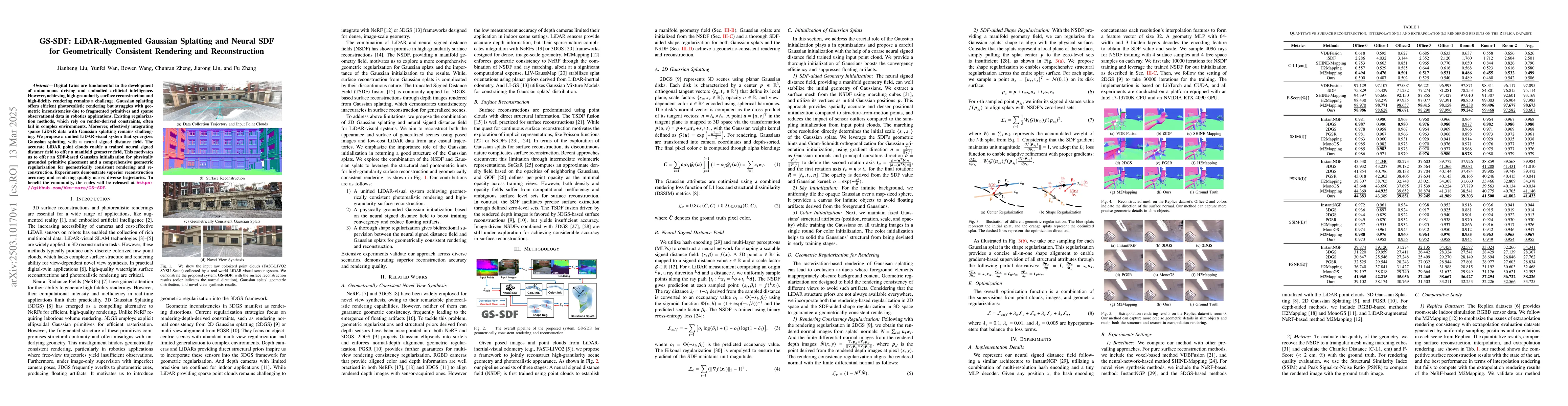
Digital twins are fundamental to the development of autonomous driving and embodied artificial intelligence. However, achieving high-granularity surface reconstruction and high-fidelity rendering rema...
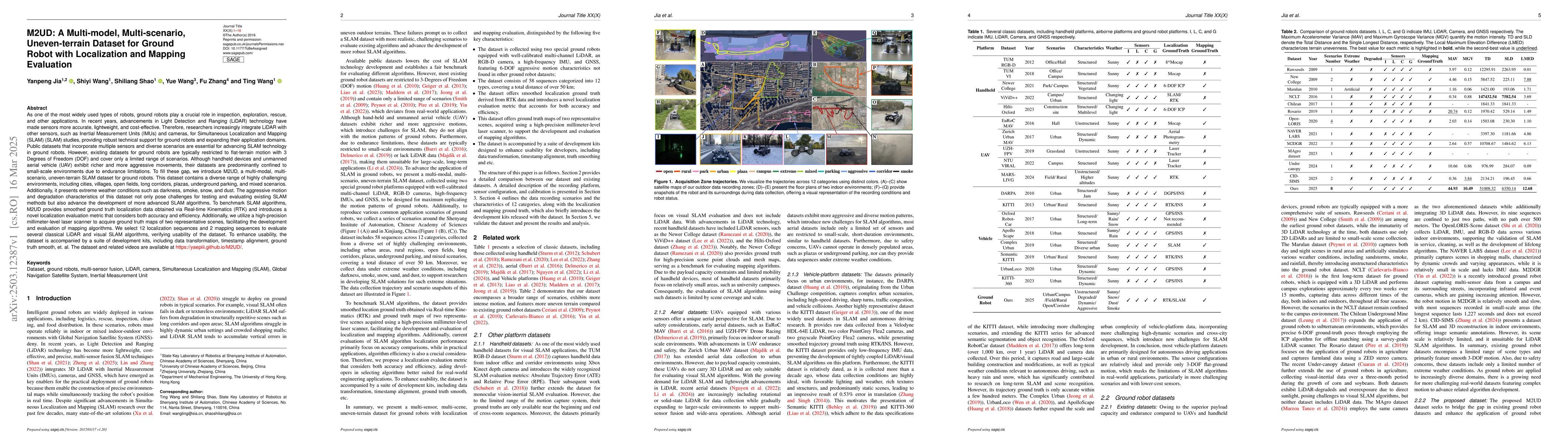
Ground robots play a crucial role in inspection, exploration, rescue, and other applications. In recent years, advancements in LiDAR technology have made sensors more accurate, lightweight, and cost-e...
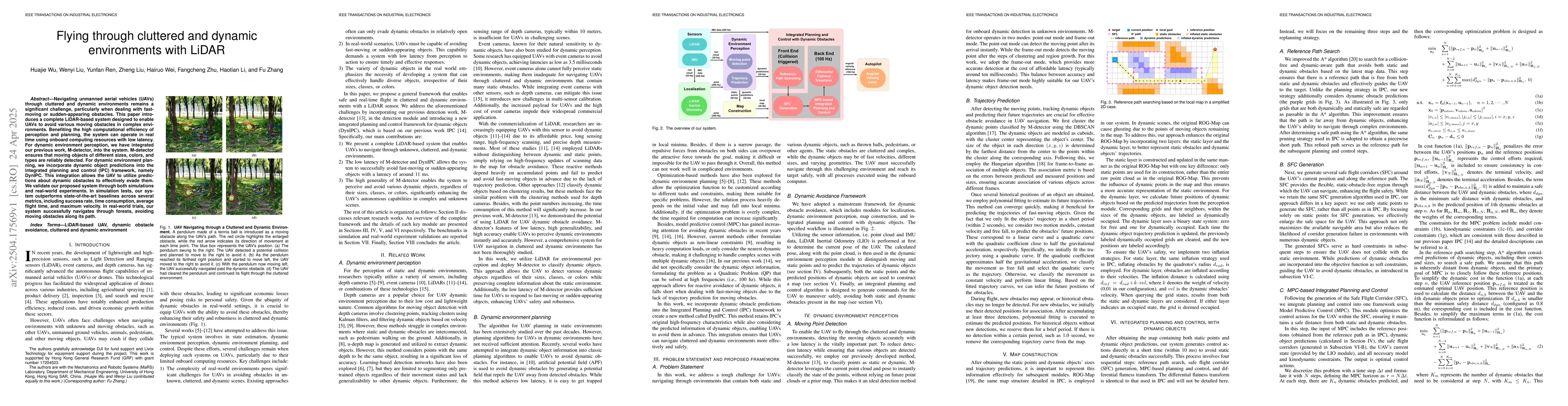
Navigating unmanned aerial vehicles (UAVs) through cluttered and dynamic environments remains a significant challenge, particularly when dealing with fast-moving or sudden-appearing obstacles. This pa...
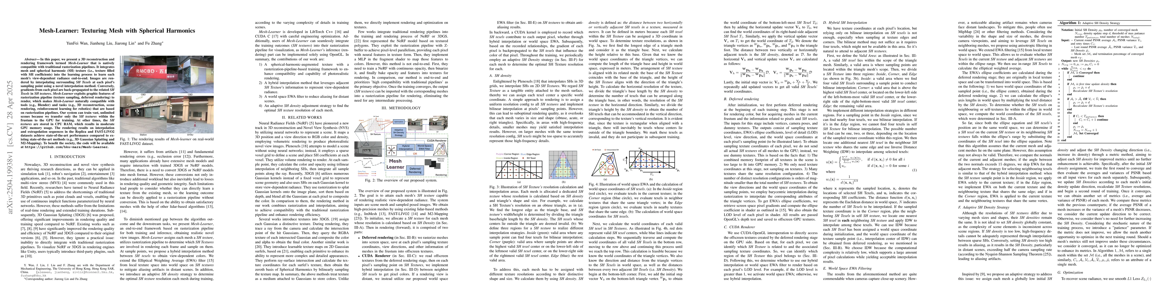
In this paper, we present a 3D reconstruction and rendering framework termed Mesh-Learner that is natively compatible with traditional rasterization pipelines. It integrates mesh and spherical harmoni...
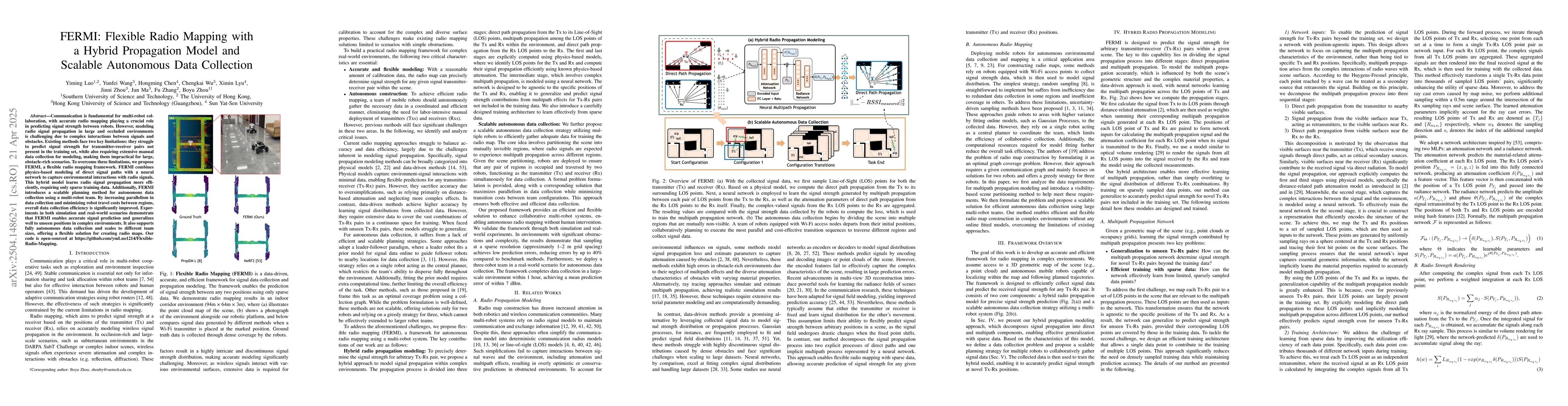
Communication is fundamental for multi-robot collaboration, with accurate radio mapping playing a crucial role in predicting signal strength between robots. However, modeling radio signal propagation ...
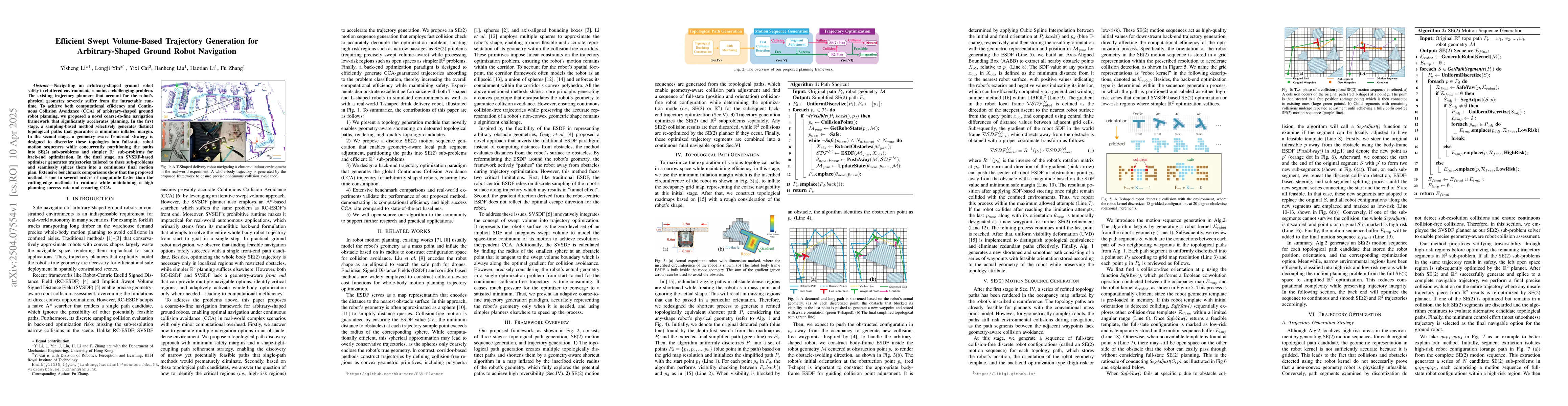
Navigating an arbitrary-shaped ground robot safely in cluttered environments remains a challenging problem. The existing trajectory planners that account for the robot's physical geometry severely suf...
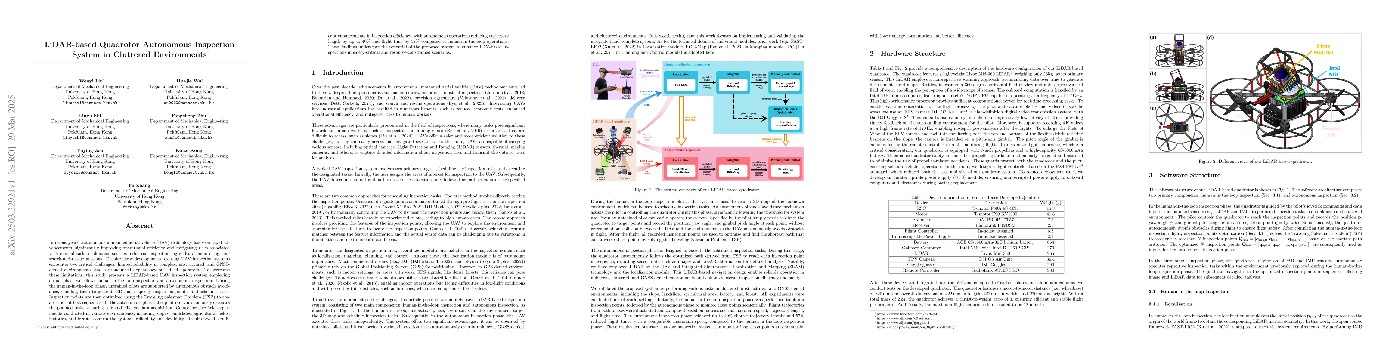
In recent years, autonomous unmanned aerial vehicle (UAV) technology has seen rapid advancements, significantly improving operational efficiency and mitigating risks associated with manual tasks in do...
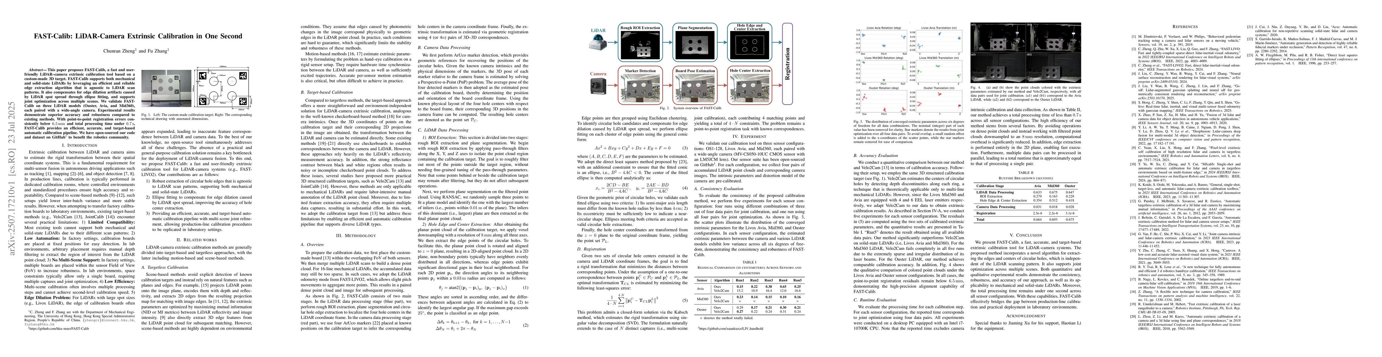
This paper proposes FAST-Calib, a fast and user-friendly LiDAR-camera extrinsic calibration tool based on a custom-made 3D target. FAST-Calib supports both mechanical and solid-state LiDARs by leverag...
This survey offers a comprehensive overview of recent advancements in LiDAR-based autonomous Unmanned Aerial Vehicles (UAVs), covering their design, perception, planning, and control strategies. Over ...
In the current era of big data, extracting deep insights from massive, heterogeneous, and complexly associated multi-dimensional data has become a significant challenge. Large Language Models (LLMs) p...
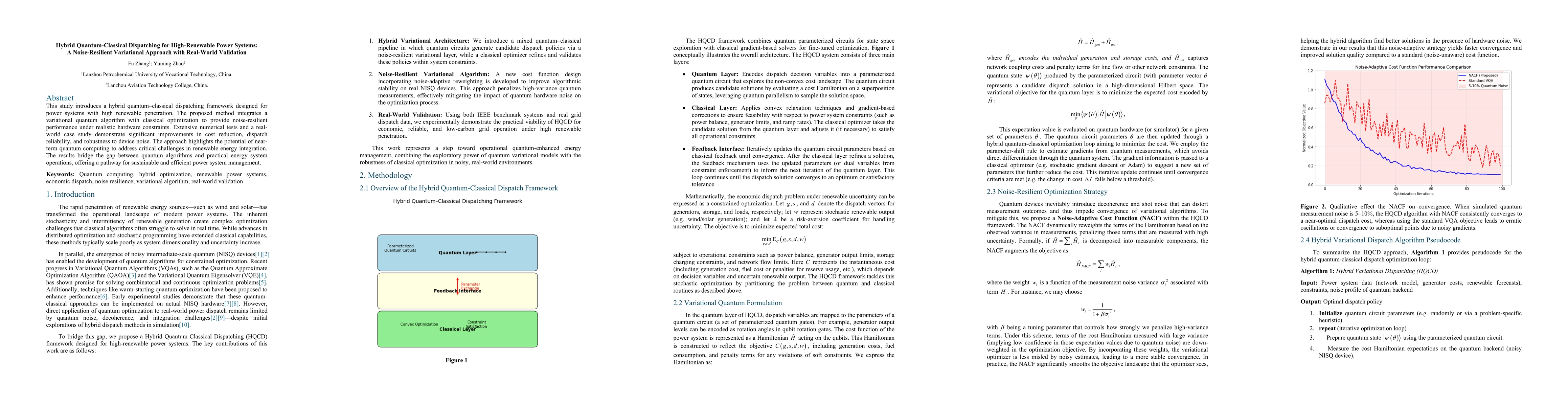
This study introduces a hybrid quantum-classical dispatching framework designed for power systems with high renewable penetration. The proposed method integrates a variational quantum algorithm with c...
Autonomous aerial tracking with drones offers vast potential for surveillance, cinematography, and industrial inspection applications. While single-drone tracking systems have been extensively studied...
Deep learning advances have enabled accurate six-degree-of-freedom (6DoF) object pose estimation, widely used in robotics, AR/VR, and autonomous systems. However, backdoor attacks pose significant sec...
This paper systematically investigates the optimal harvesting of a stochastic Lotka-Volterra competition model with periodic coefficients. Sufficient conditions for the extinction and persistence in t...
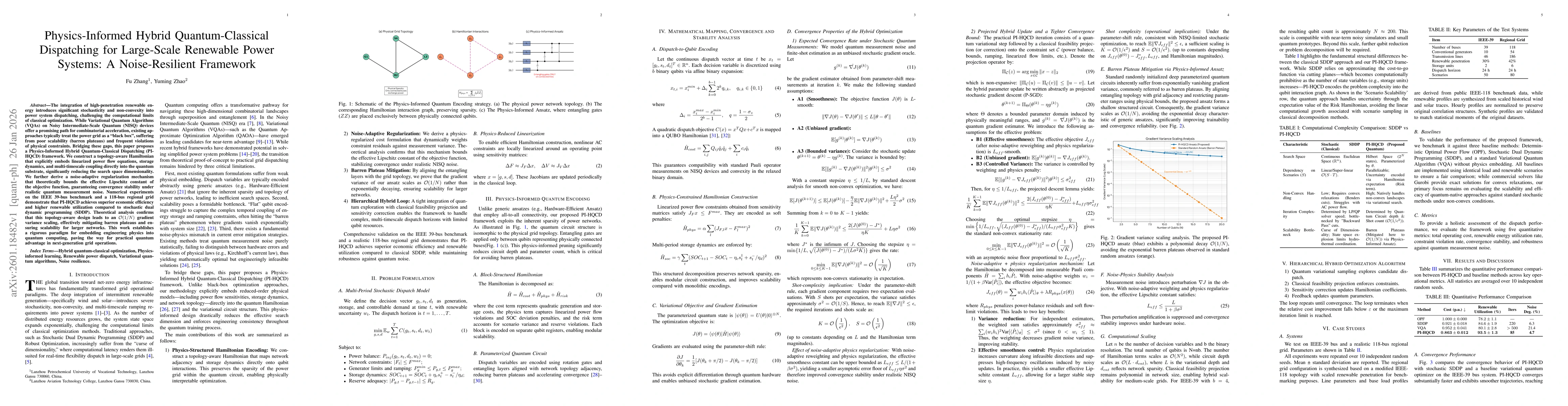
The integration of high-penetration renewable energy introduces significant stochasticity and non-convexity into power system dispatching, challenging the computational limits of classical optimizatio...
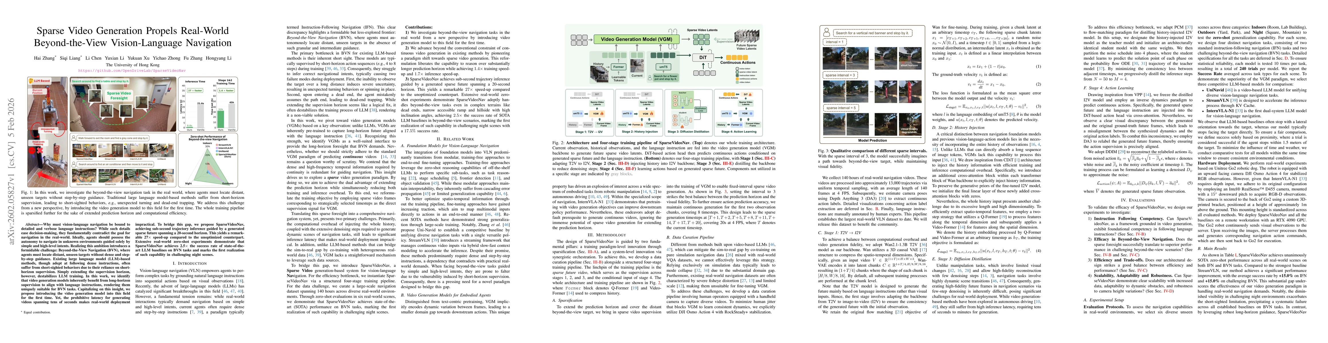
Why must vision-language navigation be bound to detailed and verbose language instructions? While such details ease decision-making, they fundamentally contradict the goal for navigation in the real-w...
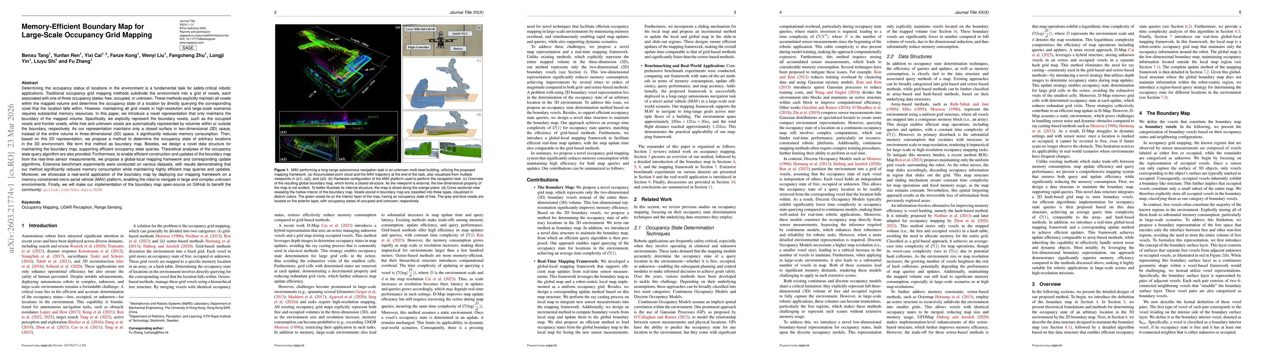
Determining the occupancy status of locations in the environment is a fundamental task for safety-critical robotic applications. Traditional occupancy grid mapping methods subdivide the environment in...
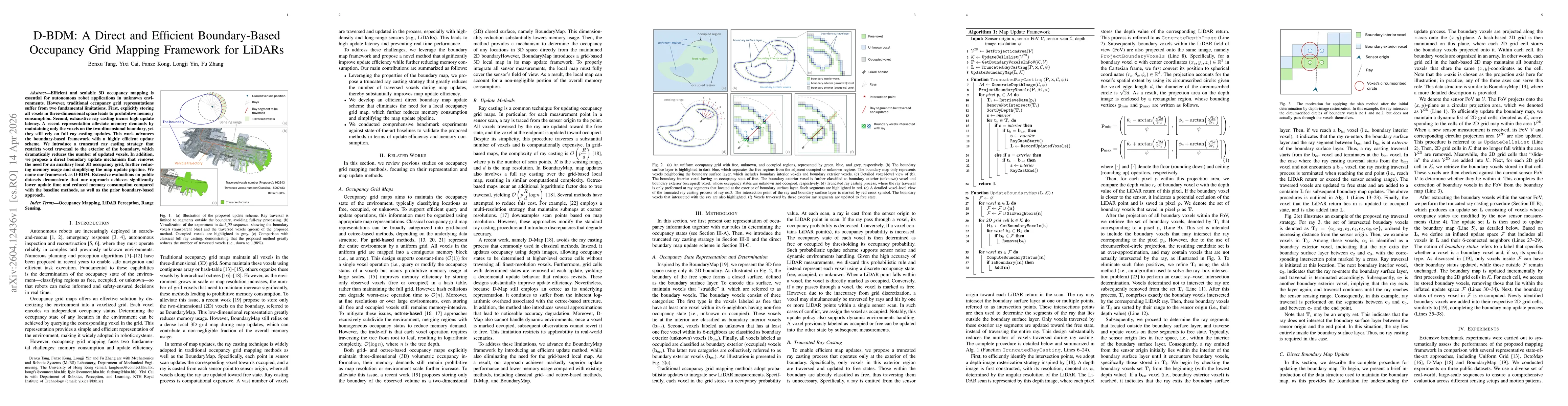
Efficient and scalable 3D occupancy mapping is essential for autonomous robot applications in unknown environments. However, traditional occupancy grid representations suffer from two fundamental limi...
This paper investigates a class of stochastic Logistic harvesting models driven by tempered stable processes, with a one-sided power-law Lévy measure. We establish threshold conditions for population ...