ArxivLens
C
Researcher

Clifford Broni-Bediako

10 papers on arXiv

10 arXiv Papers
14 Total Publications
Profile

Academic Profile

Name Clifford Broni-Bediako
Total Papers 14
Scholar Profile View on Semantic Scholar
Metrics

Statistics

10 arXiv Papers
14 Total Publications
Publications

Papers on arXiv

Thumbnail for ObjFormer: Learning Land-Cover Changes From Paired OSM Data and Optical
  High-Resolution Imagery via Object-Guided Transformer
arXiv
ObjFormer: Learning Land-Cover Changes From Paired OSM Data and Optical High-Resolution Imagery via Object-Guided Transformer

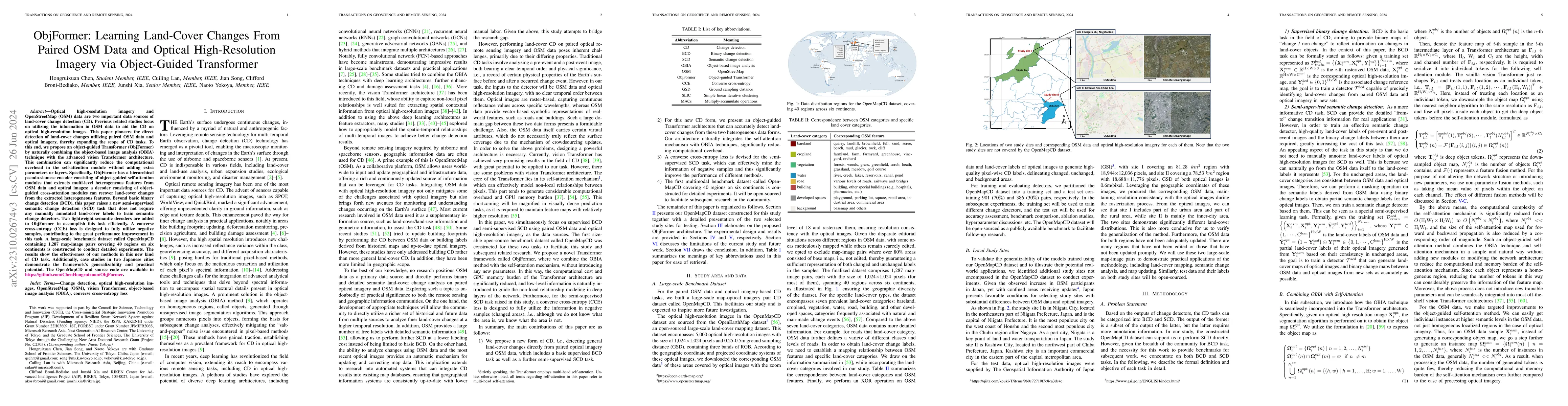
Optical high-resolution imagery and OSM data are two important data sources of change detection (CD). Previous related studies focus on utilizing the information in OSM data to aid the CD on optical h...

Thumbnail for Unsupervised Domain Adaptation Architecture Search with Self-Training
  for Land Cover Mapping
arXiv
Unsupervised Domain Adaptation Architecture Search with Self-Training for Land Cover Mapping

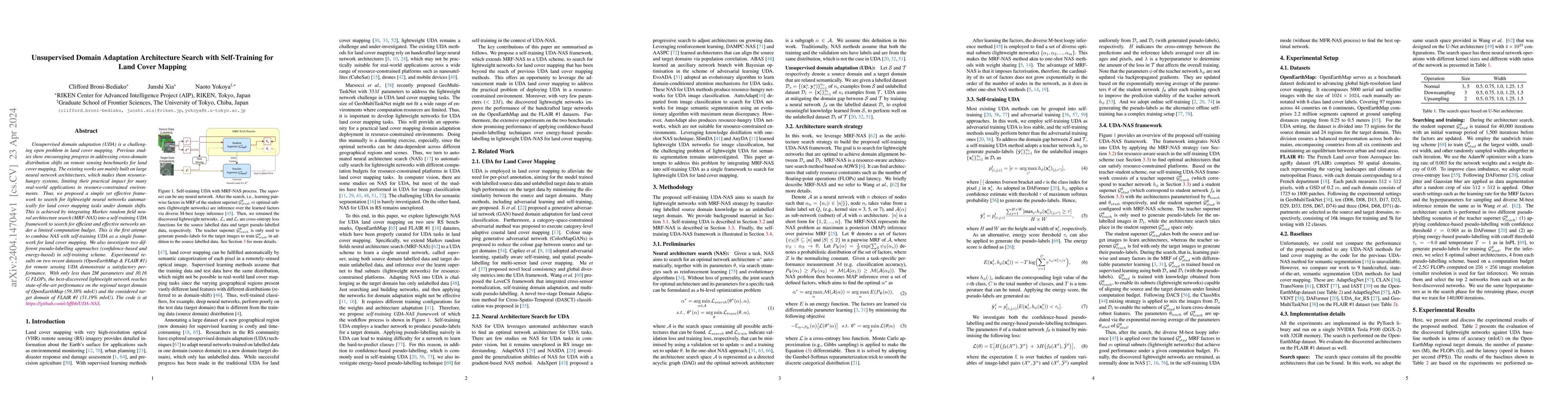
Unsupervised domain adaptation (UDA) is a challenging open problem in land cover mapping. Previous studies show encouraging progress in addressing cross-domain distribution shifts on remote sensing ...

Thumbnail for A Survey on African Computer Vision Datasets, Topics and Researchers
arXiv
A Survey on African Computer Vision Datasets, Topics and Researchers

Computer vision encompasses a range of tasks such as object detection, semantic segmentation, and 3D reconstruction. Despite its relevance to African communities, research in this field within Afric...

Thumbnail for Submeter-level Land Cover Mapping of Japan
arXiv
Submeter-level Land Cover Mapping of Japan

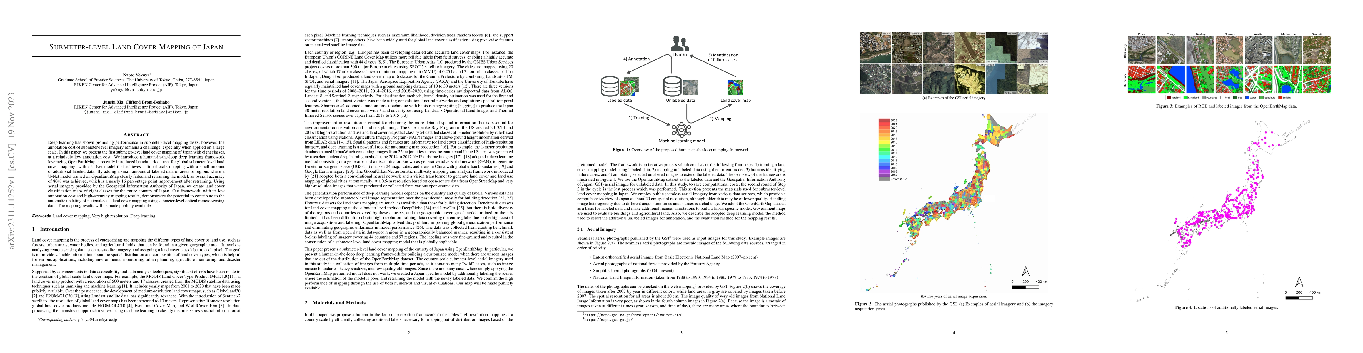
Deep learning has shown promising performance in submeter-level mapping tasks; however, the annotation cost of submeter-level imagery remains a challenge, especially when applied on a large scale. I...

Thumbnail for Real-Time Semantic Segmentation: A Brief Survey & Comparative Study in
  Remote Sensing
arXiv
Real-Time Semantic Segmentation: A Brief Survey & Comparative Study in Remote Sensing

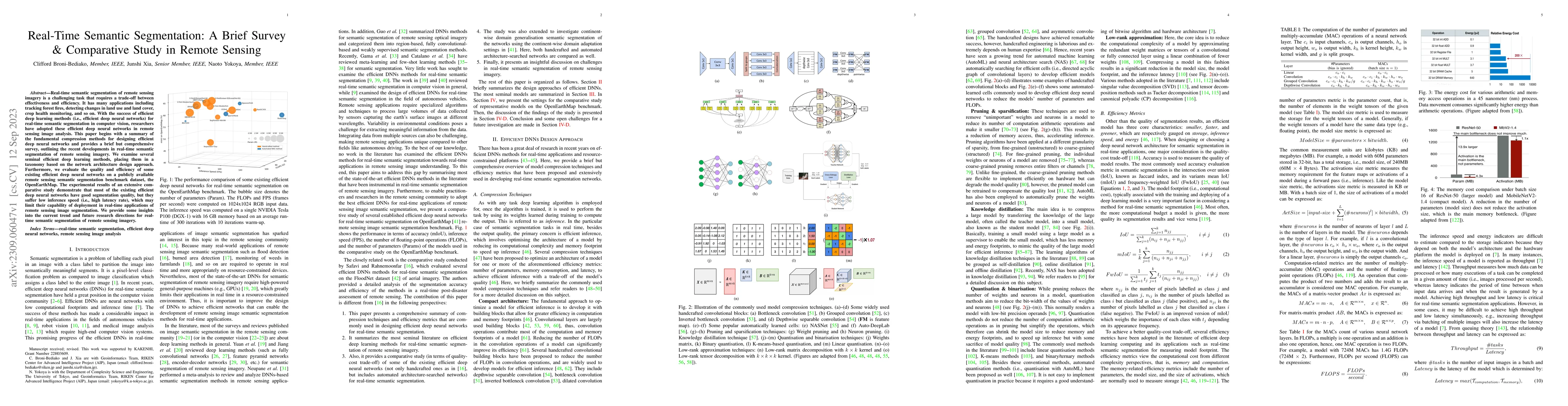
Real-time semantic segmentation of remote sensing imagery is a challenging task that requires a trade-off between effectiveness and efficiency. It has many applications including tracking forest fir...

Thumbnail for OpenEarthMap: A Benchmark Dataset for Global High-Resolution Land Cover
  Mapping
arXiv
OpenEarthMap: A Benchmark Dataset for Global High-Resolution Land Cover Mapping

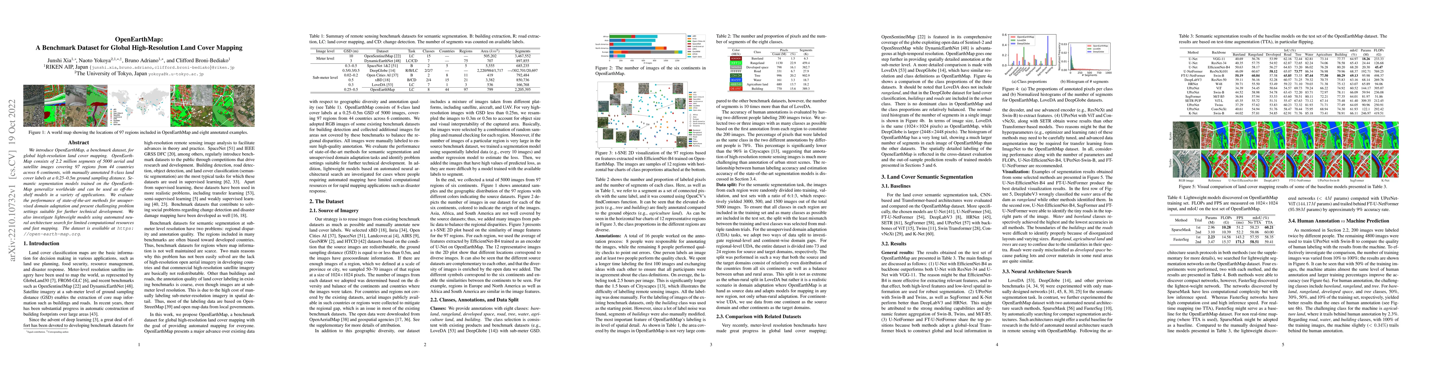
We introduce OpenEarthMap, a benchmark dataset, for global high-resolution land cover mapping. OpenEarthMap consists of 2.2 million segments of 5000 aerial and satellite images covering 97 regions f...

Thumbnail for Evolutionary NAS with Gene Expression Programming of Cellular Encoding
arXiv
Evolutionary NAS with Gene Expression Programming of Cellular Encoding

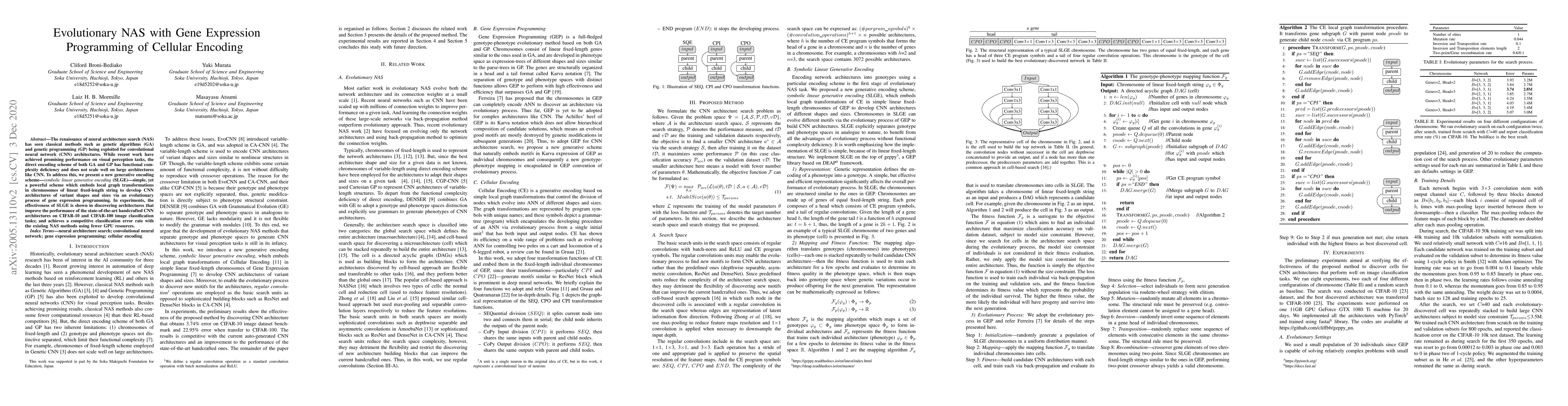
The renaissance of neural architecture search (NAS) has seen classical methods such as genetic algorithms (GA) and genetic programming (GP) being exploited for convolutional neural network (CNN) arc...

Thumbnail for Generalized Few-Shot Semantic Segmentation in Remote Sensing: Challenge
  and Benchmark
arXiv
Generalized Few-Shot Semantic Segmentation in Remote Sensing: Challenge and Benchmark

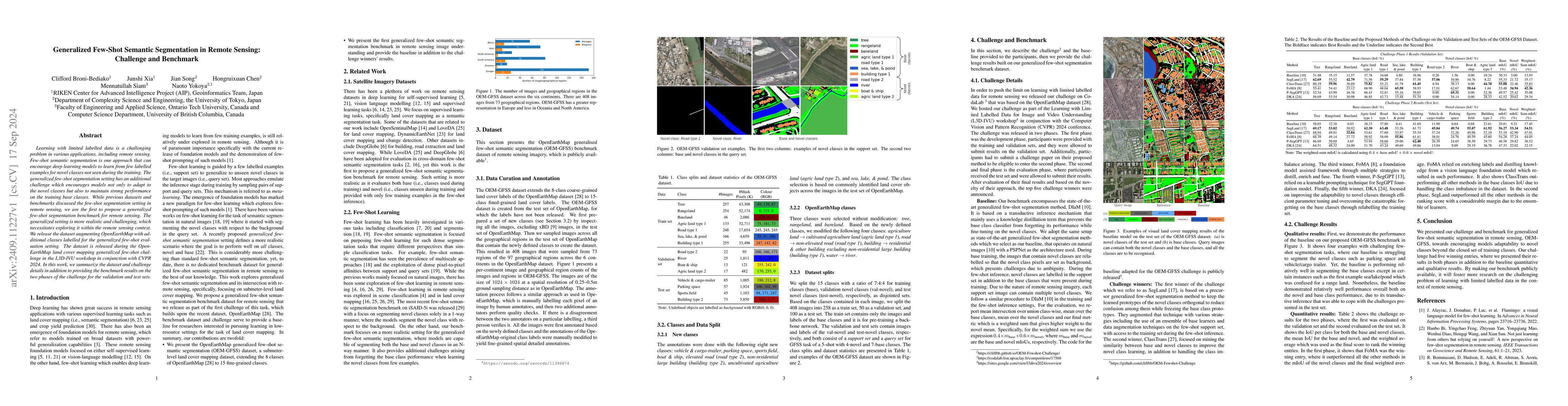
Learning with limited labelled data is a challenging problem in various applications, including remote sensing. Few-shot semantic segmentation is one approach that can encourage deep learning models t...

Thumbnail for BRIGHT: A globally distributed multimodal building damage assessment
  dataset with very-high-resolution for all-weather disaster response
arXiv
BRIGHT: A globally distributed multimodal building damage assessment dataset with very-high-resolution for all-weather disaster response

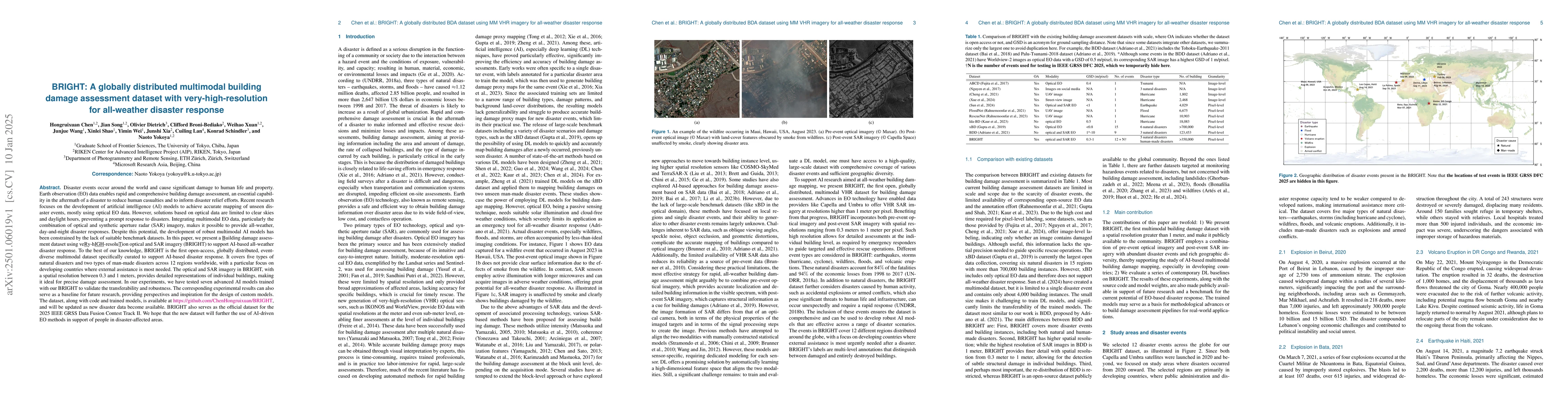
Disaster events occur around the world and cause significant damage to human life and property. Earth observation (EO) data enables rapid and comprehensive building damage assessment (BDA), an essenti...

Thumbnail for OpenEarthMap-SAR: A Benchmark Synthetic Aperture Radar Dataset for
  Global High-Resolution Land Cover Mapping
arXiv
OpenEarthMap-SAR: A Benchmark Synthetic Aperture Radar Dataset for Global High-Resolution Land Cover Mapping

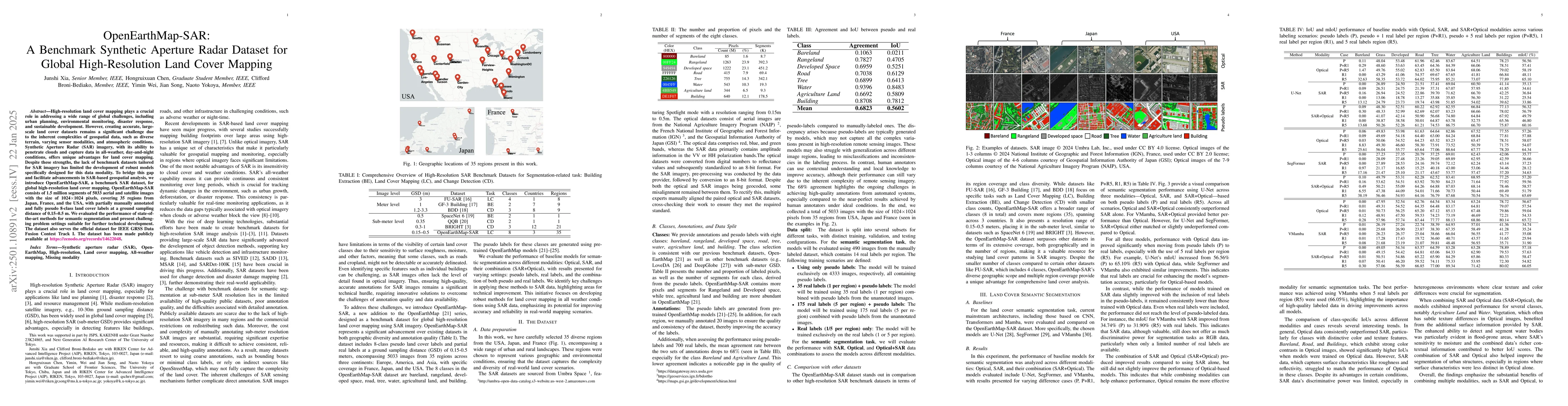
High-resolution land cover mapping plays a crucial role in addressing a wide range of global challenges, including urban planning, environmental monitoring, disaster response, and sustainable developm...

This website uses cookies to ensure you get the best experience. Learn more