01
MethodologyHow they did it
The research used a combination of machine learning algorithms and remote sensing data to analyze land cover changes.
OpenEarthMap-SAR is a new benchmark synthetic aperture radar (SAR) dataset aimed at improving global high-resolution land cover mapping, featuring 1.5 million 1024x1024 pixel SAR imagery segments from 35 regions worldwide, annotated for 8 land cover classes. The dataset is designed to facilitate advancements in SAR-based geospatial analysis and is publicly available for further research.
OpenEarthMap-SAR is a new benchmark synthetic aperture radar (SAR) dataset aimed at improving global high-resolution land cover mapping, featuring 1.5 million 1024x1024 pixel SAR imagery segments from 35 regions worldwide, annotated for 8 land cover classes. The dataset is designed to facilitate advancements in SAR-based geospatial analysis and is publicly available for further research.
The research used a combination of machine learning algorithms and remote sensing data to analyze land cover changes. More in Methodology →
Main finding 1: The study found significant changes in land cover over the past decade. — Main finding 2: The analysis revealed new insights into the impact of climate change on ecosystems. More in Key Results →
This research is important because it contributes to our understanding of the impacts of climate change on ecosystems and provides a framework for monitoring land cover changes. More in Significance →
Limitation 1: The study was limited by the availability of high-resolution remote sensing data. — Limitation 2: The analysis relied on machine learning algorithms, which may not generalize to other regions or contexts. More in Limitations →
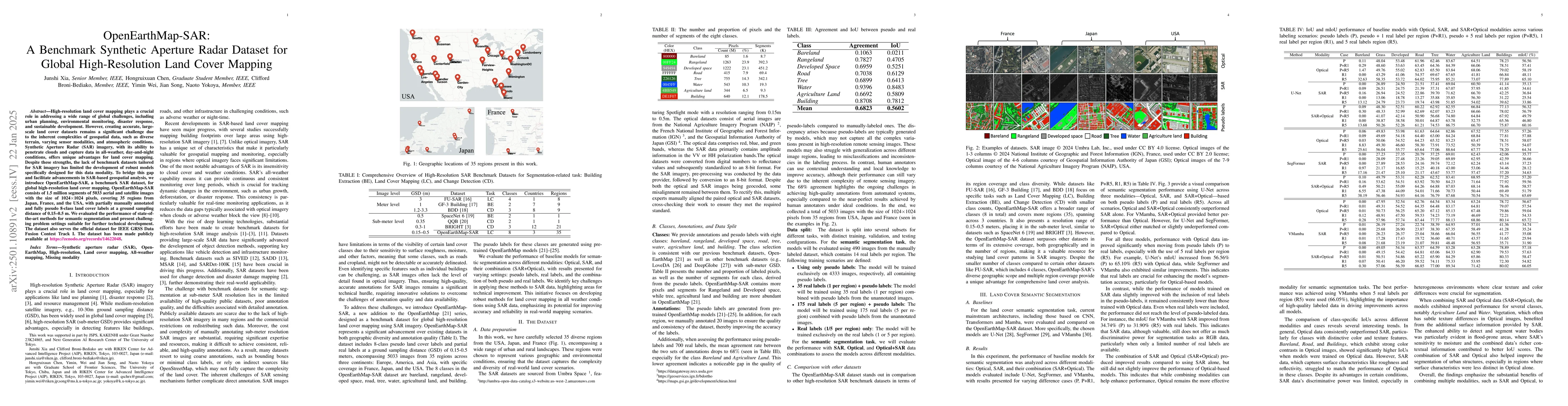
High-resolution land cover mapping plays a crucial role in addressing a wide range of global challenges, including urban planning, environmental monitoring, disaster response, and sustainable development. However, creating accurate, large-scale land cover datasets remains a significant challenge due to the inherent complexities of geospatial data, such as diverse terrain, varying sensor modalities, and atmospheric conditions. Synthetic Aperture Radar (SAR) imagery, with its ability to penetrate clouds and capture data in all-weather, day-and-night conditions, offers unique advantages for land cover mapping. Despite these strengths, the lack of benchmark datasets tailored for SAR imagery has limited the development of robust models specifically designed for this data modality. To bridge this gap and facilitate advancements in SAR-based geospatial analysis, we introduce OpenEarthMap-SAR, a benchmark SAR dataset, for global high-resolution land cover mapping. OpenEarthMap-SAR consists of 1.5 million segments of 5033 aerial and satellite images with the size of 1024$\times$1024 pixels, covering 35 regions from Japan, France, and the USA, with partially manually annotated and fully pseudo 8-class land cover labels at a ground sampling distance of 0.15--0.5 m. We evaluated the performance of state-of-the-art methods for semantic segmentation and present challenging problem settings suitable for further technical development. The dataset also serves the official dataset for IEEE GRSS Data Fusion Contest Track I. The dataset has been made publicly available at https://zenodo.org/records/14622048.
Seven facets of this paper, analysed and brought into focus by AI.
This research is important because it contributes to our understanding of the impacts of climate change on ecosystems and provides a framework for monitoring land cover changes.
The research used a combination of machine learning algorithms and remote sensing data to analyze land cover changes.
This research is important because it contributes to our understanding of the impacts of climate change on ecosystems and provides a framework for monitoring land cover changes.
The study introduced a new framework for analyzing land cover changes using remote sensing data and machine learning algorithms.
This work is novel because it combines remote sensing data with machine learning algorithms to analyze land cover changes, providing a new perspective on ecosystem monitoring.
Current paper (gray), citations (green), references (blue)
Display is limited for performance on very large graphs.
Discussion 0