Academic Profile
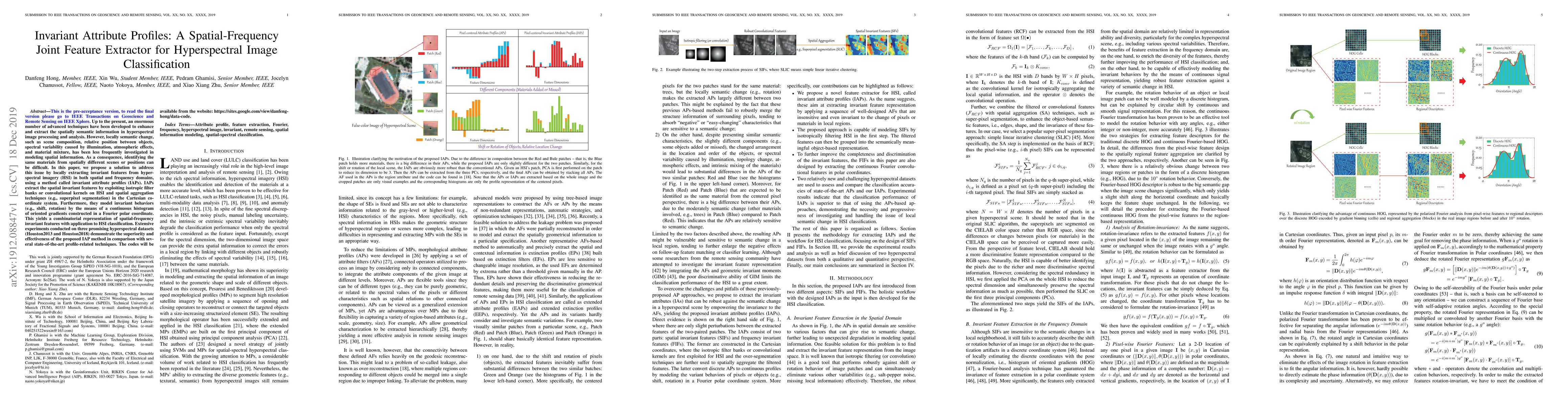
Statistics
Similar Authors
Papers on arXiv
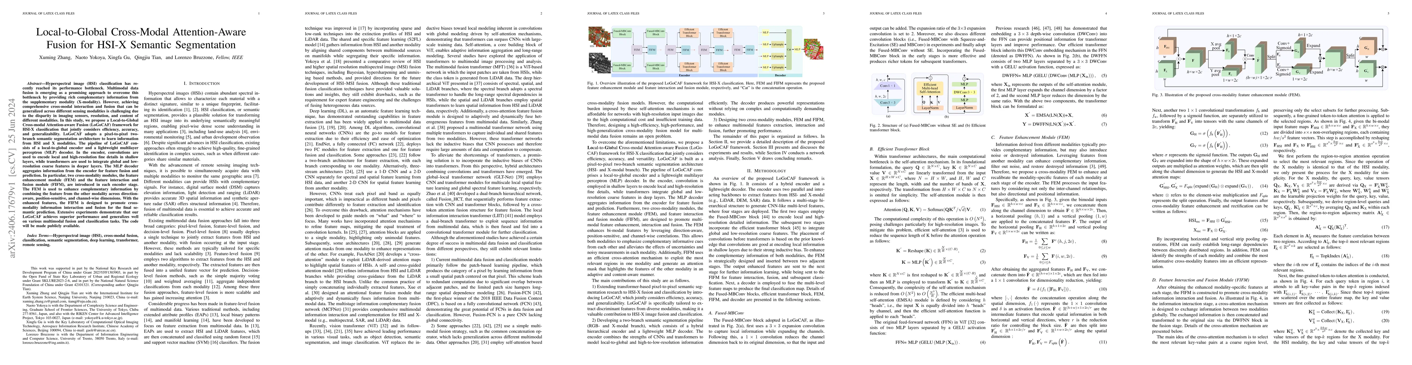
Hyperspectral image (HSI) classification has recently reached its performance bottleneck. Multimodal data fusion is emerging as a promising approach to overcome this bottleneck by providing rich compl...
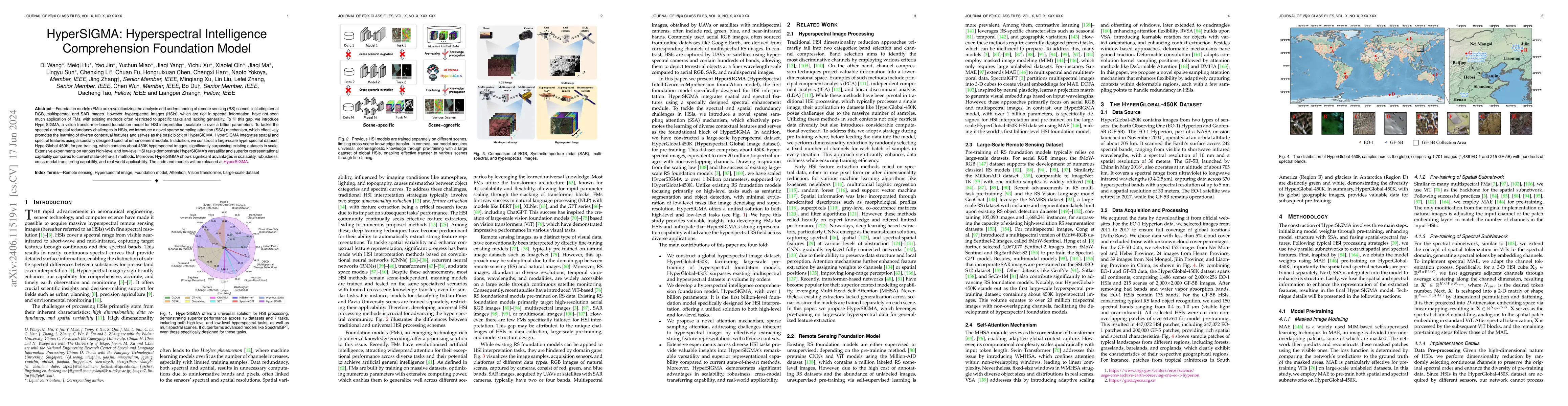
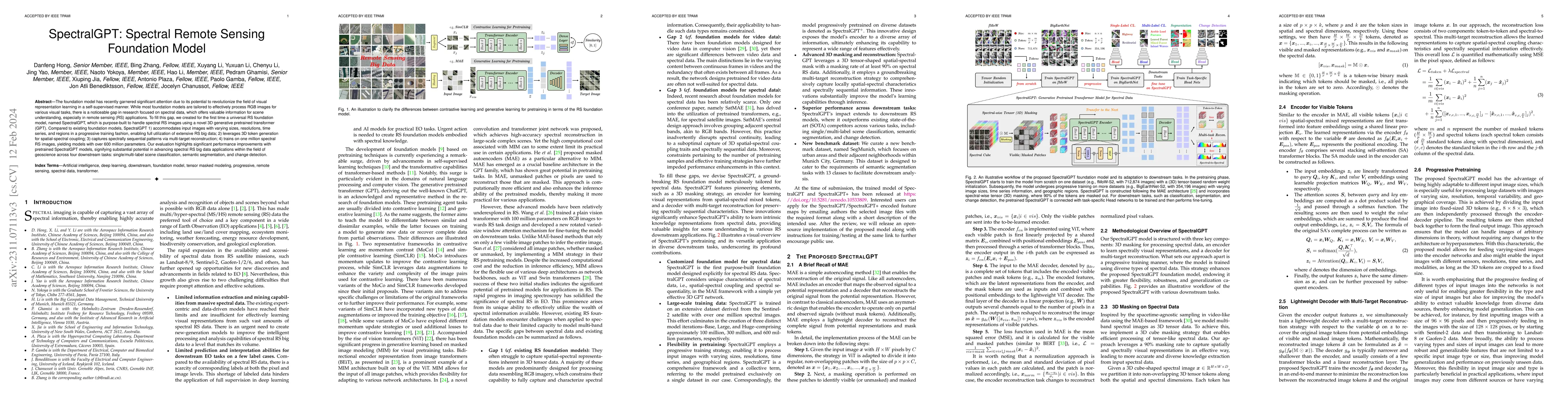
Foundation models (FMs) are revolutionizing the analysis and understanding of remote sensing (RS) scenes, including aerial RGB, multispectral, and SAR images. However, hyperspectral images (HSIs), whi...
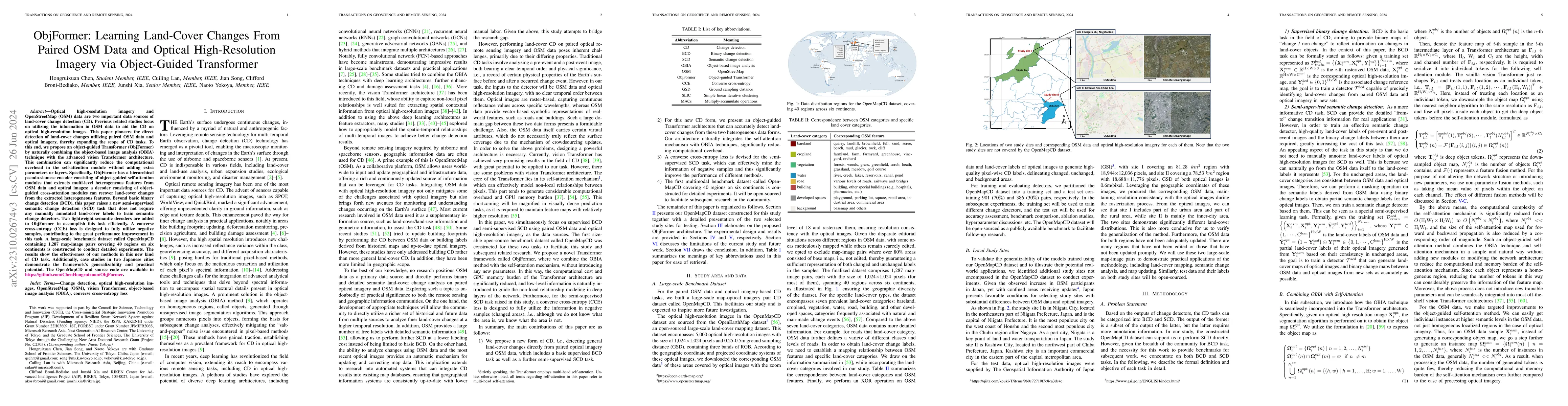
Optical high-resolution imagery and OSM data are two important data sources of change detection (CD). Previous related studies focus on utilizing the information in OSM data to aid the CD on optical h...
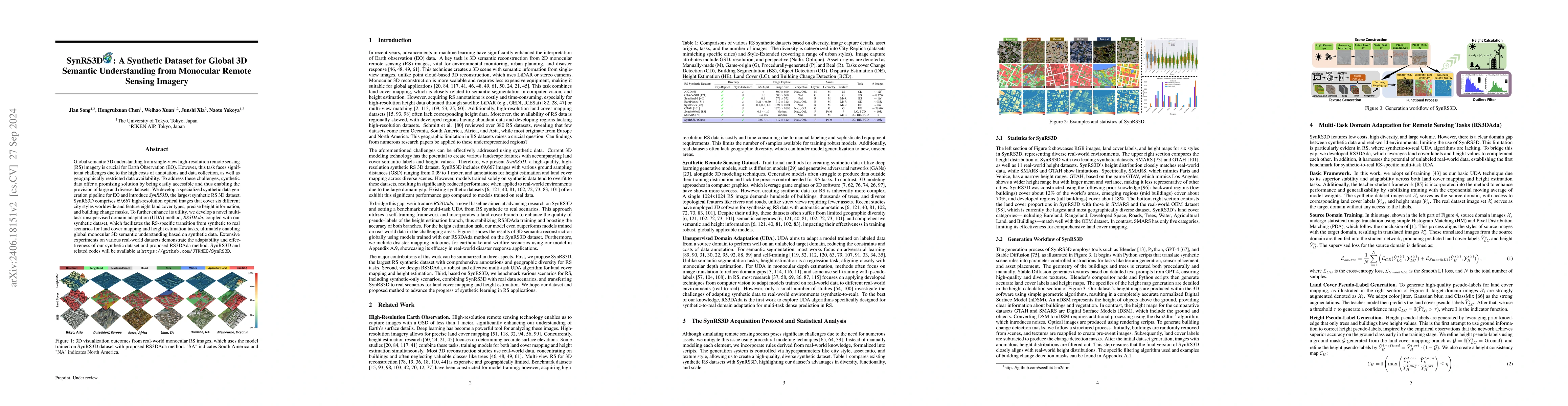
Global semantic 3D understanding from single-view high-resolution remote sensing (RS) imagery is crucial for Earth Observation (EO). However, this task faces significant challenges due to the high cos...
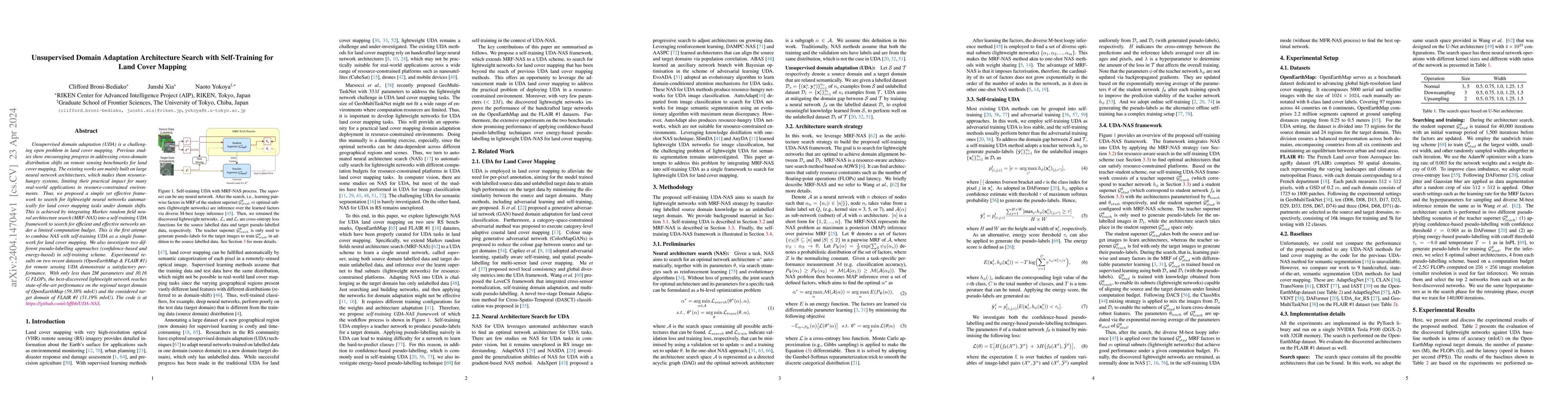
Unsupervised domain adaptation (UDA) is a challenging open problem in land cover mapping. Previous studies show encouraging progress in addressing cross-domain distribution shifts on remote sensing ...
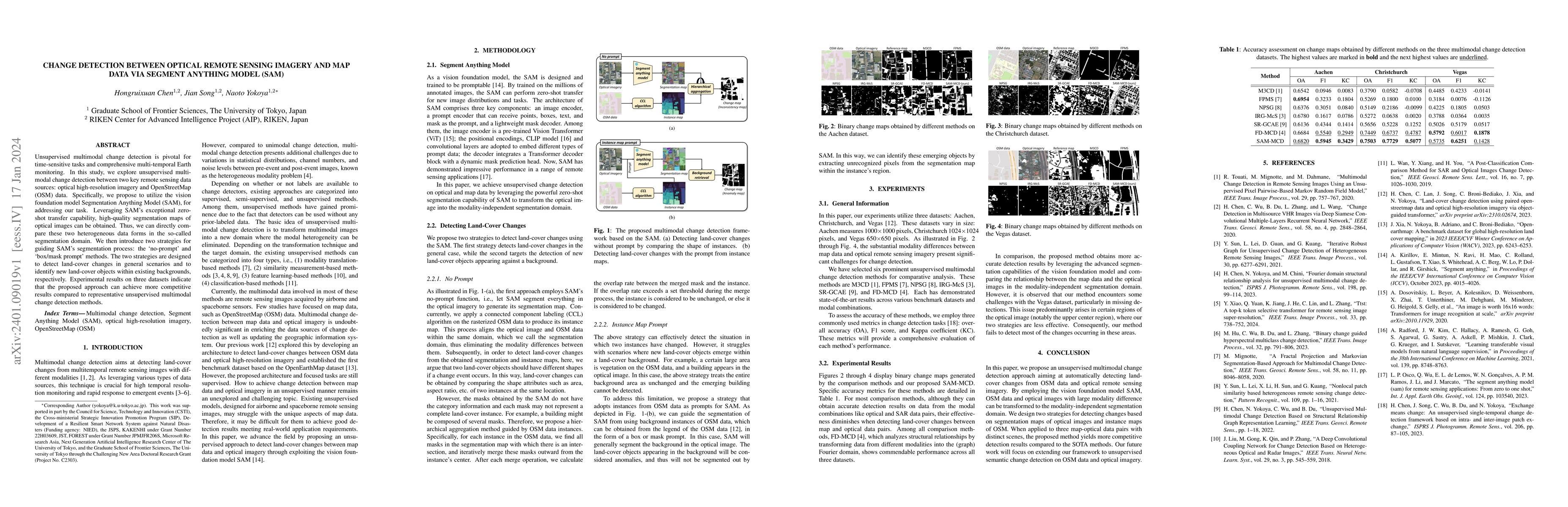
Unsupervised multimodal change detection is pivotal for time-sensitive tasks and comprehensive multi-temporal Earth monitoring. In this study, we explore unsupervised multimodal change detection bet...
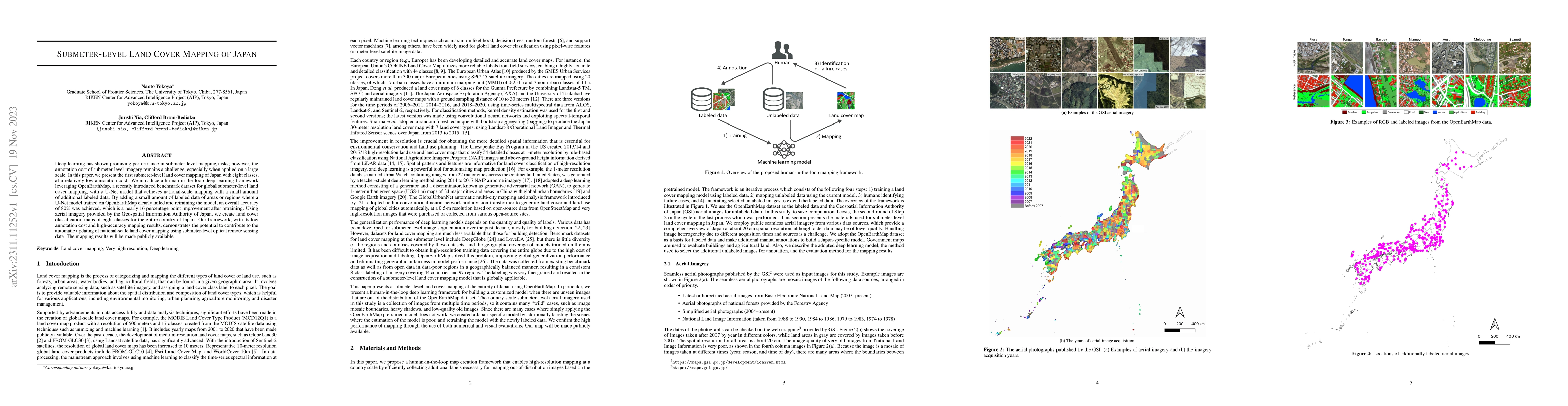
Deep learning has shown promising performance in submeter-level mapping tasks; however, the annotation cost of submeter-level imagery remains a challenge, especially when applied on a large scale. I...
The foundation model has recently garnered significant attention due to its potential to revolutionize the field of visual representation learning in a self-supervised manner. While most foundation ...
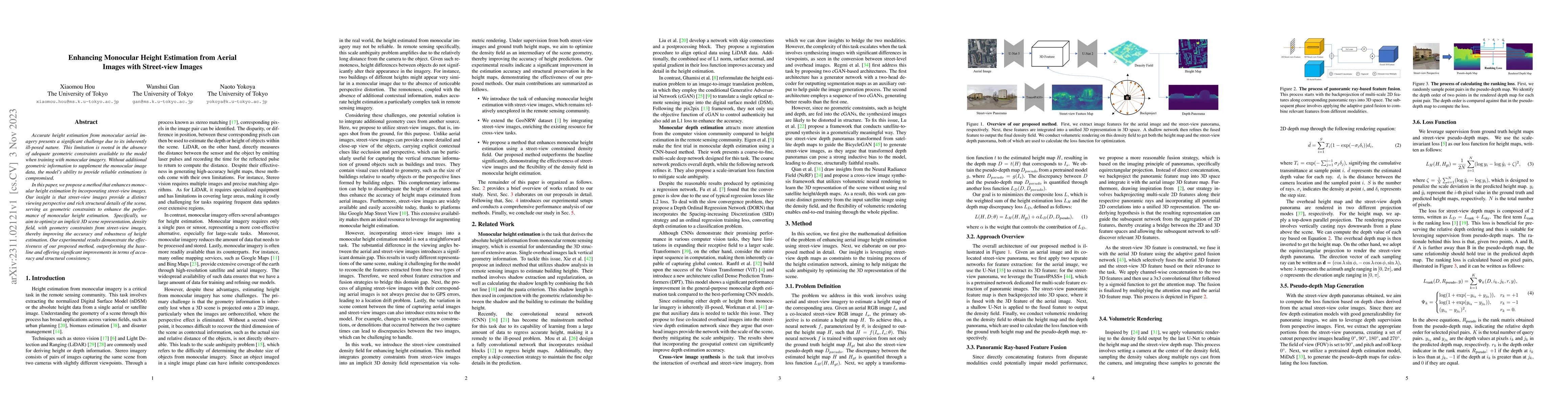
Accurate height estimation from monocular aerial imagery presents a significant challenge due to its inherently ill-posed nature. This limitation is rooted in the absence of adequate geometric const...
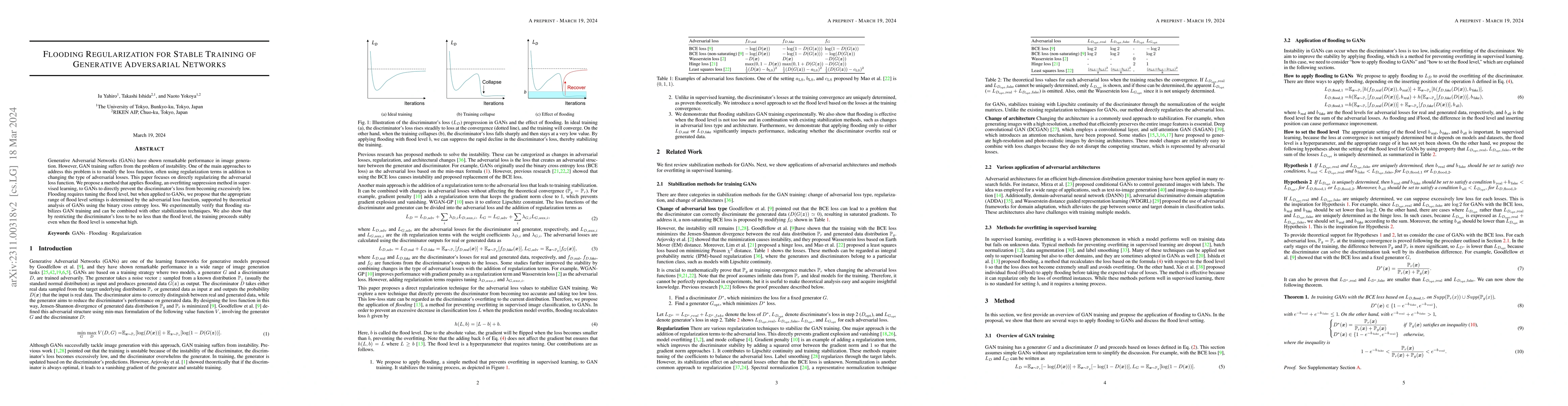
Generative Adversarial Networks (GANs) have shown remarkable performance in image generation. However, GAN training suffers from the problem of instability. One of the main approaches to address thi...
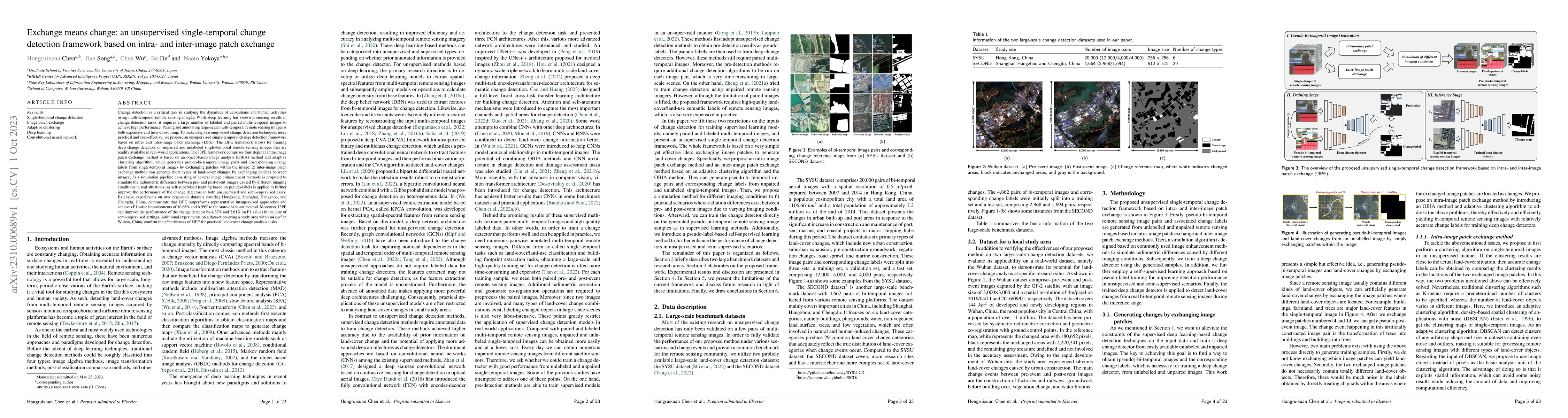
Change detection (CD) is a critical task in studying the dynamics of ecosystems and human activities using multi-temporal remote sensing images. While deep learning has shown promising results in CD...
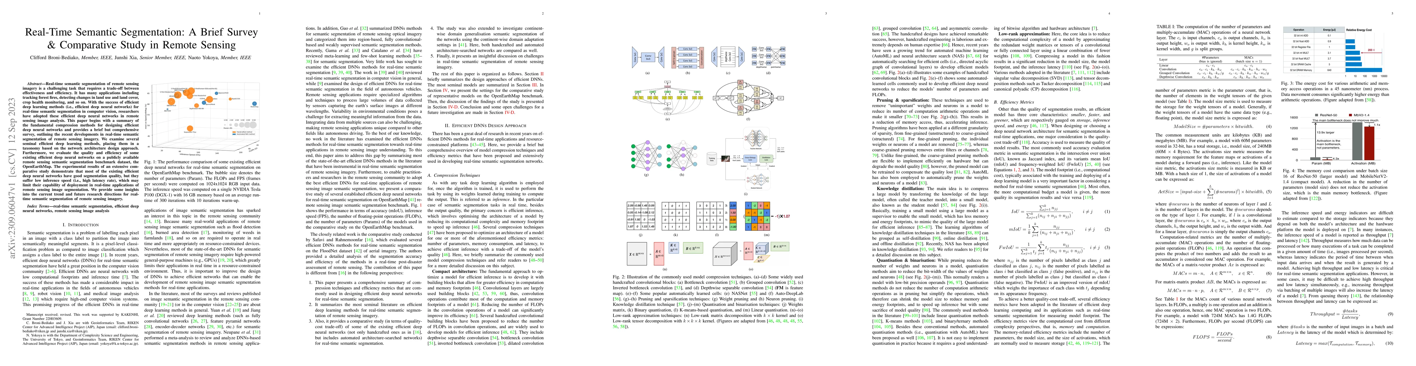
Real-time semantic segmentation of remote sensing imagery is a challenging task that requires a trade-off between effectiveness and efficiency. It has many applications including tracking forest fir...
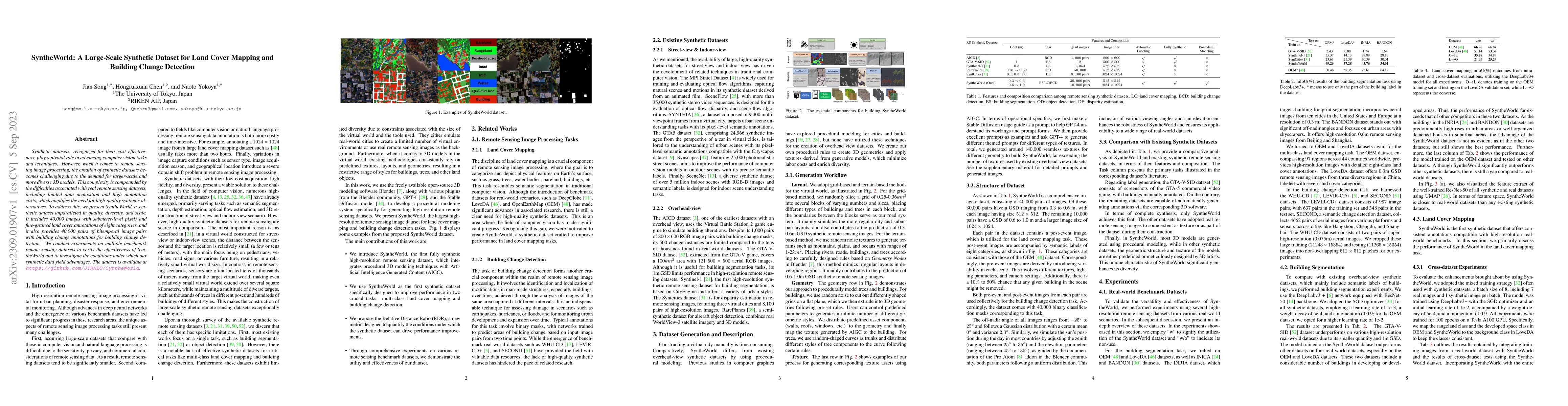
Synthetic datasets, recognized for their cost effectiveness, play a pivotal role in advancing computer vision tasks and techniques. However, when it comes to remote sensing image processing, the cre...
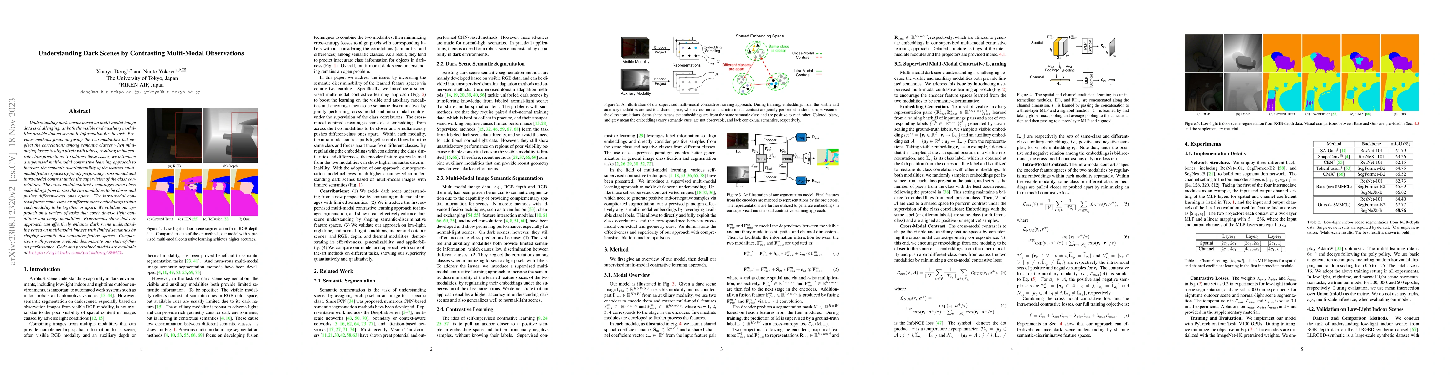
Understanding dark scenes based on multi-modal image data is challenging, as both the visible and auxiliary modalities provide limited semantic information for the task. Previous methods focus on fu...
The task of estimating 3D occupancy from surrounding-view images is an exciting development in the field of autonomous driving, following the success of Bird's Eye View (BEV) perception. This task p...
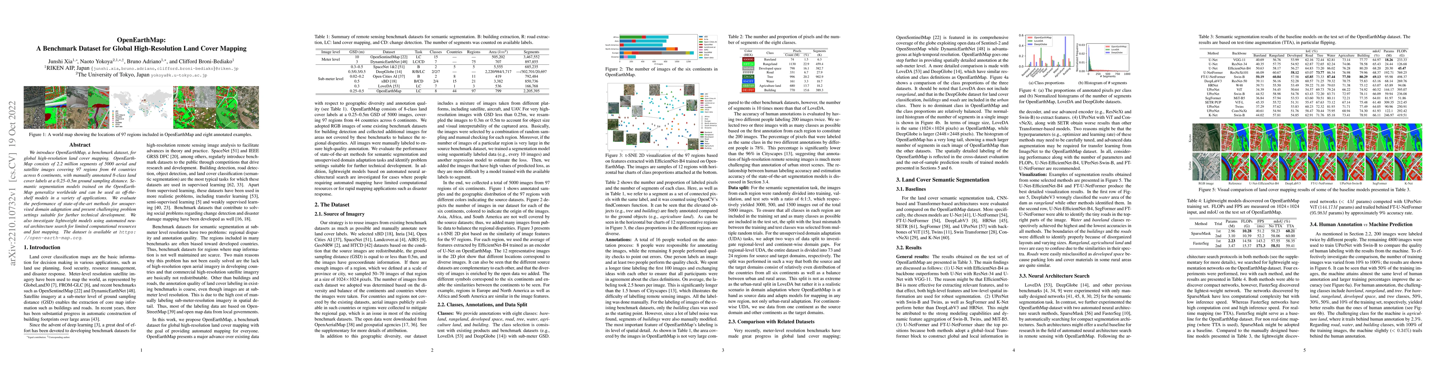
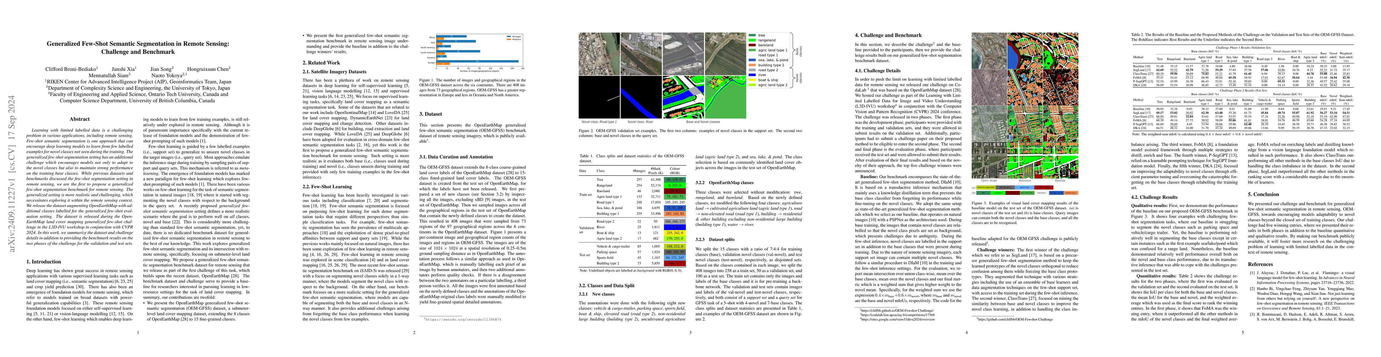
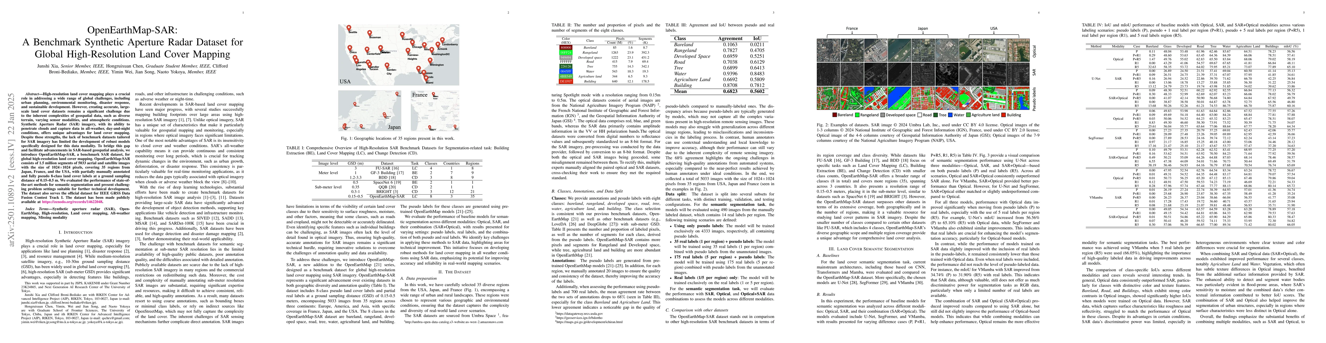
We introduce OpenEarthMap, a benchmark dataset, for global high-resolution land cover mapping. OpenEarthMap consists of 2.2 million segments of 5000 aerial and satellite images covering 97 regions f...
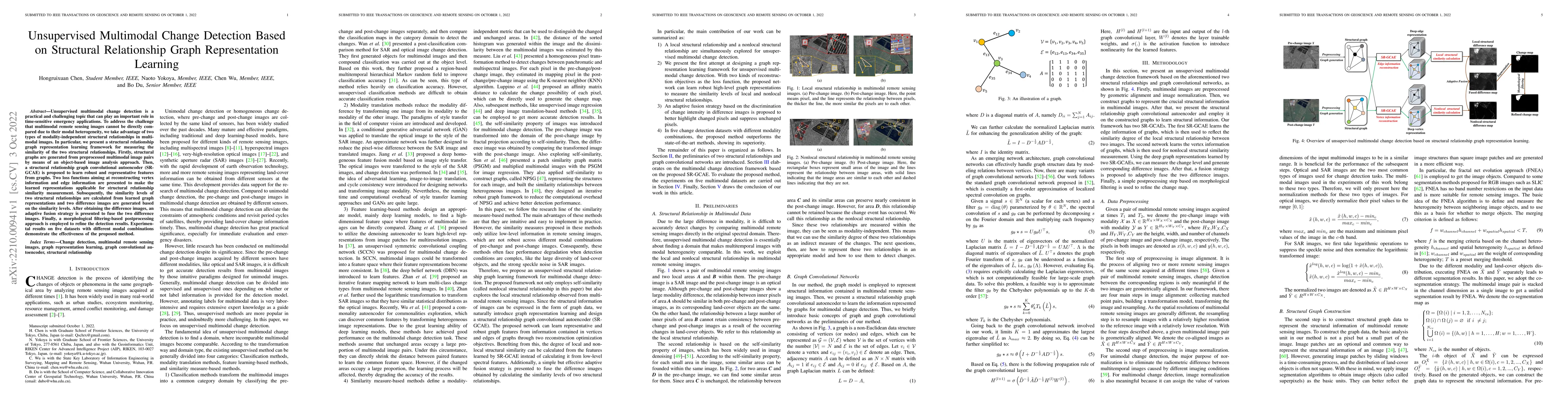
Unsupervised multimodal change detection is a practical and challenging topic that can play an important role in time-sensitive emergency applications. To address the challenge that multimodal remot...
In the era of deep learning, annotated datasets have become a crucial asset to the remote sensing community. In the last decade, a plethora of different datasets was published, each designed for a s...
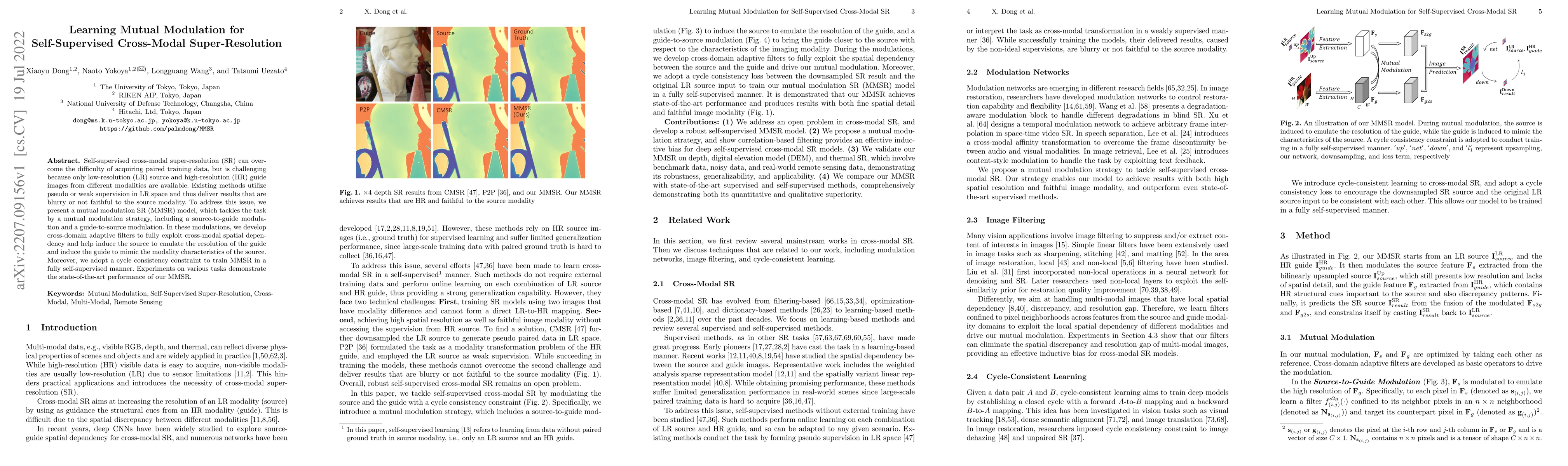
Self-supervised cross-modal super-resolution (SR) can overcome the difficulty of acquiring paired training data, but is challenging because only low-resolution (LR) source and high-resolution (HR) g...
Enormous efforts have been recently made to super-resolve hyperspectral (HS) images with the aid of high spatial resolution multispectral (MS) images. Most prior works usually perform the fusion tas...
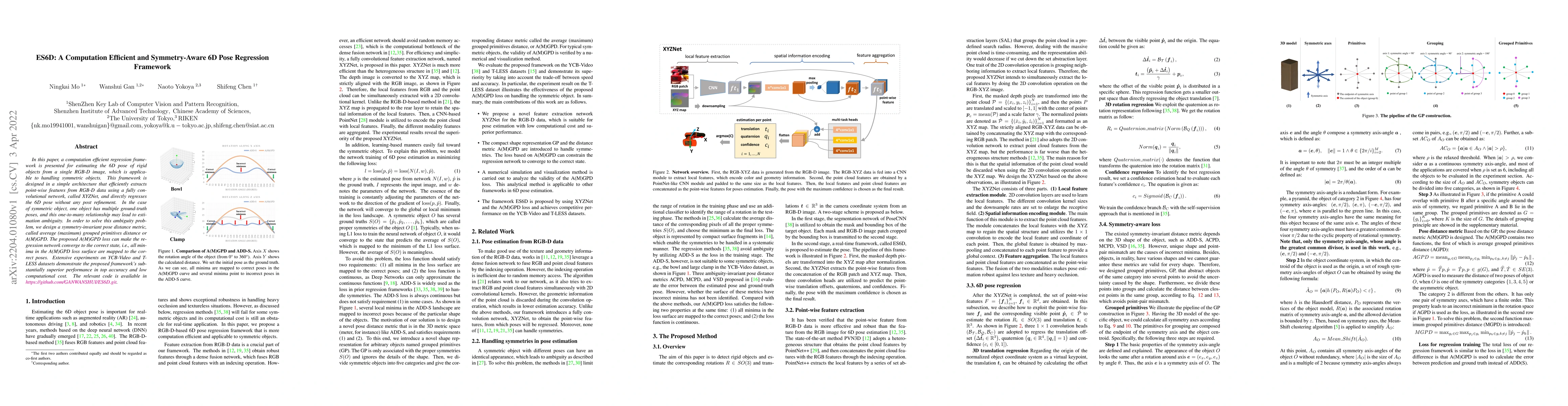
In this paper, a computation efficient regression framework is presented for estimating the 6D pose of rigid objects from a single RGB-D image, which is applicable to handling symmetric objects. Thi...
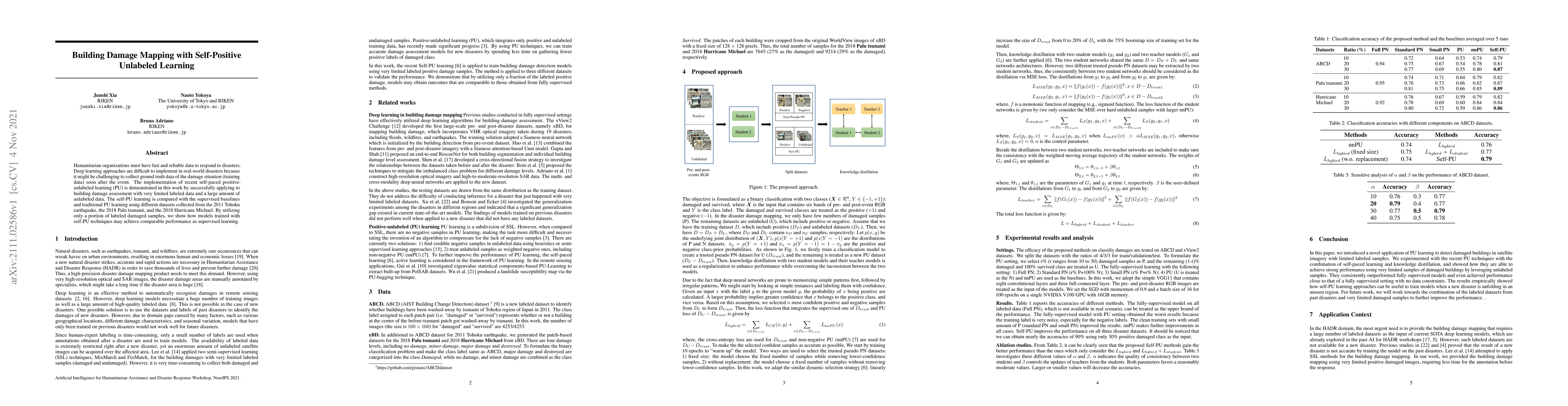
Humanitarian organizations must have fast and reliable data to respond to disasters. Deep learning approaches are difficult to implement in real-world disasters because it might be challenging to co...
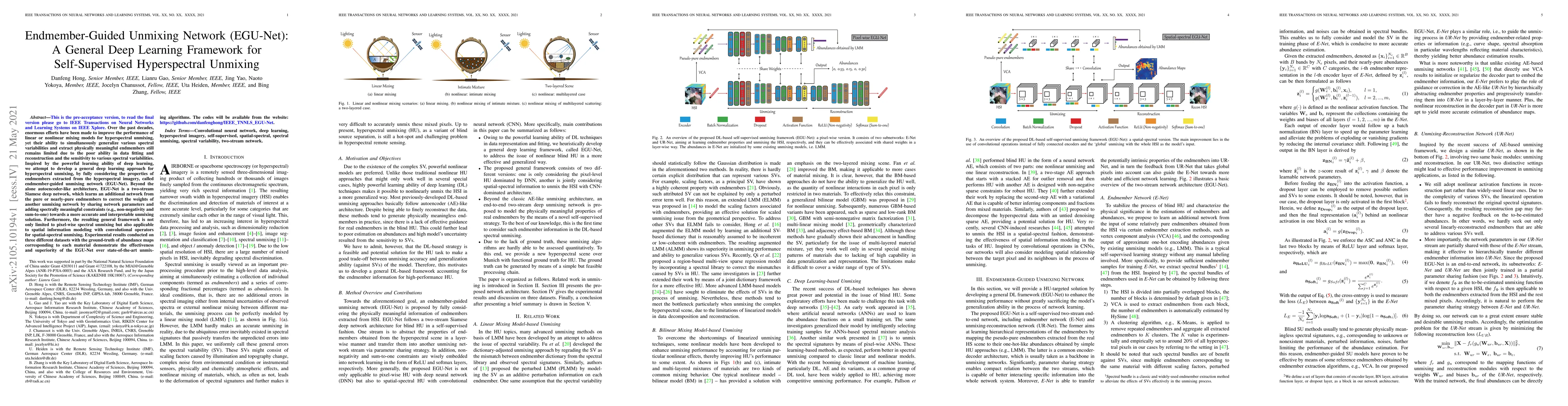
Over the past decades, enormous efforts have been made to improve the performance of linear or nonlinear mixing models for hyperspectral unmixing, yet their ability to simultaneously generalize vari...
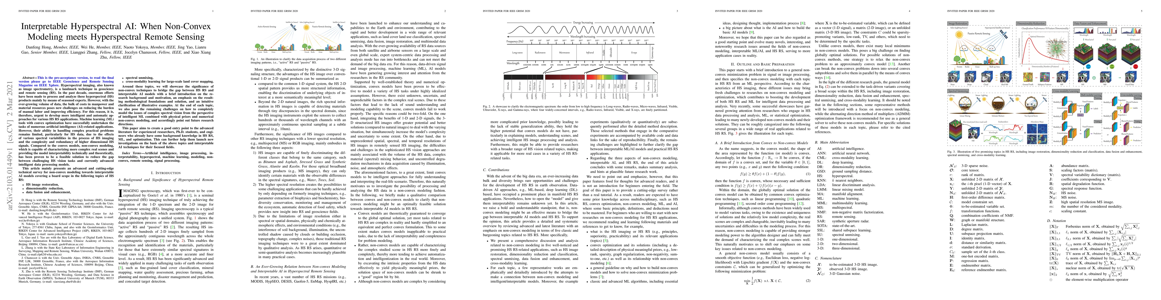
Hyperspectral imaging, also known as image spectrometry, is a landmark technique in geoscience and remote sensing (RS). In the past decade, enormous efforts have been made to process and analyze the...
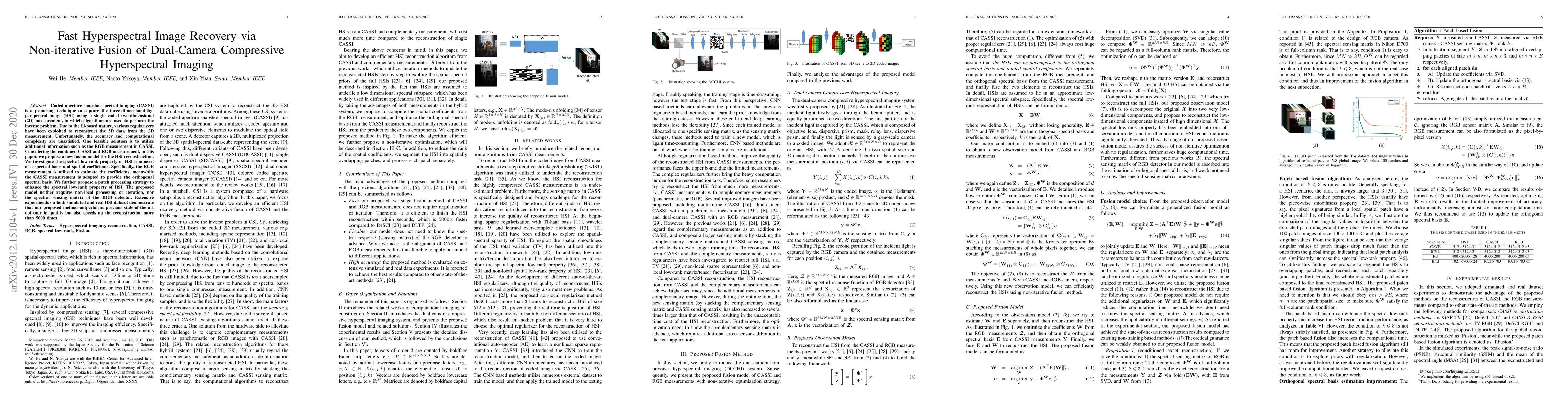
Coded aperture snapshot spectral imaging (CASSI) is a promising technique to capture the three-dimensional hyperspectral image (HSI) using a single coded two-dimensional (2D) measurement, in which a...
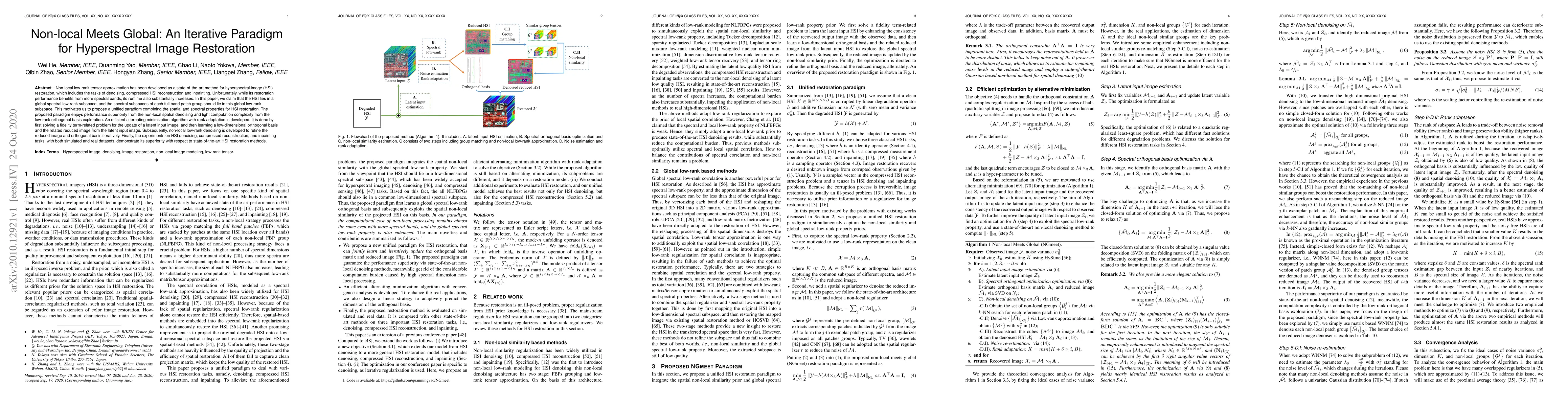
Non-local low-rank tensor approximation has been developed as a state-of-the-art method for hyperspectral image (HSI) restoration, which includes the tasks of denoising, compressed HSI reconstructio...
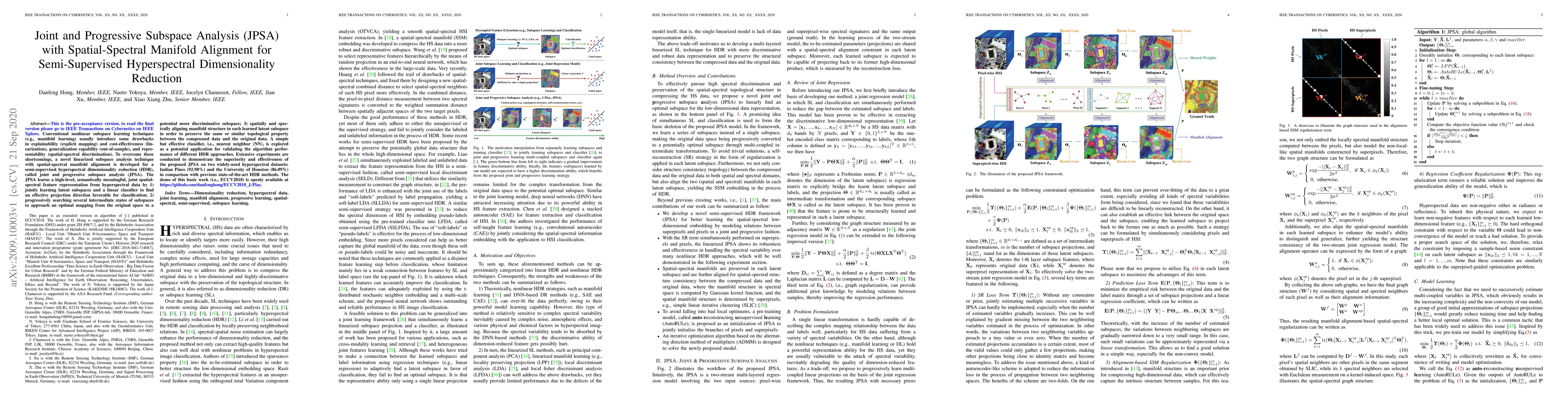
Conventional nonlinear subspace learning techniques (e.g., manifold learning) usually introduce some drawbacks in explainability (explicit mapping) and cost-effectiveness (linearization), generaliza...
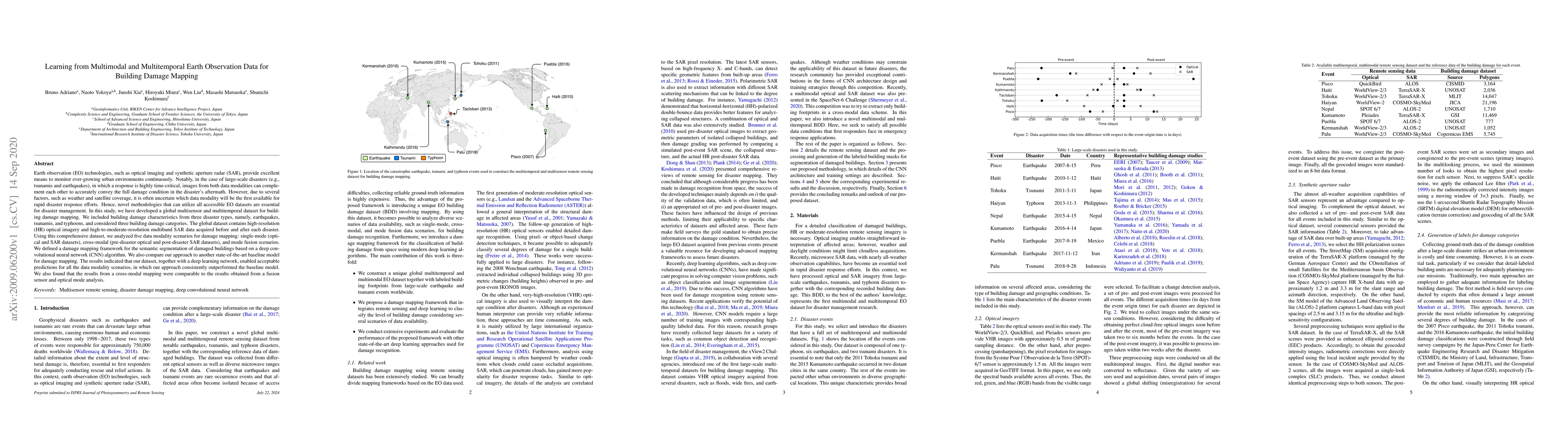
Earth observation technologies, such as optical imaging and synthetic aperture radar (SAR), provide excellent means to monitor ever-growing urban environments continuously. Notably, in the case of l...
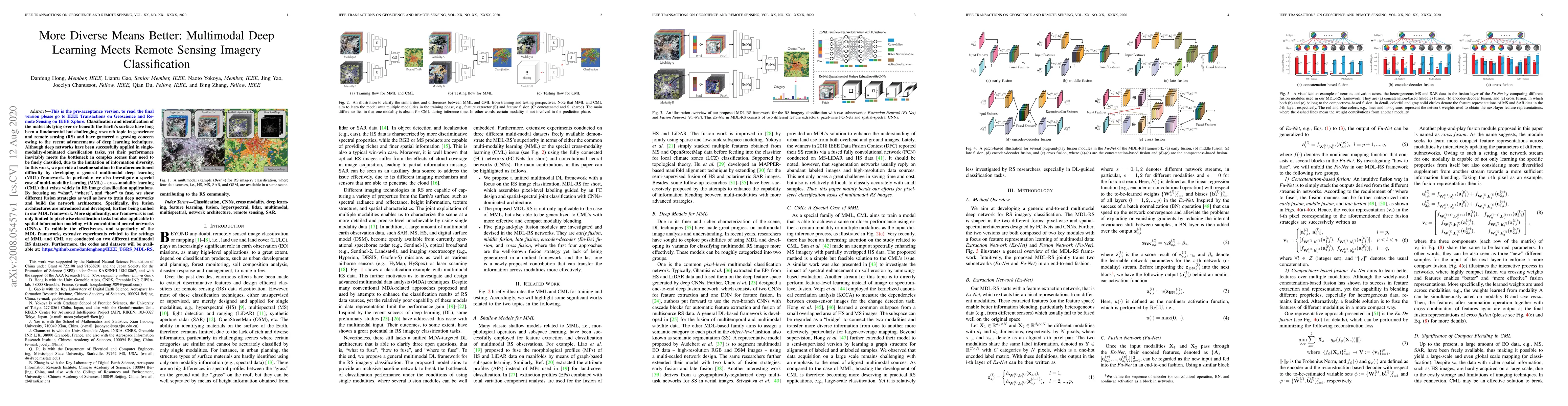
Classification and identification of the materials lying over or beneath the Earth's surface have long been a fundamental but challenging research topic in geoscience and remote sensing (RS) and hav...
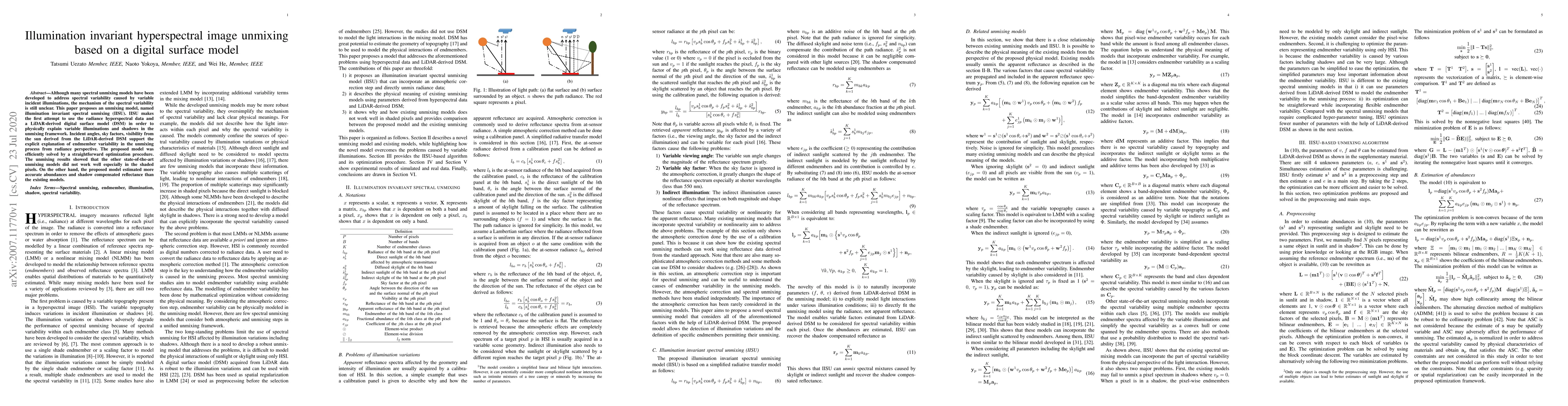
Although many spectral unmixing models have been developed to address spectral variability caused by variable incident illuminations, the mechanism of the spectral variability is still unclear. This...
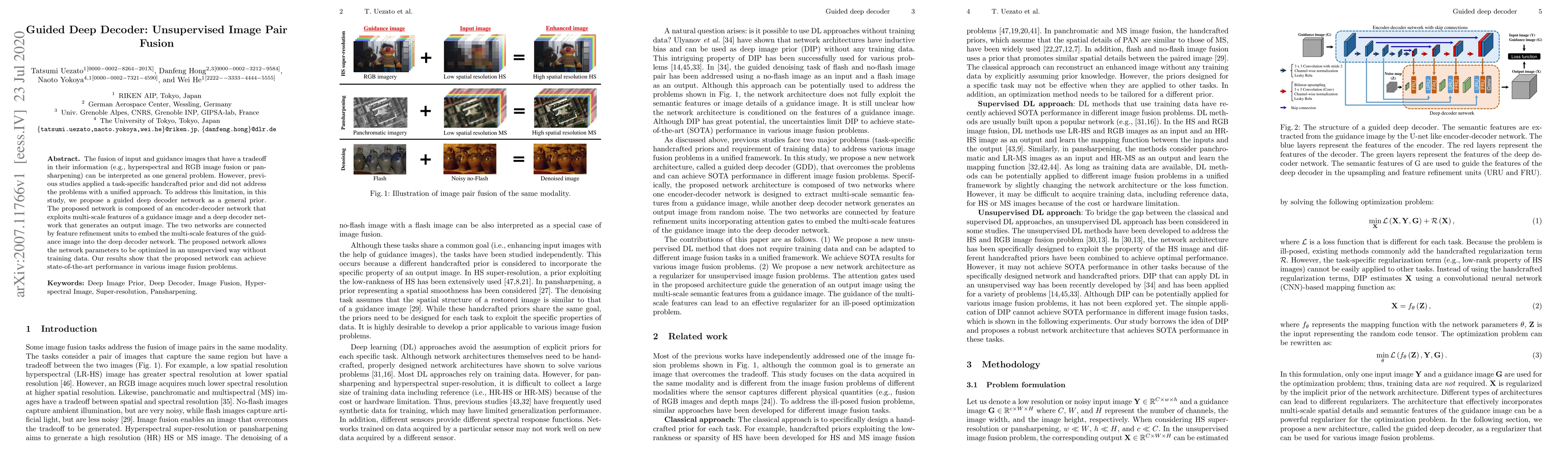
The fusion of input and guidance images that have a tradeoff in their information (e.g., hyperspectral and RGB image fusion or pansharpening) can be interpreted as one general problem. However, prev...
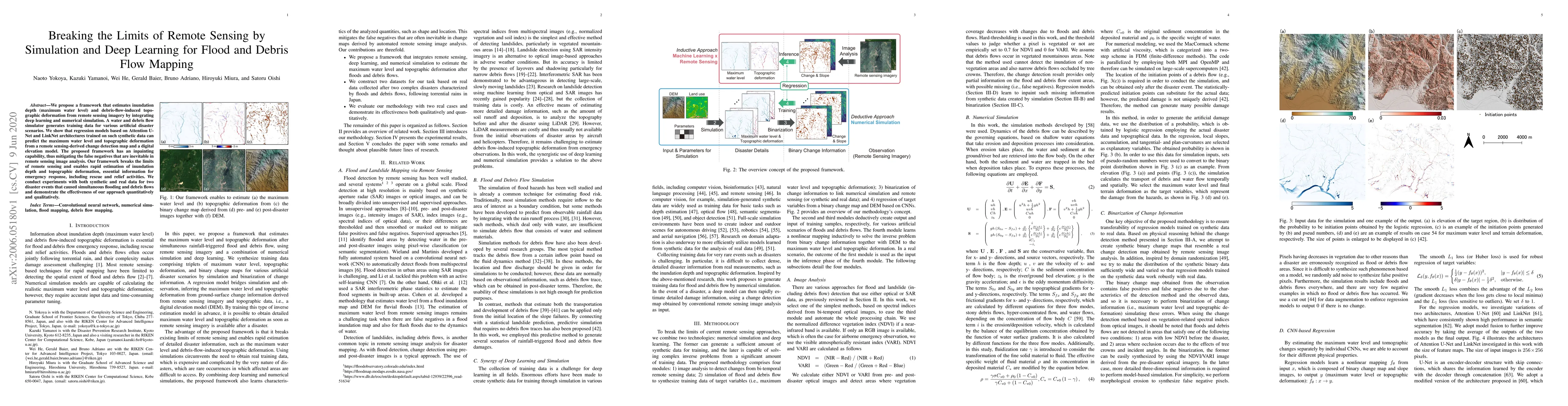
We propose a framework that estimates inundation depth (maximum water level) and debris-flow-induced topographic deformation from remote sensing imagery by integrating deep learning and numerical si...
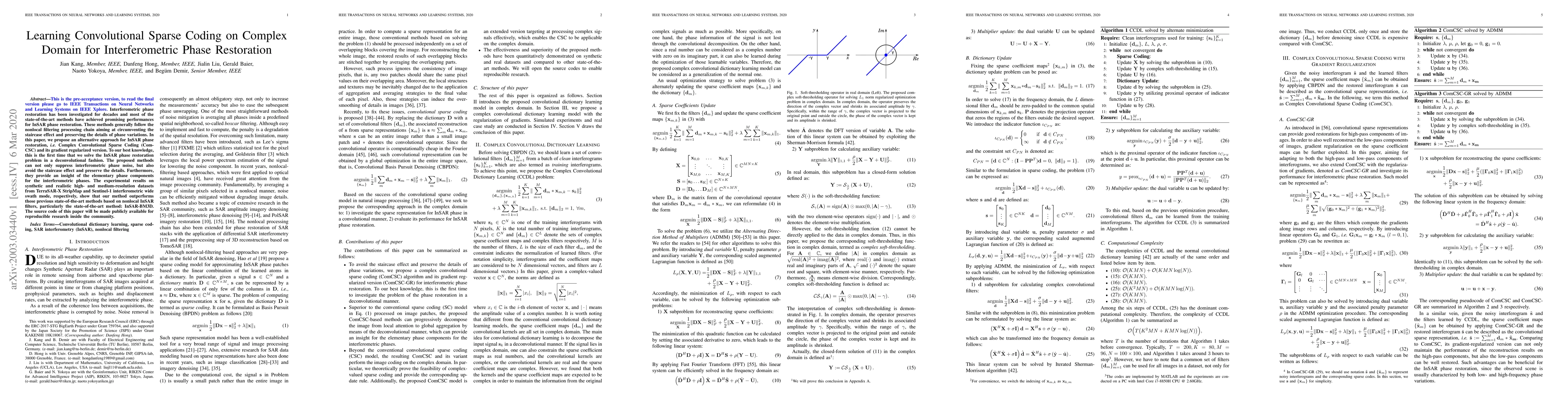
Interferometric phase restoration has been investigated for decades and most of the state-of-the-art methods have achieved promising performances for InSAR phase restoration. These methods generally...
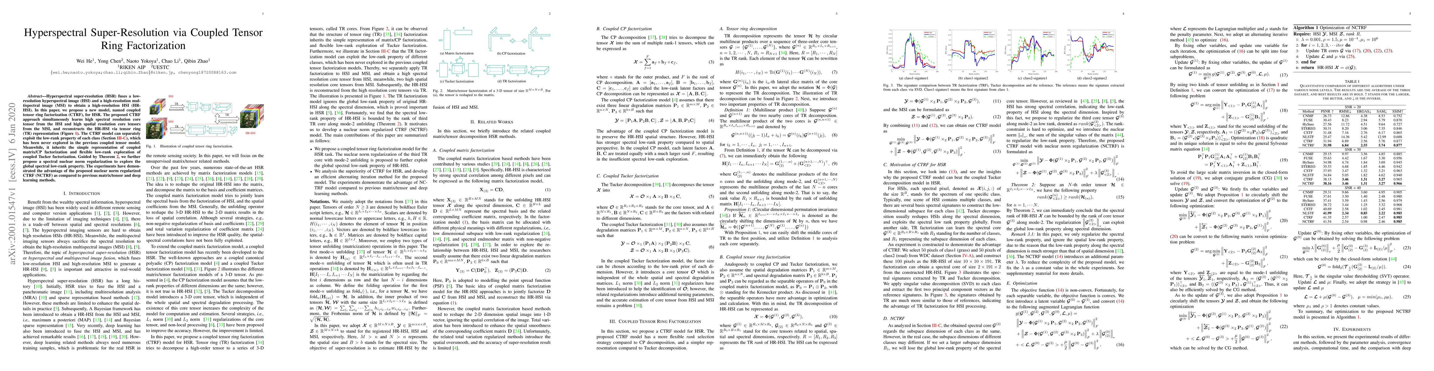
Hyperspectral super-resolution (HSR) fuses a low-resolution hyperspectral image (HSI) and a high-resolution multispectral image (MSI) to obtain a high-resolution HSI (HR-HSI). In this paper, we prop...
Up to the present, an enormous number of advanced techniques have been developed to enhance and extract the spatially semantic information in hyperspectral image processing and analysis. However, lo...
In this paper, we aim at tackling a general but interesting cross-modality feature learning question in remote sensing community --- can a limited amount of highly-discrimin-ative (e.g., hyperspectr...
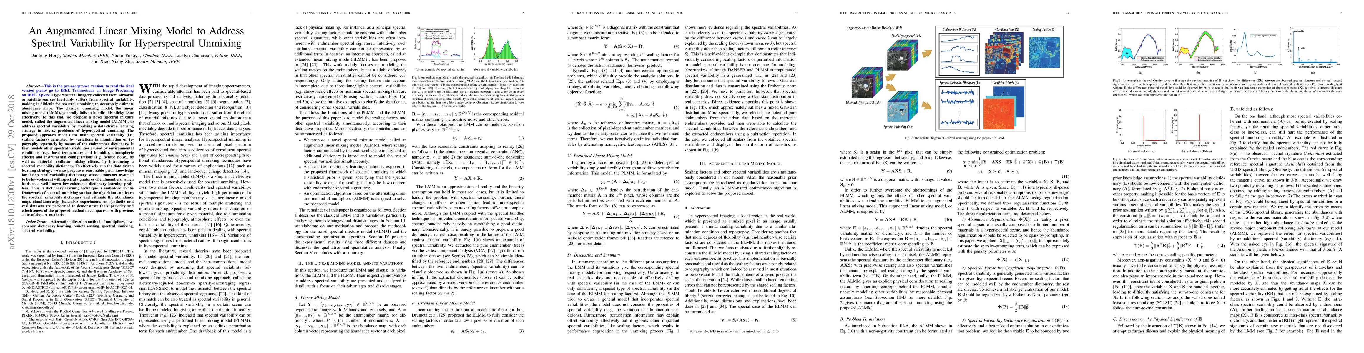
Hyperspectral imagery collected from airborne or satellite sources inevitably suffers from spectral variability, making it difficult for spectral unmixing to accurately estimate abundance maps. The ...
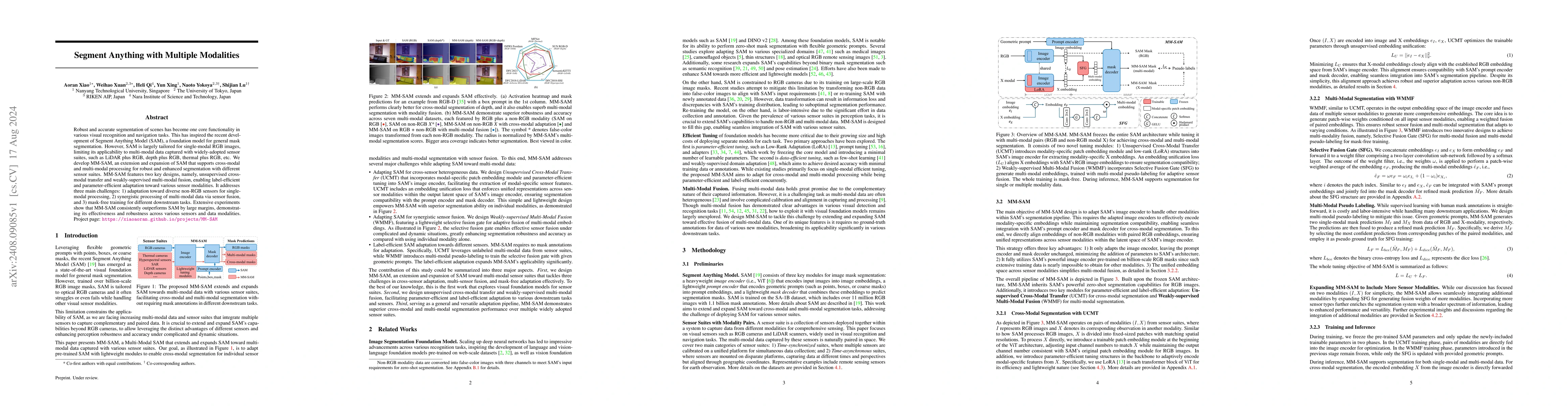
Robust and accurate segmentation of scenes has become one core functionality in various visual recognition and navigation tasks. This has inspired the recent development of Segment Anything Model (SAM...
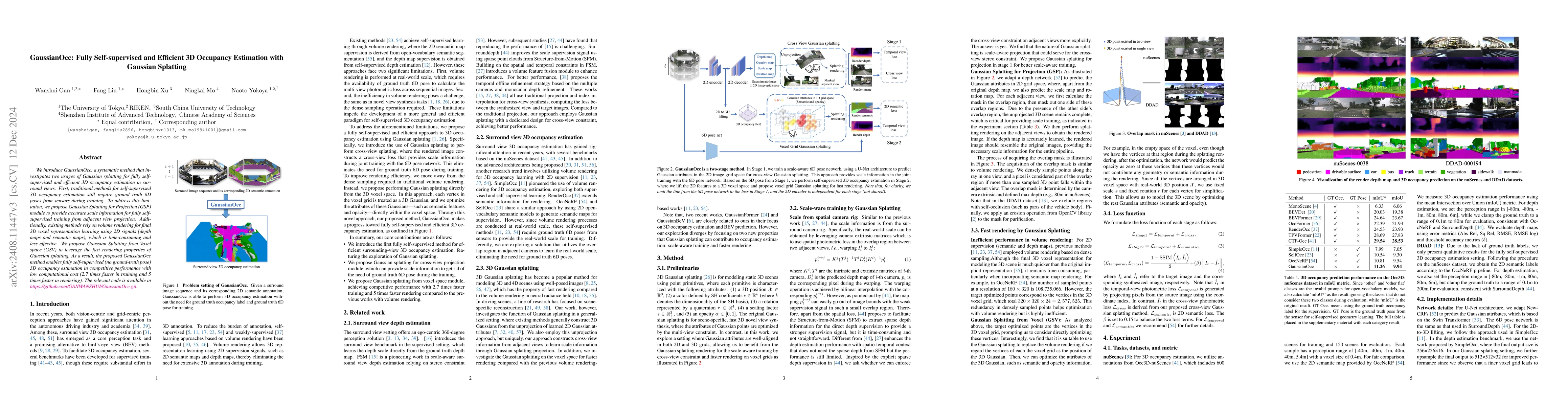
We introduce GaussianOcc, a systematic method that investigates the two usages of Gaussian splatting for fully self-supervised and efficient 3D occupancy estimation in surround views. First, tradition...
Learning with limited labelled data is a challenging problem in various applications, including remote sensing. Few-shot semantic segmentation is one approach that can encourage deep learning models t...
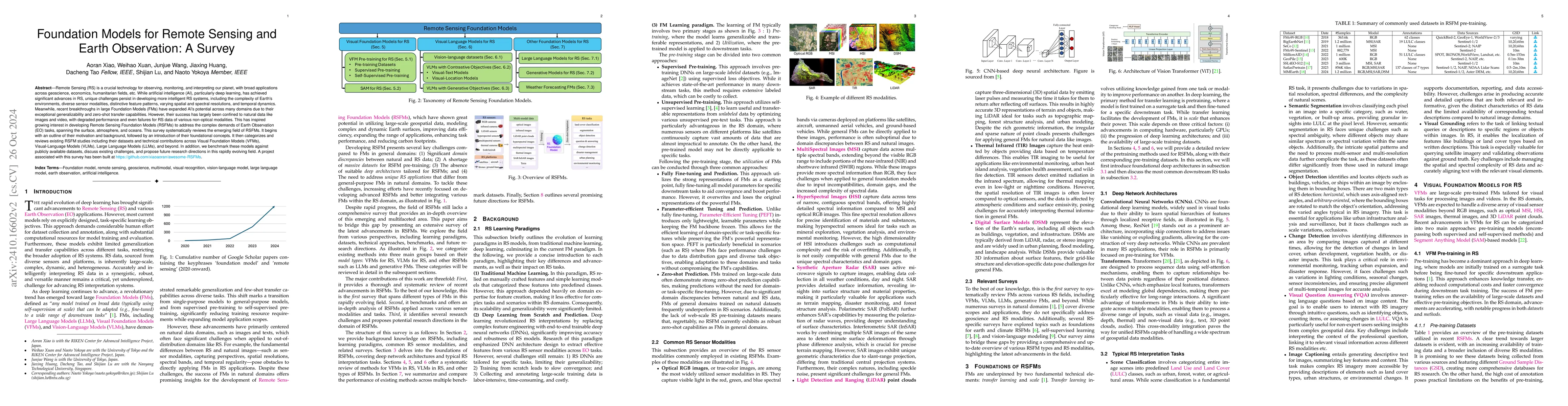
Remote Sensing (RS) is a crucial technology for observing, monitoring, and interpreting our planet, with broad applications across geoscience, economics, humanitarian fields, etc. While artificial int...
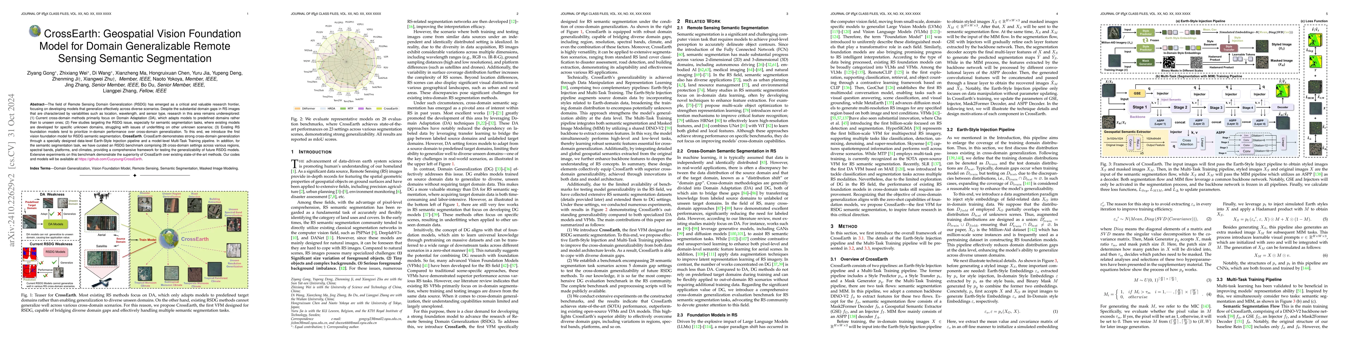
The field of Remote Sensing Domain Generalization (RSDG) has emerged as a critical and valuable research frontier, focusing on developing models that generalize effectively across diverse scenarios. D...
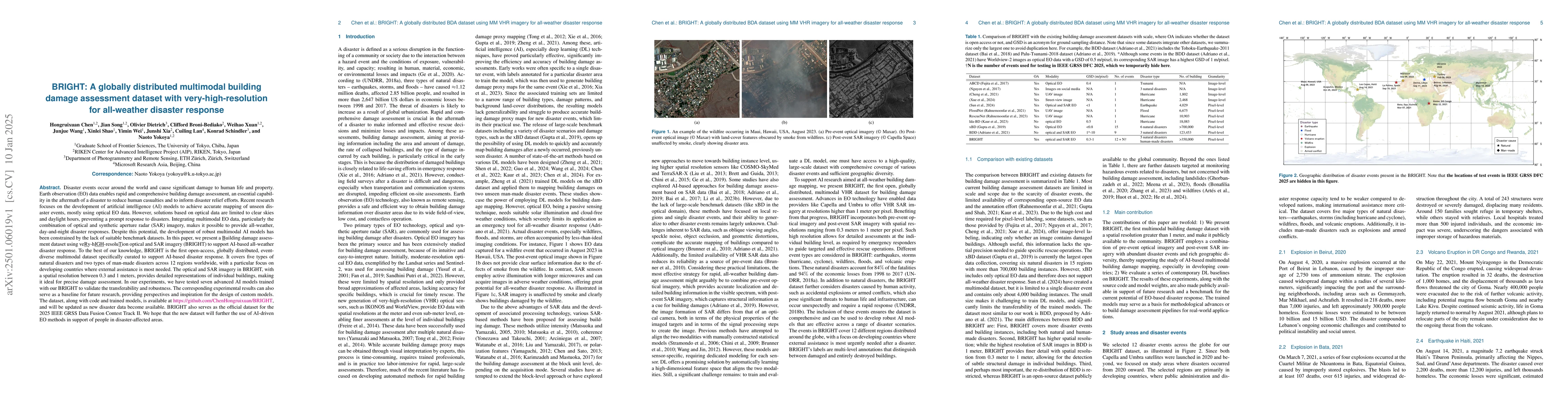
Disaster events occur around the world and cause significant damage to human life and property. Earth observation (EO) data enables rapid and comprehensive building damage assessment (BDA), an essenti...
High-resolution land cover mapping plays a crucial role in addressing a wide range of global challenges, including urban planning, environmental monitoring, disaster response, and sustainable developm...
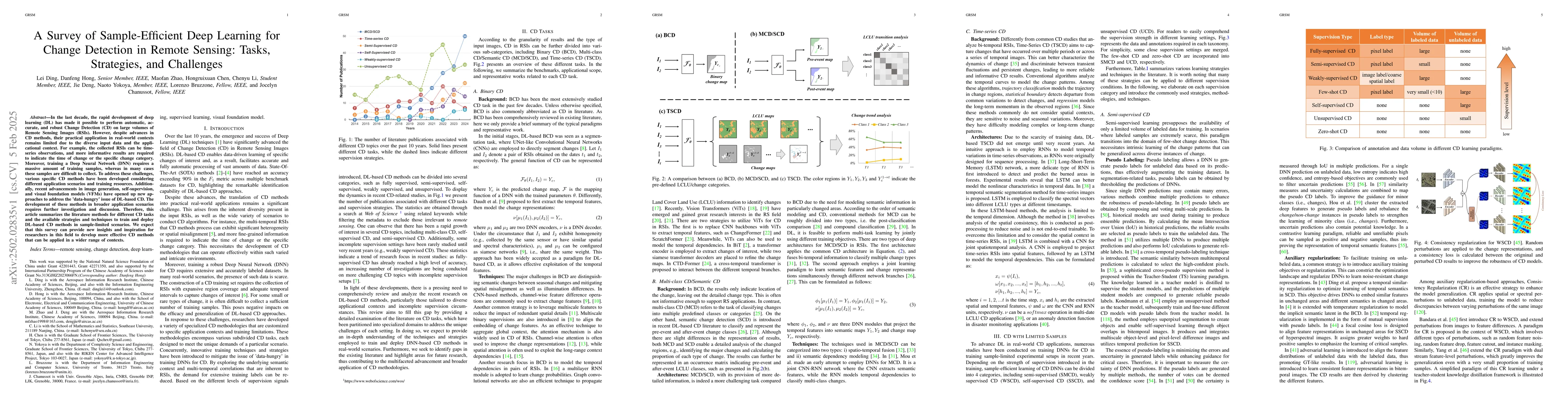
In the last decade, the rapid development of deep learning (DL) has made it possible to perform automatic, accurate, and robust Change Detection (CD) on large volumes of Remote Sensing Images (RSIs). ...
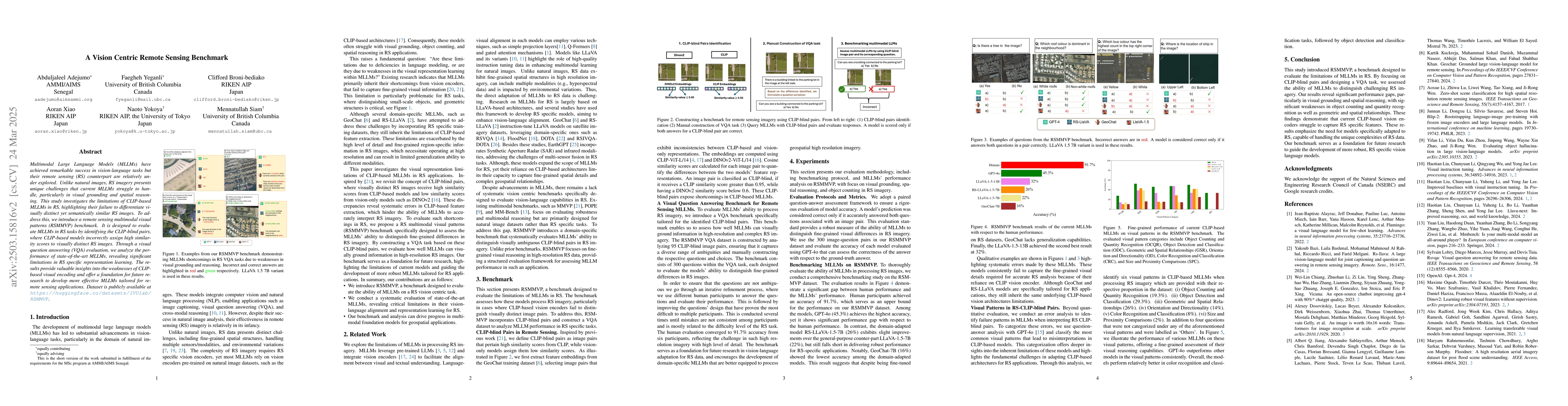
Multimodal Large Language Models (MLLMs) have achieved remarkable success in vision-language tasks but their remote sensing (RS) counterpart are relatively under explored. Unlike natural images, RS im...
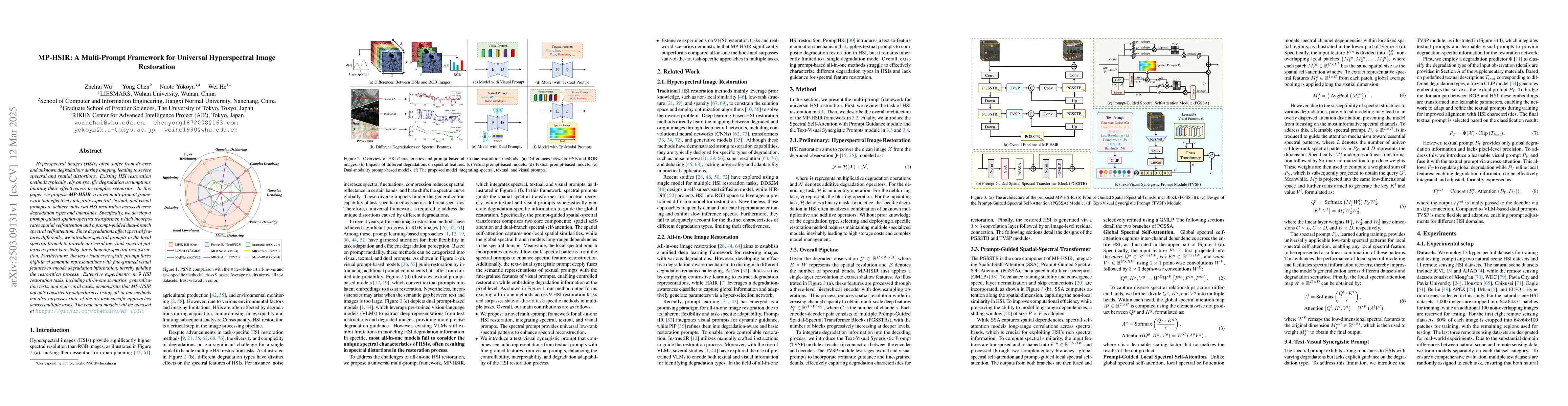
Hyperspectral images (HSIs) often suffer from diverse and unknown degradations during imaging, leading to severe spectral and spatial distortions. Existing HSI restoration methods typically rely on sp...
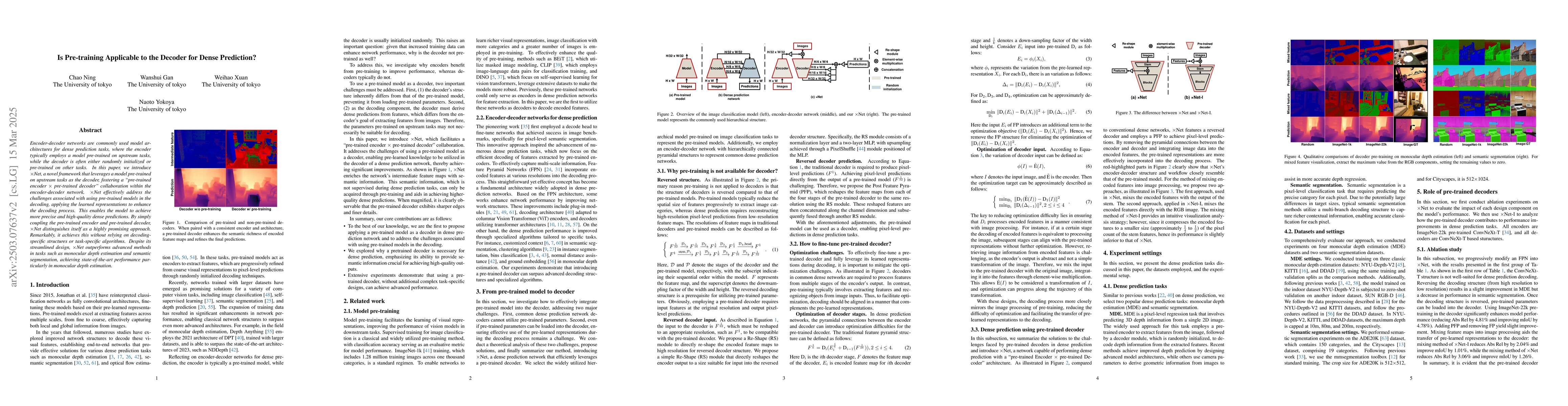
Pre-trained encoders are widely employed in dense prediction tasks for their capability to effectively extract visual features from images. The decoder subsequently processes these features to generat...
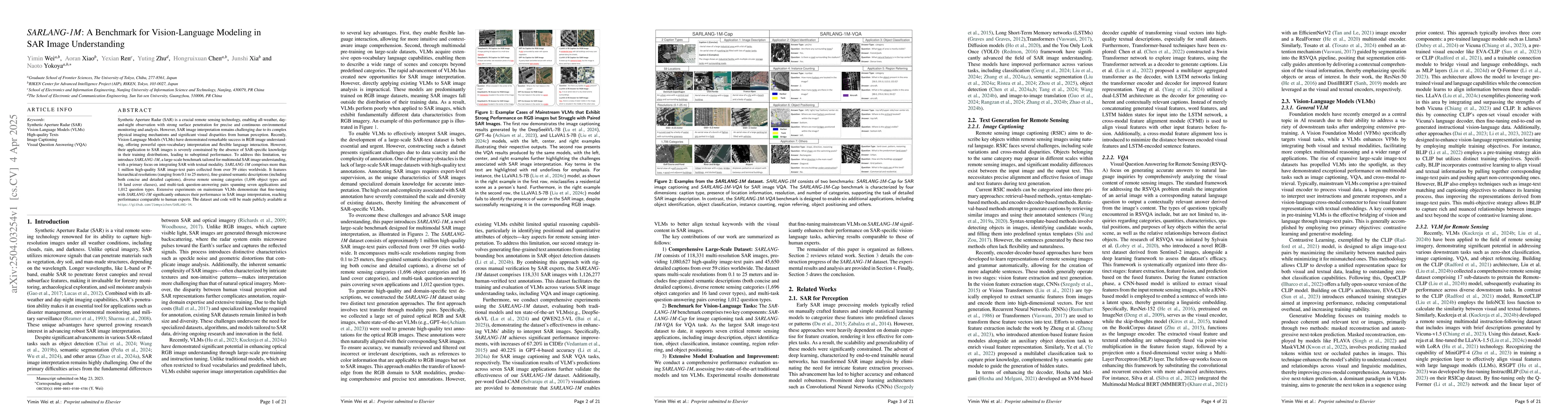
Synthetic Aperture Radar (SAR) is a crucial remote sensing technology, enabling all-weather, day-and-night observation with strong surface penetration for precise and continuous environmental monitori...
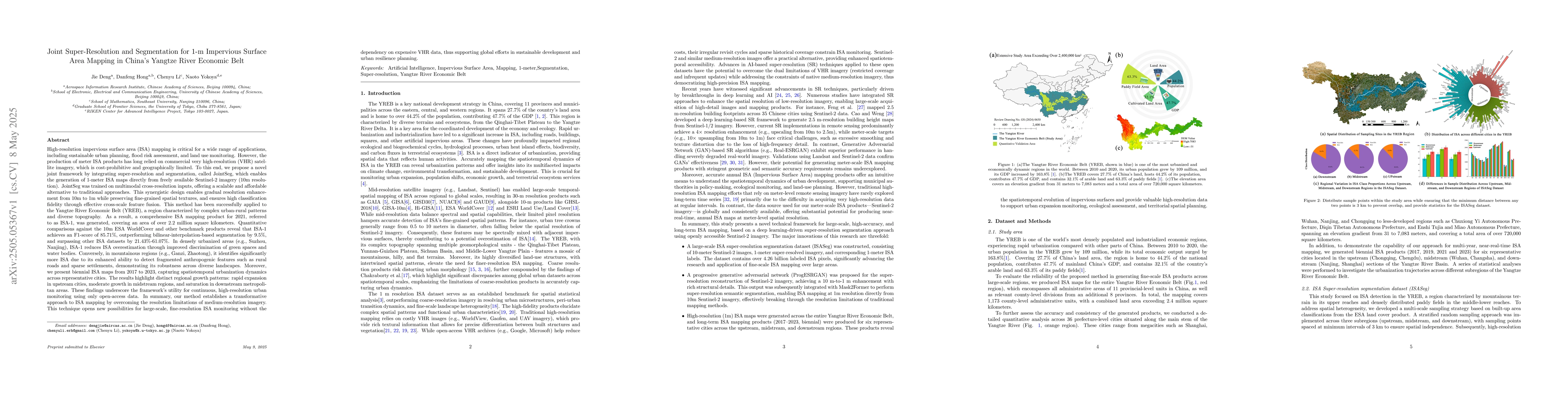
We propose a novel joint framework by integrating super-resolution and segmentation, called JointSeg, which enables the generation of 1-meter ISA maps directly from freely available Sentinel-2 imagery...
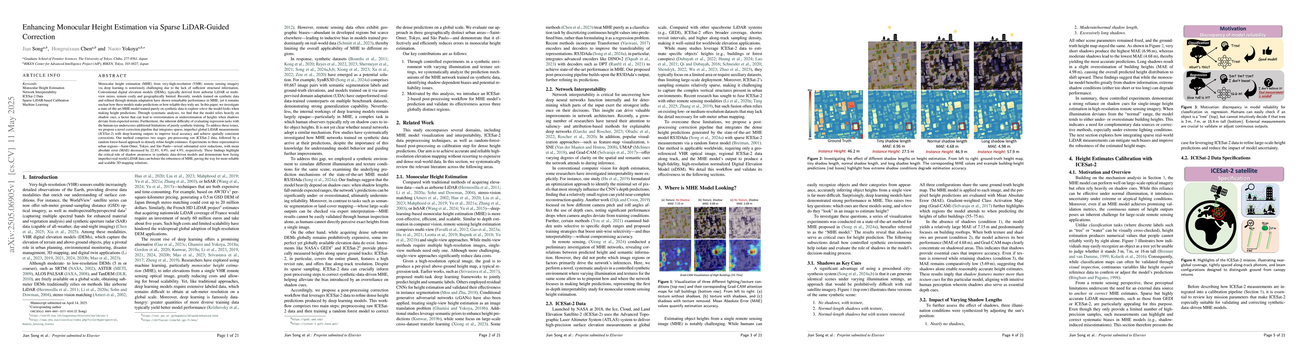
Monocular height estimation (MHE) from very-high-resolution (VHR) remote sensing imagery via deep learning is notoriously challenging due to the lack of sufficient structural information. Conventional...
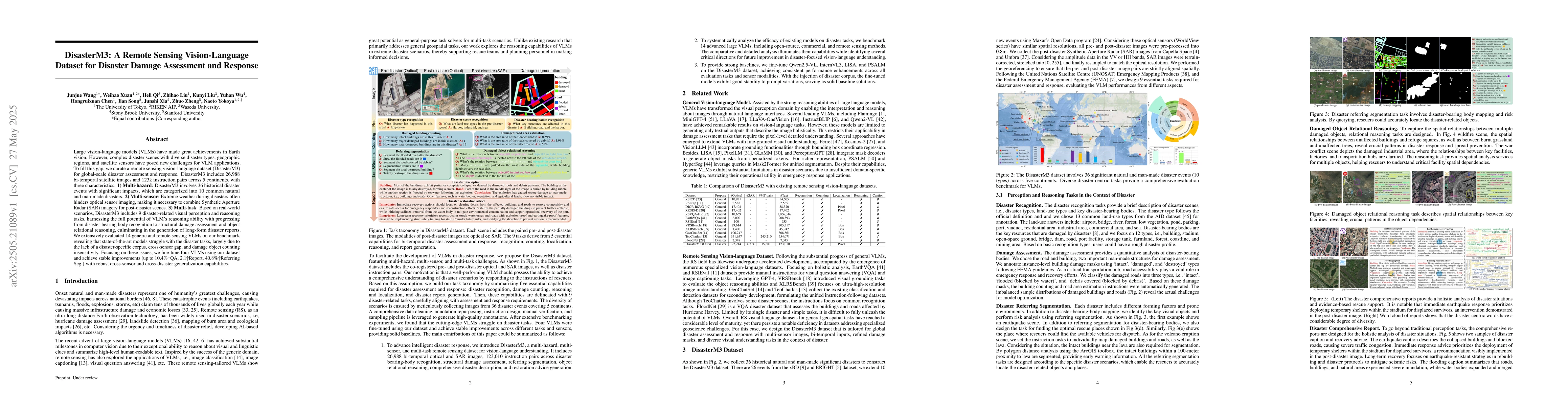
Large vision-language models (VLMs) have made great achievements in Earth vision. However, complex disaster scenes with diverse disaster types, geographic regions, and satellite sensors have posed new...
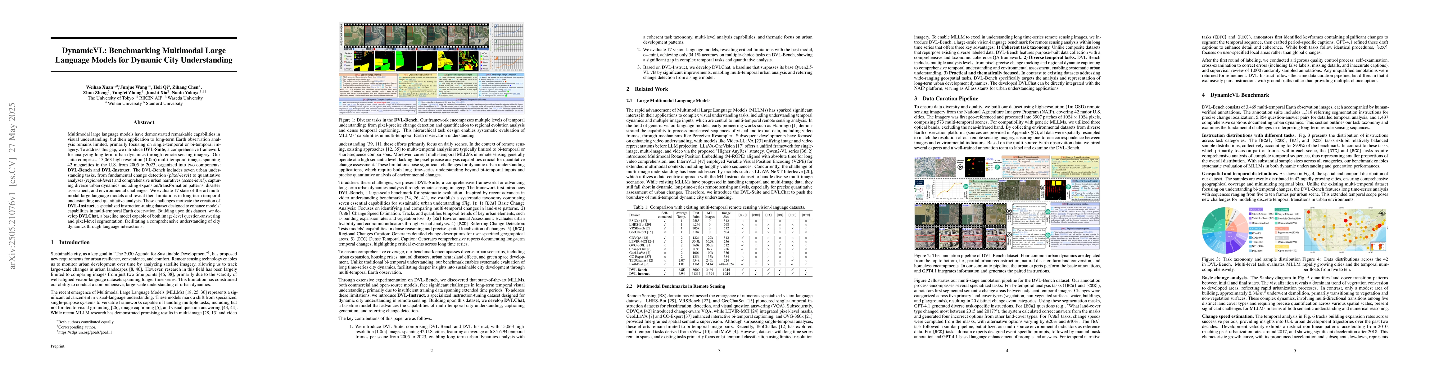
Multimodal large language models have demonstrated remarkable capabilities in visual understanding, but their application to long-term Earth observation analysis remains limited, primarily focusing on...
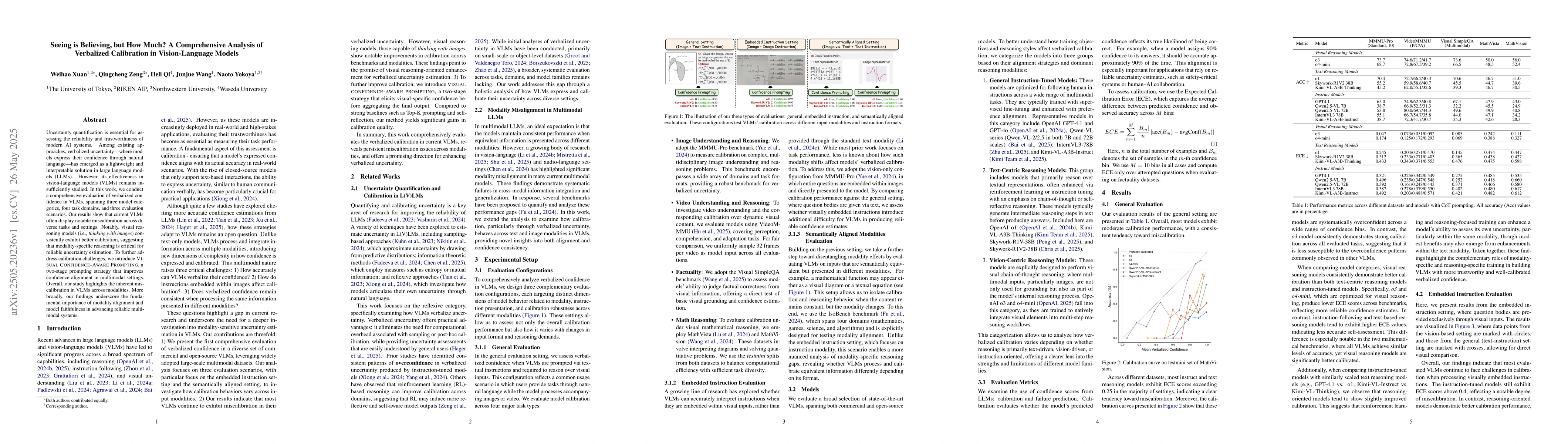
Uncertainty quantification is essential for assessing the reliability and trustworthiness of modern AI systems. Among existing approaches, verbalized uncertainty, where models express their confidence...
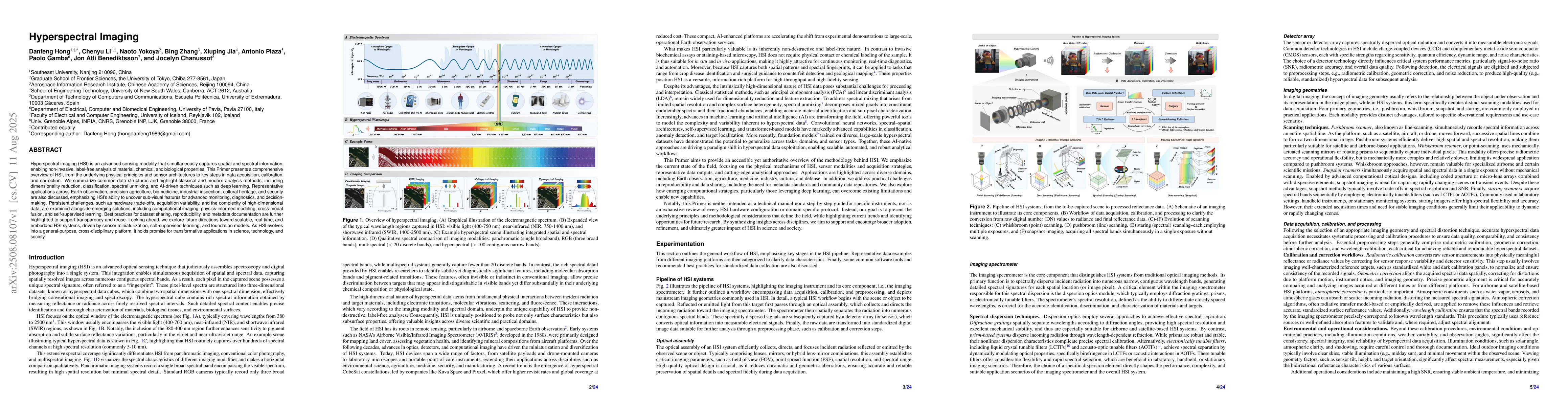
Hyperspectral imaging (HSI) is an advanced sensing modality that simultaneously captures spatial and spectral information, enabling non-invasive, label-free analysis of material, chemical, and biologi...
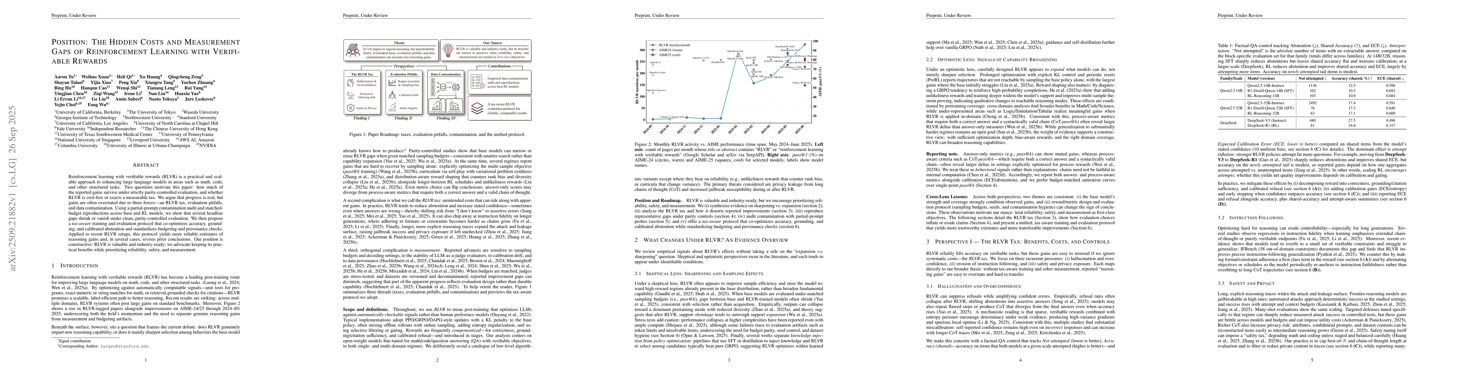
Reinforcement learning with verifiable rewards (RLVR) is a practical and scalable approach to enhancing large language models in areas such as math, code, and other structured tasks. Two questions mot...
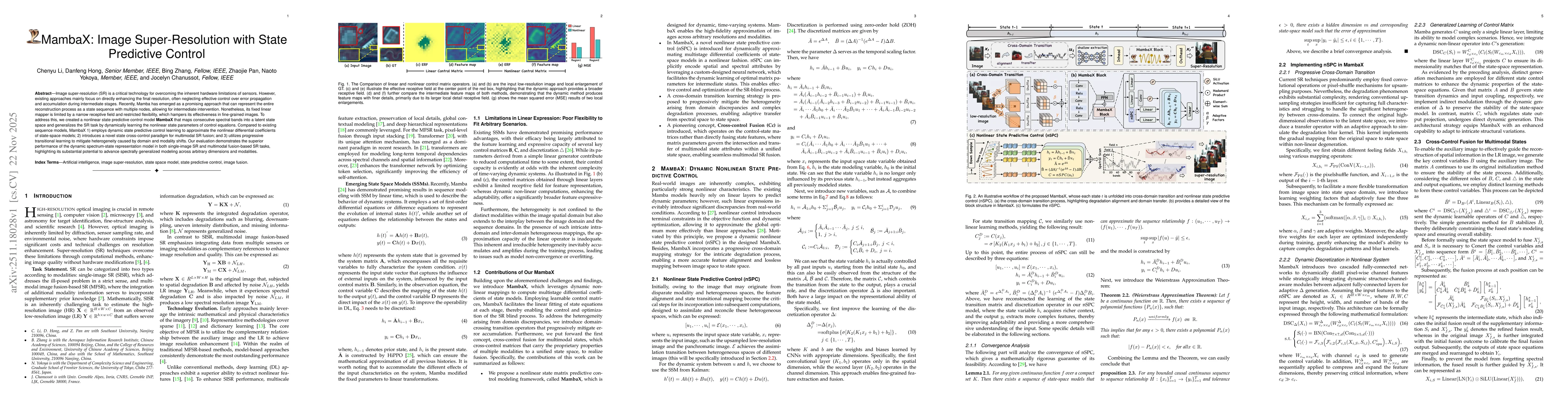
Image super-resolution (SR) is a critical technology for overcoming the inherent hardware limitations of sensors. However, existing approaches mainly focus on directly enhancing the final resolution, ...
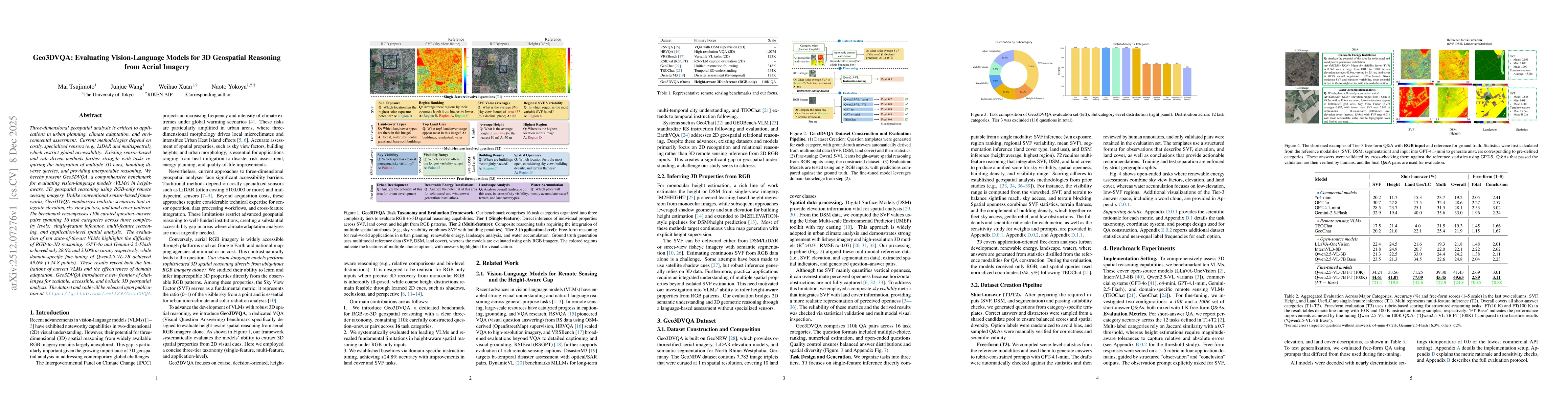
Three-dimensional geospatial analysis is critical to applications in urban planning, climate adaptation, and environmental assessment. Current methodologies depend on costly, specialized sensors (e.g....
Autonomous agents based on large language models (LLMs) are rapidly evolving to handle multi-turn tasks, but ensuring their trustworthiness remains a critical challenge. A fundamental pillar of this t...
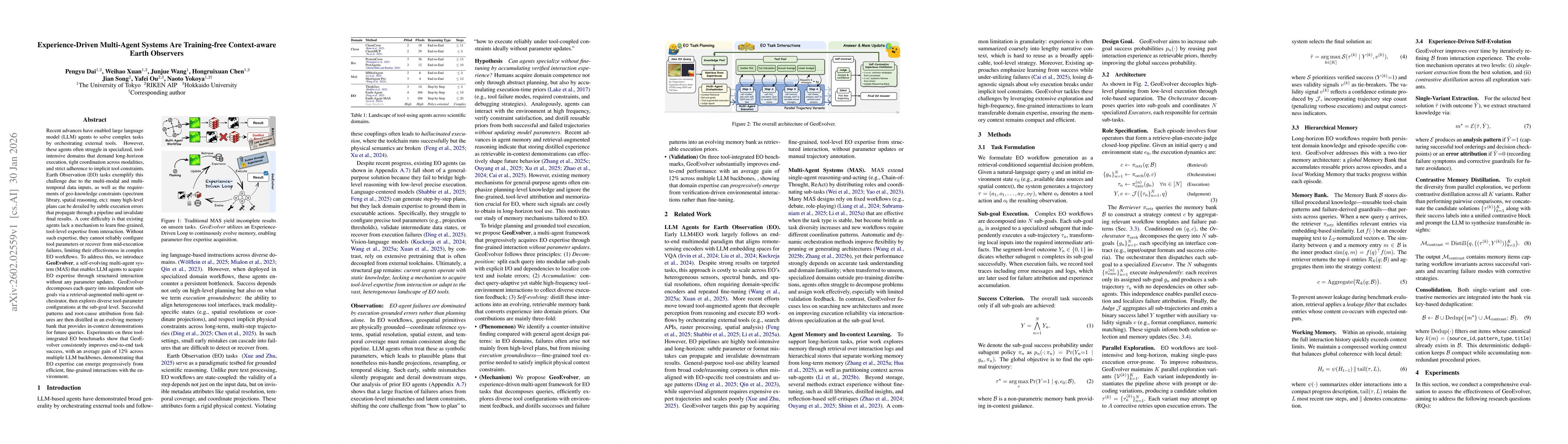
Recent advances have enabled large language model (LLM) agents to solve complex tasks by orchestrating external tools. However, these agents often struggle in specialized, tool-intensive domains that ...
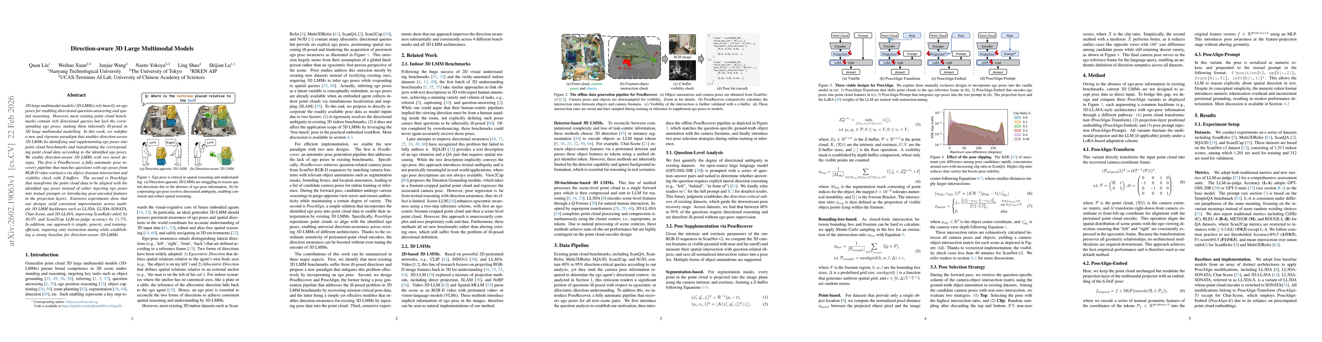
3D large multimodal models (3D LMMs) rely heavily on ego poses for enabling directional question-answering and spatial reasoning. However, most existing point cloud benchmarks contain rich directional...
Semantic segmentation of 3D LiDAR point clouds is important in urban remote sensing for understanding real-world street environments. This task, by projecting LiDAR point clouds and 3D semantic labels...
We study cross-modal super-resolution (SR) on real-world misaligned data, where only a limited number of low-resolution (LR) source and high-resolution (HR) guide image pairs with complex spatial misa...
Open-vocabulary segmentation enables pixel-level recognition from an open set of textual categories, allowing generalization beyond fixed classes. Despite great potential in remote sensing, progress i...
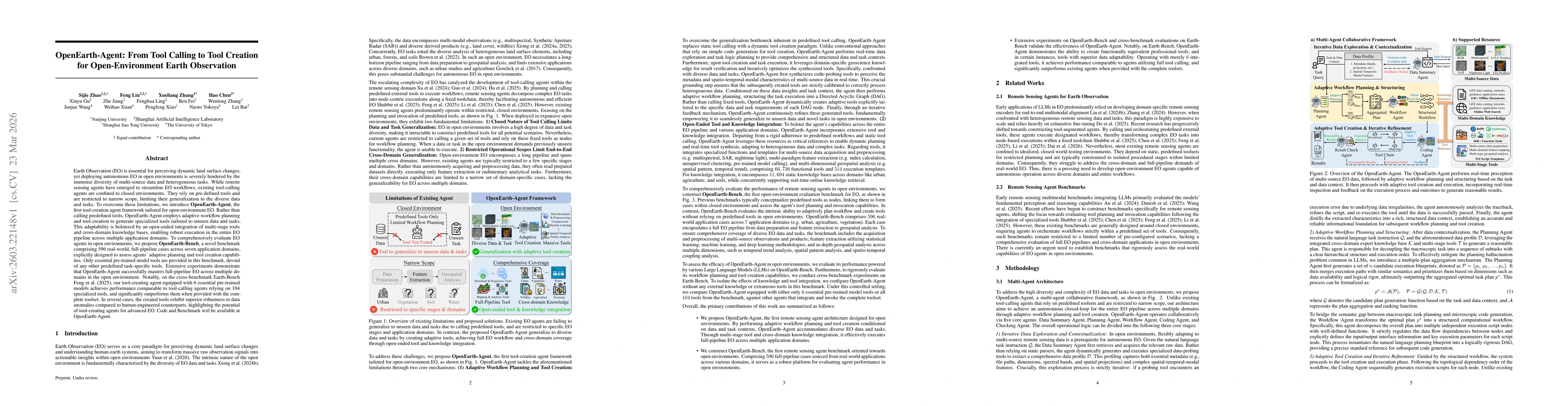
Earth Observation (EO) is essential for perceiving dynamic land surface changes, yet deploying autonomous EO in open environments is hindered by the immense diversity of multi-source data and heteroge...
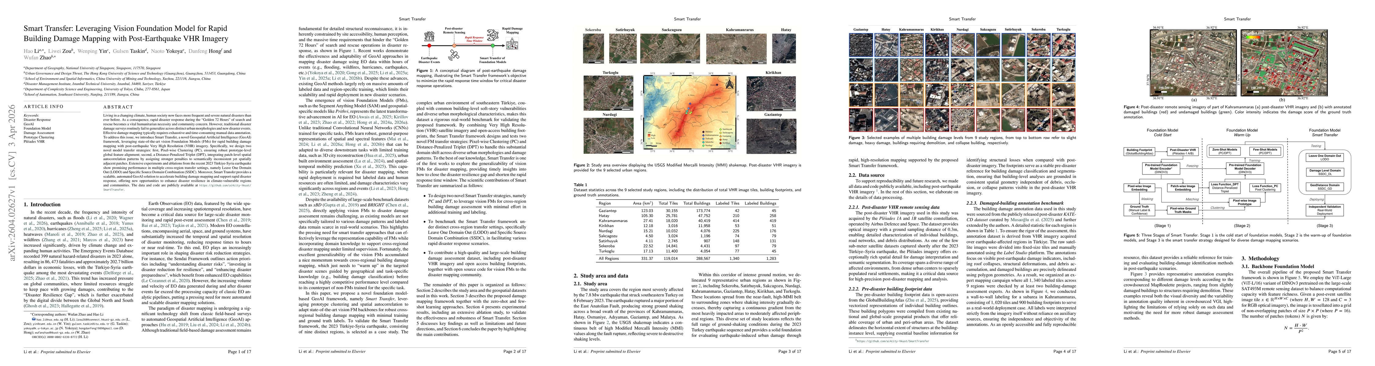
Living in a changing climate, human society now faces more frequent and severe natural disasters than ever before. As a consequence, rapid disaster response during the "Golden 72 Hours" of search and ...
Recent advances in multimodal large language models (MLLMs) have accelerated progress in domain-oriented AI, yet their development in geoscience and remote sensing (RS) remains constrained by distinct...
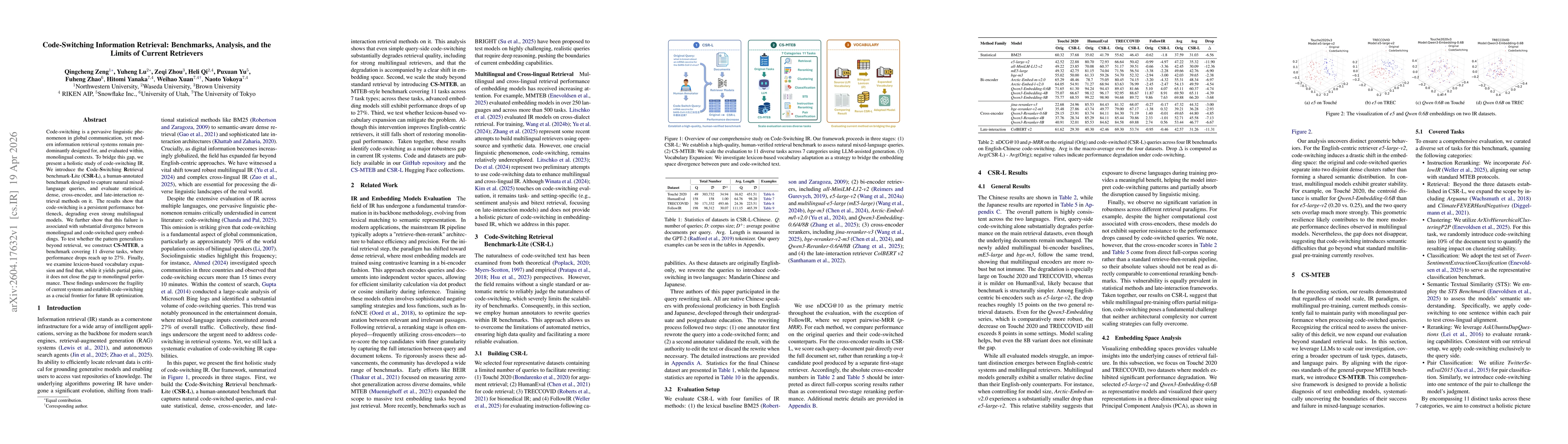
Code-switching is a pervasive linguistic phenomenon in global communication, yet modern information retrieval systems remain predominantly designed for, and evaluated within, monolingual contexts. To ...
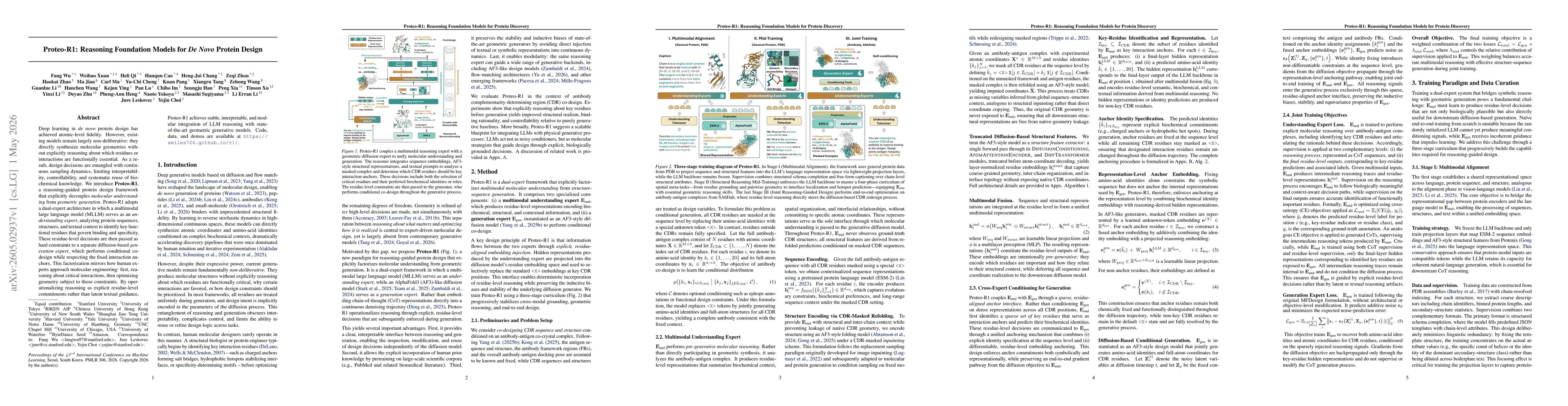
Deep learning in \emph{de novo} protein design has achieved atomic-level fidelity. However, existing models remain largely non-deliberative: they directly synthesize molecular geometries without expli...
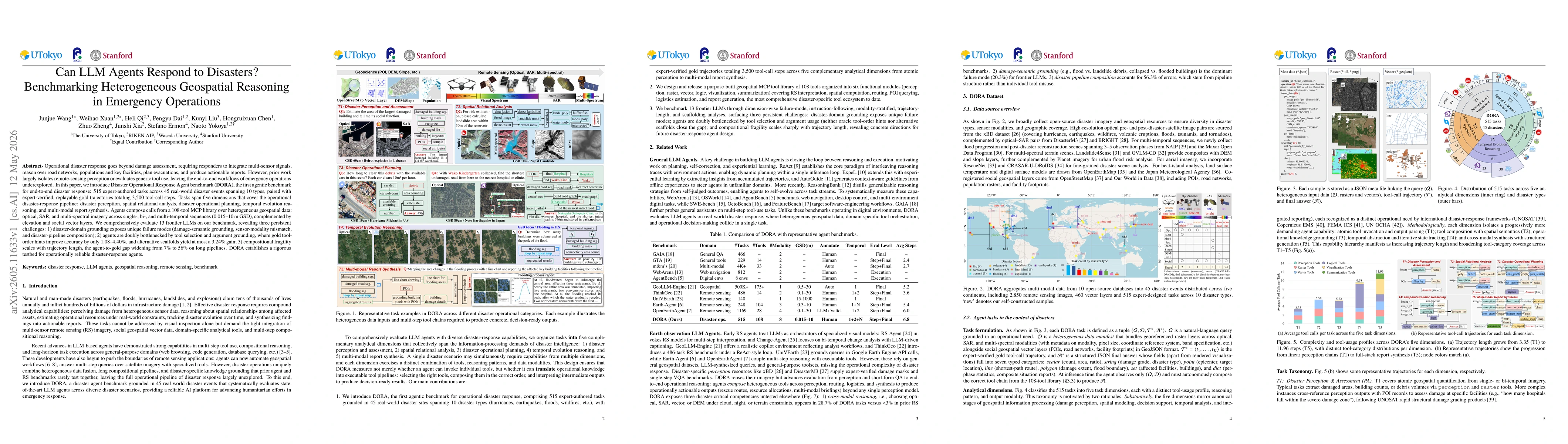
Operational disaster response goes beyond damage assessment, requiring responders to integrate multi-sensor signals, reason over road networks, populations and key facilities, plan evacuations, and pr...

Deep research agents are increasingly evaluated on their ability to search for evidence, reason over retrieved sources, and produce grounded answers. Existing browsing benchmarks, however, largely ass...
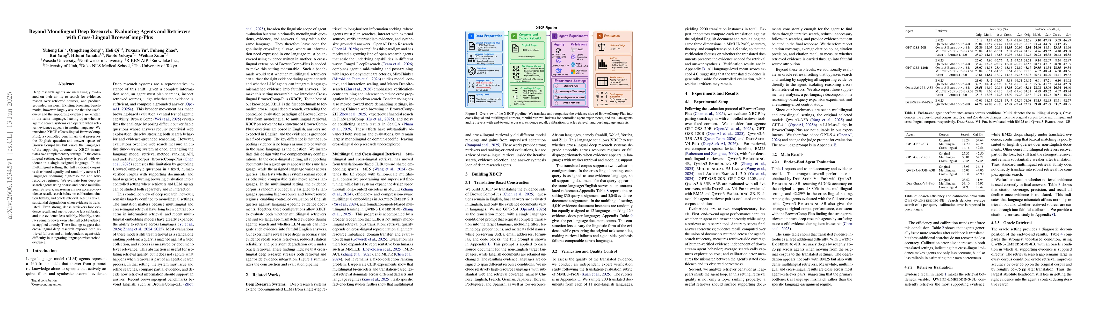
Deep research agents are increasingly evaluated on their ability to search for evidence, reason over retrieved sources, and produce grounded answers. Existing browsing benchmarks, however, largely ass...
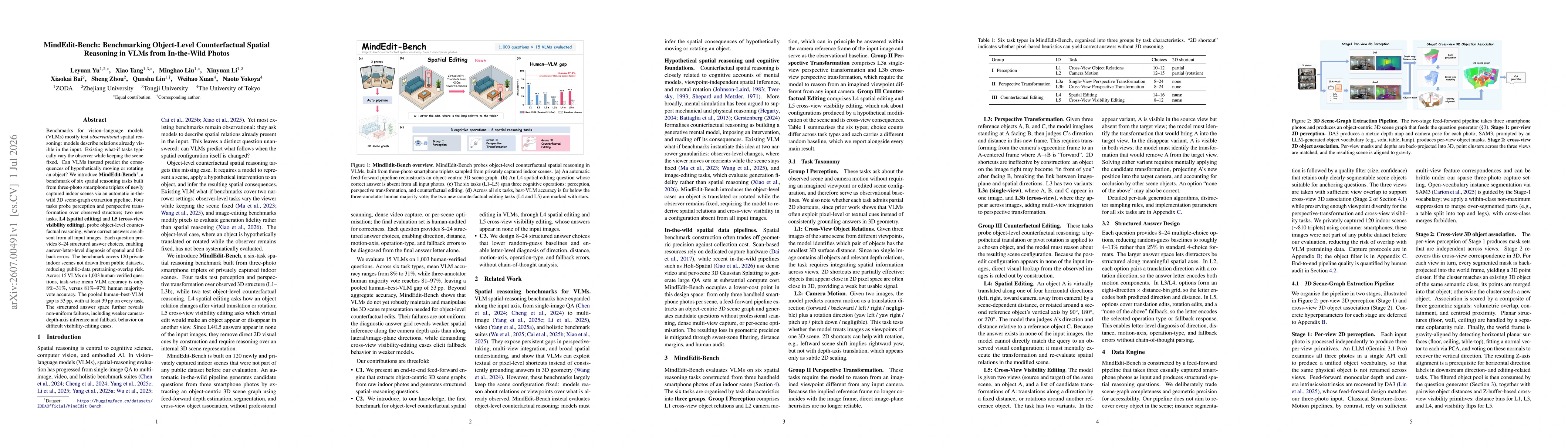
Benchmarks for vision-language models (VLMs) mostly test observational spatial reasoning: models describe relations already visible in the input. Existing what-if tasks typically vary the observer whi...