ArxivLens
J
Researcher

Junshi Xia

17 papers on arXiv

17 arXiv Papers
11 Total Publications
Profile

Academic Profile

Name Xia Junshi
Total Papers 11
Scholar Profile View on Semantic Scholar
Metrics

Statistics

17 arXiv Papers
11 Total Publications
Publications

Papers on arXiv

Thumbnail for ObjFormer: Learning Land-Cover Changes From Paired OSM Data and Optical
  High-Resolution Imagery via Object-Guided Transformer
arXiv
ObjFormer: Learning Land-Cover Changes From Paired OSM Data and Optical High-Resolution Imagery via Object-Guided Transformer

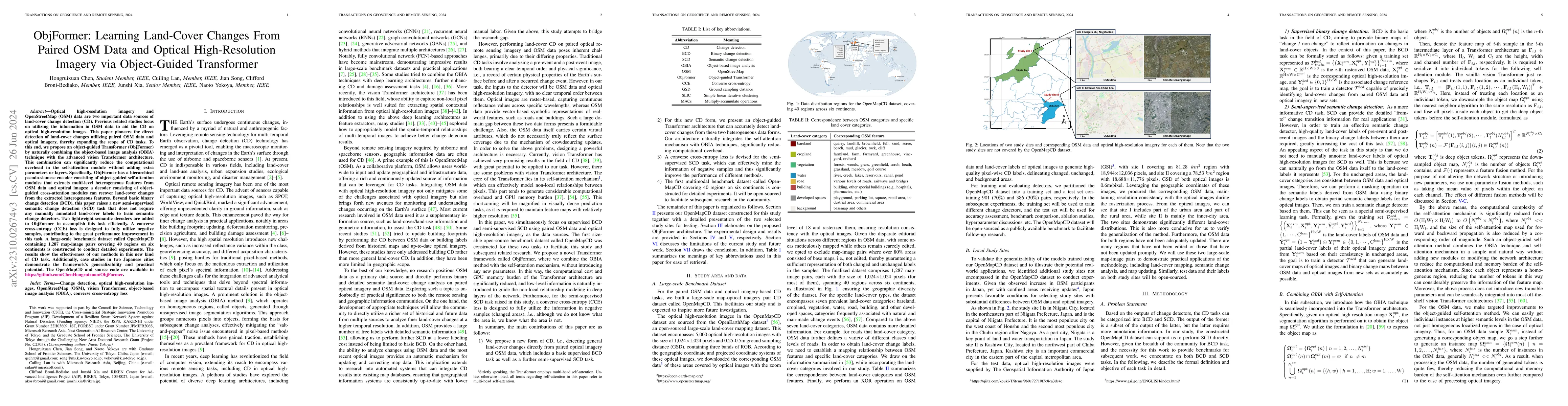
Optical high-resolution imagery and OSM data are two important data sources of change detection (CD). Previous related studies focus on utilizing the information in OSM data to aid the CD on optical h...

Thumbnail for SynRS3D: A Synthetic Dataset for Global 3D Semantic Understanding from
  Monocular Remote Sensing Imagery
arXiv
SynRS3D: A Synthetic Dataset for Global 3D Semantic Understanding from Monocular Remote Sensing Imagery

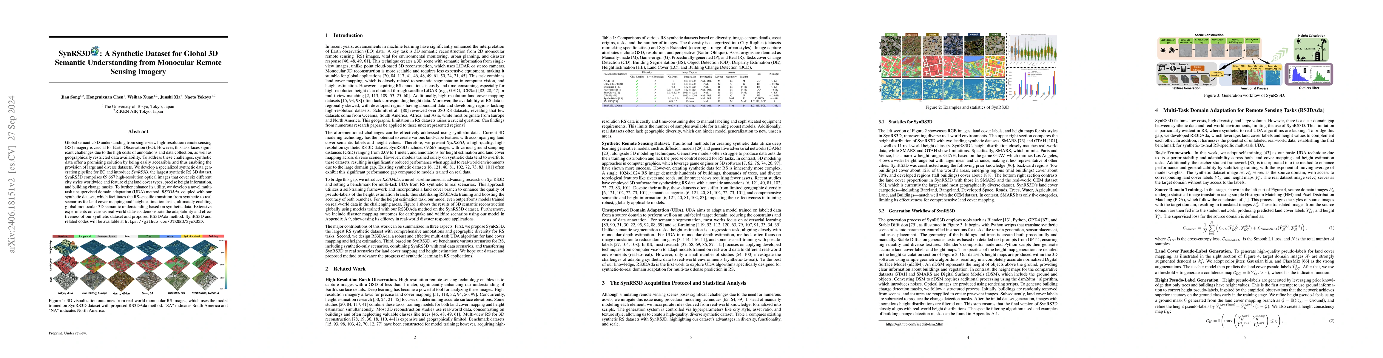
Global semantic 3D understanding from single-view high-resolution remote sensing (RS) imagery is crucial for Earth Observation (EO). However, this task faces significant challenges due to the high cos...

Thumbnail for Unsupervised Domain Adaptation Architecture Search with Self-Training
  for Land Cover Mapping
arXiv
Unsupervised Domain Adaptation Architecture Search with Self-Training for Land Cover Mapping

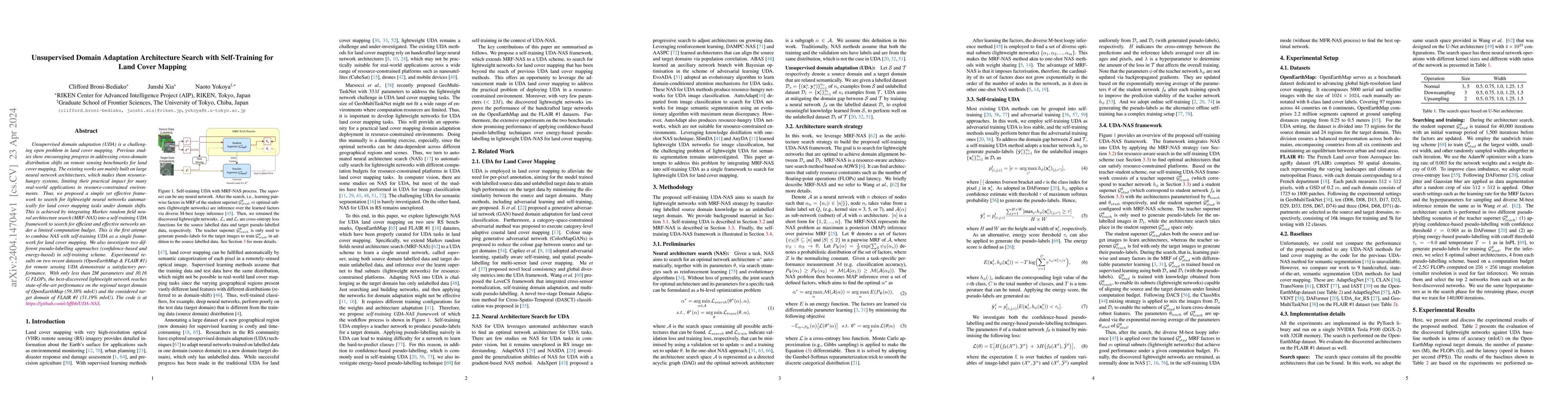
Unsupervised domain adaptation (UDA) is a challenging open problem in land cover mapping. Previous studies show encouraging progress in addressing cross-domain distribution shifts on remote sensing ...

Thumbnail for Submeter-level Land Cover Mapping of Japan
arXiv
Submeter-level Land Cover Mapping of Japan

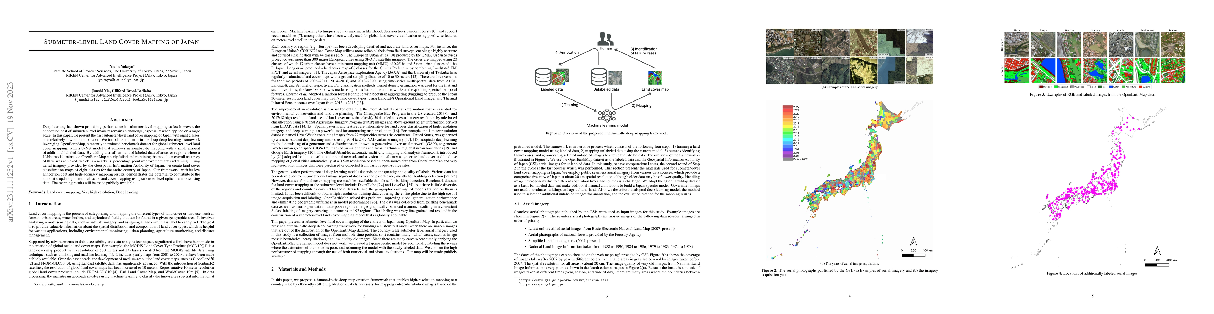
Deep learning has shown promising performance in submeter-level mapping tasks; however, the annotation cost of submeter-level imagery remains a challenge, especially when applied on a large scale. I...

Thumbnail for Real-Time Semantic Segmentation: A Brief Survey & Comparative Study in
  Remote Sensing
arXiv
Real-Time Semantic Segmentation: A Brief Survey & Comparative Study in Remote Sensing

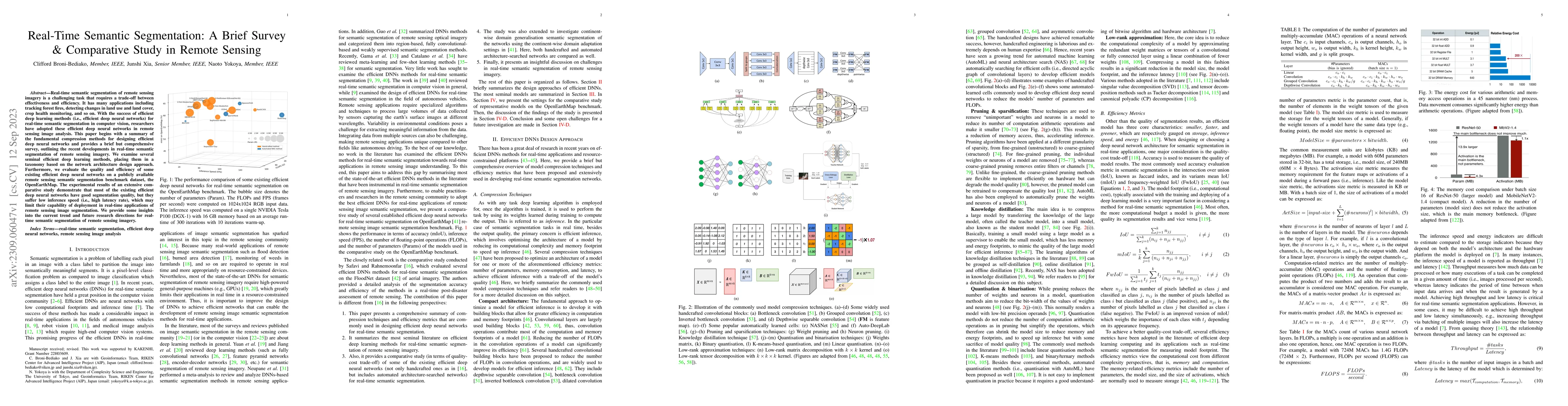
Real-time semantic segmentation of remote sensing imagery is a challenging task that requires a trade-off between effectiveness and efficiency. It has many applications including tracking forest fir...

Thumbnail for OpenEarthMap: A Benchmark Dataset for Global High-Resolution Land Cover
  Mapping
arXiv
OpenEarthMap: A Benchmark Dataset for Global High-Resolution Land Cover Mapping

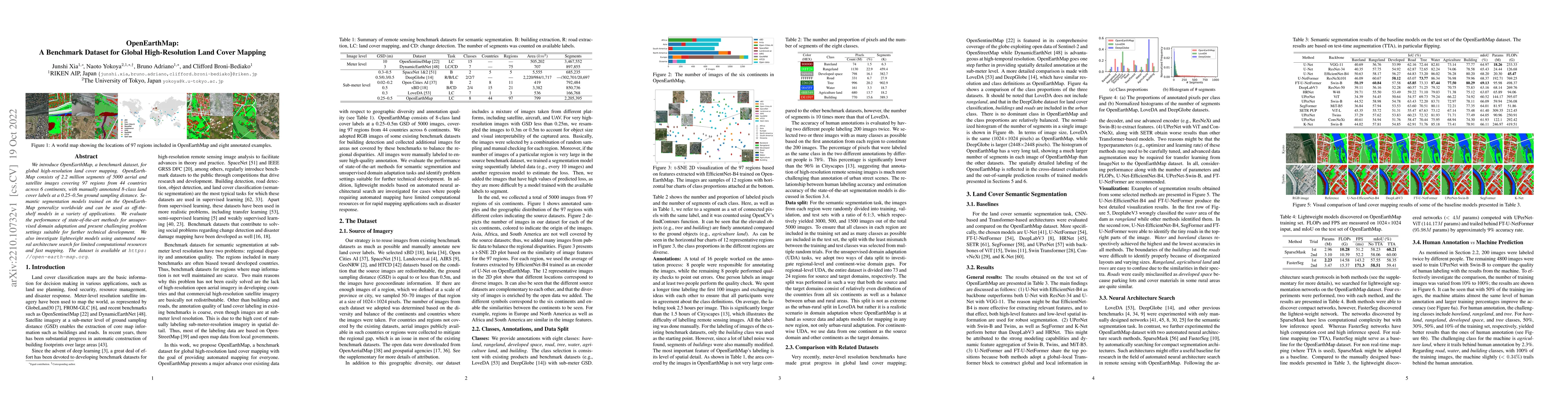
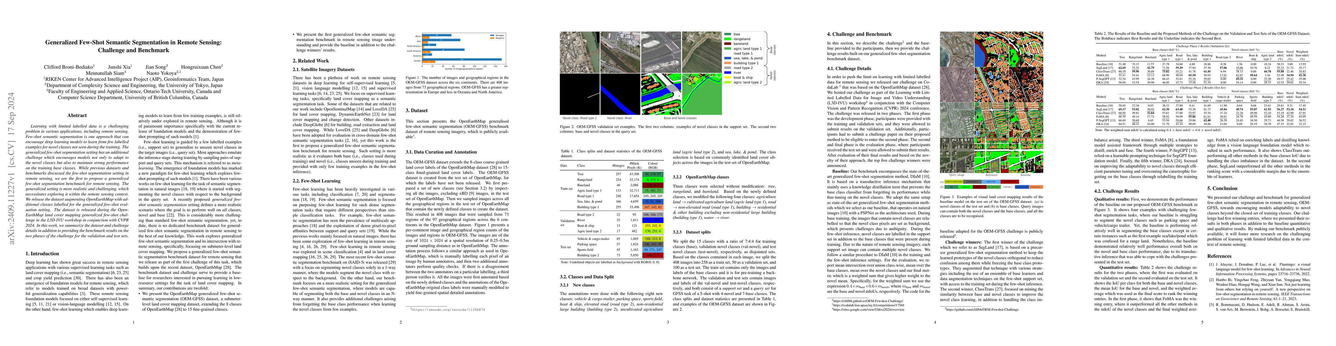
We introduce OpenEarthMap, a benchmark dataset, for global high-resolution land cover mapping. OpenEarthMap consists of 2.2 million segments of 5000 aerial and satellite images covering 97 regions f...

Thumbnail for Building Damage Mapping with Self-PositiveUnlabeled Learning
arXiv
Building Damage Mapping with Self-PositiveUnlabeled Learning

Humanitarian organizations must have fast and reliable data to respond to disasters. Deep learning approaches are difficult to implement in real-world disasters because it might be challenging to co...

Thumbnail for Learning from Multimodal and Multitemporal Earth Observation Data for
  Building Damage Mapping
arXiv
Learning from Multimodal and Multitemporal Earth Observation Data for Building Damage Mapping

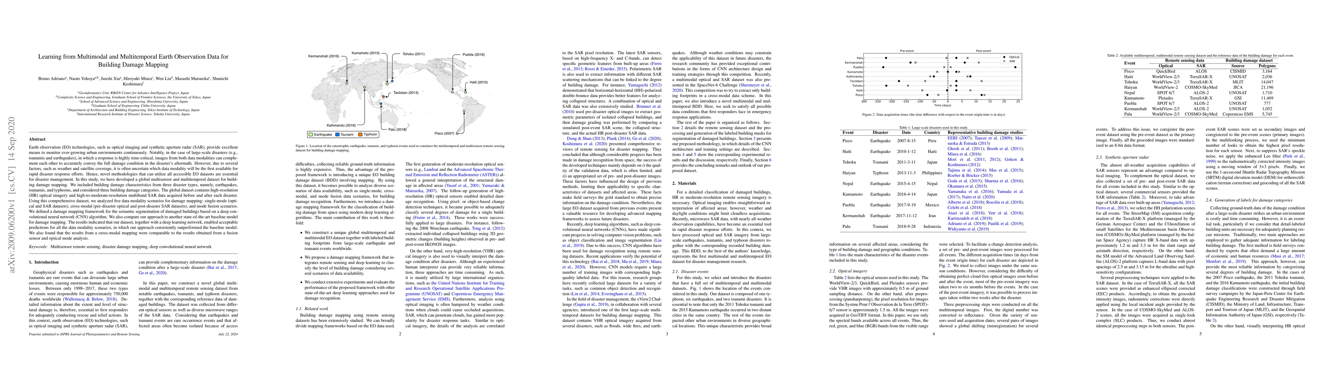
Earth observation technologies, such as optical imaging and synthetic aperture radar (SAR), provide excellent means to monitor ever-growing urban environments continuously. Notably, in the case of l...

Thumbnail for Dynamic Multi-Task Learning for Face Recognition with Facial Expression
arXiv
Dynamic Multi-Task Learning for Face Recognition with Facial Expression

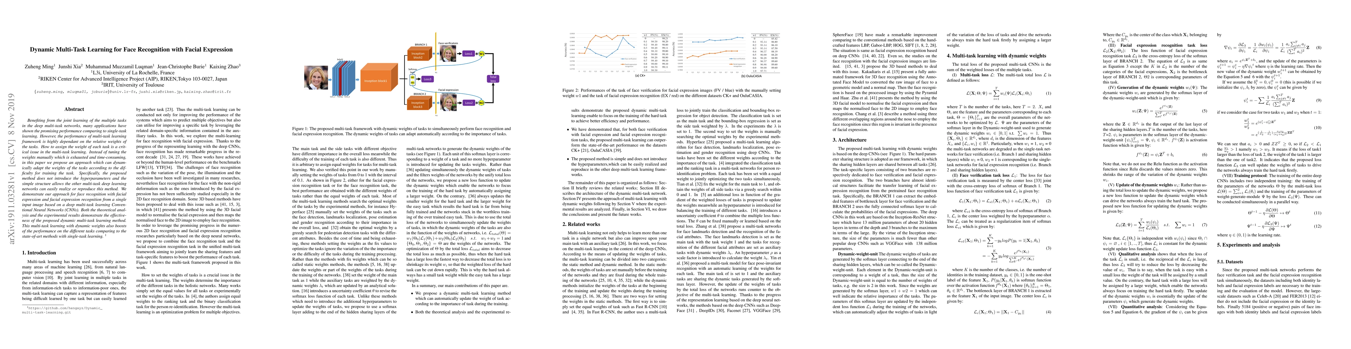
Benefiting from the joint learning of the multiple tasks in the deep multi-task networks, many applications have shown the promising performance comparing to single-task learning. However, the perfo...

Thumbnail for Generalized Few-Shot Semantic Segmentation in Remote Sensing: Challenge
  and Benchmark
arXiv
Generalized Few-Shot Semantic Segmentation in Remote Sensing: Challenge and Benchmark

Learning with limited labelled data is a challenging problem in various applications, including remote sensing. Few-shot semantic segmentation is one approach that can encourage deep learning models t...

Thumbnail for BRIGHT: A globally distributed multimodal building damage assessment
  dataset with very-high-resolution for all-weather disaster response
arXiv
BRIGHT: A globally distributed multimodal building damage assessment dataset with very-high-resolution for all-weather disaster response

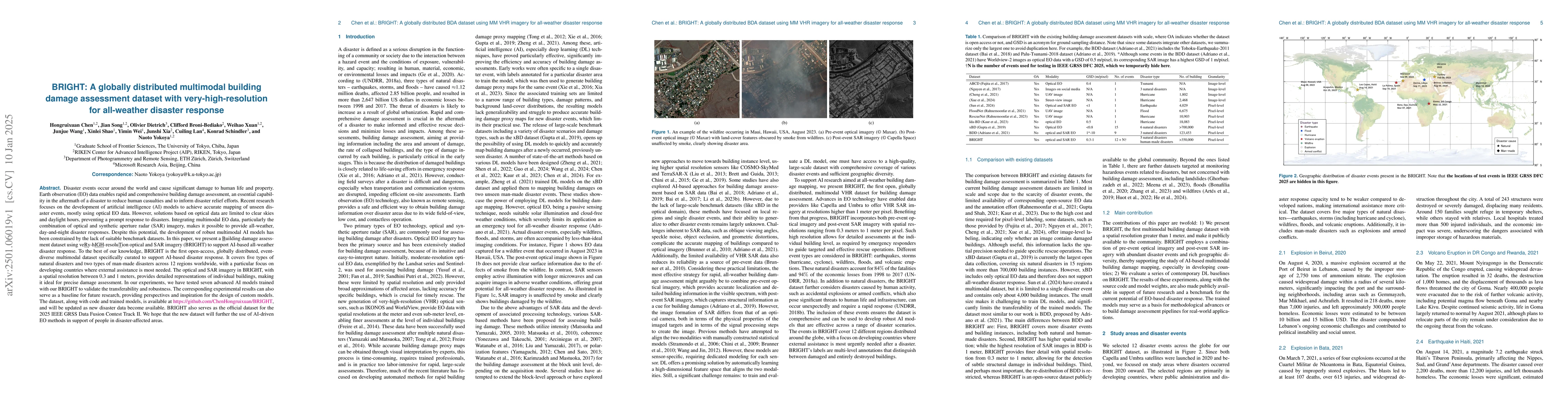
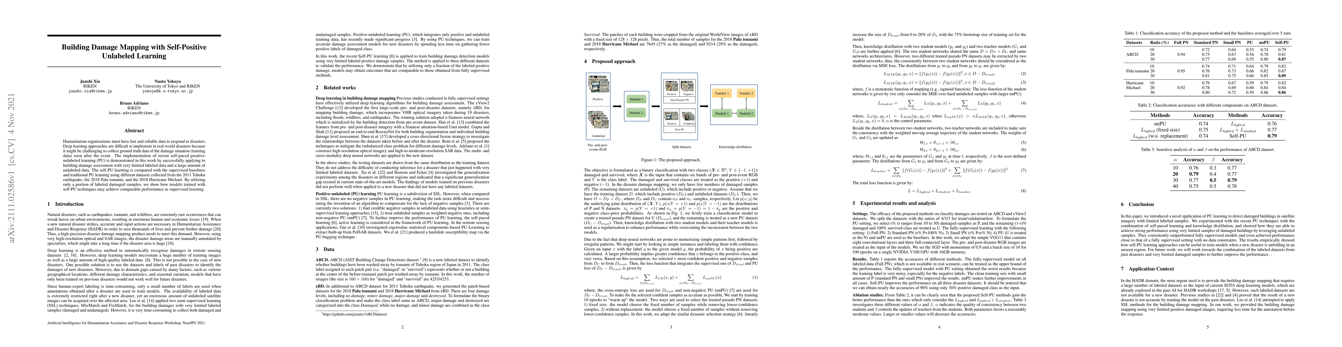
Disaster events occur around the world and cause significant damage to human life and property. Earth observation (EO) data enables rapid and comprehensive building damage assessment (BDA), an essenti...

Thumbnail for OpenEarthMap-SAR: A Benchmark Synthetic Aperture Radar Dataset for
  Global High-Resolution Land Cover Mapping
arXiv
OpenEarthMap-SAR: A Benchmark Synthetic Aperture Radar Dataset for Global High-Resolution Land Cover Mapping

High-resolution land cover mapping plays a crucial role in addressing a wide range of global challenges, including urban planning, environmental monitoring, disaster response, and sustainable developm...

Thumbnail for SARLANG-1M: A Benchmark for Vision-Language Modeling in SAR Image
  Understanding
arXiv
SARLANG-1M: A Benchmark for Vision-Language Modeling in SAR Image Understanding

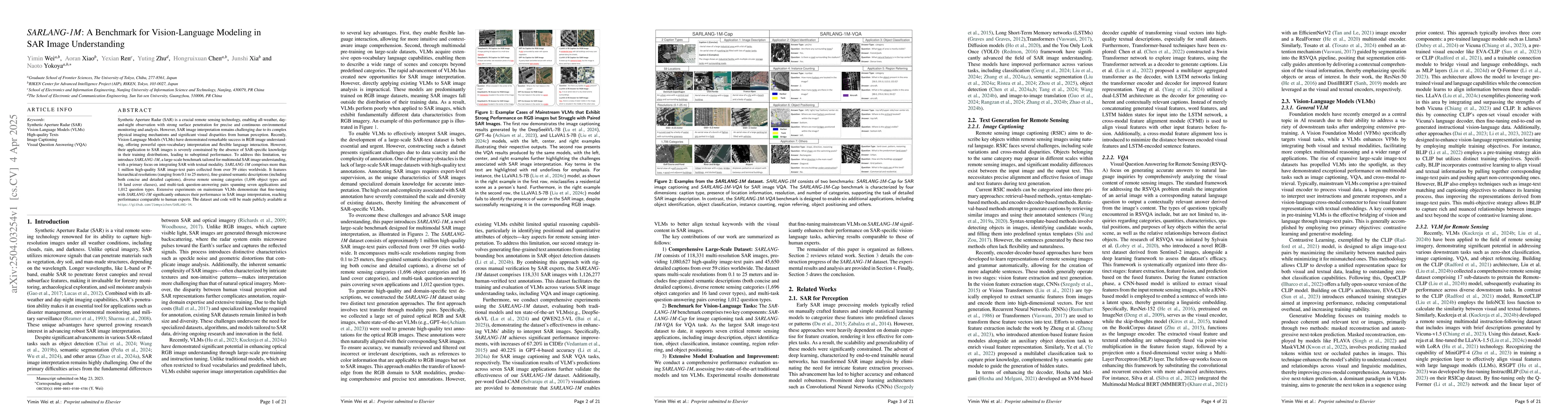
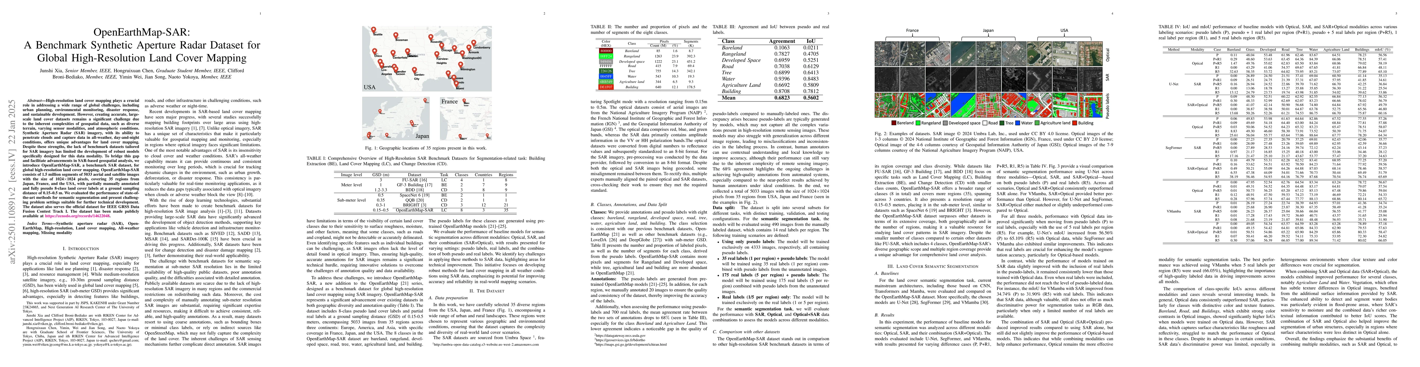
Synthetic Aperture Radar (SAR) is a crucial remote sensing technology, enabling all-weather, day-and-night observation with strong surface penetration for precise and continuous environmental monitori...

Thumbnail for DisasterM3: A Remote Sensing Vision-Language Dataset for Disaster Damage
  Assessment and Response
arXiv
DisasterM3: A Remote Sensing Vision-Language Dataset for Disaster Damage Assessment and Response

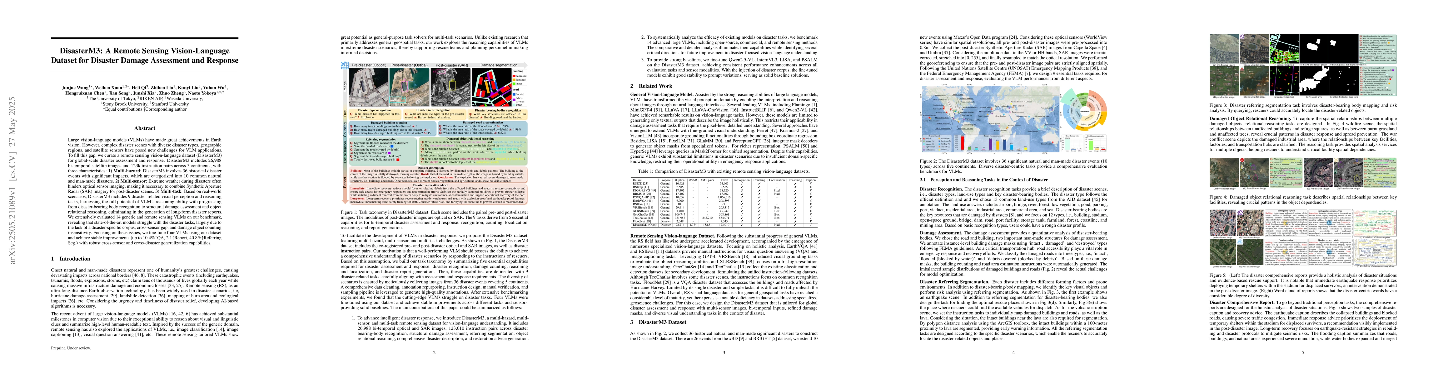
Large vision-language models (VLMs) have made great achievements in Earth vision. However, complex disaster scenes with diverse disaster types, geographic regions, and satellite sensors have posed new...

Thumbnail for DynamicVL: Benchmarking Multimodal Large Language Models for Dynamic
  City Understanding
arXiv
DynamicVL: Benchmarking Multimodal Large Language Models for Dynamic City Understanding

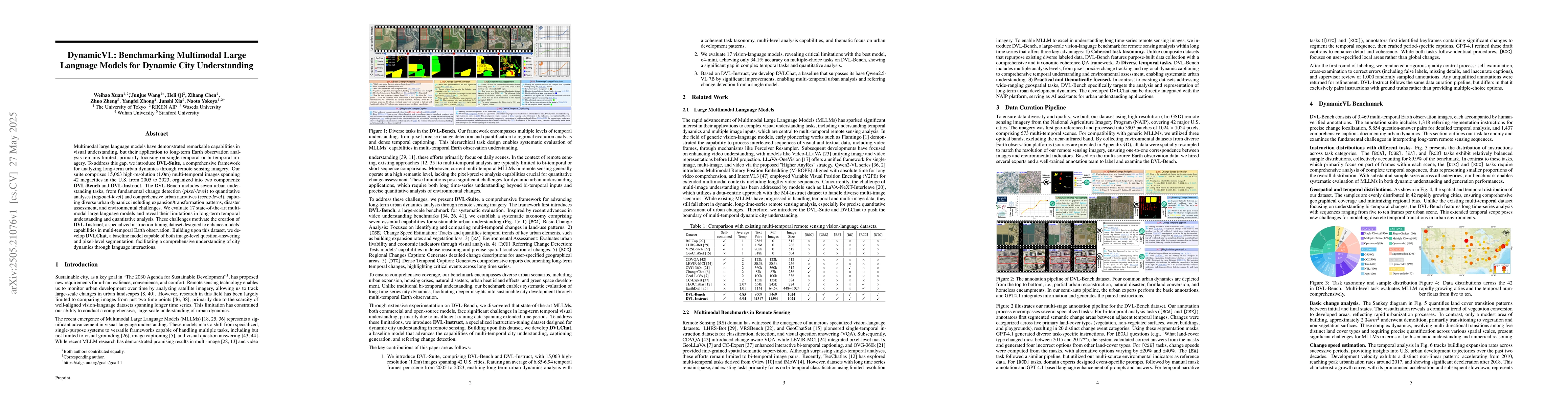
Multimodal large language models have demonstrated remarkable capabilities in visual understanding, but their application to long-term Earth observation analysis remains limited, primarily focusing on...

Thumbnail for MM-OVSeg:Multimodal Optical-SAR Fusion for Open-Vocabulary Segmentation in Remote Sensing
arXiv
MM-OVSeg:Multimodal Optical-SAR Fusion for Open-Vocabulary Segmentation in Remote Sensing

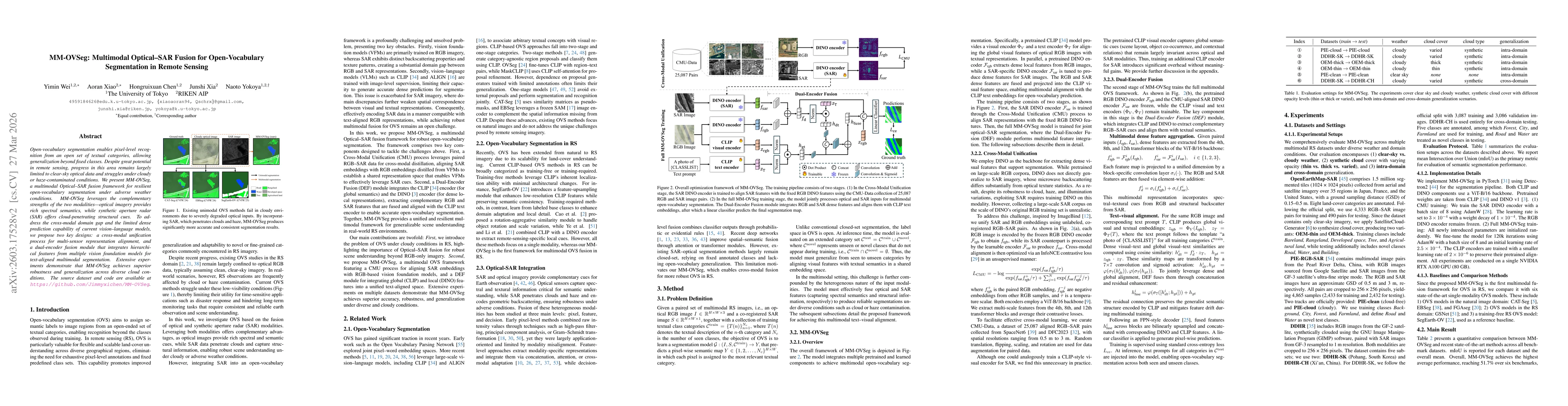
Open-vocabulary segmentation enables pixel-level recognition from an open set of textual categories, allowing generalization beyond fixed classes. Despite great potential in remote sensing, progress i...

Thumbnail for Can LLM Agents Respond to Disasters? Benchmarking Heterogeneous Geospatial Reasoning in Emergency Operations
arXiv
Can LLM Agents Respond to Disasters? Benchmarking Heterogeneous Geospatial Reasoning in Emergency Operations

Operational disaster response goes beyond damage assessment, requiring responders to integrate multi-sensor signals, reason over road networks, populations and key facilities, plan evacuations, and pr...

This website uses cookies to ensure you get the best experience. Learn more