Academic Profile
Statistics
Similar Authors
Papers on arXiv
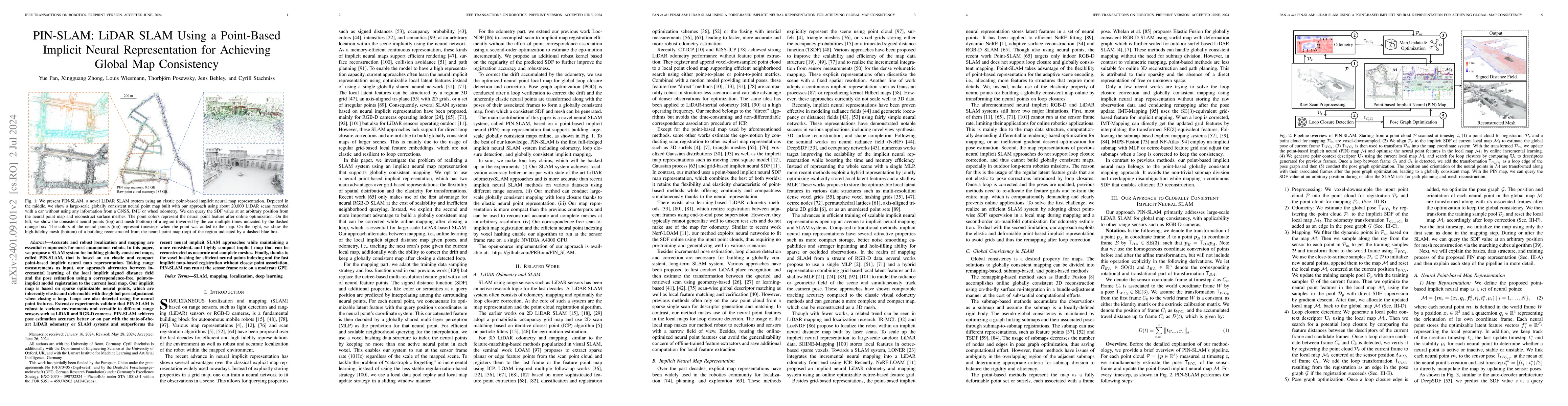
Accurate and robust localization and mapping are essential components for most autonomous robots. In this paper, we propose a SLAM system for building globally consistent maps, called PIN-SLAM, that i...
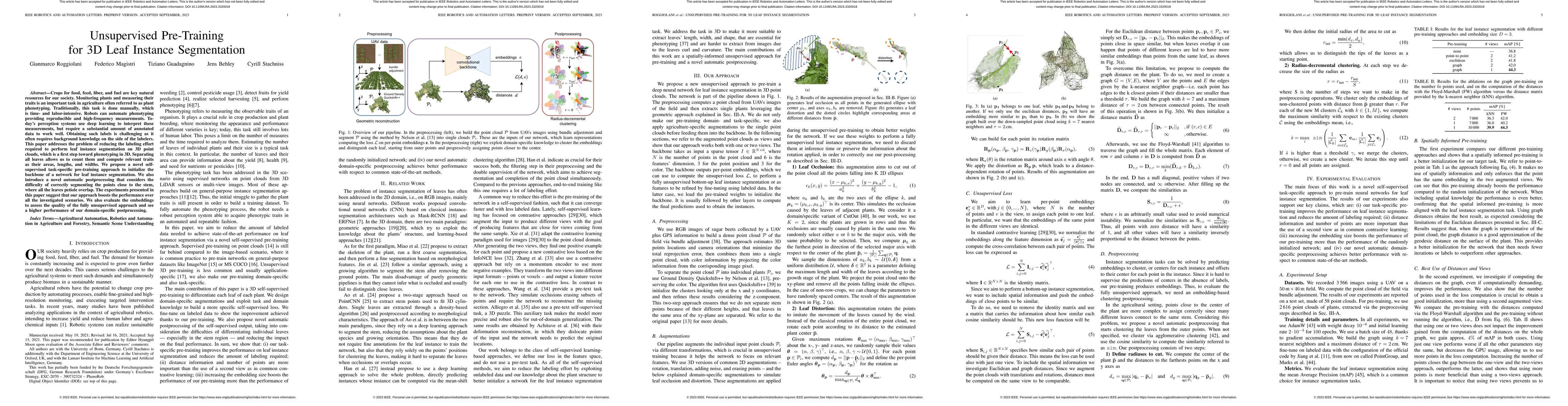
Building accurate maps is a key building block to enable reliable localization, planning, and navigation of autonomous vehicles. We propose a novel approach for building accurate maps of dynamic env...
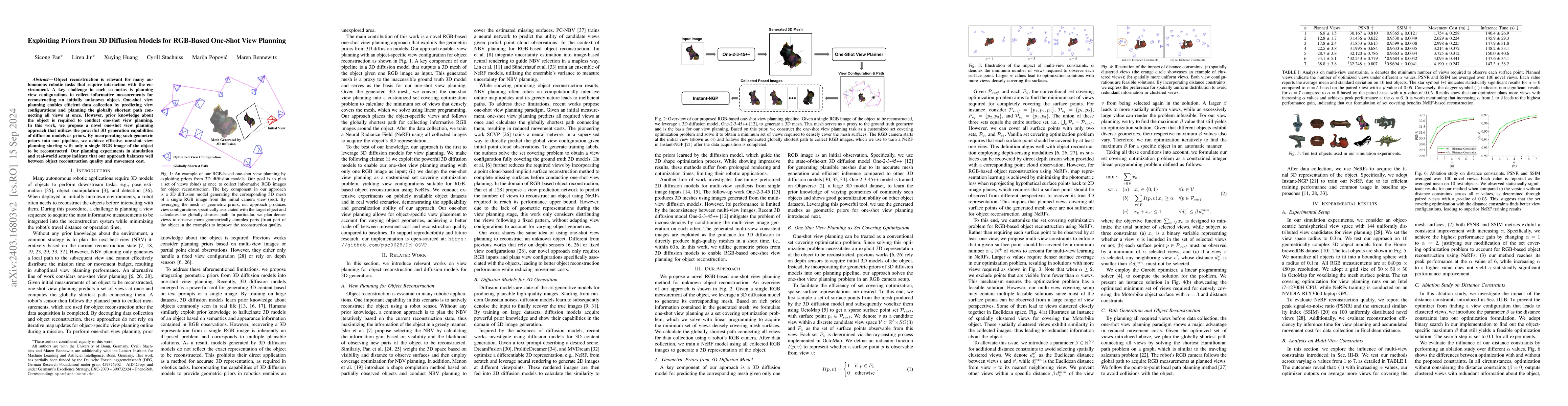
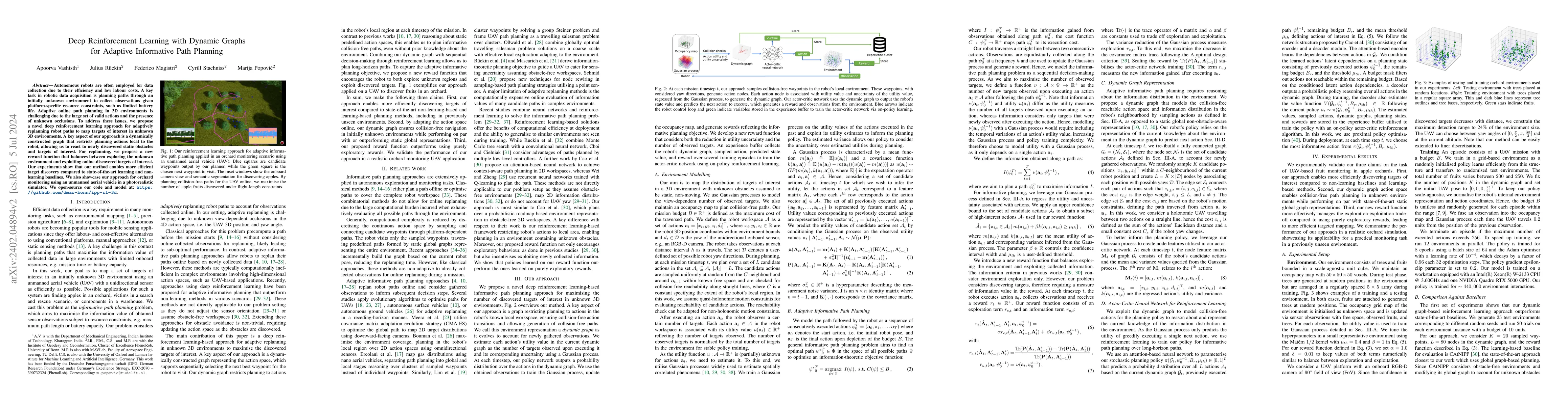
Object reconstruction is relevant for many autonomous robotic tasks that require interaction with the environment. A key challenge in such scenarios is planning view configurations to collect inform...
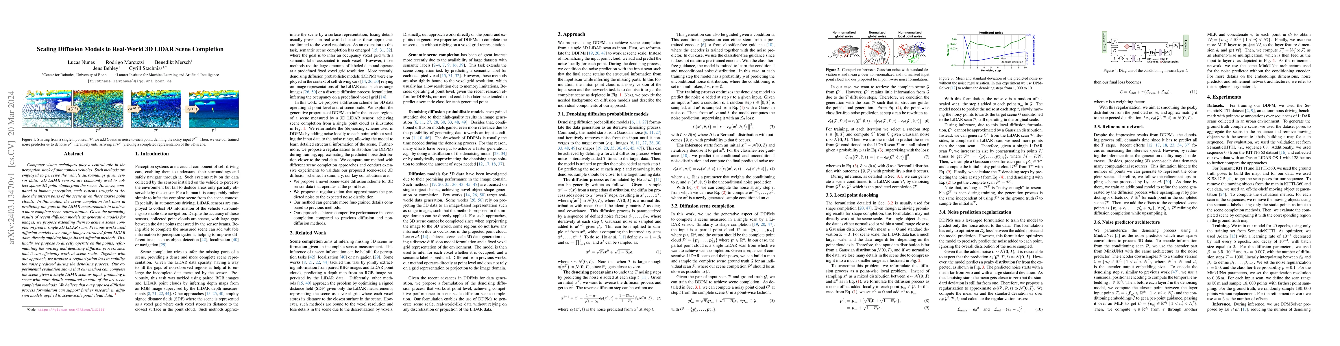
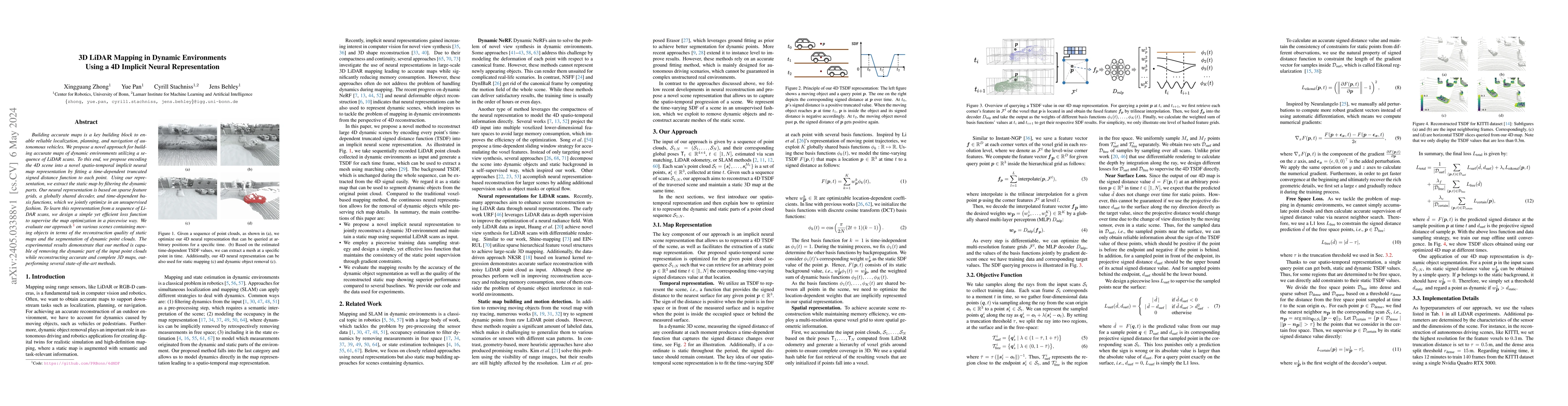
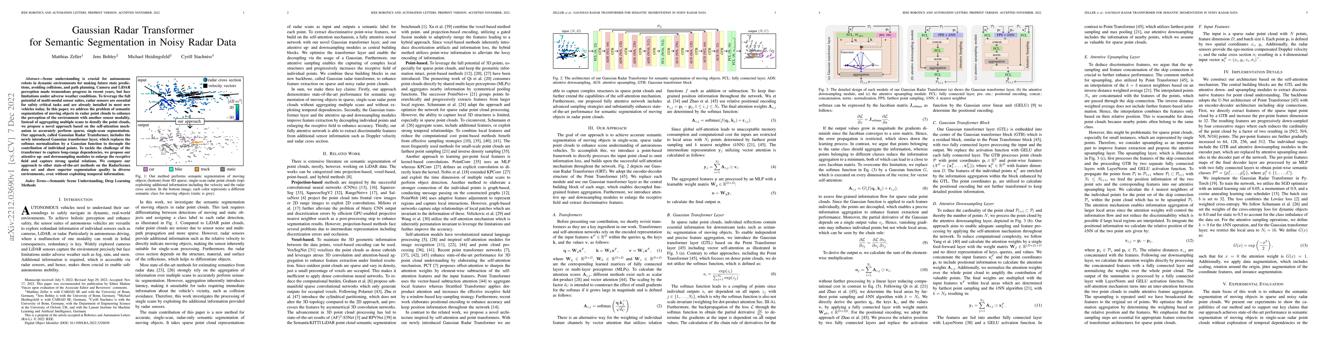
Computer vision techniques play a central role in the perception stack of autonomous vehicles. Such methods are employed to perceive the vehicle surroundings given sensor data. 3D LiDAR sensors are ...
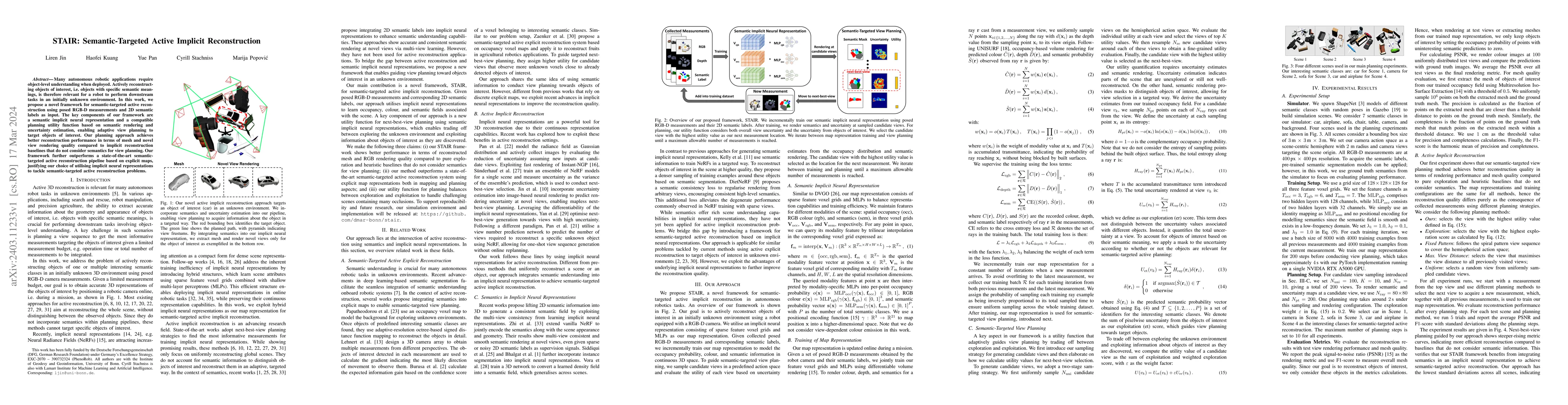
Many autonomous robotic applications require object-level understanding when deployed. Actively reconstructing objects of interest, i.e. objects with specific semantic meanings, is therefore relevan...
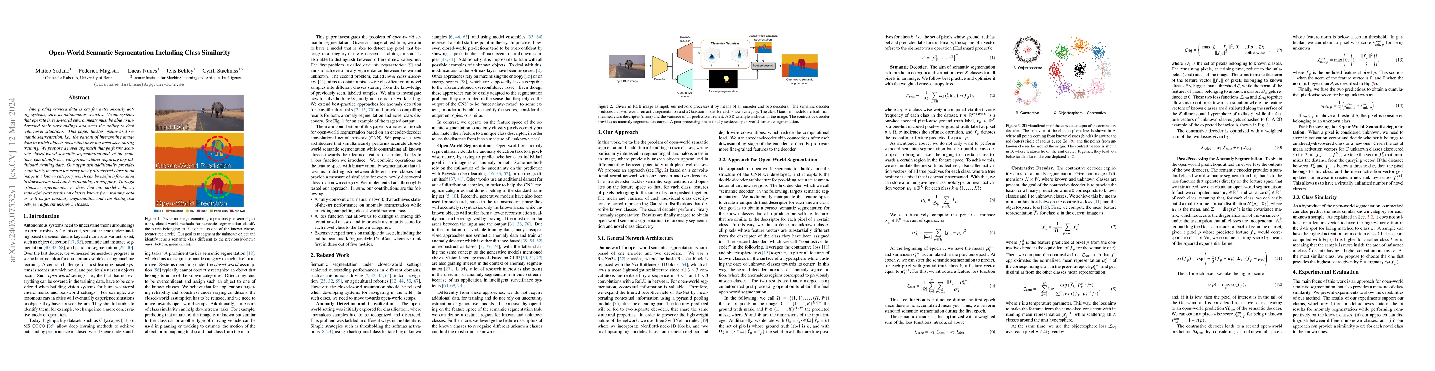
Interpreting camera data is key for autonomously acting systems, such as autonomous vehicles. Vision systems that operate in real-world environments must be able to understand their surroundings and...
Autonomous robots are often employed for data collection due to their efficiency and low labour costs. A key task in robotic data acquisition is planning paths through an initially unknown environme...
Crops for food, feed, fiber, and fuel are key natural resources for our society. Monitoring plants and measuring their traits is an important task in agriculture often referred to as plant phenotypi...
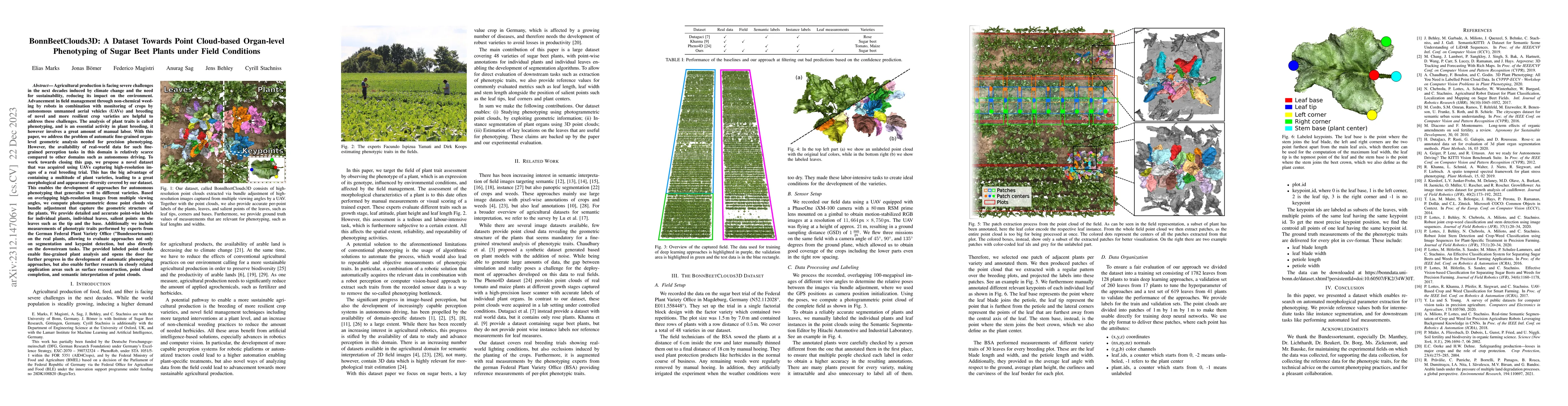
Agricultural production is facing severe challenges in the next decades induced by climate change and the need for sustainability, reducing its impact on the environment. Advancements in field manag...
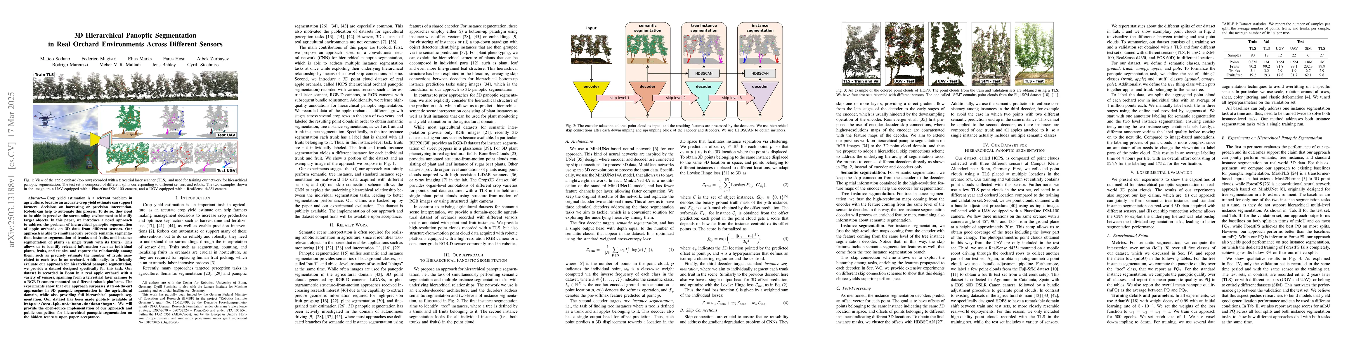
Semantic segmentation enables robots to perceive and reason about their environments beyond geometry. Most of such systems build upon deep learning approaches. As autonomous robots are commonly depl...
In response to the increasing global demand for food, feed, fiber, and fuel, digital agriculture is rapidly evolving to meet these demands while reducing environmental impact. This evolution involve...
Odometry estimation is crucial for every autonomous system requiring navigation in an unknown environment. In modern mobile robots, 3D LiDAR-inertial systems are often used for this task. By fusing ...
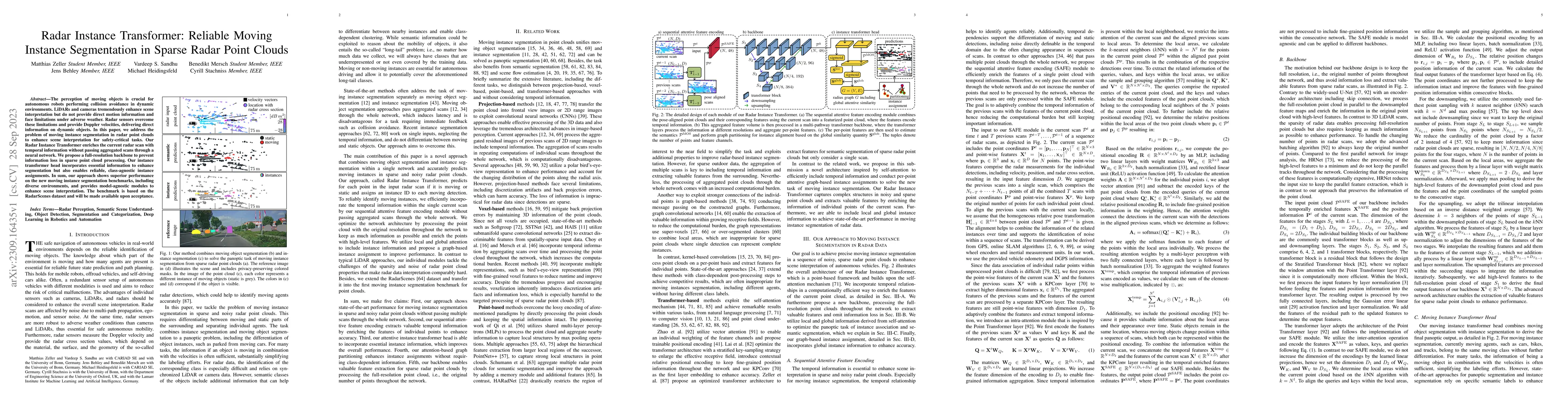
The perception of moving objects is crucial for autonomous robots performing collision avoidance in dynamic environments. LiDARs and cameras tremendously enhance scene interpretation but do not prov...
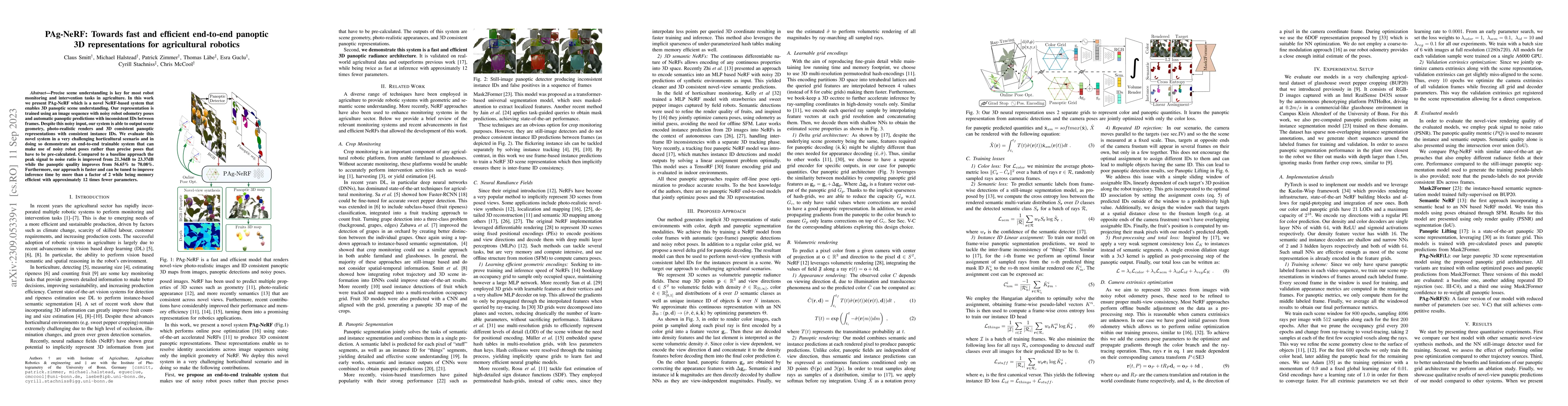
Precise scene understanding is key for most robot monitoring and intervention tasks in agriculture. In this work we present PAg-NeRF which is a novel NeRF-based system that enables 3D panoptic scene...
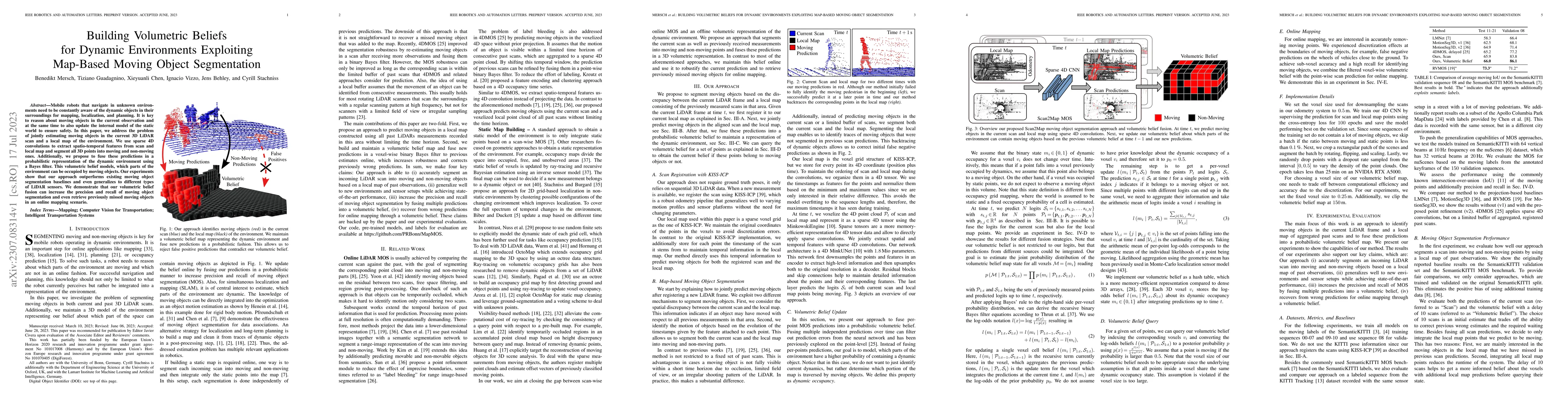
Mobile robots that navigate in unknown environments need to be constantly aware of the dynamic objects in their surroundings for mapping, localization, and planning. It is key to reason about moving...
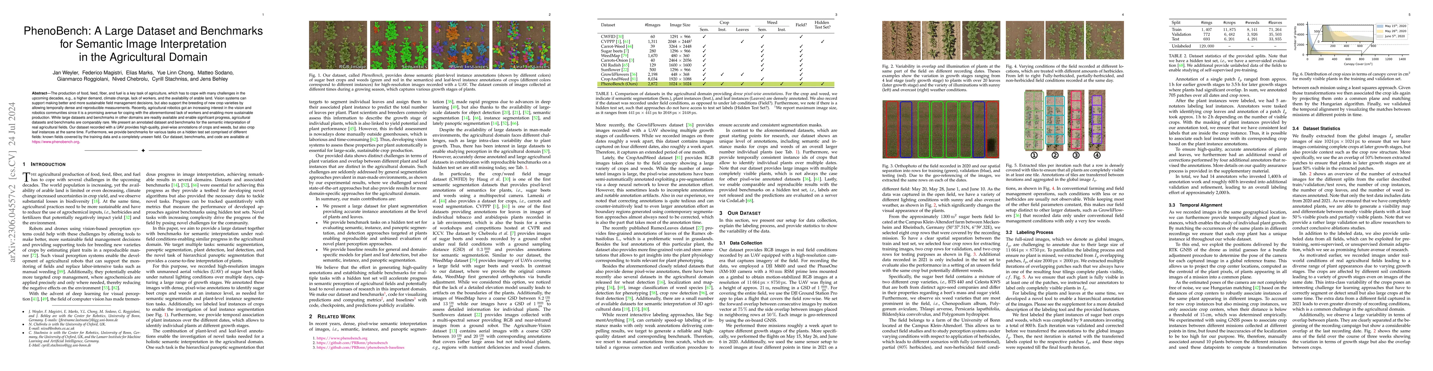
The production of food, feed, fiber, and fuel is a key task of agriculture. Especially crop production has to cope with a multitude of challenges in the upcoming decades caused by a growing world po...
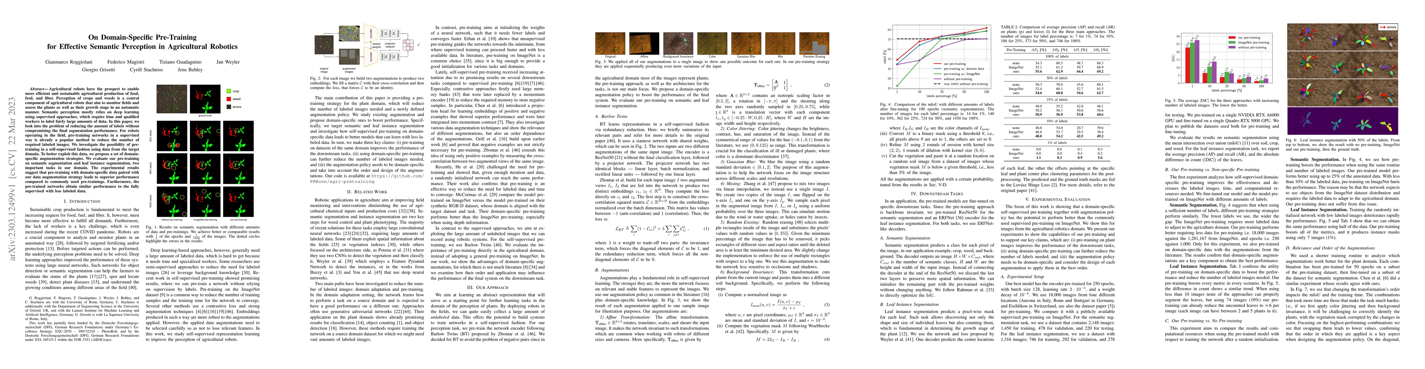
Agricultural robots have the prospect to enable more efficient and sustainable agricultural production of food, feed, and fiber. Perception of crops and weeds is a central component of agricultural ...
Object-based maps are relevant for scene understanding since they integrate geometric and semantic information of the environment, allowing autonomous robots to robustly localize and interact with o...
Monitoring plants and fruits at high resolution play a key role in the future of agriculture. Accurate 3D information can pave the way to a diverse number of robotic applications in agriculture rang...
Knowledge about the own pose is key for all mobile robot applications. Thus pose estimation is part of the core functionalities of mobile robots. Over the last two decades, LiDAR scanners have becom...
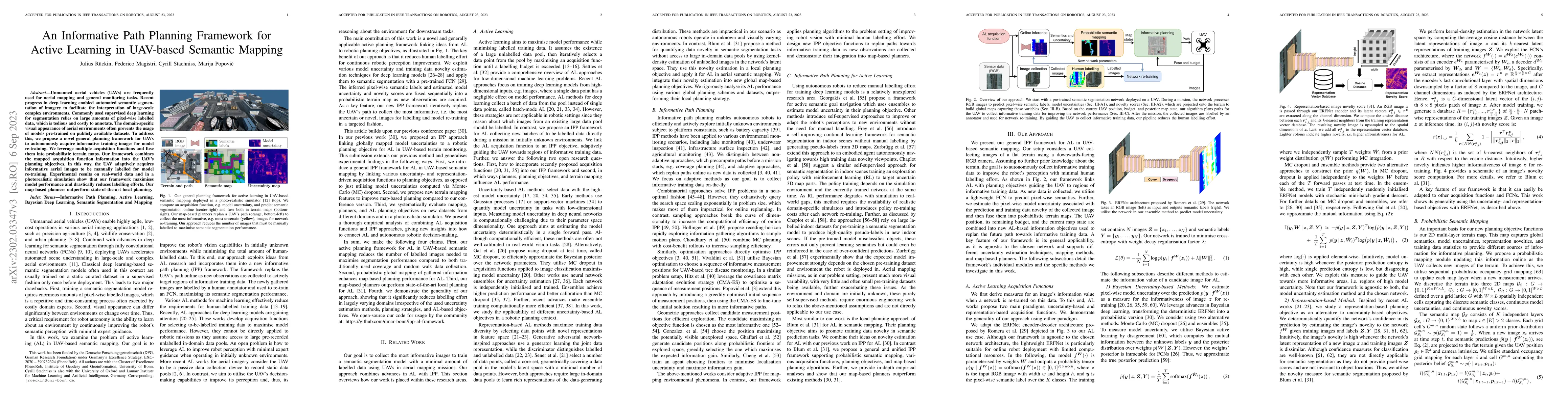
Unmanned aerial vehicles (UAVs) are frequently used for aerial mapping and general monitoring tasks. Recent progress in deep learning enabled automated semantic segmentation of imagery to facilitate...
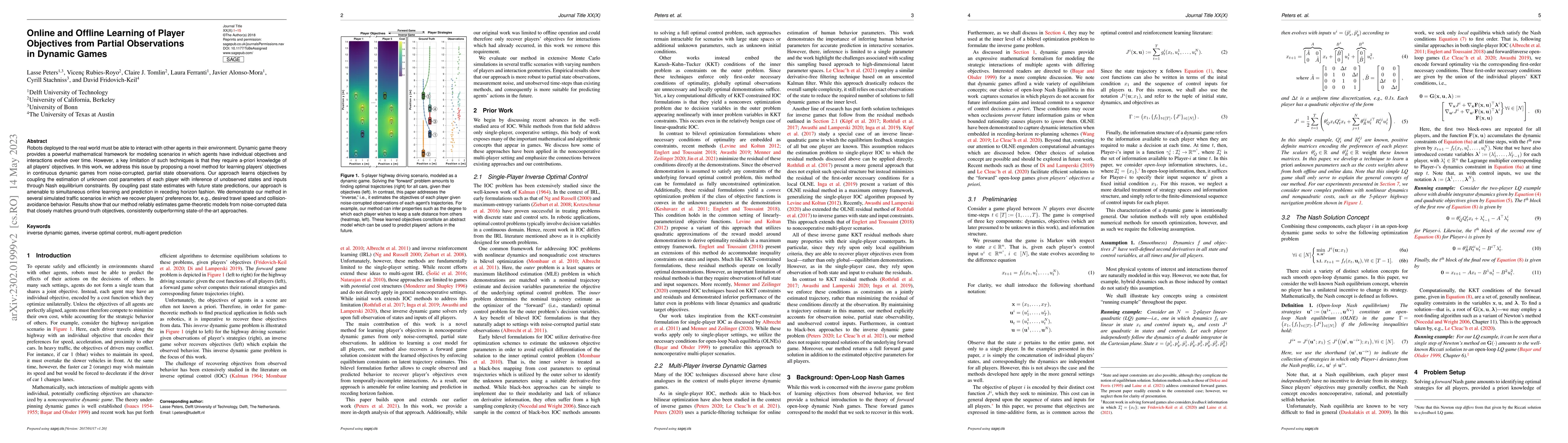
Robots deployed to the real world must be able to interact with other agents in their environment. Dynamic game theory provides a powerful mathematical framework for modeling scenarios in which agen...
Scene understanding is crucial for autonomous robots in dynamic environments for making future state predictions, avoiding collisions, and path planning. Camera and LiDAR perception made tremendous ...
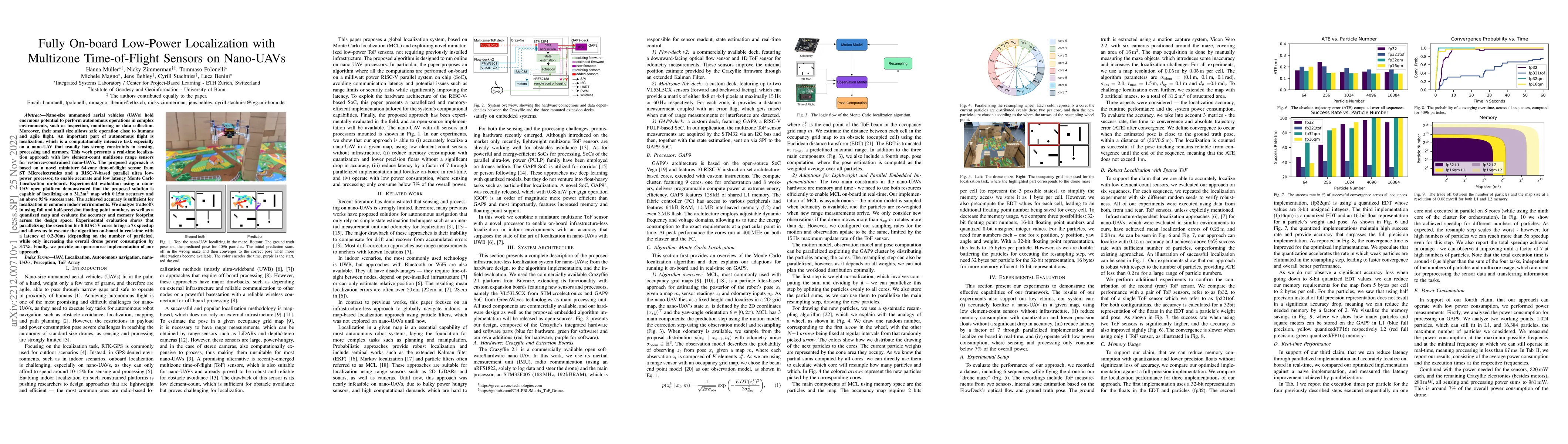
Nano-size unmanned aerial vehicles (UAVs) hold enormous potential to perform autonomous operations in complex environments, such as inspection, monitoring or data collection. Moreover, their small s...
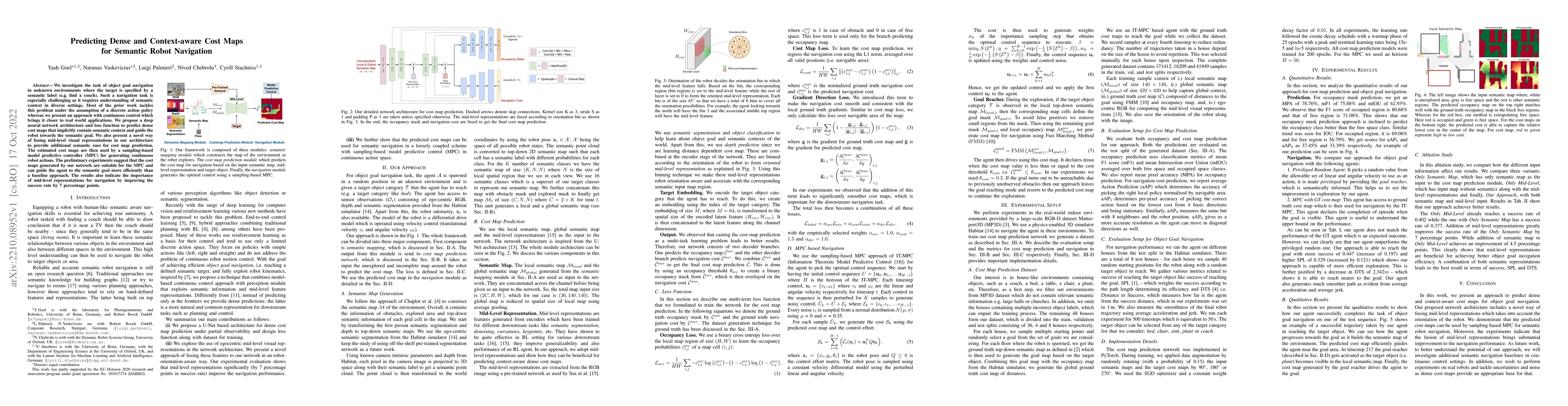
We investigate the task of object goal navigation in unknown environments where the target is specified by a semantic label (e.g. find a couch). Such a navigation task is especially challenging as i...
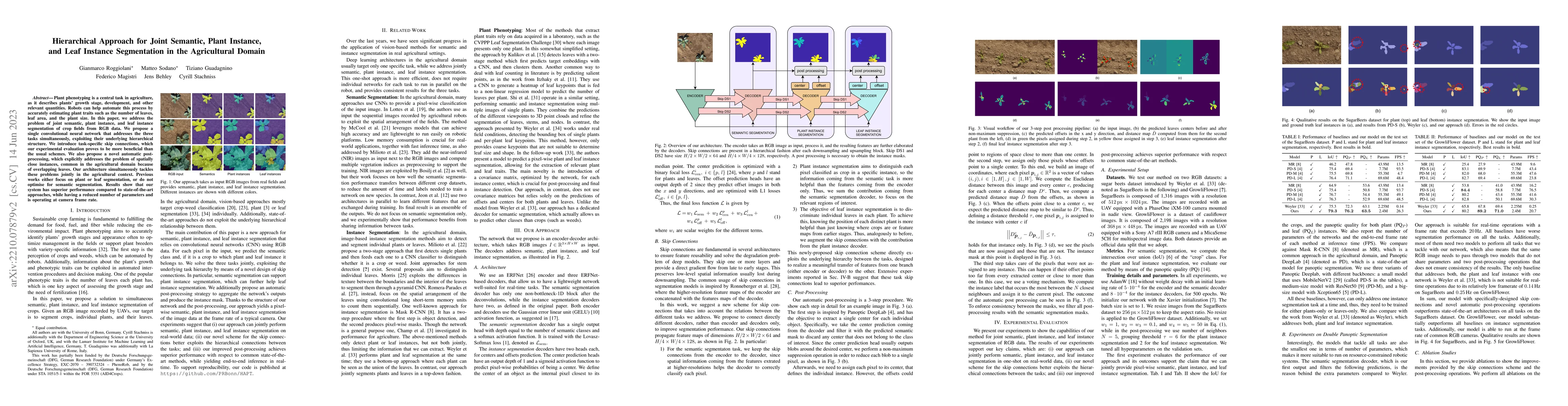
Plant phenotyping is a central task in agriculture, as it describes plants' growth stage, development, and other relevant quantities. Robots can help automate this process by accurately estimating p...
Determining the state of a mobile robot is an essential building block of robot navigation systems. In this paper, we address the problem of estimating the robots pose in an indoor environment using...
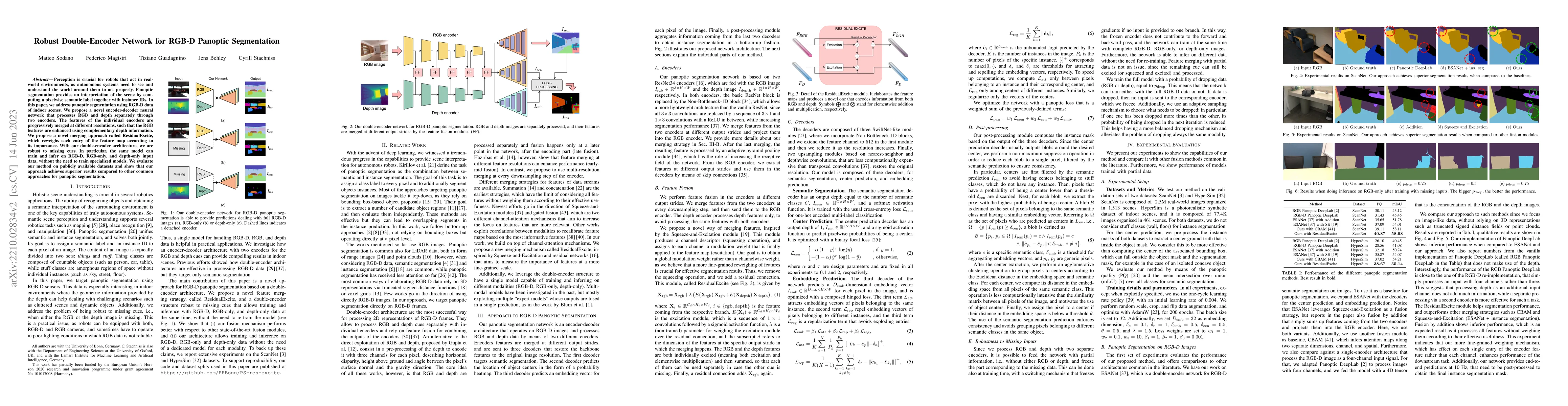
Perception is crucial for robots that act in real-world environments, as autonomous systems need to see and understand the world around them to act properly. Panoptic segmentation provides an interp...
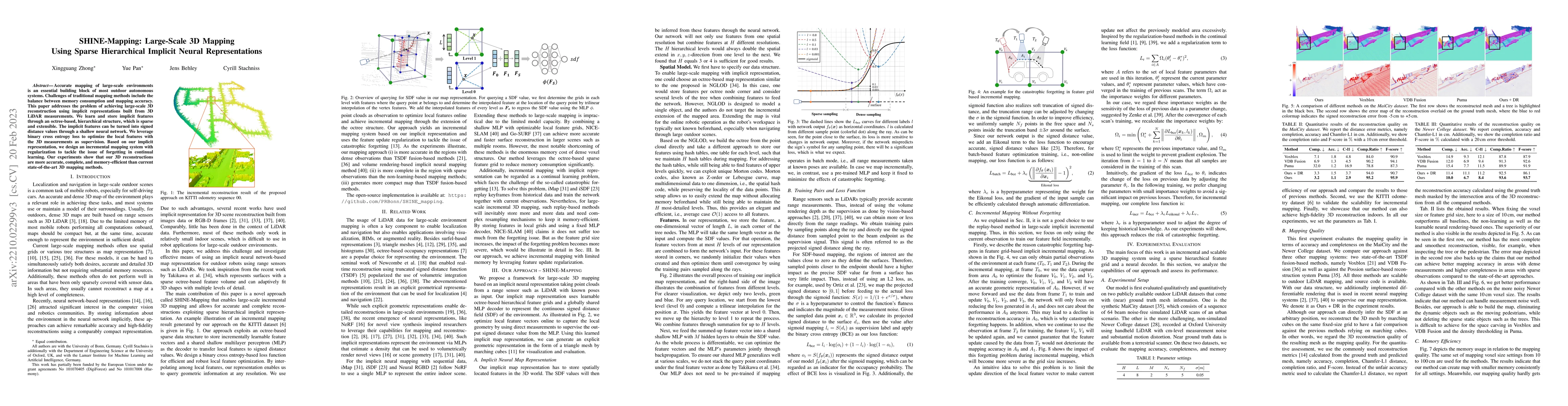
Accurate mapping of large-scale environments is an essential building block of most outdoor autonomous systems. Challenges of traditional mapping methods include the balance between memory consumpti...
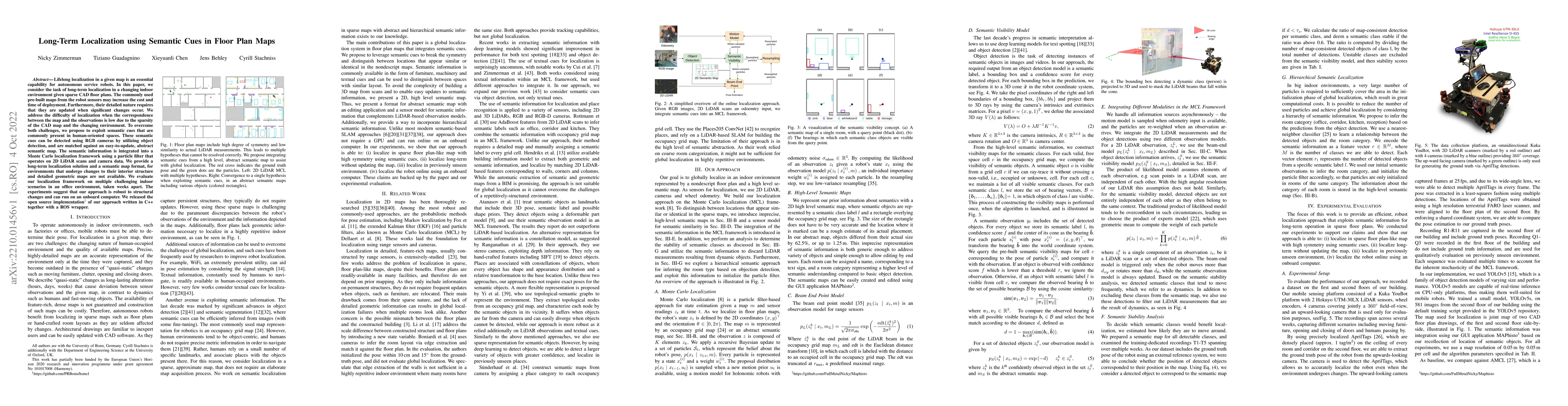
Lifelong localization in a given map is an essential capability for autonomous service robots. In this paper, we consider the task of long-term localization in a changing indoor environment given sp...
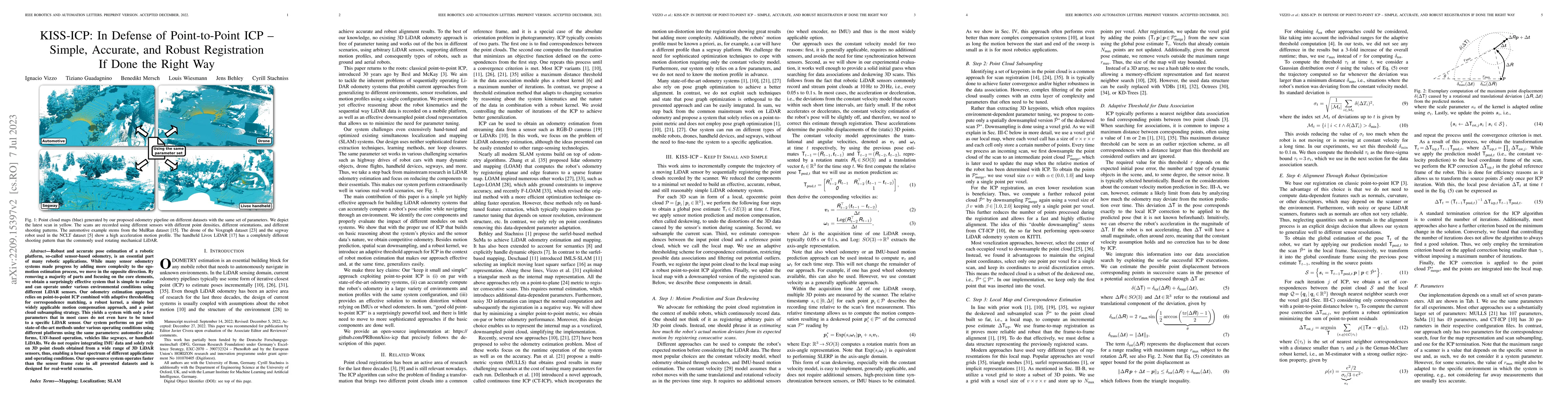
Robust and accurate pose estimation of a robotic platform, so-called sensor-based odometry, is an essential part of many robotic applications. While many sensor odometry systems made progress by add...
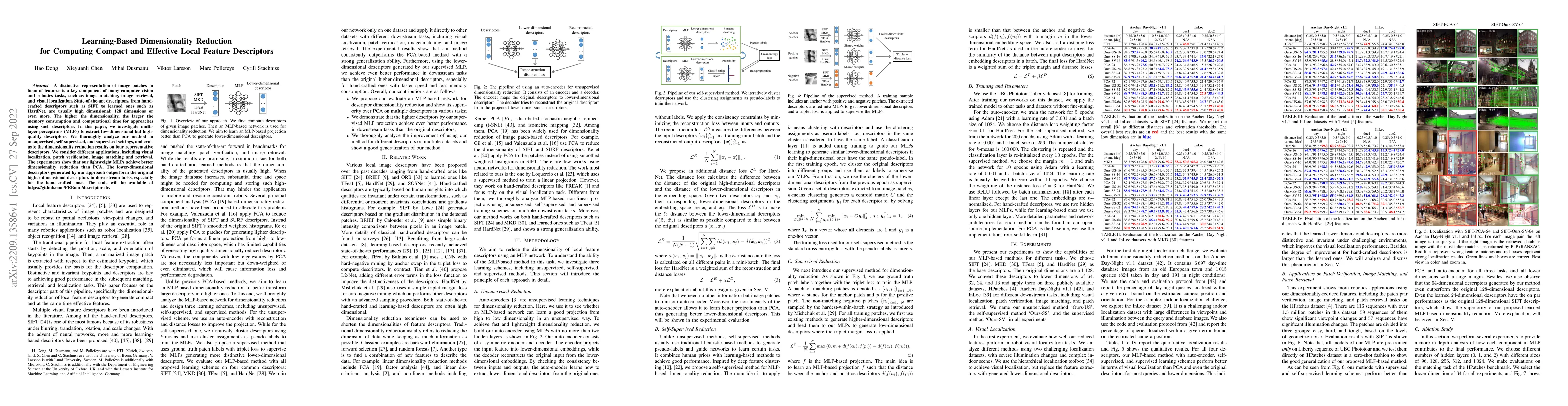
A distinctive representation of image patches in form of features is a key component of many computer vision and robotics tasks, such as image matching, image retrieval, and visual localization. Sta...
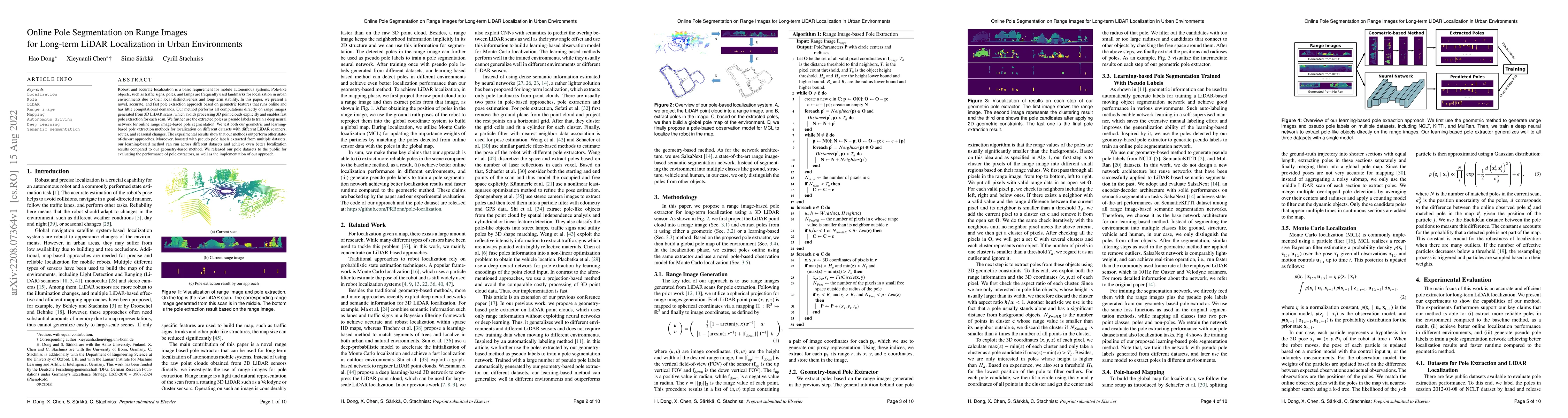
Robust and accurate localization is a basic requirement for mobile autonomous systems. Pole-like objects, such as traffic signs, poles, and lamps are frequently used landmarks for localization in ur...
A key challenge for autonomous vehicles is to navigate in unseen dynamic environments. Separating moving objects from static ones is essential for navigation, pose estimation, and understanding how ...
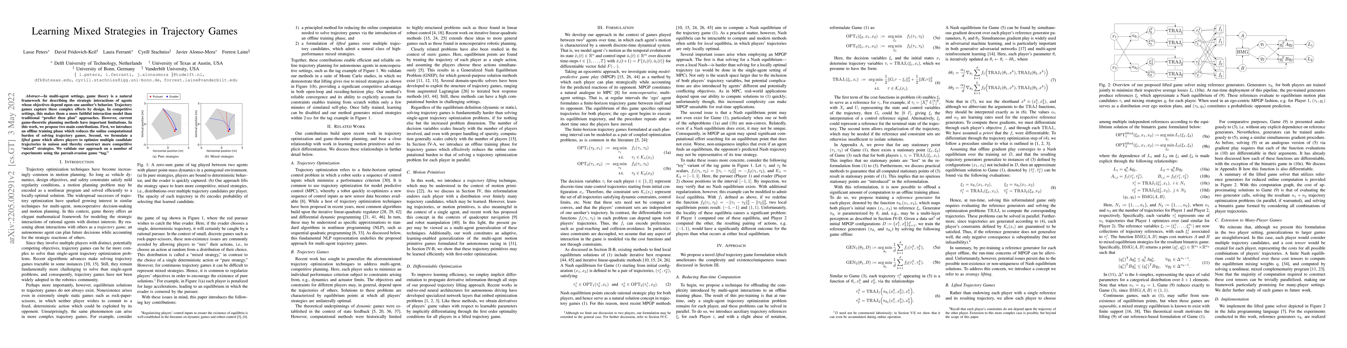
In multi-agent settings, game theory is a natural framework for describing the strategic interactions of agents whose objectives depend upon one another's behavior. Trajectory games capture these co...
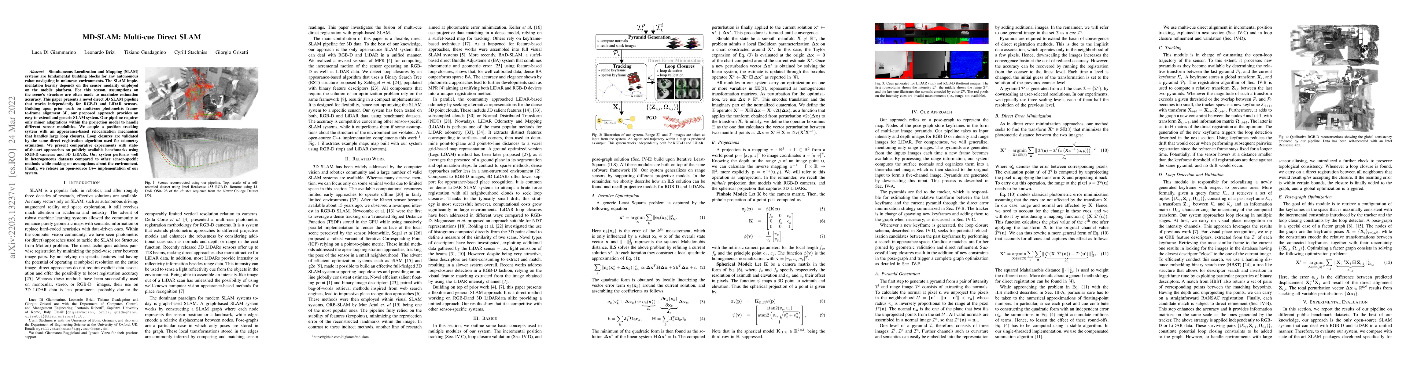
Simultaneous Localization and Mapping (SLAM) systems are fundamental building blocks for any autonomous robot navigating in unknown environments. The SLAM implementation heavily depends on the senso...
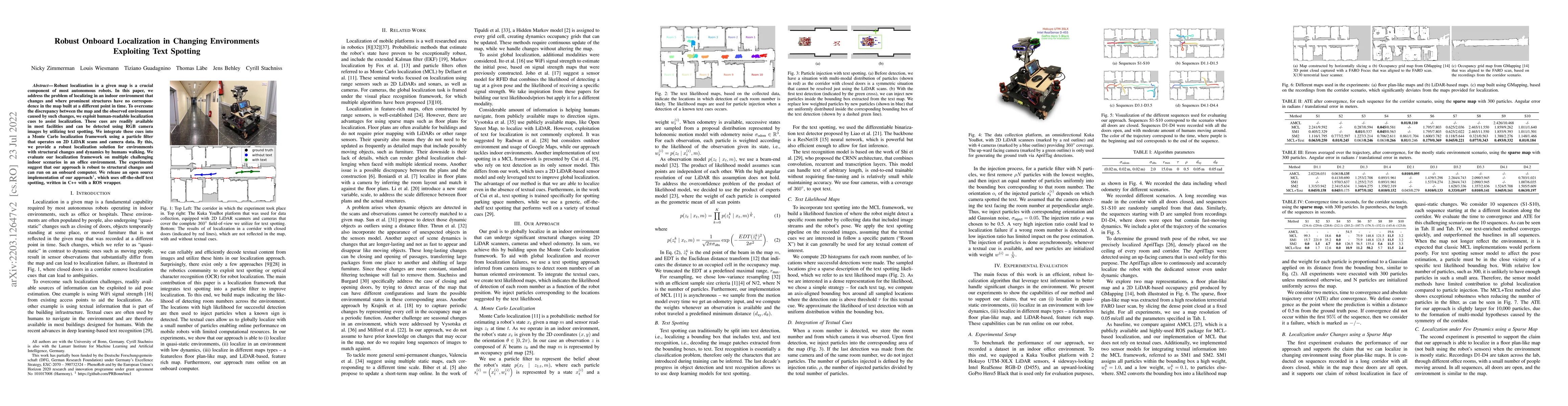
Robust localization in a given map is a crucial component of most autonomous robots. In this paper, we address the problem of localizing in an indoor environment that changes and where prominent str...
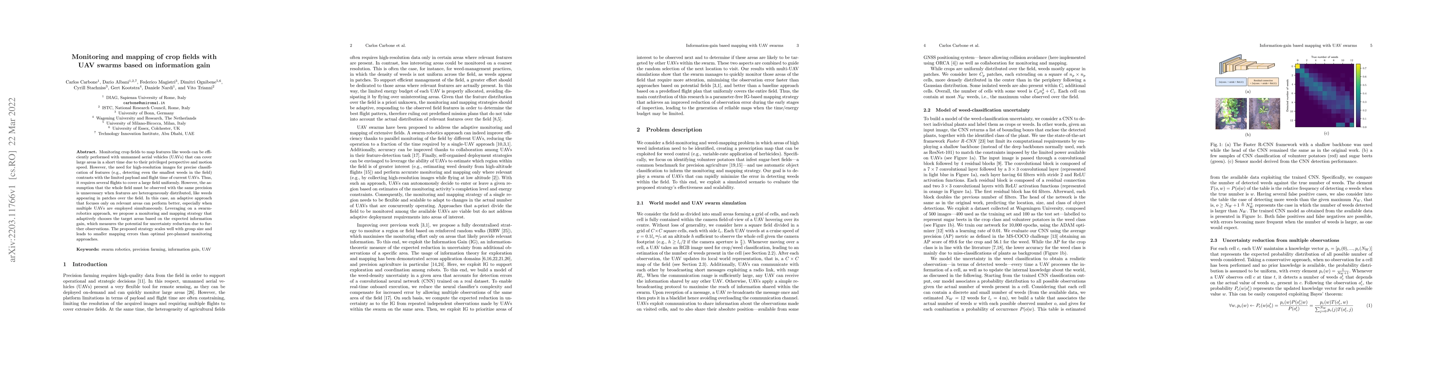
Monitoring crop fields to map features like weeds can be efficiently performed with unmanned aerial vehicles (UAVs) that can cover large areas in a short time due to their privileged perspective and...
Semantic segmentation of aerial imagery is an important tool for mapping and earth observation. However, supervised deep learning models for segmentation rely on large amounts of high-quality labell...
Efficient data collection methods play a major role in helping us better understand the Earth and its ecosystems. In many applications, the usage of unmanned aerial vehicles (UAVs) for monitoring an...
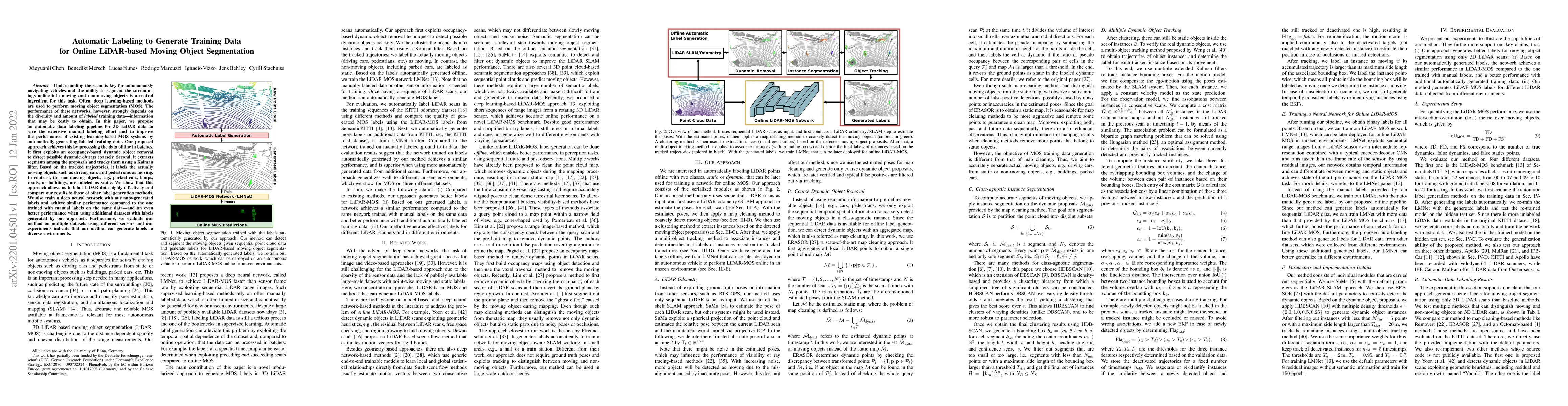
Understanding the scene is key for autonomously navigating vehicles and the ability to segment the surroundings online into moving and non-moving objects is a central ingredient for this task. Often...
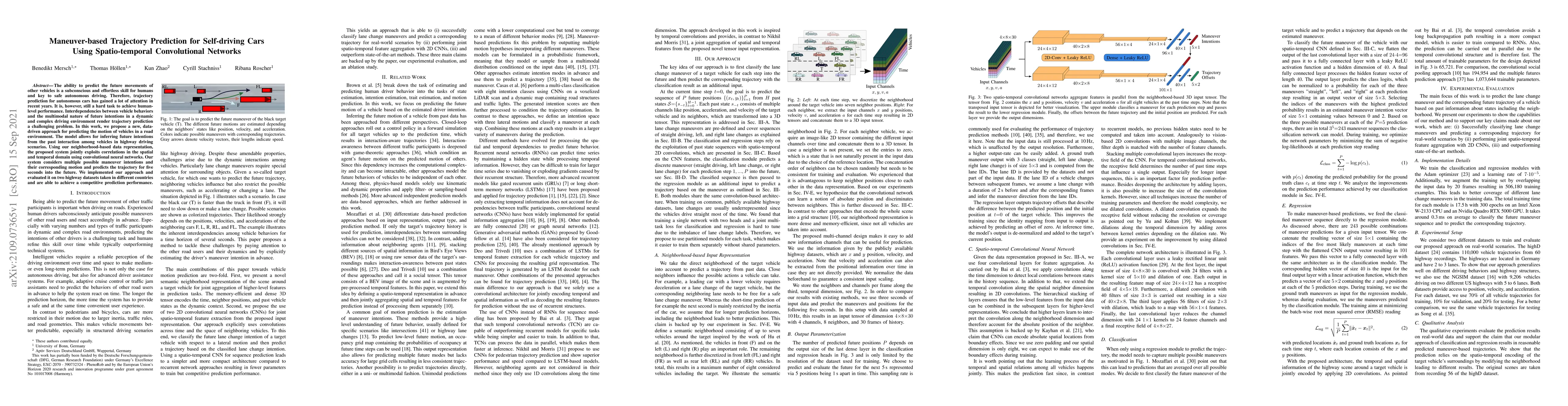
The ability to predict the future movements of other vehicles is a subconscious and effortless skill for humans and key to safe autonomous driving. Therefore, trajectory prediction for autonomous ca...
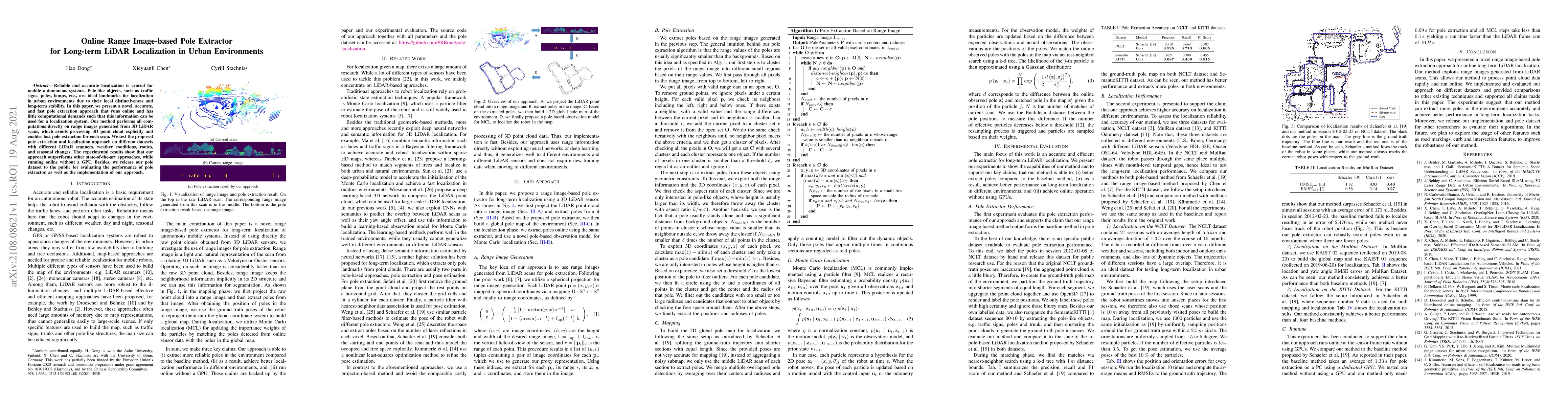
Reliable and accurate localization is crucial for mobile autonomous systems. Pole-like objects, such as traffic signs, poles, lamps, etc., are ideal landmarks for localization in urban environments ...
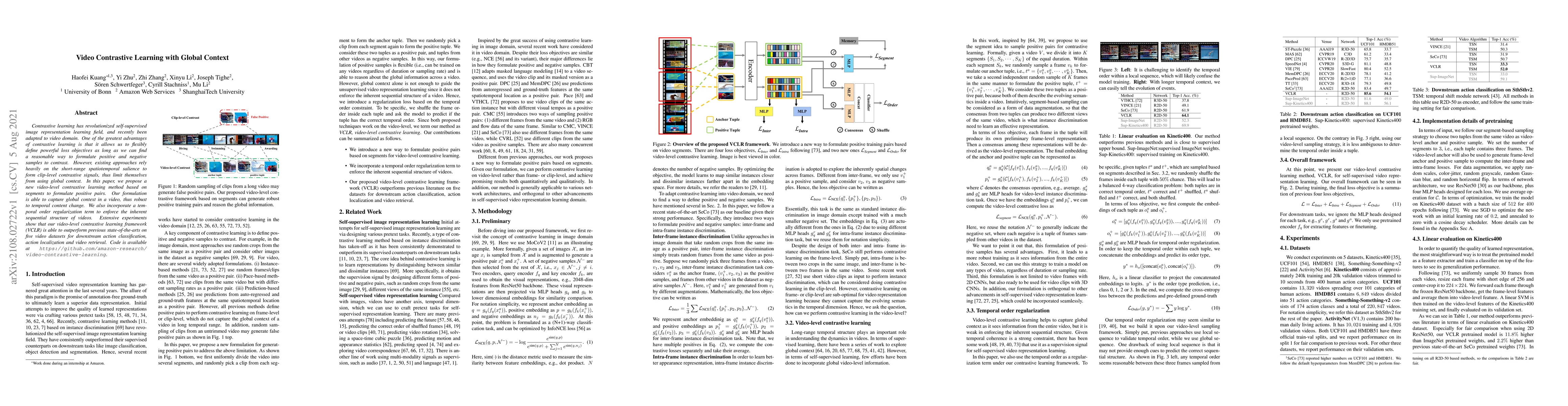
Contrastive learning has revolutionized self-supervised image representation learning field, and recently been adapted to video domain. One of the greatest advantages of contrastive learning is that...
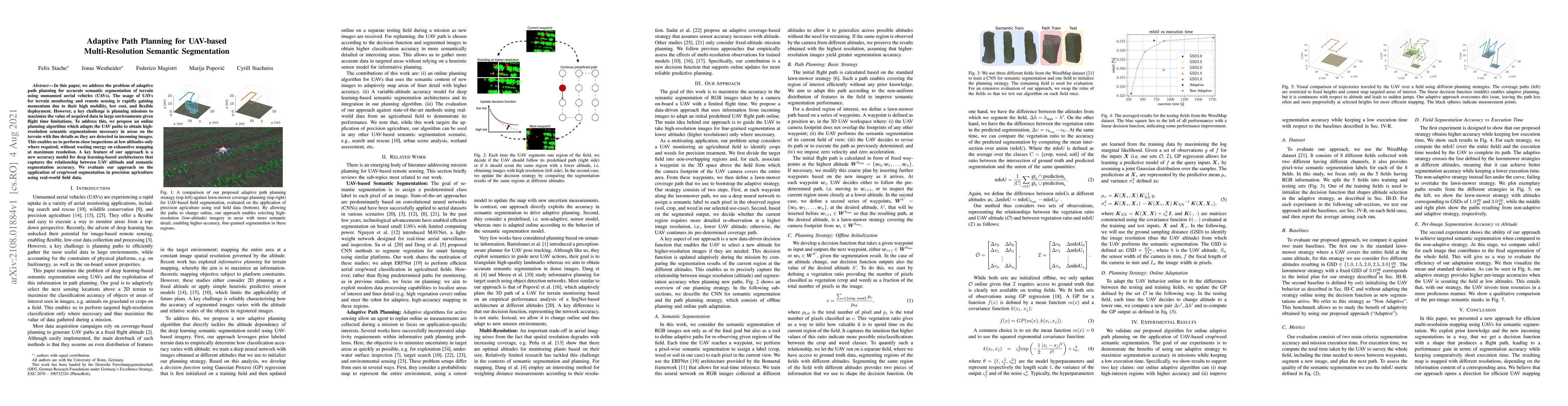
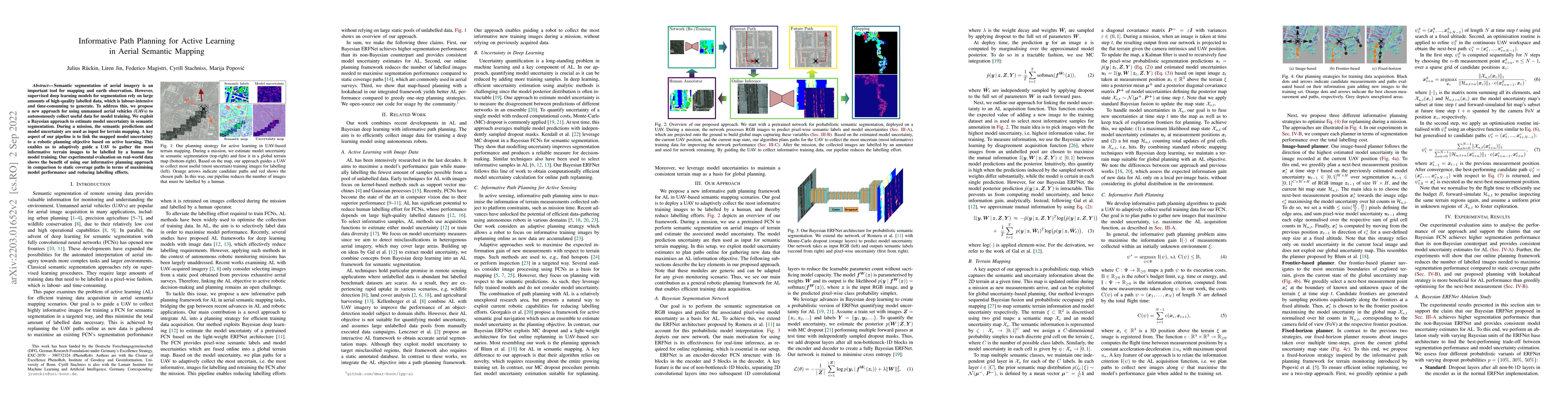
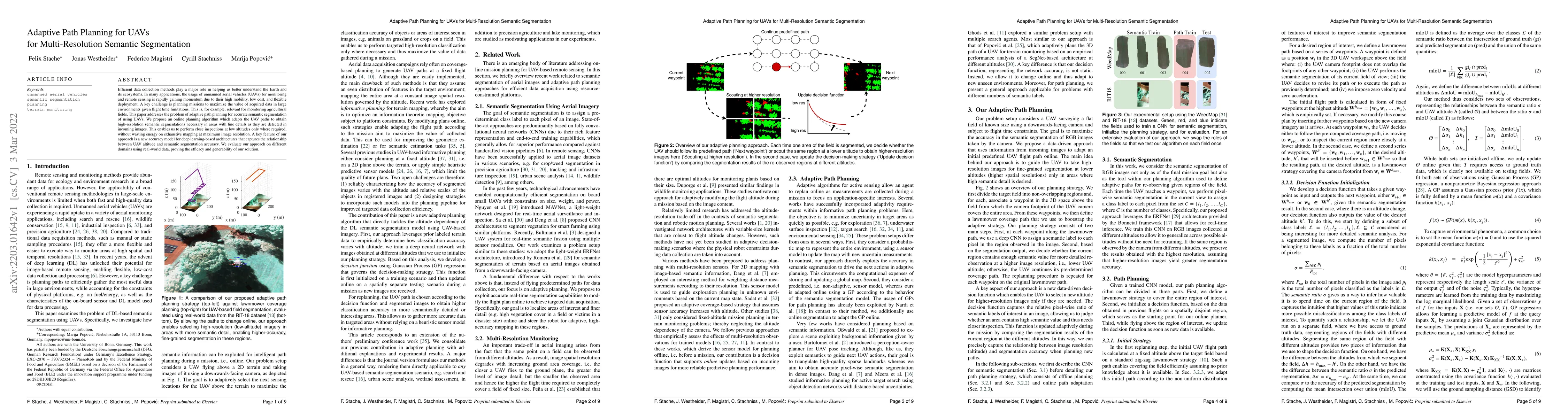
In this paper, we address the problem of adaptive path planning for accurate semantic segmentation of terrain using unmanned aerial vehicles (UAVs). The usage of UAVs for terrain monitoring and remo...
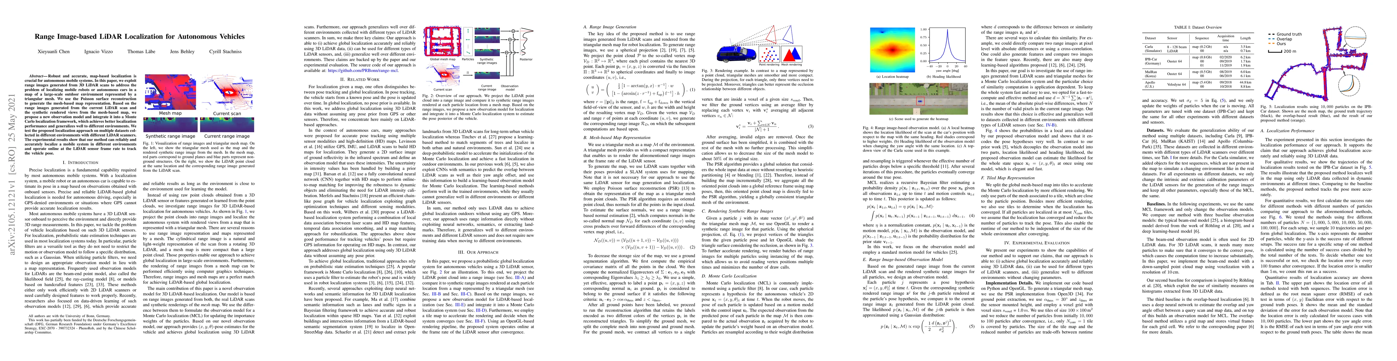
Robust and accurate, map-based localization is crucial for autonomous mobile systems. In this paper, we exploit range images generated from 3D LiDAR scans to address the problem of localizing mobile...
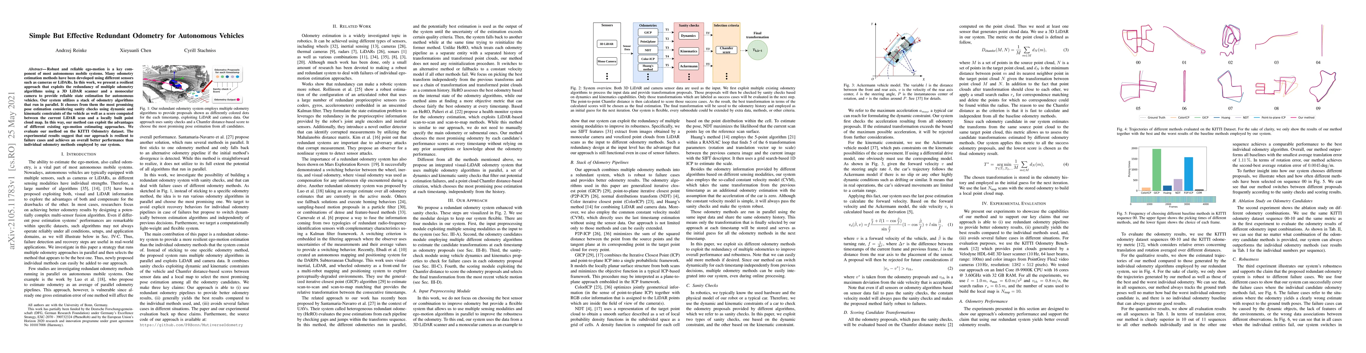
Robust and reliable ego-motion is a key component of most autonomous mobile systems. Many odometry estimation methods have been developed using different sensors such as cameras or LiDARs. In this w...
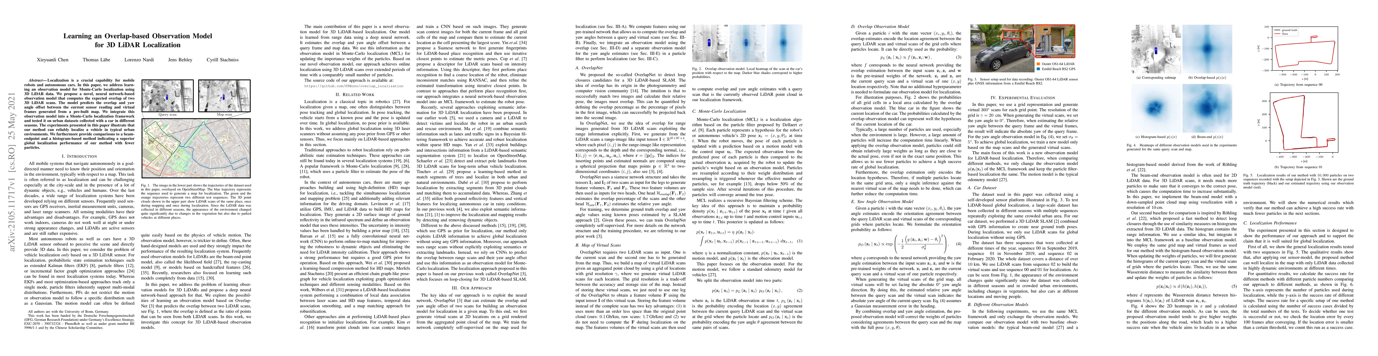
Localization is a crucial capability for mobile robots and autonomous cars. In this paper, we address learning an observation model for Monte-Carlo localization using 3D LiDAR data. We propose a nov...
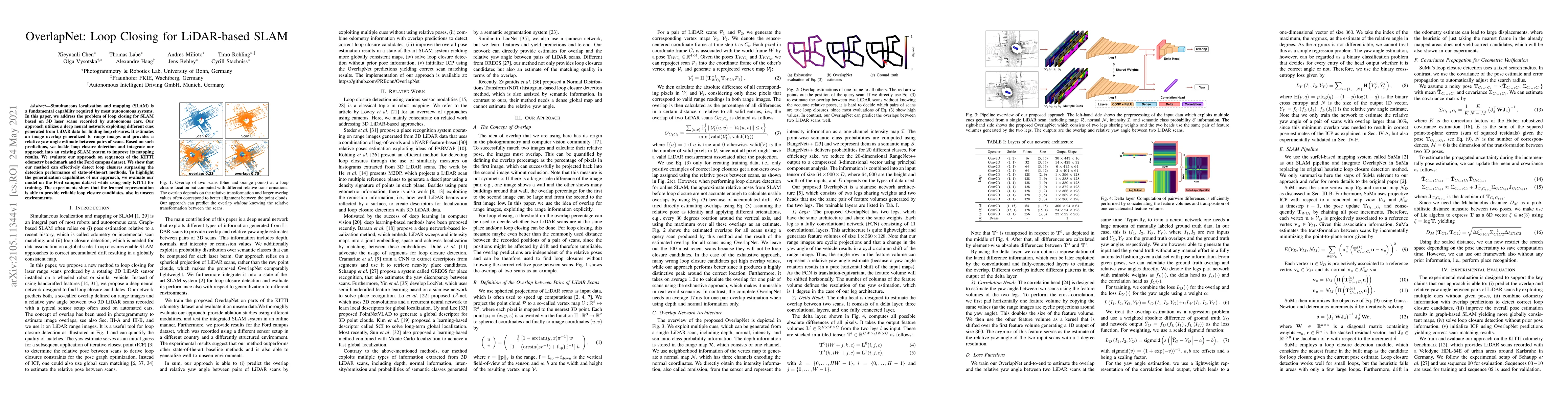
Simultaneous localization and mapping (SLAM) is a fundamental capability required by most autonomous systems. In this paper, we address the problem of loop closing for SLAM based on 3D laser scans r...
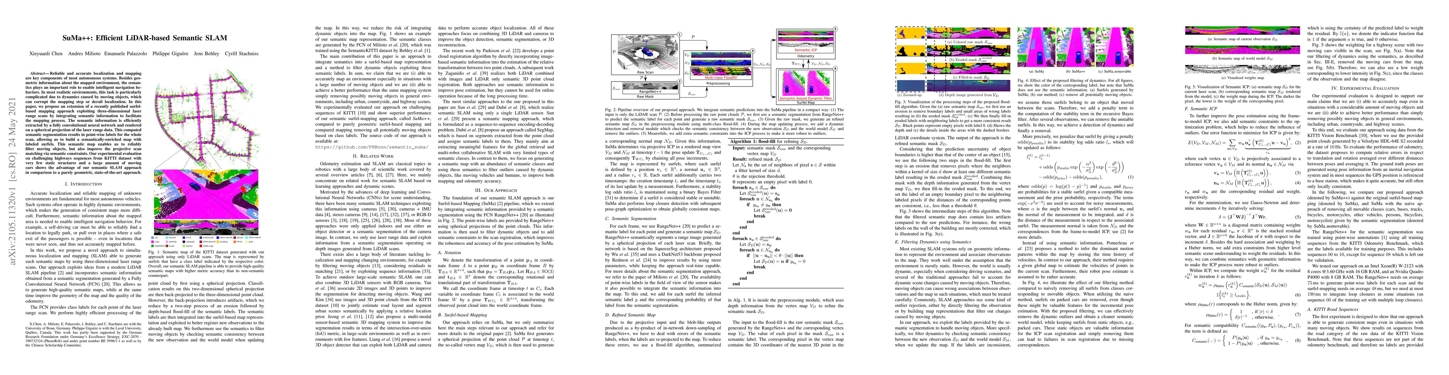
Reliable and accurate localization and mapping are key components of most autonomous systems. Besides geometric information about the mapped environment, the semantics plays an important role to ena...
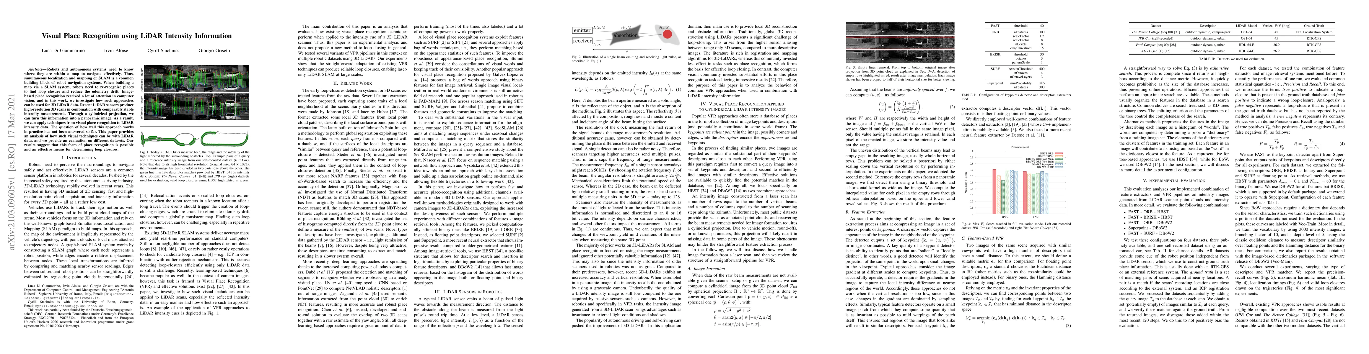
Robots and autonomous systems need to know where they are within a map to navigate effectively. Thus, simultaneous localization and mapping or SLAM is a common building block of robot navigation sys...
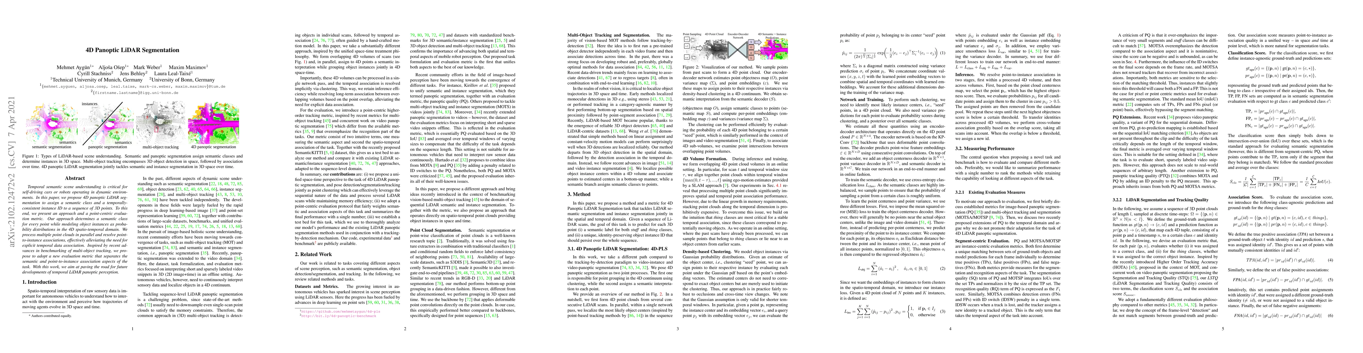
Temporal semantic scene understanding is critical for self-driving cars or robots operating in dynamic environments. In this paper, we propose 4D panoptic LiDAR segmentation to assign a semantic cla...
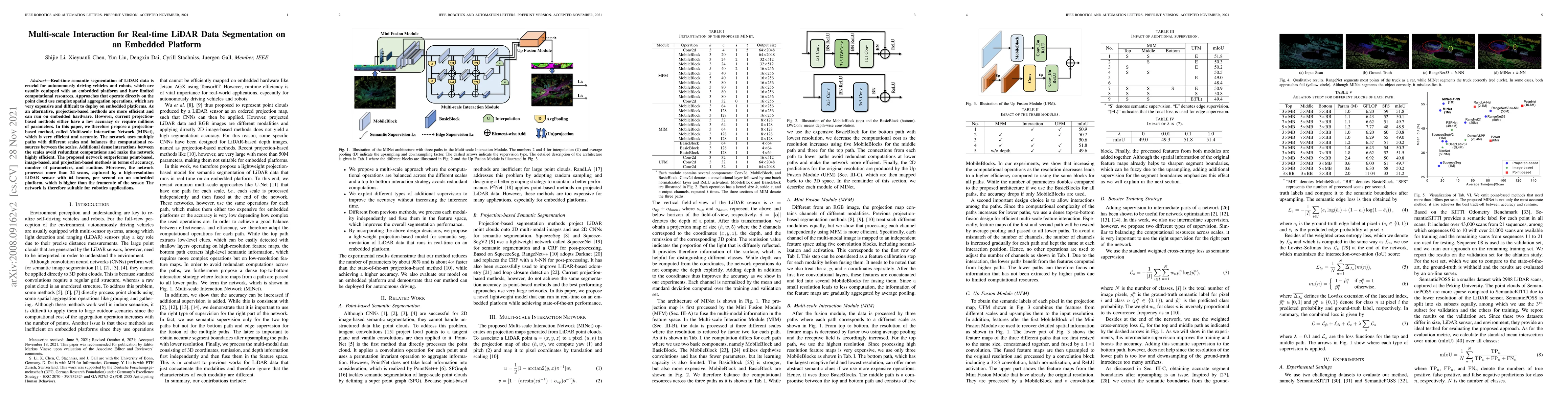
Real-time semantic segmentation of LiDAR data is crucial for autonomously driving vehicles, which are usually equipped with an embedded platform and have limited computational resources. Approaches ...
State estimation is a key ingredient in most robotic systems. Often, state estimation is performed using some form of least squares minimization. Basically, all error minimization procedures that wo...
Pose estimation and map building are central ingredients of autonomous robots and typically rely on the registration of sensor data. In this paper, we investigate a new metric for registering images...
Panoptic segmentation is the recently introduced task that tackles semantic segmentation and instance segmentation jointly. In this paper, we present an extension of SemanticKITTI, which is a large-...
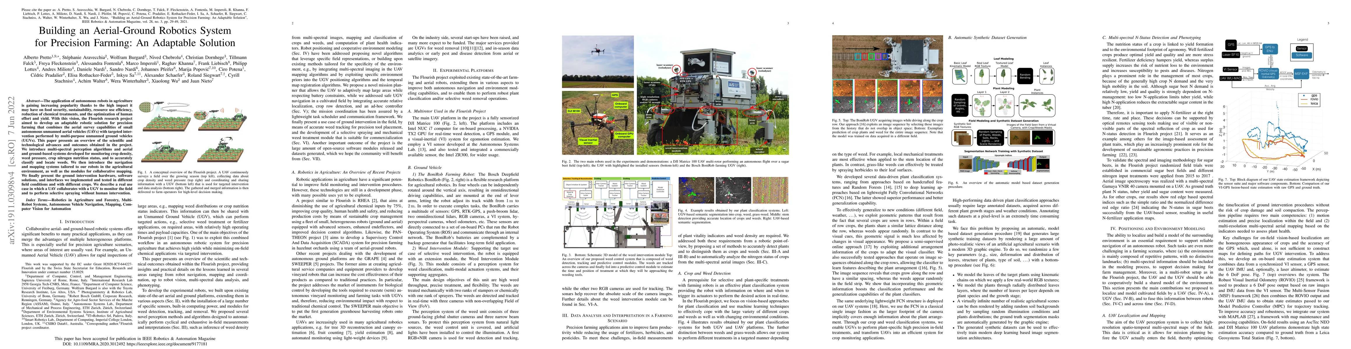
The application of autonomous robots in agriculture is gaining increasing popularity thanks to the high impact it may have on food security, sustainability, resource use efficiency, reduction of che...
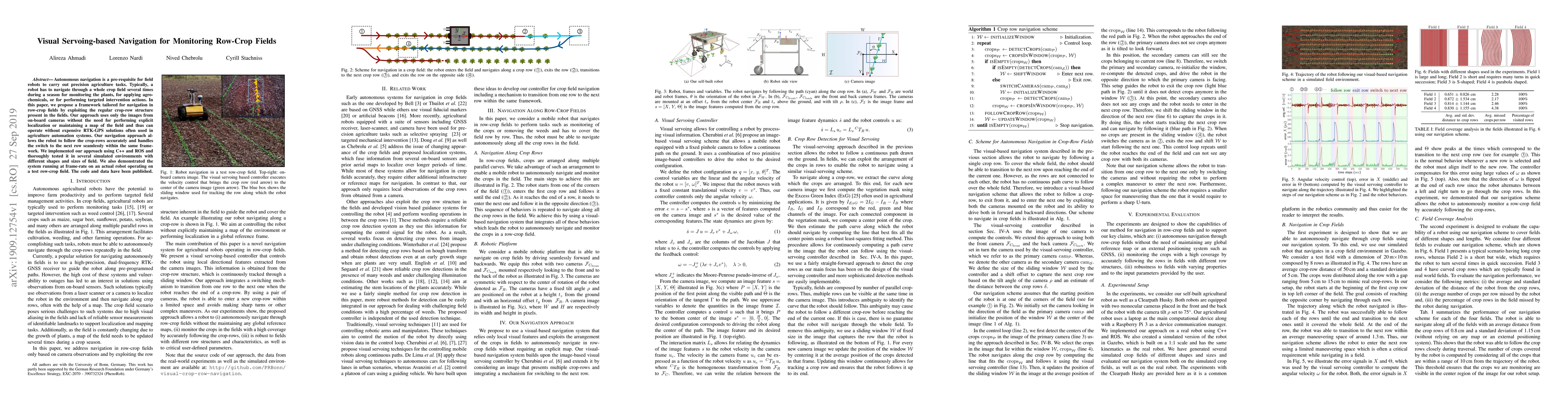
Autonomous navigation is a pre-requisite for field robots to carry out precision agriculture tasks. Typically, a robot has to navigate through a whole crop field several times during a season for mo...
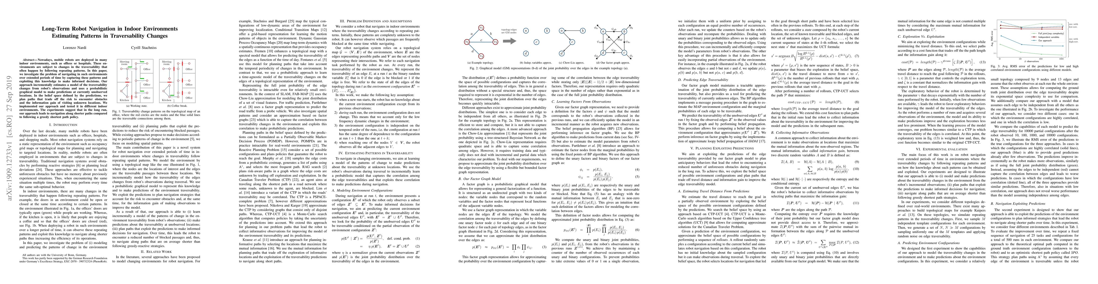
Nowadays, mobile robots are deployed in many indoor environments, such as offices or hospitals. These environments are subject to changes in the traversability that often happen by following repeati...
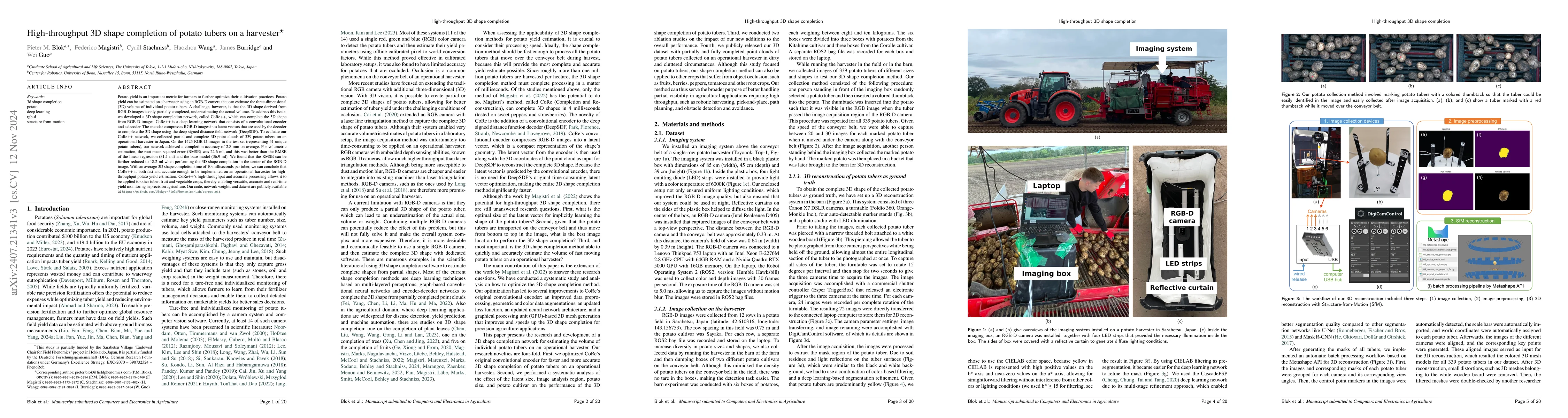
Potato yield is an important metric for farmers to further optimize their cultivation practices. Potato yield can be estimated on a harvester using an RGB-D camera that can estimate the three-dimensio...
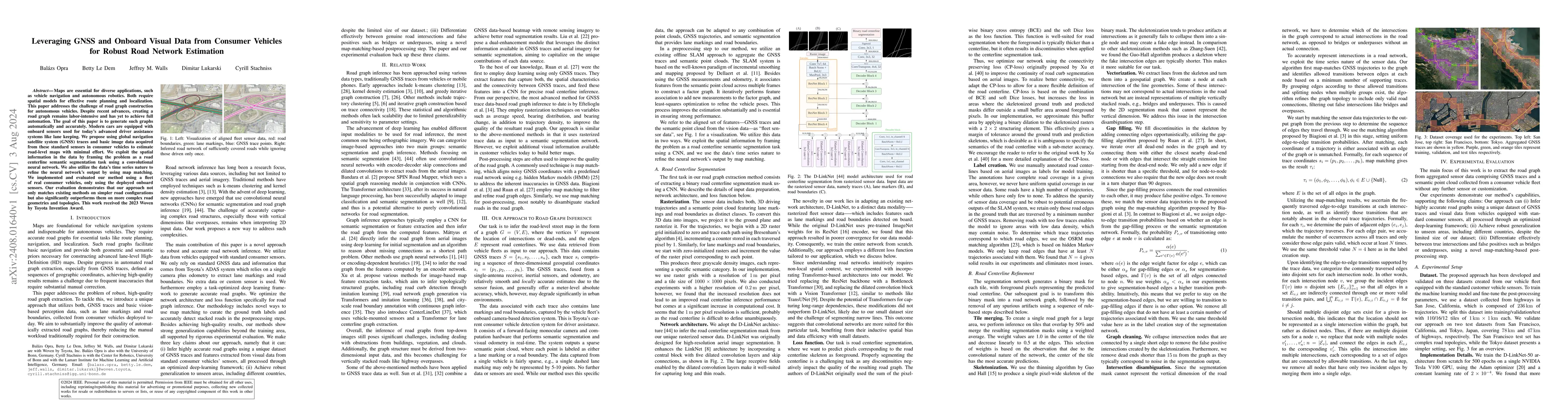
Maps are essential for diverse applications, such as vehicle navigation and autonomous robotics. Both require spatial models for effective route planning and localization. This paper addresses the cha...
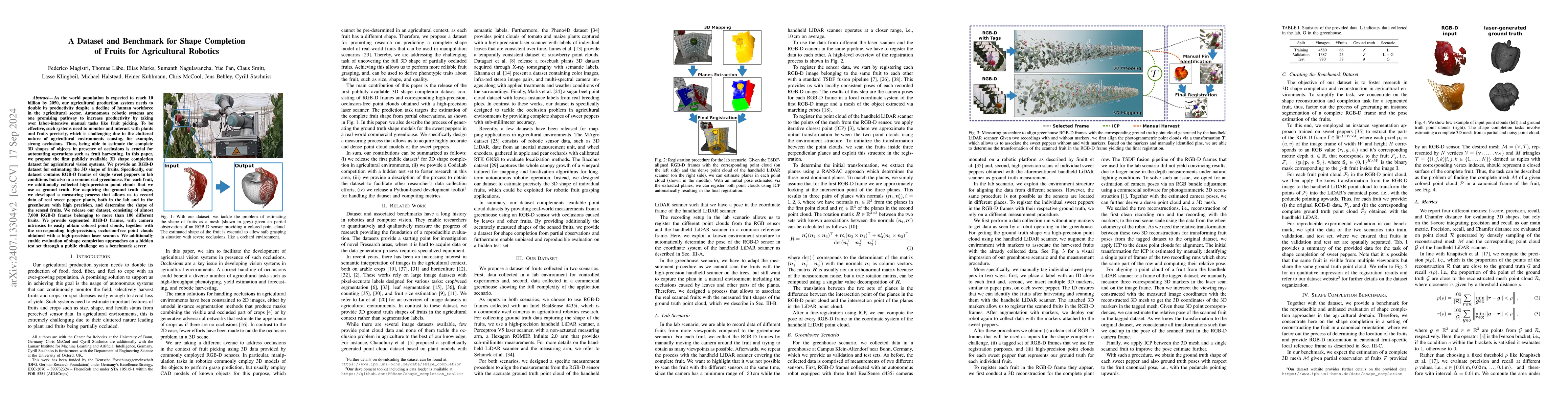
As the population is expected to reach 10 billion by 2050, our agricultural production system needs to double its productivity despite a decline of human workforce in the agricultural sector. Autonomo...
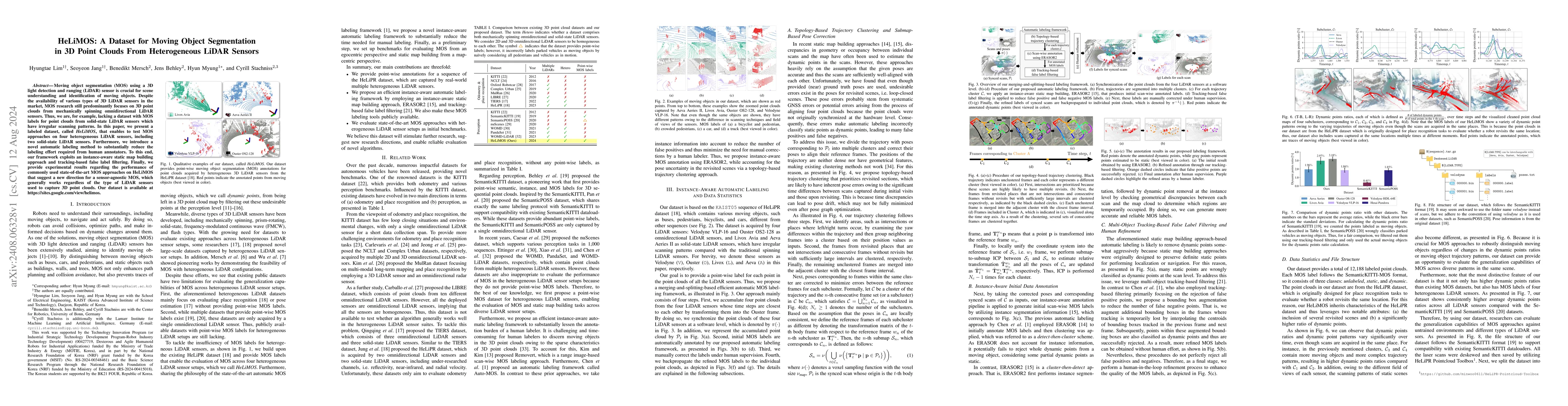
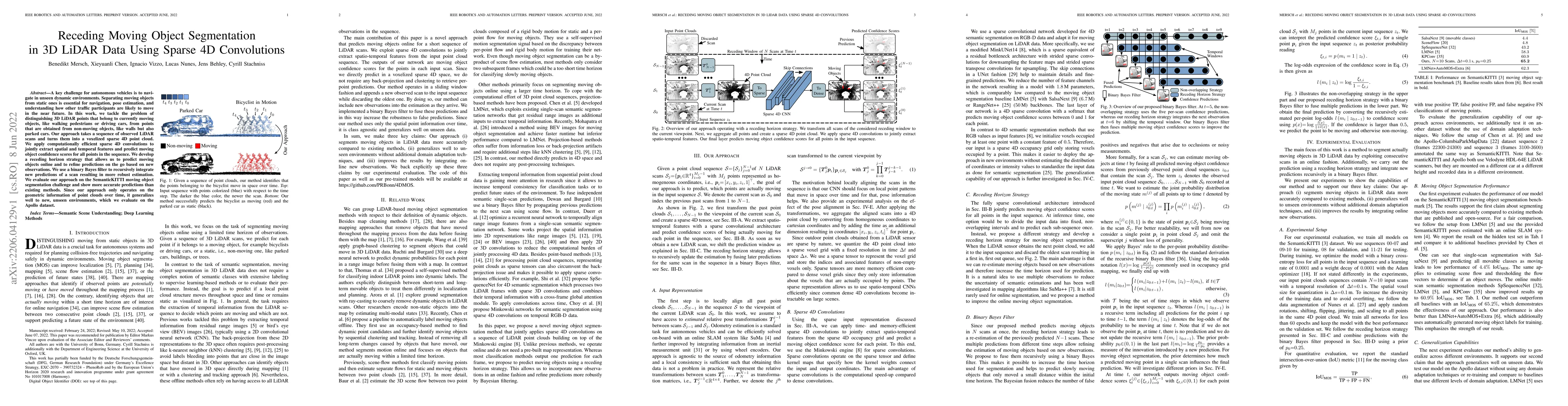
Moving object segmentation (MOS) using a 3D light detection and ranging (LiDAR) sensor is crucial for scene understanding and identification of moving objects. Despite the availability of various type...
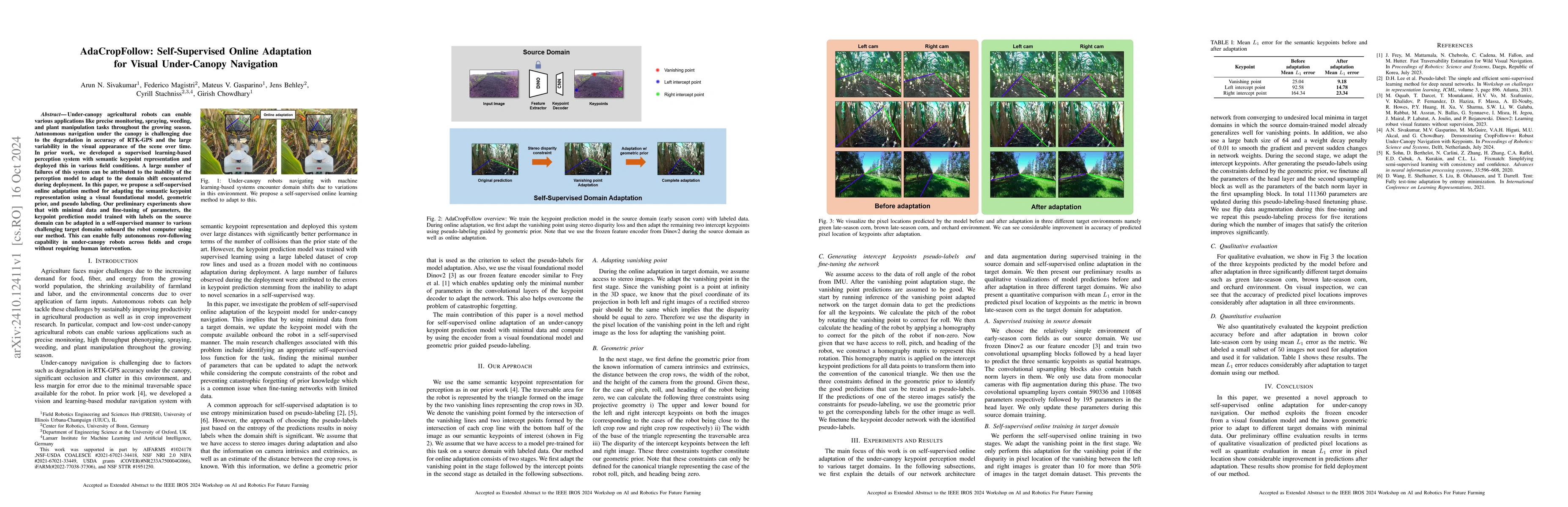
Under-canopy agricultural robots can enable various applications like precise monitoring, spraying, weeding, and plant manipulation tasks throughout the growing season. Autonomous navigation under the...
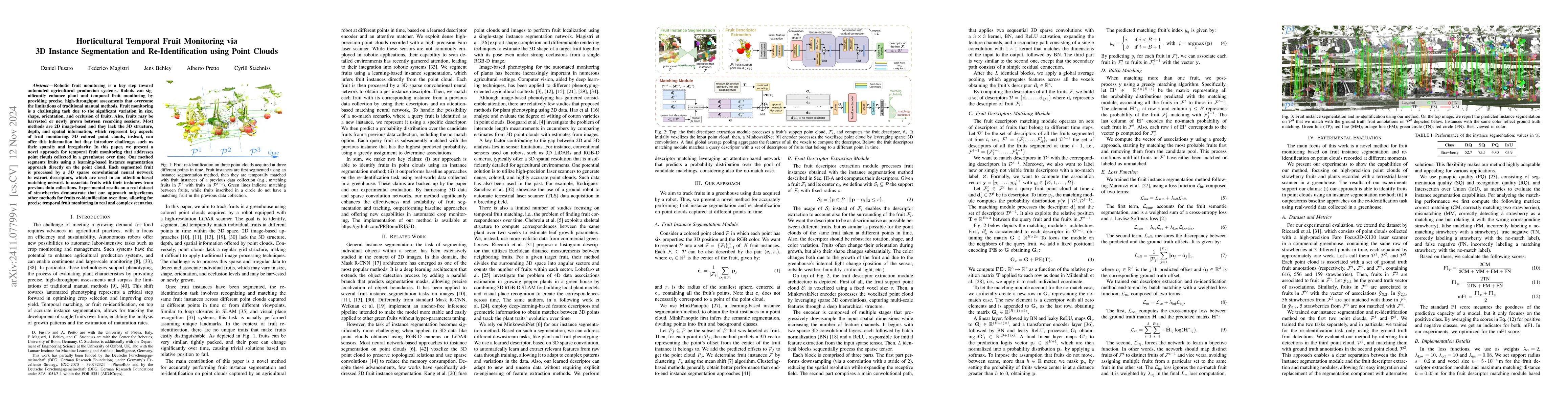
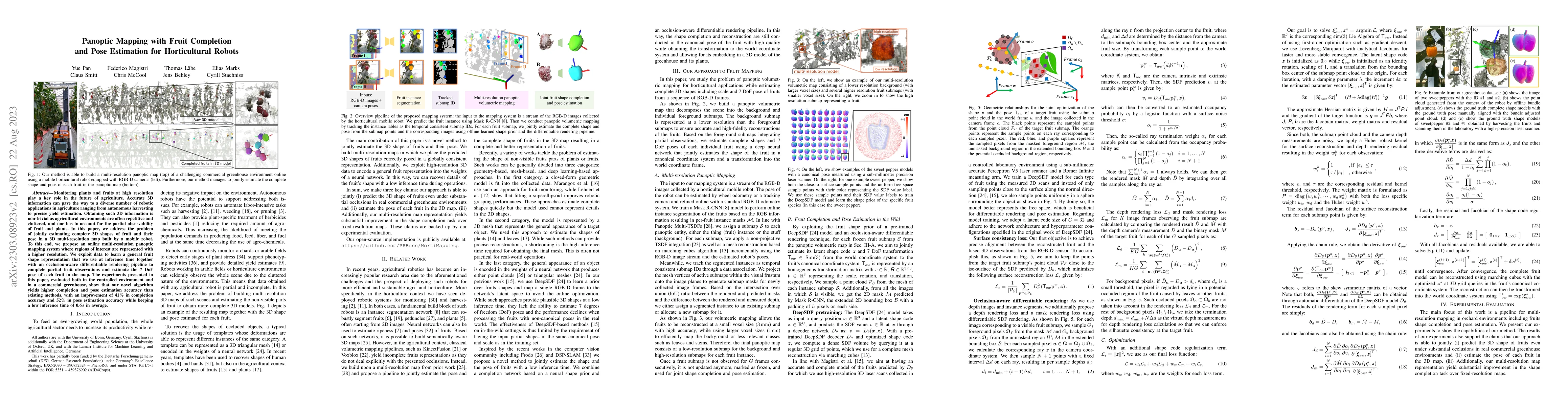
Robotic fruit monitoring is a key step toward automated agricultural production systems. Robots can significantly enhance plant and temporal fruit monitoring by providing precise, high-throughput asse...
Spatial understanding of the semantics of the surroundings is a key capability needed by autonomous cars to enable safe driving decisions. Recently, purely vision-based solutions have gained increasin...
Robots are frequently tasked to gather relevant sensor data in unknown terrains. A key challenge for classical path planning algorithms used for autonomous information gathering is adaptively replanni...
Robots need robust and flexible vision systems to perceive and reason about their environments beyond geometry. Most of such systems build upon deep learning approaches. As autonomous robots are commo...
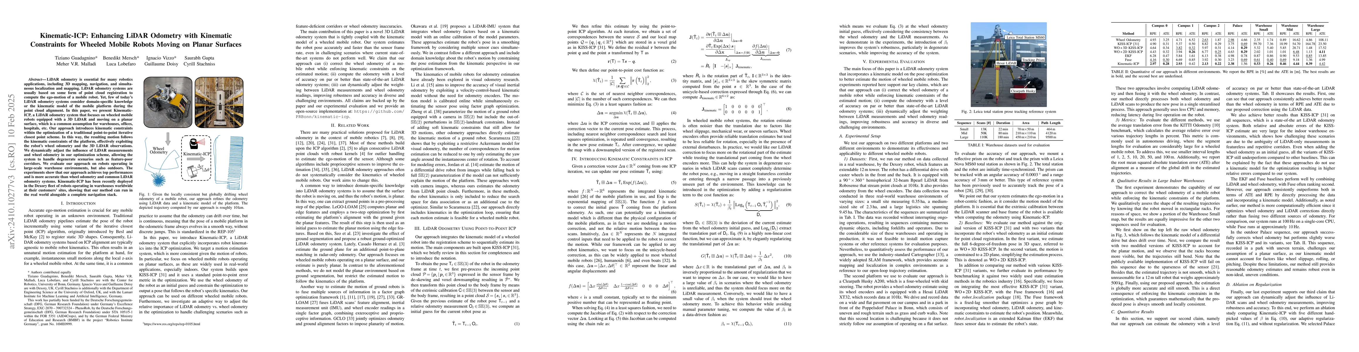
LiDAR odometry is essential for many robotics applications, including 3D mapping, navigation, and simultaneous localization and mapping. LiDAR odometry systems are usually based on some form of point ...
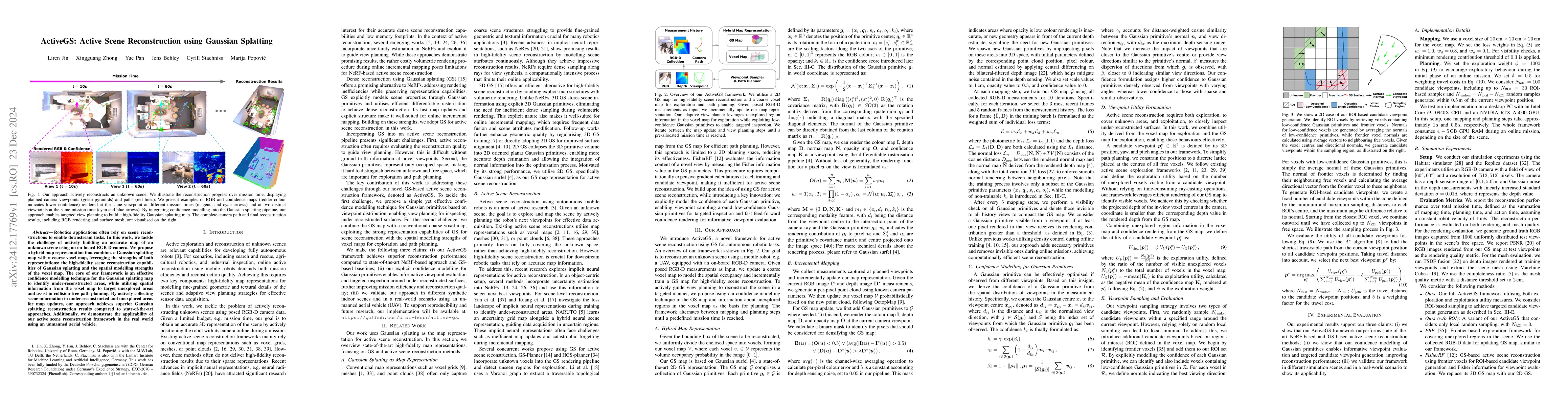
Robotics applications often rely on scene reconstructions to enable downstream tasks. In this work, we tackle the challenge of actively building an accurate map of an unknown scene using an on-board R...
Perception is a key building block of autonomously acting vision systems such as autonomous vehicles. It is crucial that these systems are able to understand their surroundings in order to operate saf...
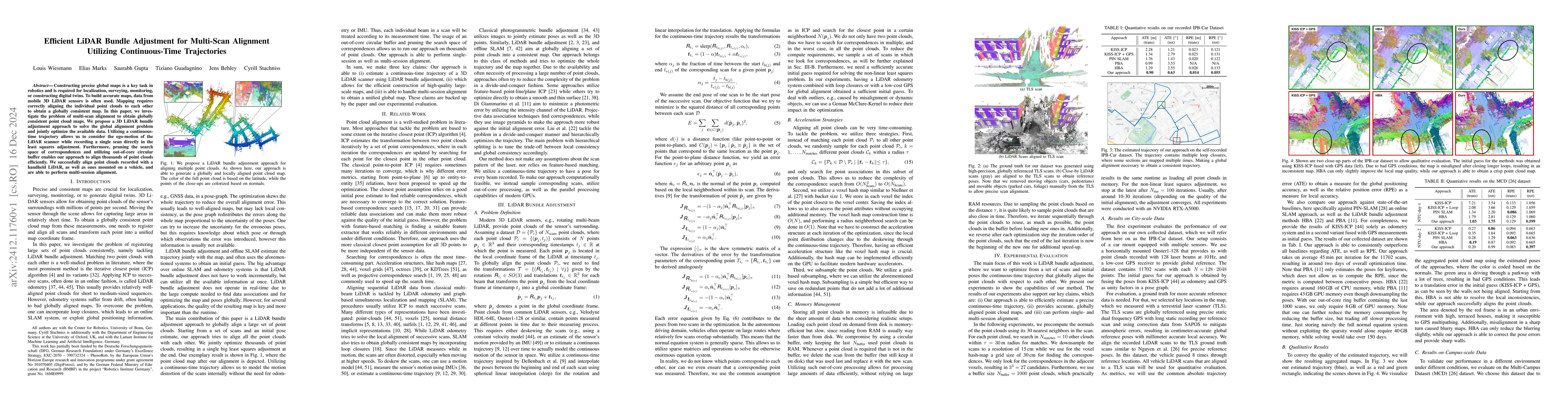
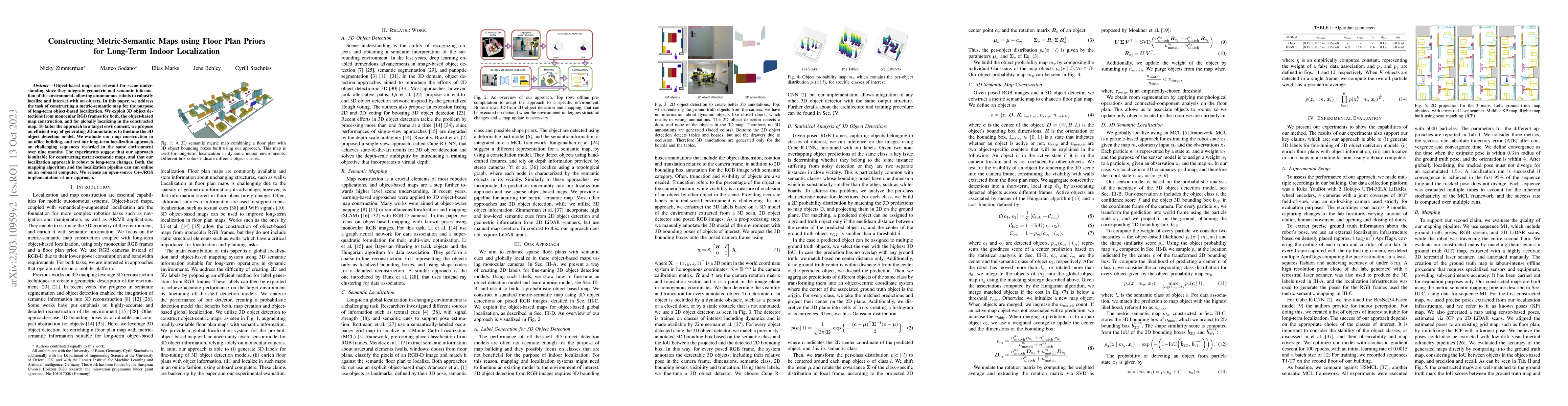
Constructing precise global maps is a key task in robotics and is required for localization, surveying, monitoring, or constructing digital twins. To build accurate maps, data from mobile 3D LiDAR sen...
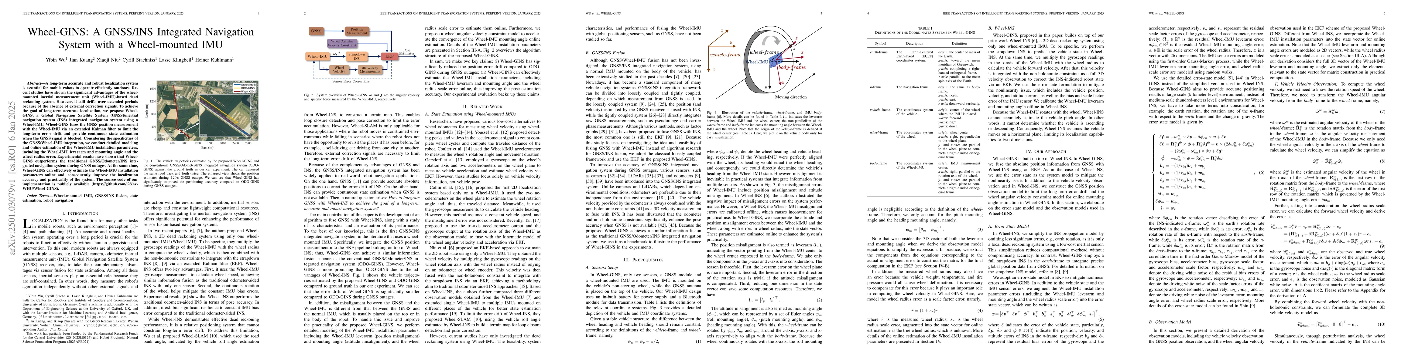
A long-term accurate and robust localization system is essential for mobile robots to operate efficiently outdoors. Recent studies have shown the significant advantages of the wheel-mounted inertial m...
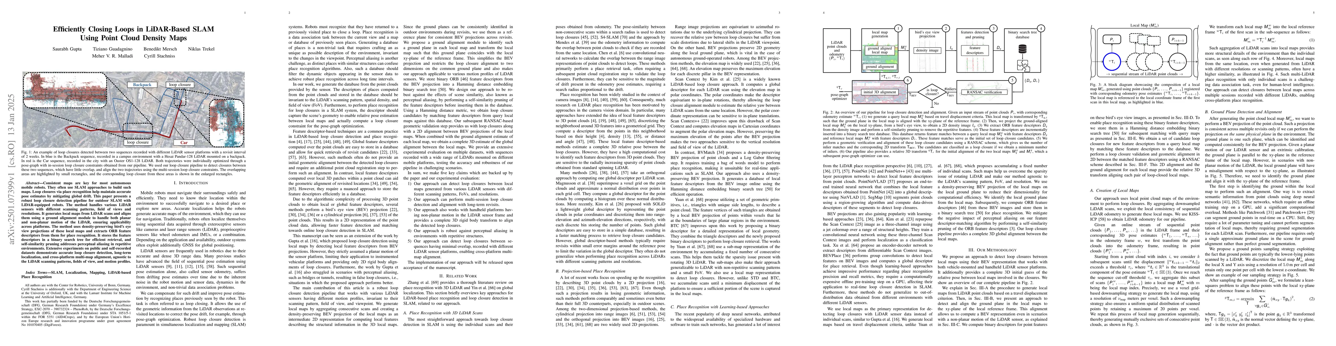
Consistent maps are key for most autonomous mobile robots. They often use SLAM approaches to build such maps. Loop closures via place recognition help maintain accurate pose estimates by mitigating gl...
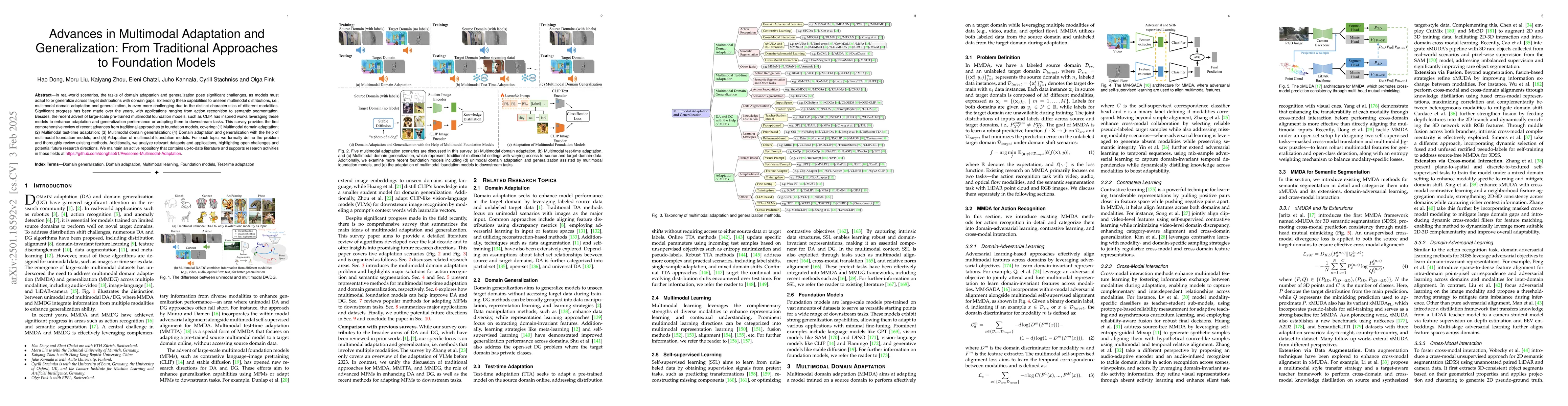
In real-world scenarios, achieving domain adaptation and generalization poses significant challenges, as models must adapt to or generalize across unknown target distributions. Extending these capabil...
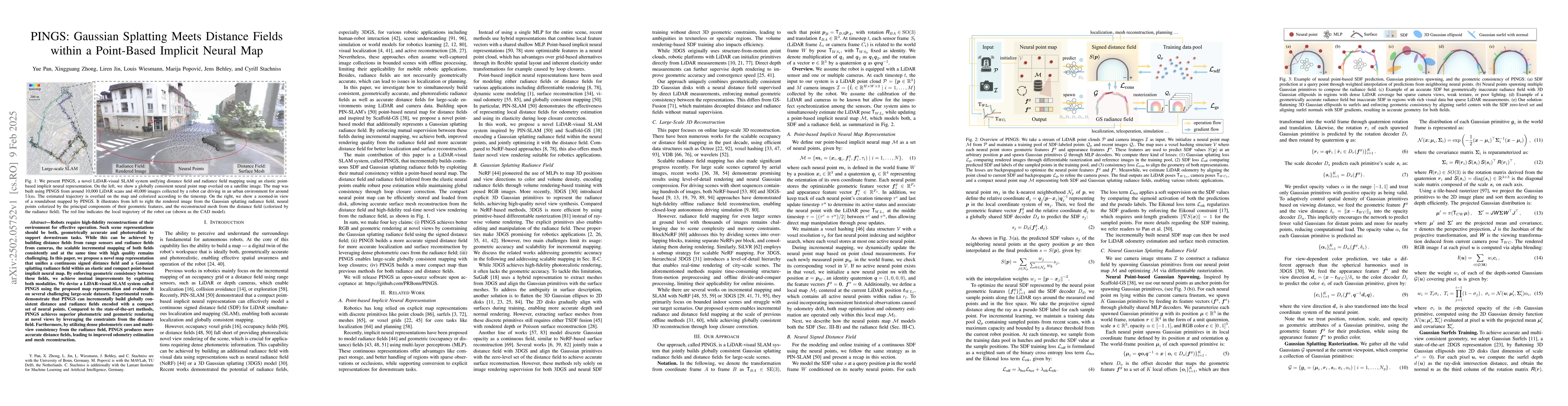
Robots require high-fidelity reconstructions of their environment for effective operation. Such scene representations should be both, geometrically accurate and photorealistic to support downstream ta...
Crop yield estimation is a relevant problem in agriculture, because an accurate crop yield estimate can support farmers' decisions on harvesting or precision intervention. Robots can help to automate ...
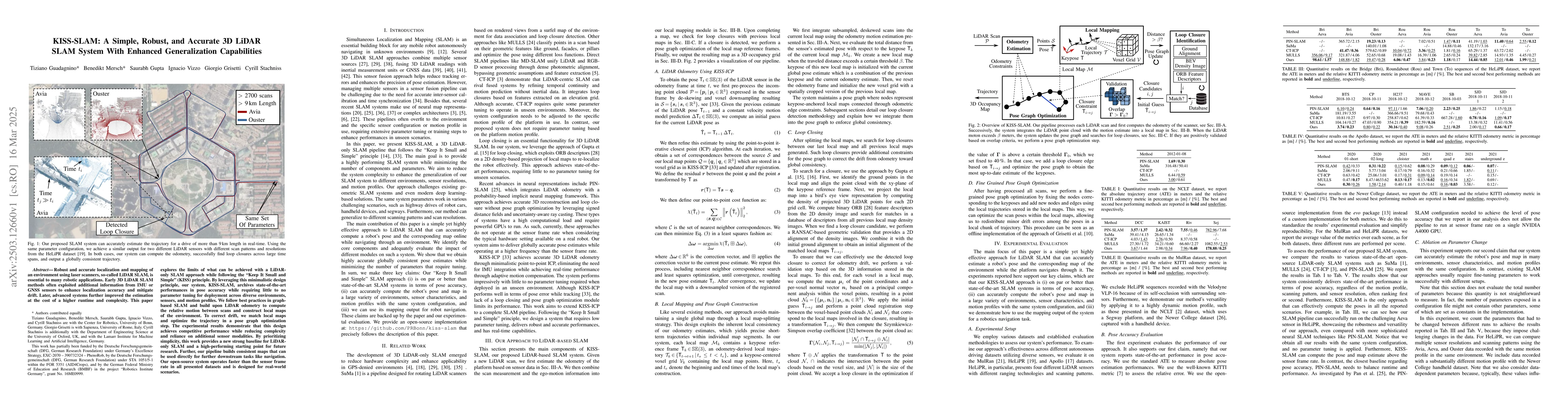
Robust and accurate localization and mapping of an environment using laser scanners, so-called LiDAR SLAM, is essential to many robotic applications. Early 3D LiDAR SLAM methods often exploited additi...
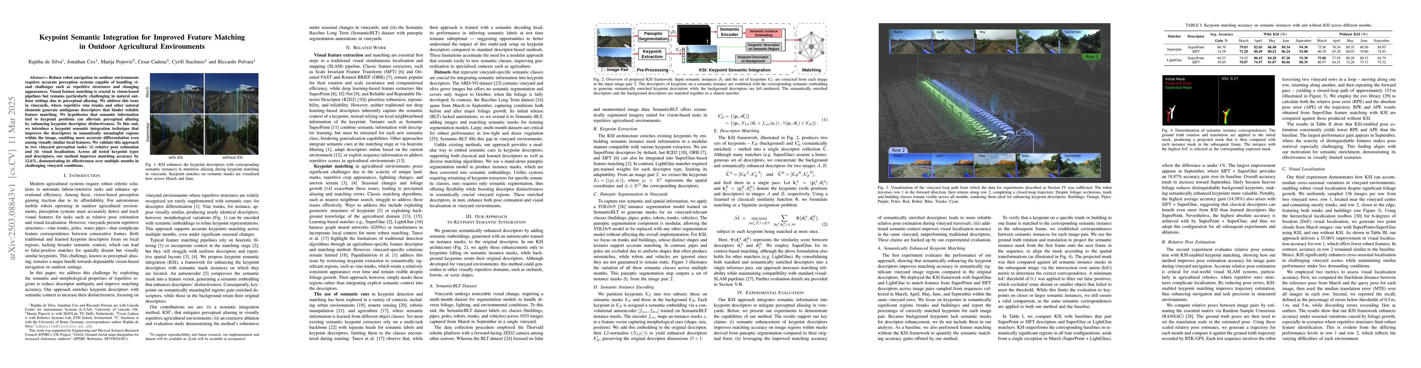
Robust robot navigation in outdoor environments requires accurate perception systems capable of handling visual challenges such as repetitive structures and changing appearances. Visual feature matchi...
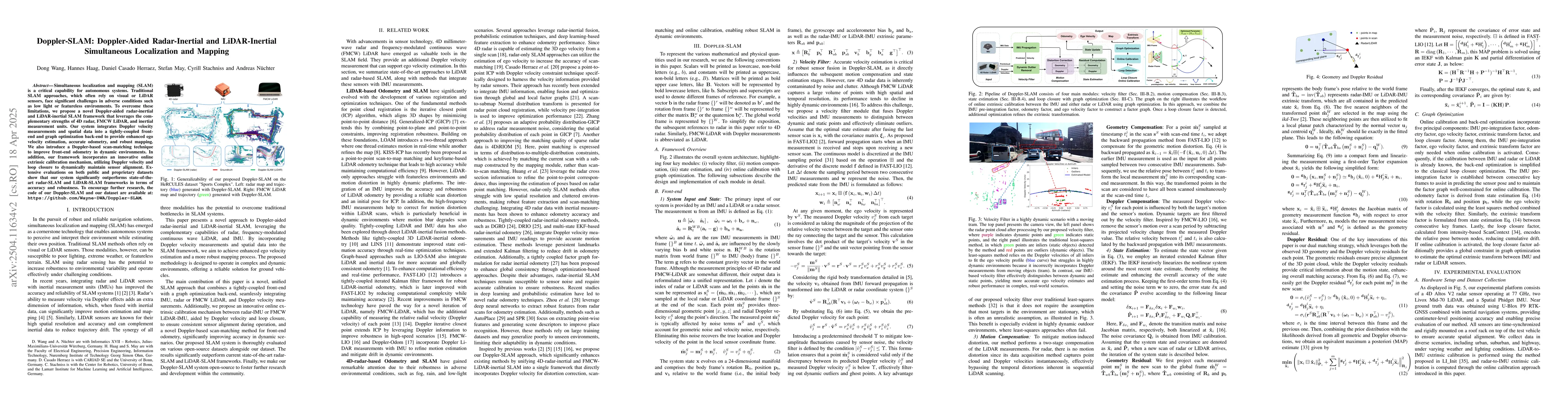
Simultaneous localization and mapping (SLAM) is a critical capability for autonomous systems. Traditional SLAM approaches, which often rely on visual or LiDAR sensors, face significant challenges in a...
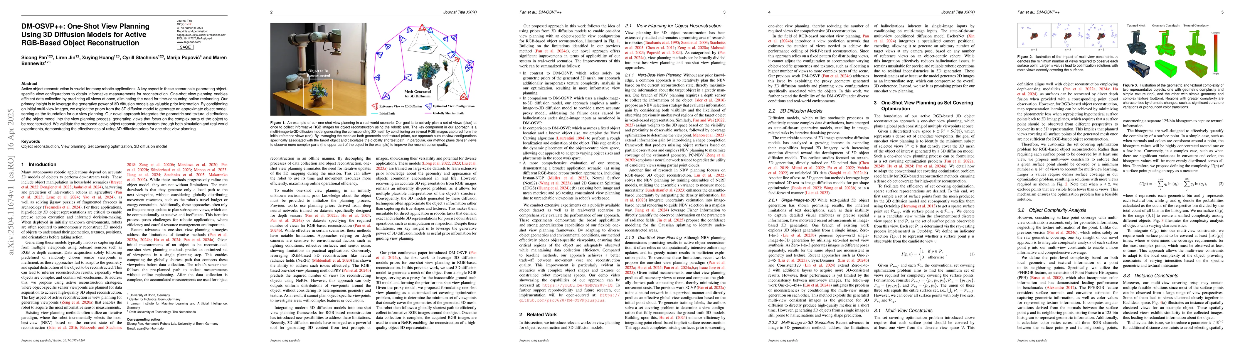
Active object reconstruction is crucial for many robotic applications. A key aspect in these scenarios is generating object-specific view configurations to obtain informative measurements for reconstr...
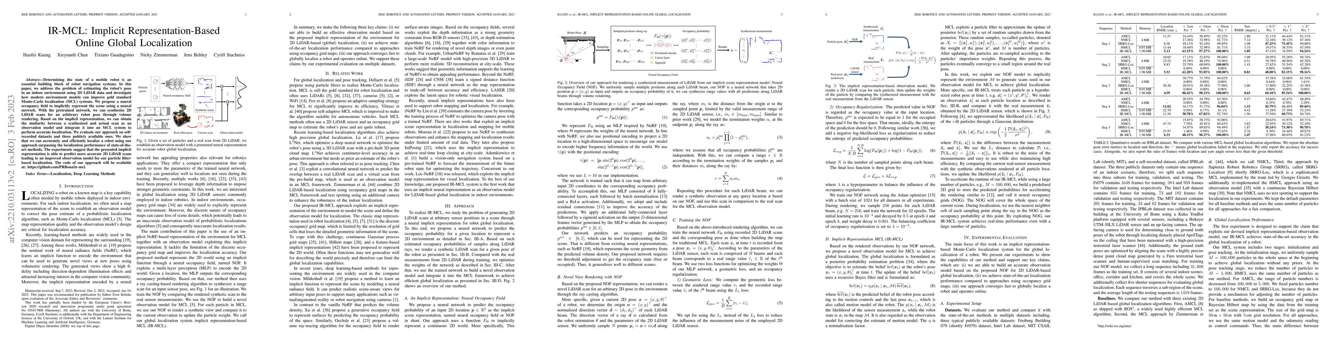
Globally localizing a mobile robot in a known map is often a foundation for enabling robots to navigate and operate autonomously. In indoor environments, traditional Monte Carlo localization based on ...
Recently, 3D Gaussian splatting-based RGB-D SLAM displays remarkable performance of high-fidelity 3D reconstruction. However, the lack of depth rendering consistency and efficient loop closure limits ...
Mobile robots exploring indoor environments increasingly rely on vision-language models to perceive high-level semantic cues in camera images, such as object categories. Such models offer the potentia...
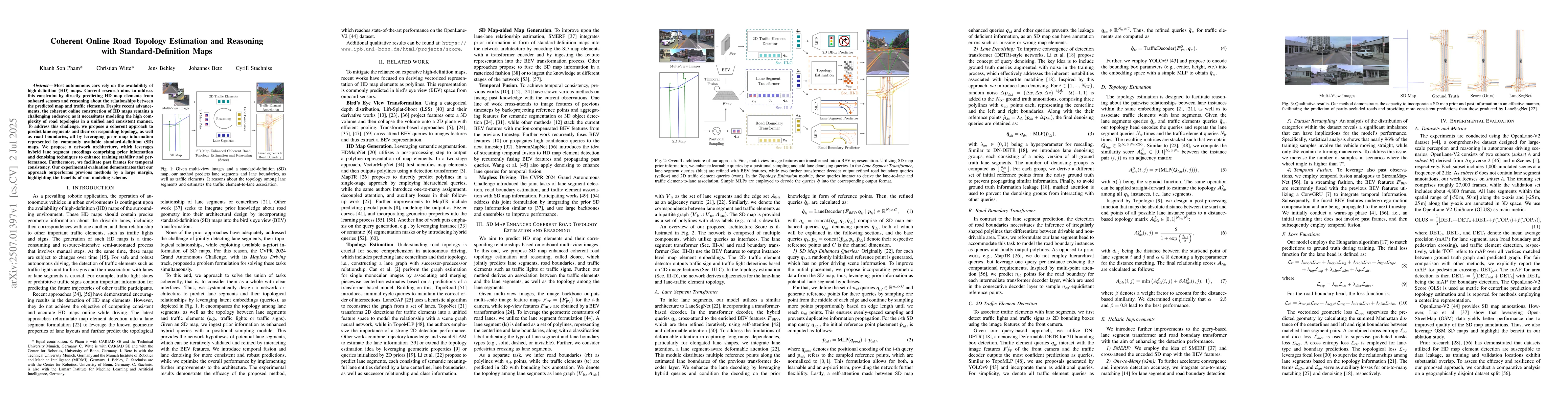
Most autonomous cars rely on the availability of high-definition (HD) maps. Current research aims to address this constraint by directly predicting HD map elements from onboard sensors and reasoning a...
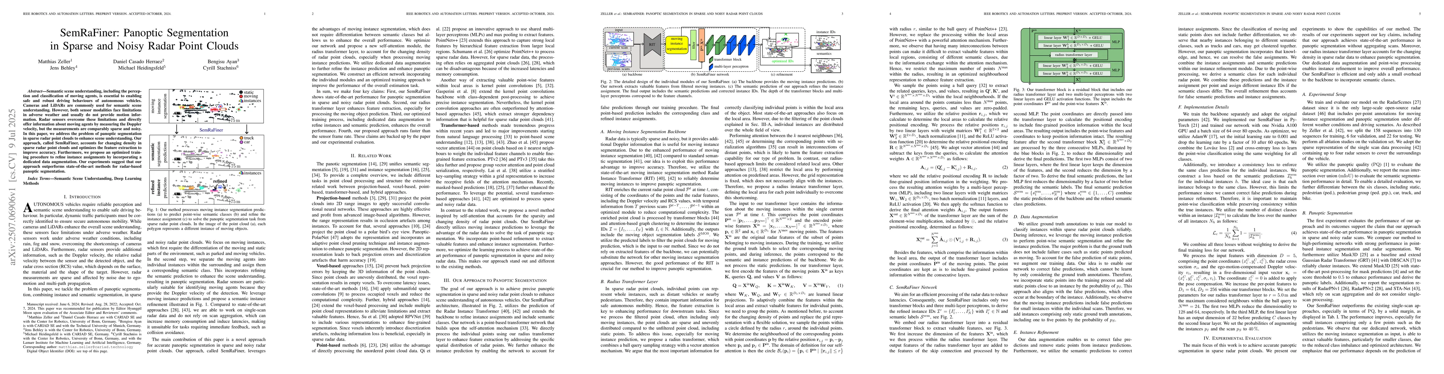
Semantic scene understanding, including the perception and classification of moving agents, is essential to enabling safe and robust driving behaviours of autonomous vehicles. Cameras and LiDARs are c...
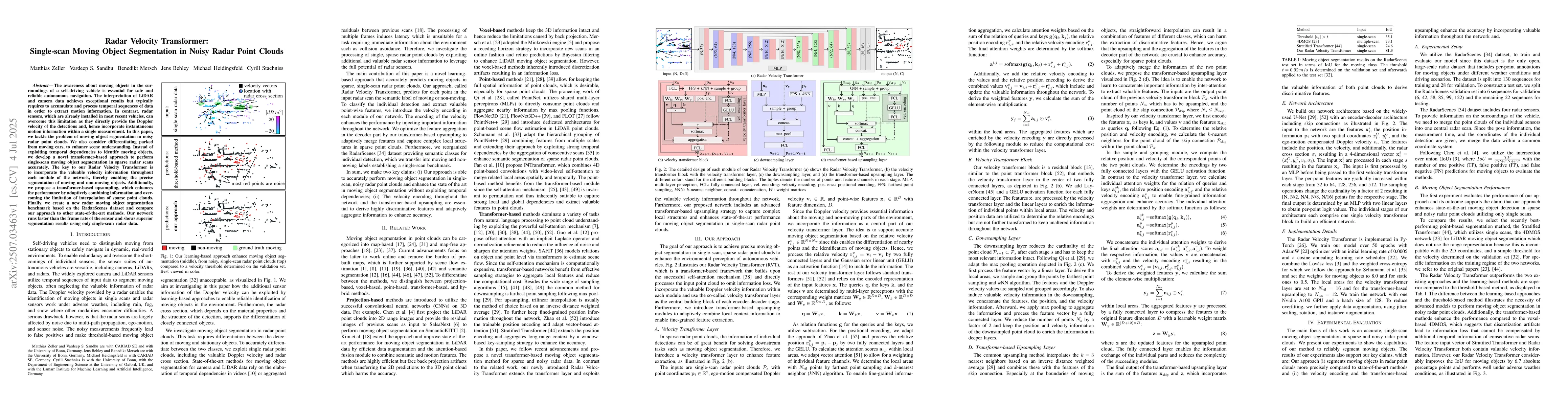
The awareness about moving objects in the surroundings of a self-driving vehicle is essential for safe and reliable autonomous navigation. The interpretation of LiDAR and camera data achieves exceptio...
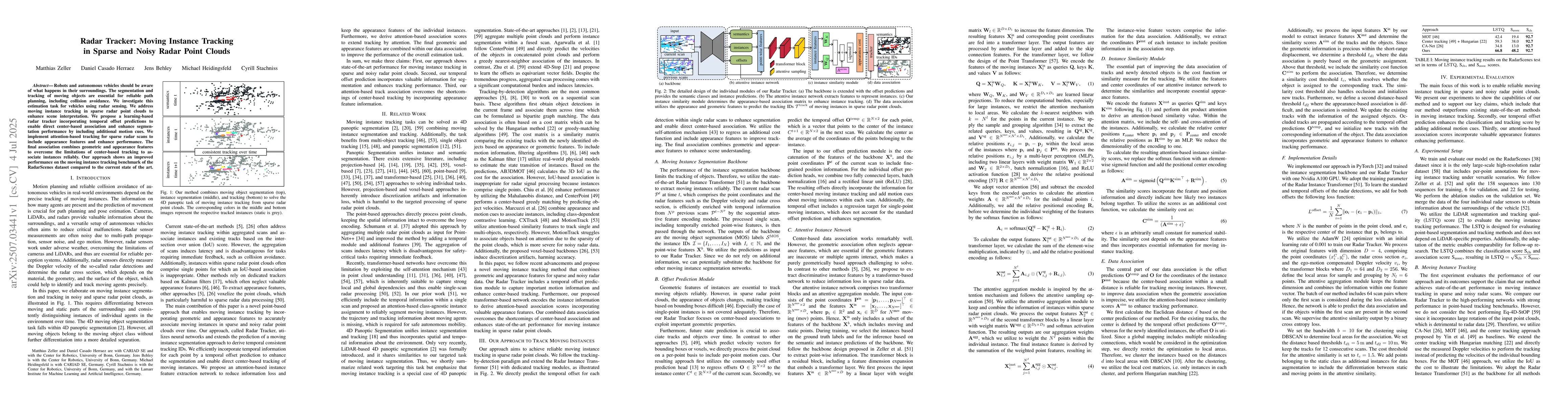
Robots and autonomous vehicles should be aware of what happens in their surroundings. The segmentation and tracking of moving objects are essential for reliable path planning, including collision avoi...
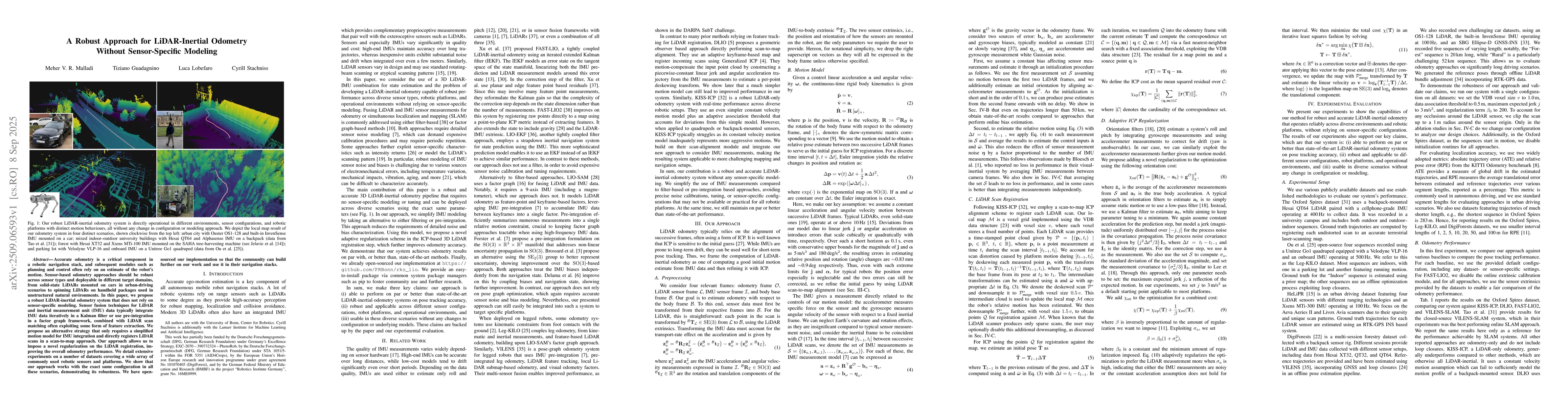
Accurate odometry is a critical component in a robotic navigation stack, and subsequent modules such as planning and control often rely on an estimate of the robot's motion. Sensor-based odometry appr...
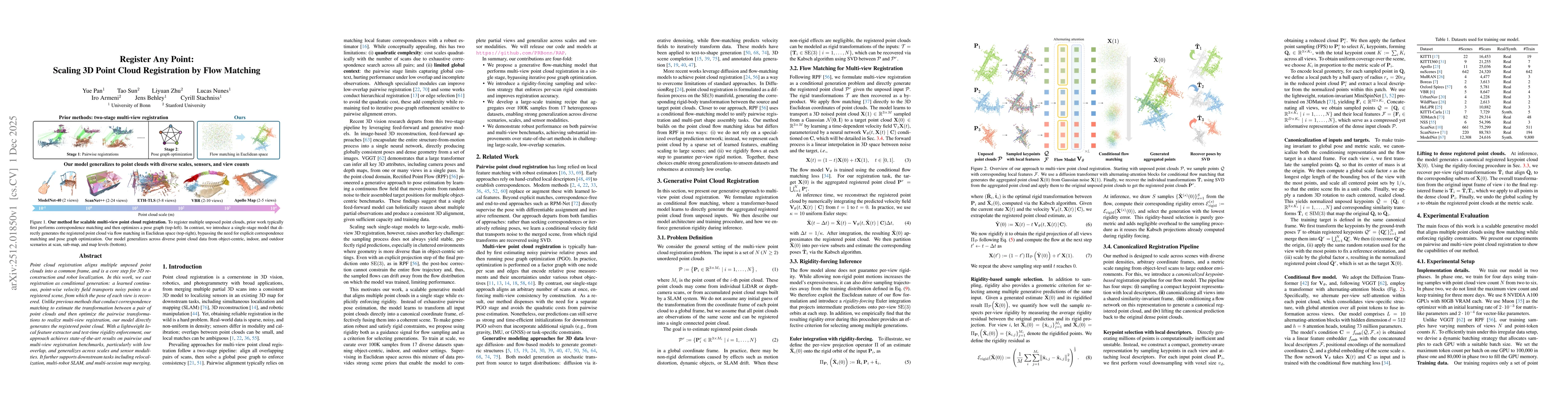
Point cloud registration aligns multiple unposed point clouds into a common frame, and is a core step for 3D reconstruction and robot localization. In this work, we cast registration as conditional ge...
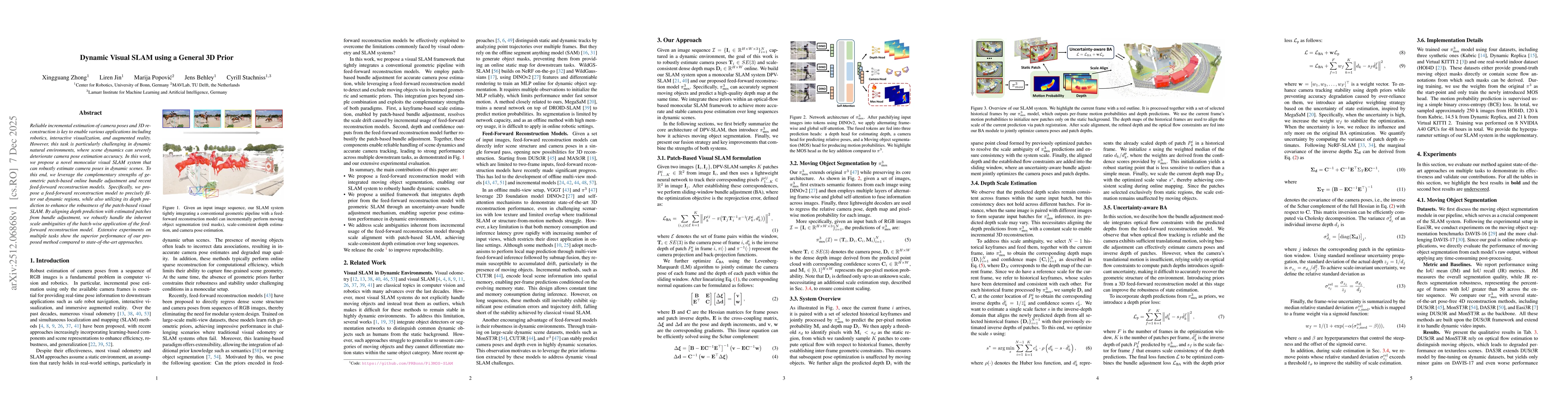
Reliable incremental estimation of camera poses and 3D reconstruction is key to enable various applications including robotics, interactive visualization, and augmented reality. However, this task is ...
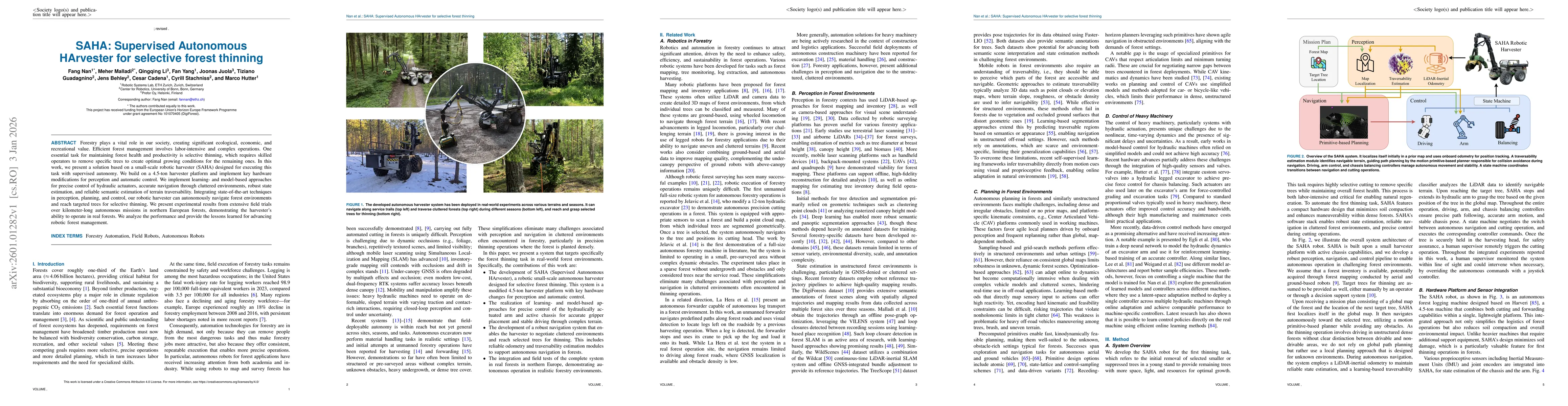
Forestry plays a vital role in our society, creating significant ecological, economic, and recreational value. Efficient forest management involves labor-intensive and complex operations. One essentia...
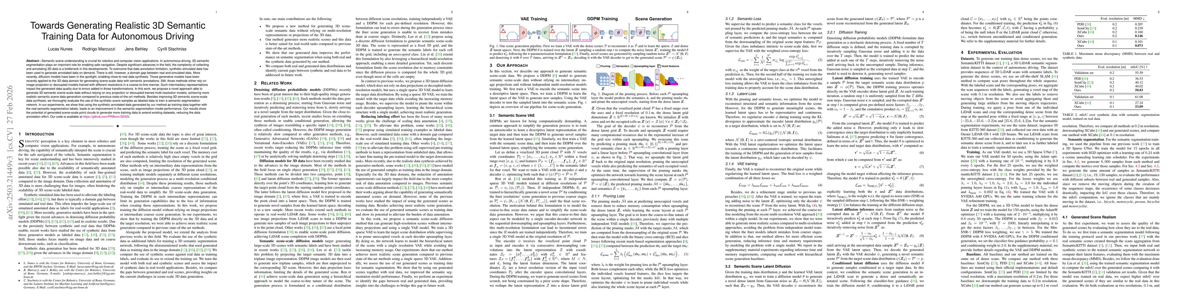
Semantic scene understanding is crucial for robotics and computer vision applications. In autonomous driving, 3D semantic segmentation plays an important role for enabling safe navigation. Despite sig...
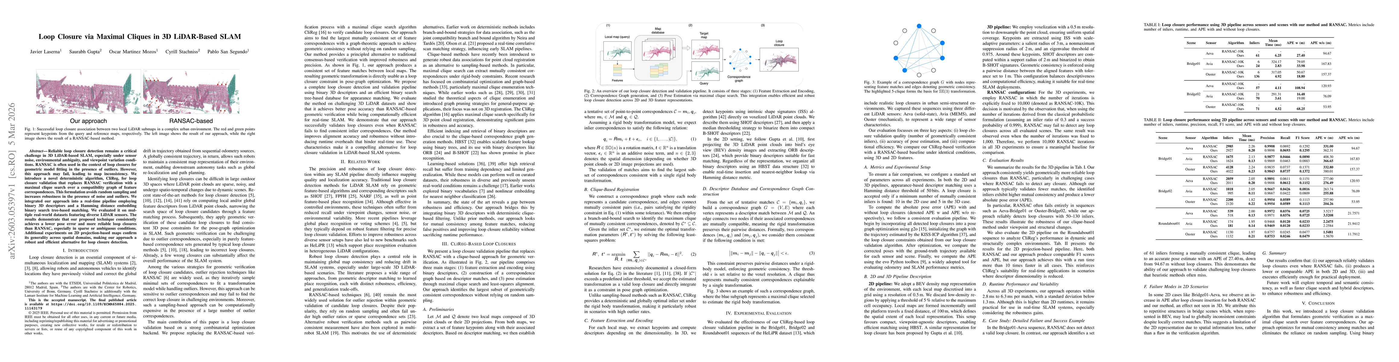
Reliable loop closure detection remains a critical challenge in 3D LiDAR-based SLAM, especially under sensor noise, environmental ambiguity, and viewpoint variation conditions. RANSAC is often used in...
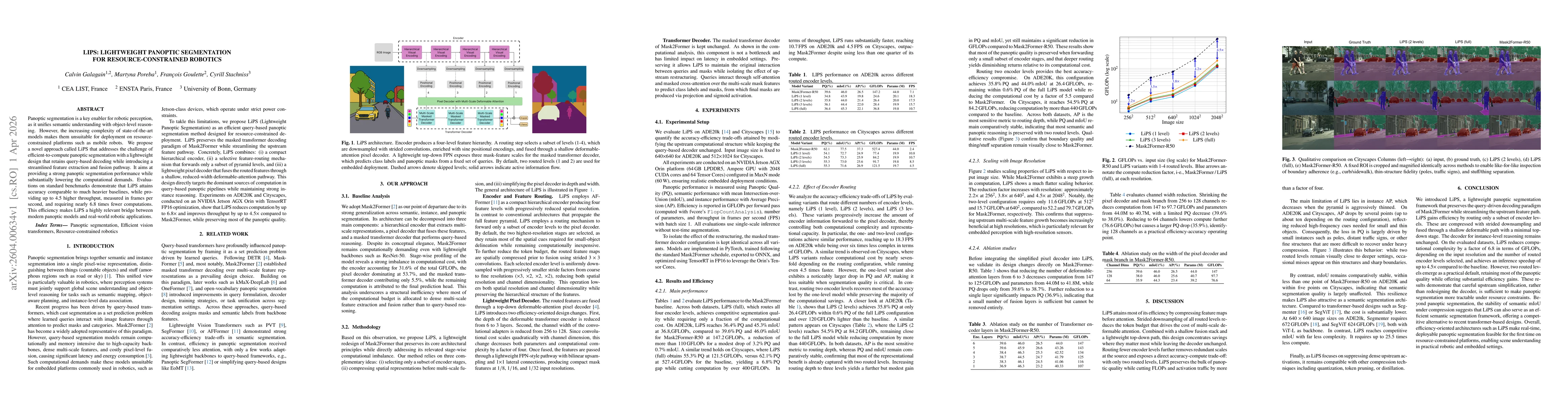
Panoptic segmentation is a key enabler for robotic perception, as it unifies semantic understanding with object-level reasoning. However, the increasing complexity of state-of-the-art models makes the...
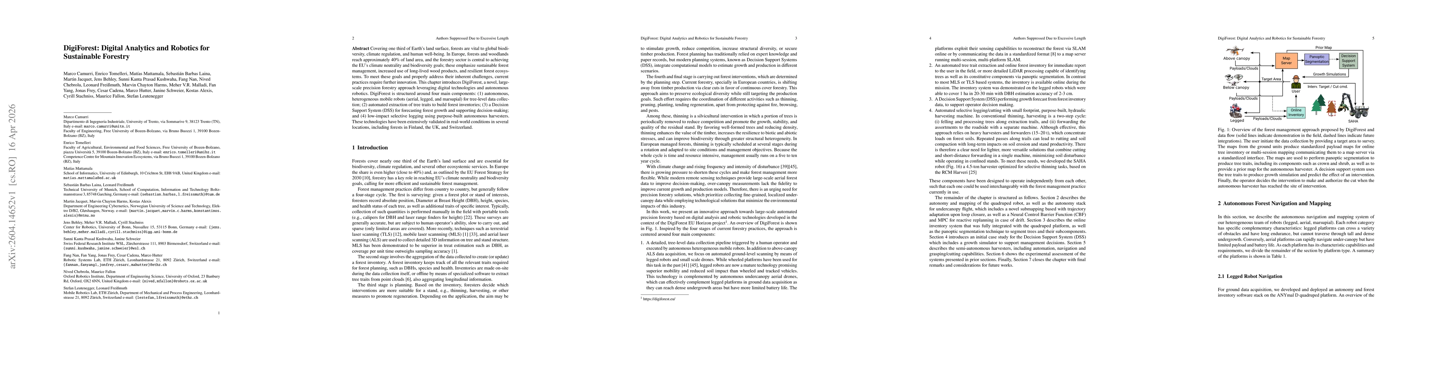
Covering one third of Earth's land surface, forests are vital to global biodiversity, climate regulation, and human well-being. In Europe, forests and woodlands reach approximately 40% of land area, a...
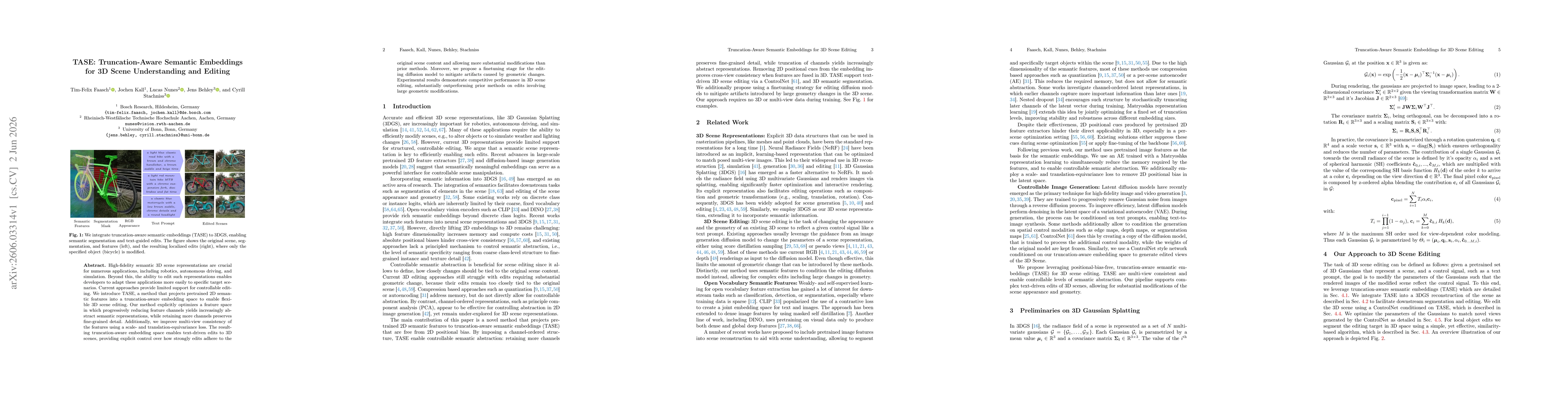
High-fidelity semantic 3D scene representations are crucial for numerous applications, including robotics, autonomous driving, and simulation. Beyond this, the ability to edit such representations ena...
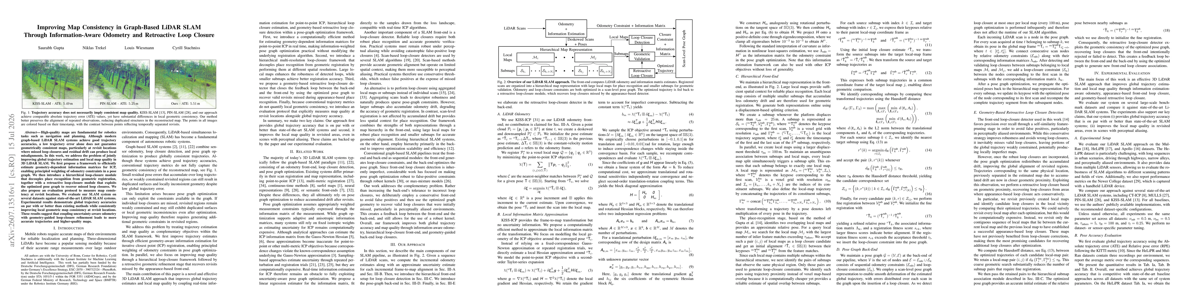
High-quality maps are fundamental for robotics tasks such as navigation and planning. Although modern graph-based LiDAR SLAM systems achieve good trajectory accuracies, a low trajectory error alone do...
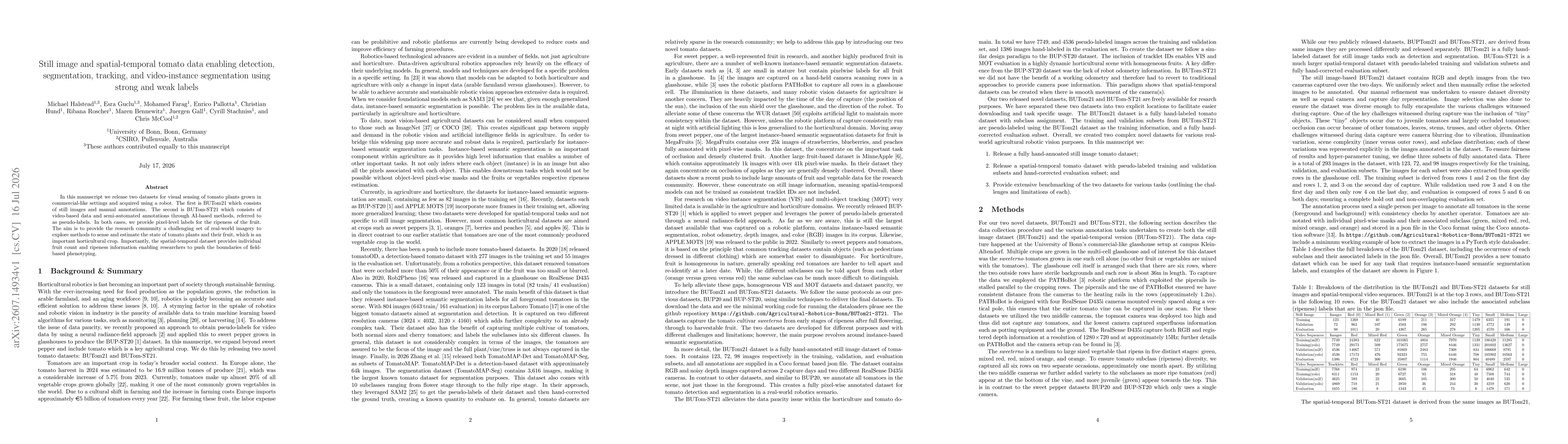
In this manuscript we release two datasets for visual sensing of tomato plants grown in commercial-like settings and acquired using a robot. The first is BUTom21 which consists of still images and man...