ArxivLens
E
Researcher

Edward J. Oughton

27 papers on arXiv

27 arXiv Papers
78 Total Publications
Profile

Academic Profile

Name E. Oughton
Total Papers 78
Scholar Profile View on Semantic Scholar
Metrics

Statistics

27 arXiv Papers
78 Total Publications
Publications

Papers on arXiv

Thumbnail for A Multispectral Automated Transfer Technique (MATT) for machine-driven
  image labeling utilizing the Segment Anything Model (SAM)
arXiv
A Multispectral Automated Transfer Technique (MATT) for machine-driven image labeling utilizing the Segment Anything Model (SAM)

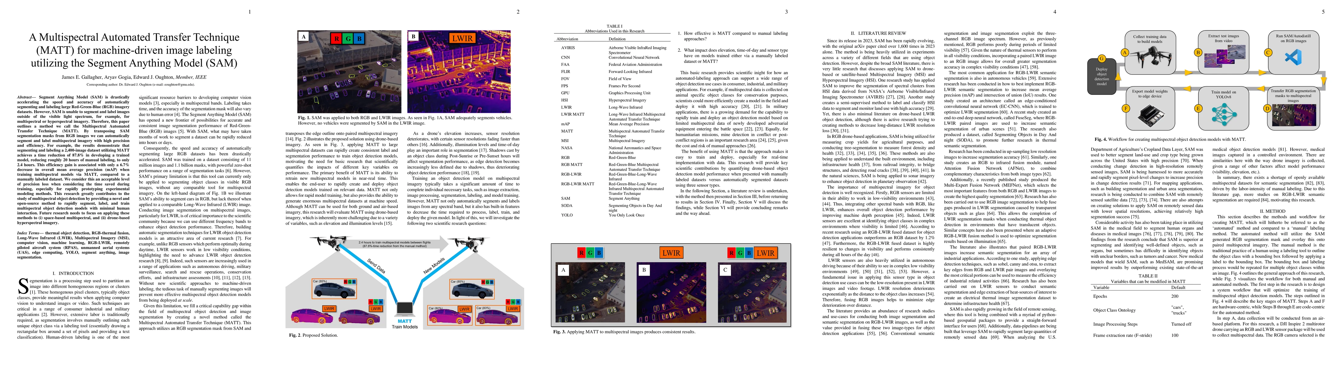
Segment Anything Model (SAM) is drastically accelerating the speed and accuracy of automatically segmenting and labeling large Red-Green-Blue (RGB) imagery datasets. However, SAM is unable to segmen...

Thumbnail for Sustainability assessment of 4G and 5G universal mobile broadband
  strategies
arXiv
Sustainability assessment of 4G and 5G universal mobile broadband strategies

With infrastructure systems lasting for decades, even centuries, there is growing need to assess sustainability impacts. However, compared to energy or transportation networks (which each contribute...

Thumbnail for Global Vulnerability Assessment of Mobile Telecommunications
  Infrastructure to Climate Hazards using Crowdsourced Open Data
arXiv
Global Vulnerability Assessment of Mobile Telecommunications Infrastructure to Climate Hazards using Crowdsourced Open Data

The ongoing change in Earth`s climate is causing an increase in the frequency and severity of climate-related hazards, for example, from coastal flooding, riverine flooding, and tropical cyclones. T...

Thumbnail for What would it cost to connect the unconnected? Estimating global
  universal broadband infrastructure investment
arXiv
What would it cost to connect the unconnected? Estimating global universal broadband infrastructure investment

Roughly 3 billion citizens remain offline, equating to approximately 40 percent of the global population. Therefore, providing Internet connectivity is an essential part of the Sustainable Developme...

Thumbnail for Sustainability assessment of Low Earth Orbit (LEO) satellite broadband
  megaconstellations
arXiv
Sustainability assessment of Low Earth Orbit (LEO) satellite broadband megaconstellations

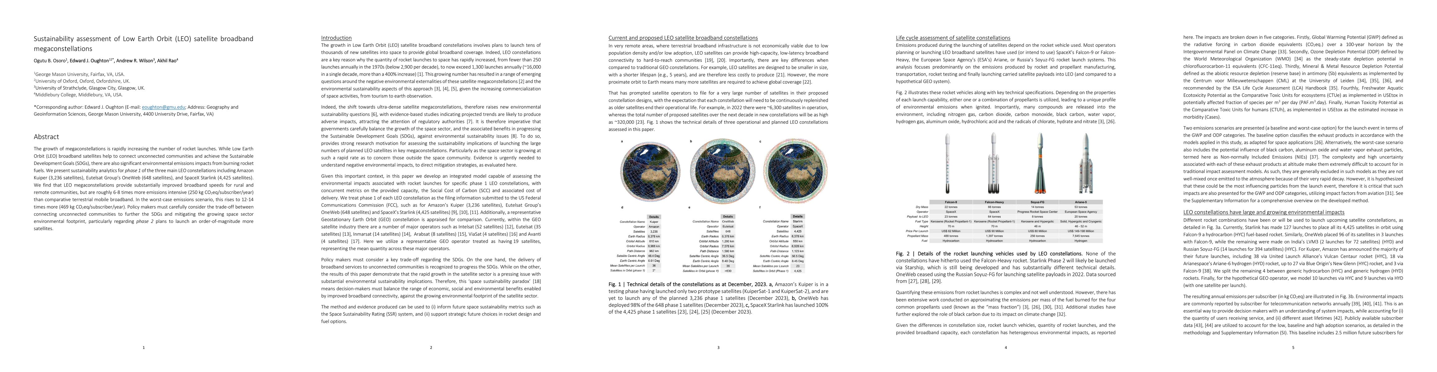
The growth of megaconstellations is rapidly increasing the number of rocket launches. While Low Earth Orbit (LEO) broadband satellites help to connect unconnected communities and achieve the Sustain...

Thumbnail for Crowdsourced data indicates broadband has a positive impact on local
  business creation
arXiv
Crowdsourced data indicates broadband has a positive impact on local business creation

Broadband connectivity is regarded as generally having a positive macroeconomic effect, but we lack evidence as to how it affects key economic activity metrics, such as firm creation, at a very loca...

Thumbnail for Quantifying polarization across political groups on key policy issues
  using sentiment analysis
arXiv
Quantifying polarization across political groups on key policy issues using sentiment analysis

There is growing concern that over the past decade, industrialized democratic nations are becoming increasingly politically polarized. Indeed, elections in the US, UK, France, and Germany have all s...

Thumbnail for The State-of-the-Art Survey on Optimization Methods for Cyber-physical
  Networks
arXiv
The State-of-the-Art Survey on Optimization Methods for Cyber-physical Networks

Cyber-Physical Systems (CPS) are increasingly complex and frequently integrated into modern societies via critical infrastructure systems, products, and services. Consequently, there is a need for r...

Thumbnail for Surveying 5G Techno-Economic Research to Inform the Evaluation of 6G
  Wireless Technologies
arXiv
Surveying 5G Techno-Economic Research to Inform the Evaluation of 6G Wireless Technologies

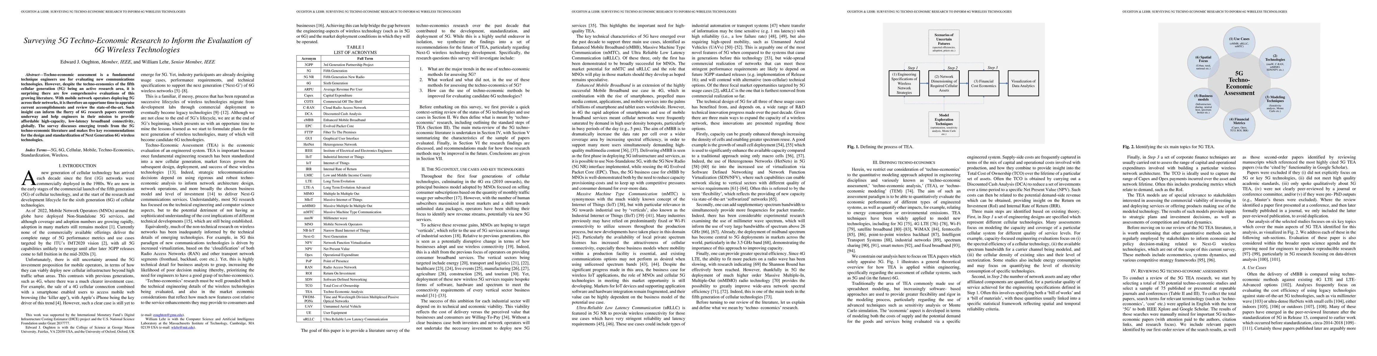
Techno-economic assessment is a fundamental technique engineers use for evaluating new communications technologies. However, despite the techno-economics of the fifth cellular generation (5G) being ...

Thumbnail for A Techno-Economic Cost Framework for Satellite Networks Applied to Low
  Earth Orbit Constellations: Assessing Starlink, OneWeb and Kuiper
arXiv
A Techno-Economic Cost Framework for Satellite Networks Applied to Low Earth Orbit Constellations: Assessing Starlink, OneWeb and Kuiper

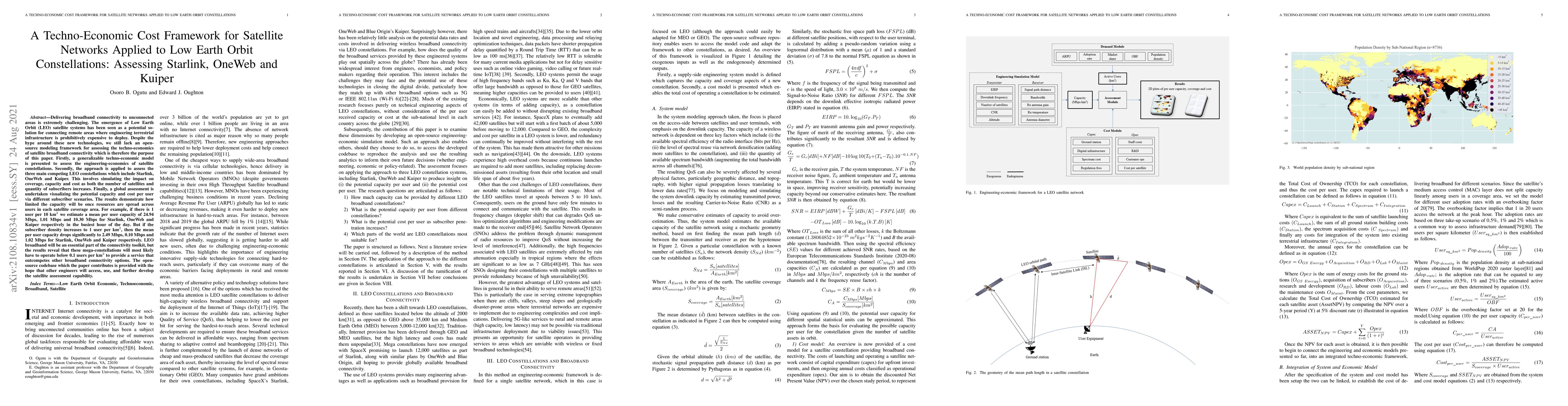
Delivering broadband connectivity to unconnected areas is extremely challenging. The emergence of Low Earth Orbit (LEO) satellite systems has been seen as a potential solution for connecting remote ...

Thumbnail for The Economic Impact of Critical National Infrastructure Failure Due to
  Space Weather
arXiv
The Economic Impact of Critical National Infrastructure Failure Due to Space Weather

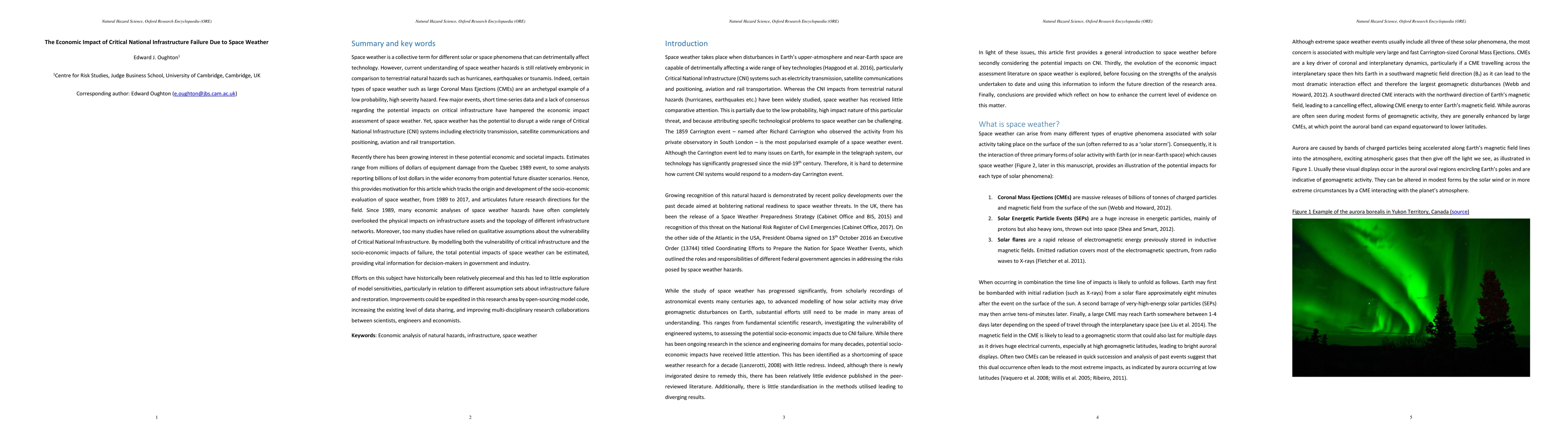
Space weather is a collective term for different solar or space phenomena that can detrimentally affect technology. However, current understanding of space weather hazards is still relatively embryo...

Thumbnail for Engineering-Economic Evaluation of Diffractive Non-Line-Of-Sight
  Backhaul (e3nb): A Techno-economic Model for 3D Wireless Backhaul Assessment
arXiv
Engineering-Economic Evaluation of Diffractive Non-Line-Of-Sight Backhaul (e3nb): A Techno-economic Model for 3D Wireless Backhaul Assessment

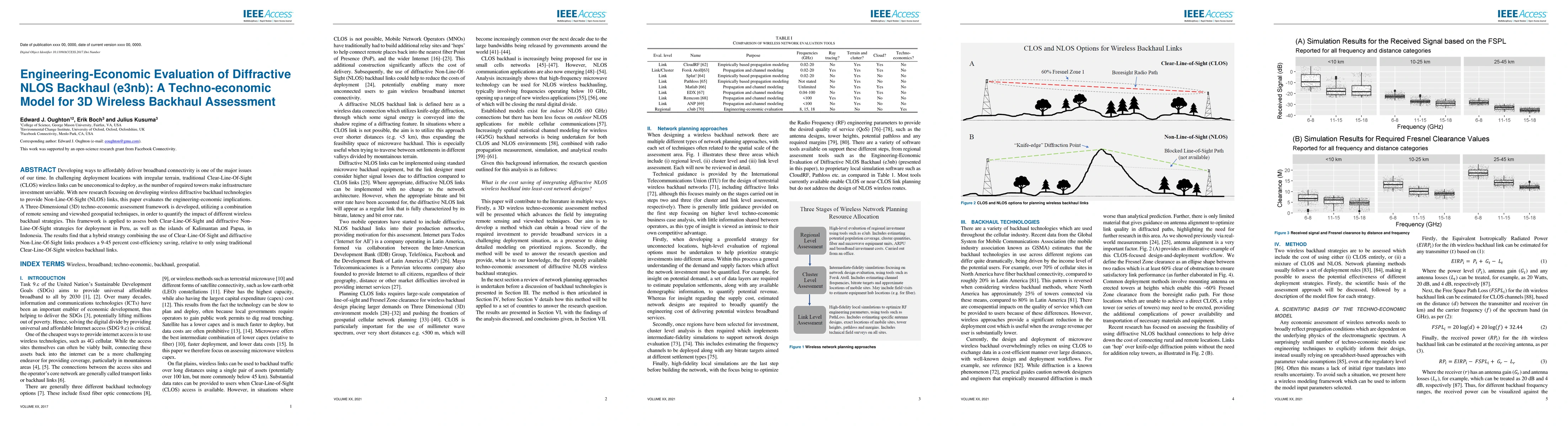
Developing ways to affordably deliver broadband connectivity is one of the major issues of our time. In challenging deployment locations with irregular terrain, traditional Clear-Line-Of-Sight (CLOS...

Thumbnail for Predicting cell phone adoption metrics using satellite imagery
arXiv
Predicting cell phone adoption metrics using satellite imagery

Approximately half of the global population does not have access to the internet, even though digital connectivity can reduce poverty by revolutionizing economic development opportunities. Due to a ...

Thumbnail for Surveying You Only Look Once (YOLO) Multispectral Object Detection
  Advancements, Applications And Challenges
arXiv
Surveying You Only Look Once (YOLO) Multispectral Object Detection Advancements, Applications And Challenges

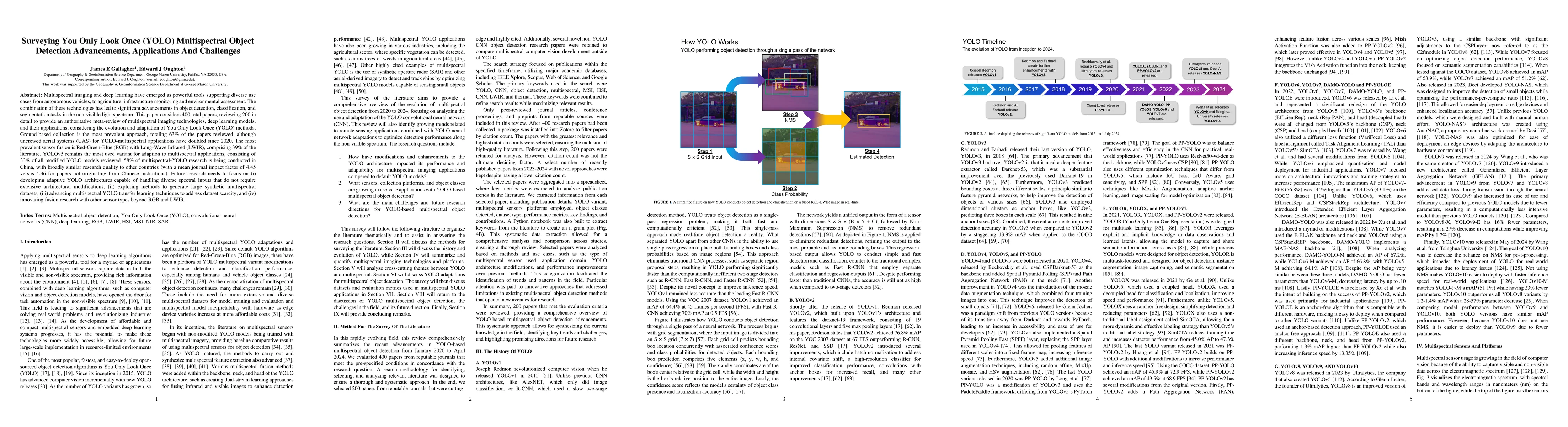
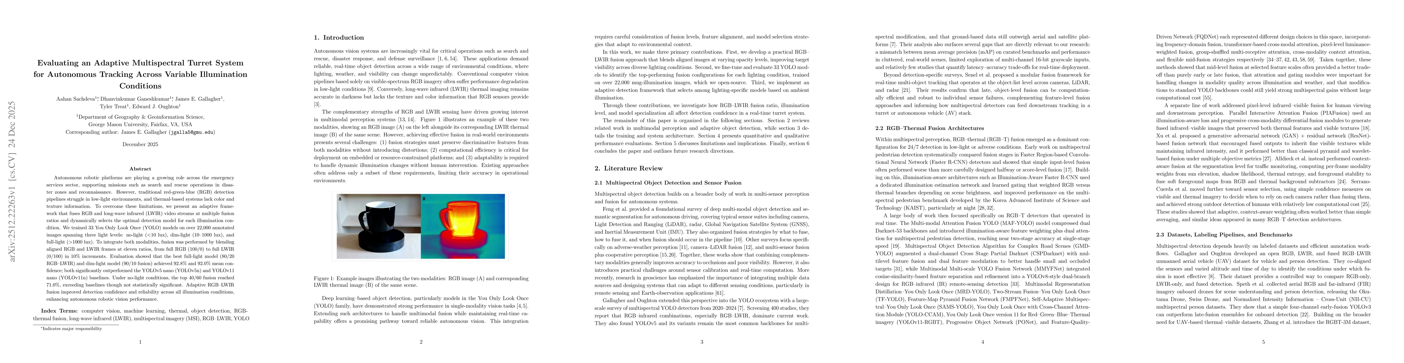
Multispectral imaging and deep learning have emerged as powerful tools supporting diverse use cases from autonomous vehicles, to agriculture, infrastructure monitoring and environmental assessment. Th...

Thumbnail for Geospatial sustainability assessment of universal
  Fiber-To-The-Neighborhood (FTTnb) broadband infrastructure strategies for
  Sub-Saharan Africa
arXiv
Geospatial sustainability assessment of universal Fiber-To-The-Neighborhood (FTTnb) broadband infrastructure strategies for Sub-Saharan Africa

Broadband Internet access is an important way to help achieve the Sustainable Development Goals. Currently, fixed fiber infrastructure is essential for providing universal broadband, but has received ...

Thumbnail for The role of broadband connectivity in achieving Sustainable Development
  Goals (SDGs)
arXiv
The role of broadband connectivity in achieving Sustainable Development Goals (SDGs)

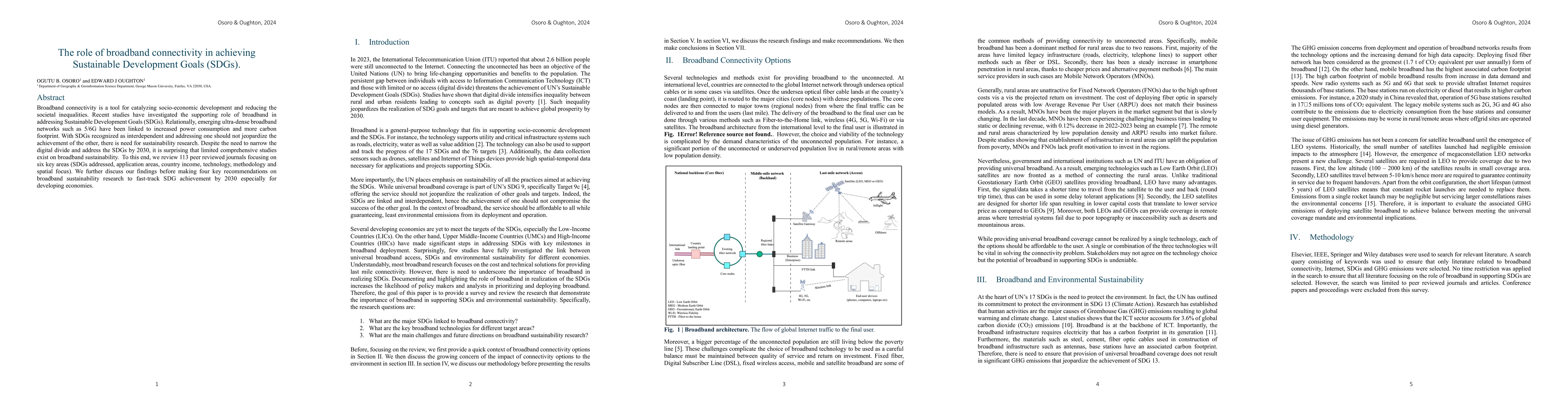
Broadband connectivity is a tool for catalyzing socio-economic development and reducing the societal inequalities. Recent studies have investigated the supporting role of broadband in addressing Susta...

Thumbnail for A physics-engineering-economic model coupling approach for estimating
  the socio-economic impacts of space weather scenarios
arXiv
A physics-engineering-economic model coupling approach for estimating the socio-economic impacts of space weather scenarios

There is growing concern about our vulnerability to space weather hazards and the disruption critical infrastructure failures could cause to society and the economy. However, the socio-economic impact...

Thumbnail for A Reproducible Method for Mapping Electricity Transmission
  Infrastructure for Space Weather Risk Assessment
arXiv
A Reproducible Method for Mapping Electricity Transmission Infrastructure for Space Weather Risk Assessment

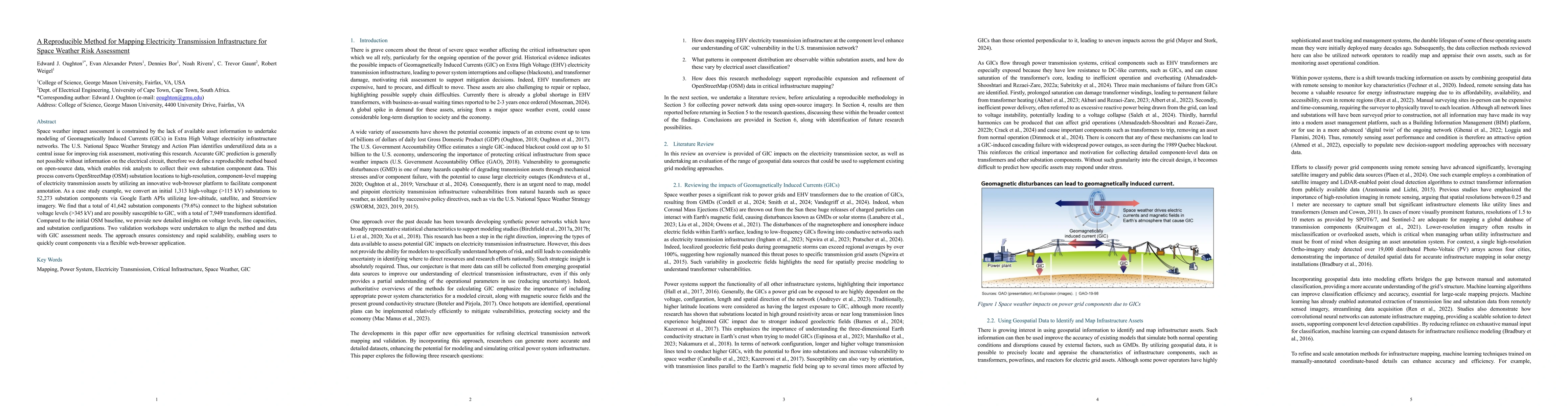
Space weather impact assessment is constrained by the lack of available asset information to undertake modeling of Geomagnetically Induced Currents (GICs) in Extra High Voltage electricity infrastruct...

Thumbnail for ORAN Drives Higher Returns on Investments in Urban and Suburban Regions
arXiv
ORAN Drives Higher Returns on Investments in Urban and Suburban Regions

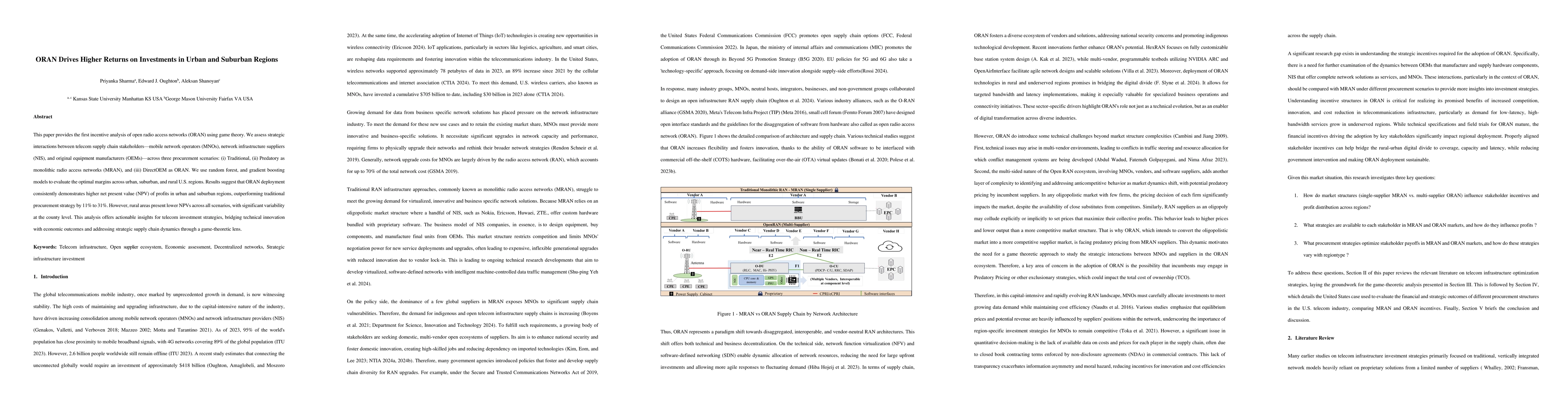
This paper provides the first incentive analysis of open radio access networks (ORAN) using game theory. We assess strategic interactions between telecom supply chain stakeholders: mobile network oper...

Thumbnail for VORTEX: A Spatial Computing Framework for Optimized Drone Telemetry
  Extraction from First-Person View Flight Data
arXiv
VORTEX: A Spatial Computing Framework for Optimized Drone Telemetry Extraction from First-Person View Flight Data

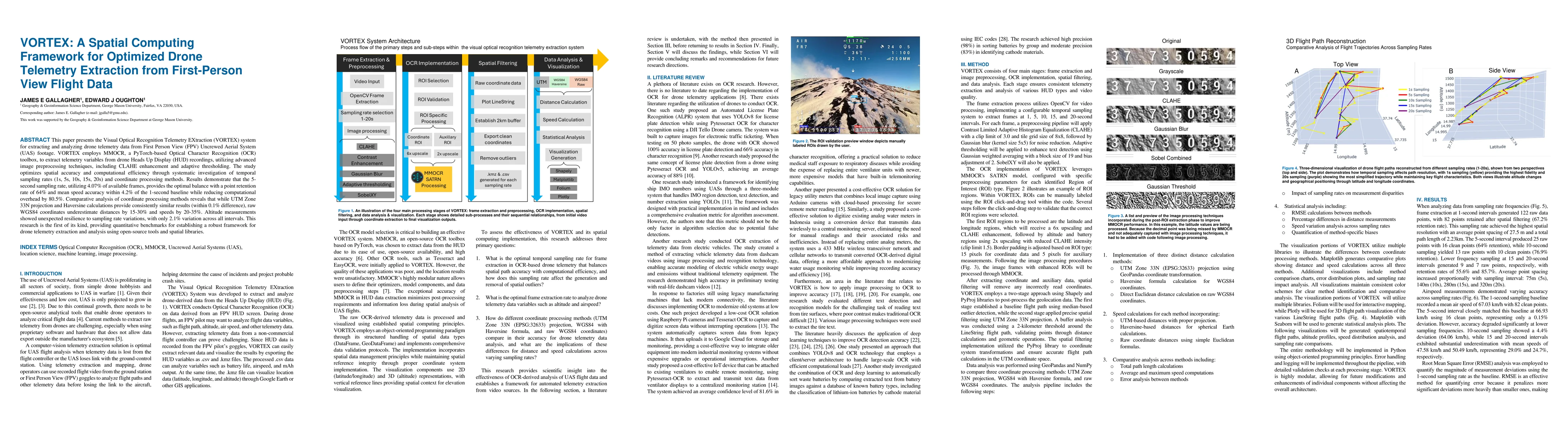
This paper presents the Visual Optical Recognition Telemetry EXtraction (VORTEX) system for extracting and analyzing drone telemetry data from First Person View (FPV) Uncrewed Aerial System (UAS) foot...

Thumbnail for Greenhouse Gas (GHG) Emissions Poised to Rocket: Modeling the
  Environmental Impact of LEO Satellite Constellations
arXiv
Greenhouse Gas (GHG) Emissions Poised to Rocket: Modeling the Environmental Impact of LEO Satellite Constellations

The proliferation of satellite megaconstellations in low Earth orbit (LEO) represents a significant advancement in global broadband connectivity. However, we urgently need to understand the potential ...

Thumbnail for Assessing the economic benefits of space weather mitigation investment
  decisions: Evidence from Aotearoa New Zealand
arXiv
Assessing the economic benefits of space weather mitigation investment decisions: Evidence from Aotearoa New Zealand

Space weather events pose a growing threat to modern economies, yet their macroeconomic consequences still remain underexplored. This study presents the first dedicated economic assessment of geomagne...

Thumbnail for AMLID: An Adaptive Multispectral Landmine Identification Dataset for Drone-Based Detection
arXiv
AMLID: An Adaptive Multispectral Landmine Identification Dataset for Drone-Based Detection

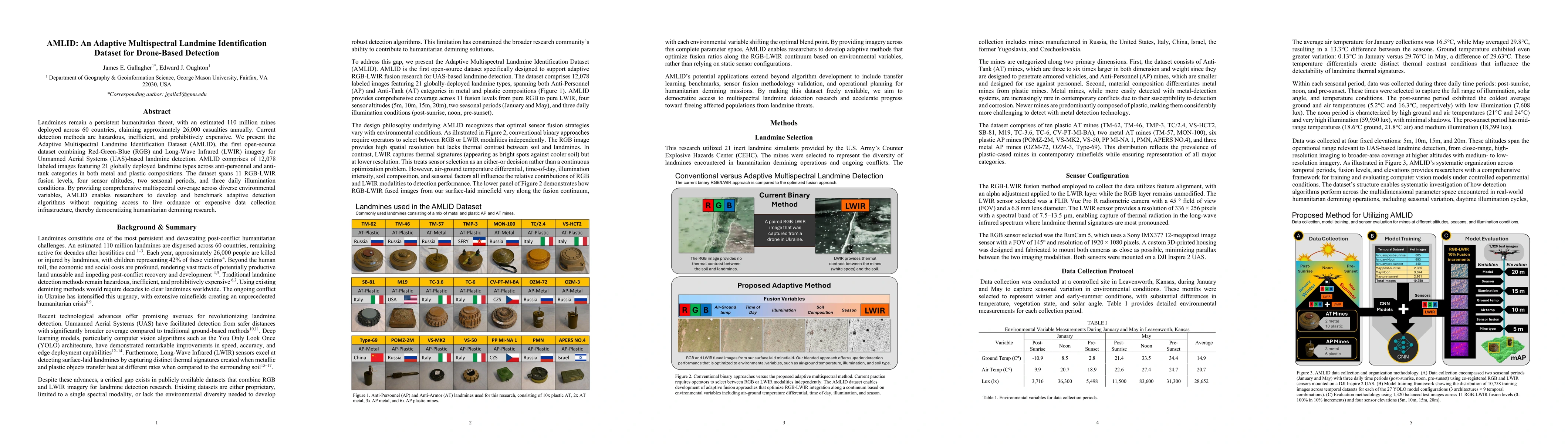
Landmines remain a persistent humanitarian threat, with an estimated 110 million mines deployed across 60 countries, claiming approximately 26,000 casualties annually. Current detection methods are ha...

Thumbnail for Multi-temporal Adaptive Red-Green-Blue and Long-Wave Infrared Fusion for You Only Look Once-Based Landmine Detection from Unmanned Aerial Systems
arXiv
Multi-temporal Adaptive Red-Green-Blue and Long-Wave Infrared Fusion for You Only Look Once-Based Landmine Detection from Unmanned Aerial Systems

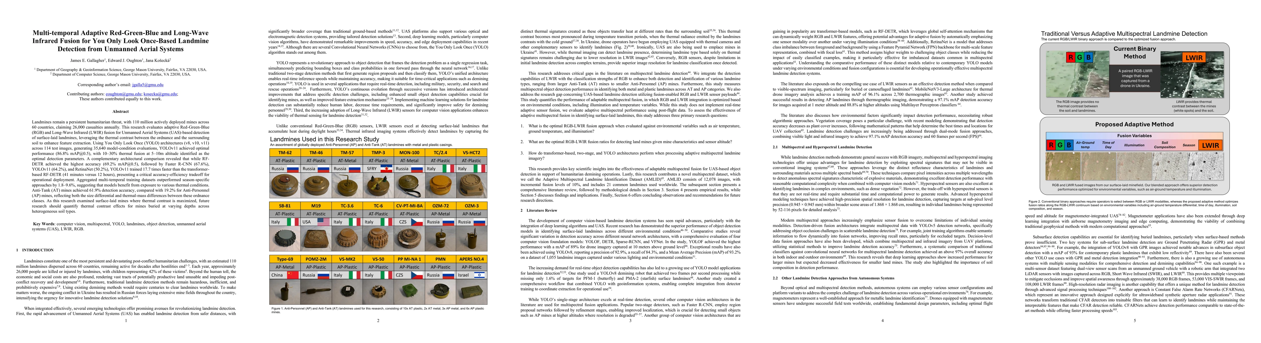
Landmines remain a persistent humanitarian threat, with 110 million actively deployed mines across 60 countries, claiming 26,000 casualties annually. This research evaluates adaptive Red-Green-Blue (R...

Thumbnail for Comparing Object Detection Models for Electrical Substation Component Mapping
arXiv
Comparing Object Detection Models for Electrical Substation Component Mapping

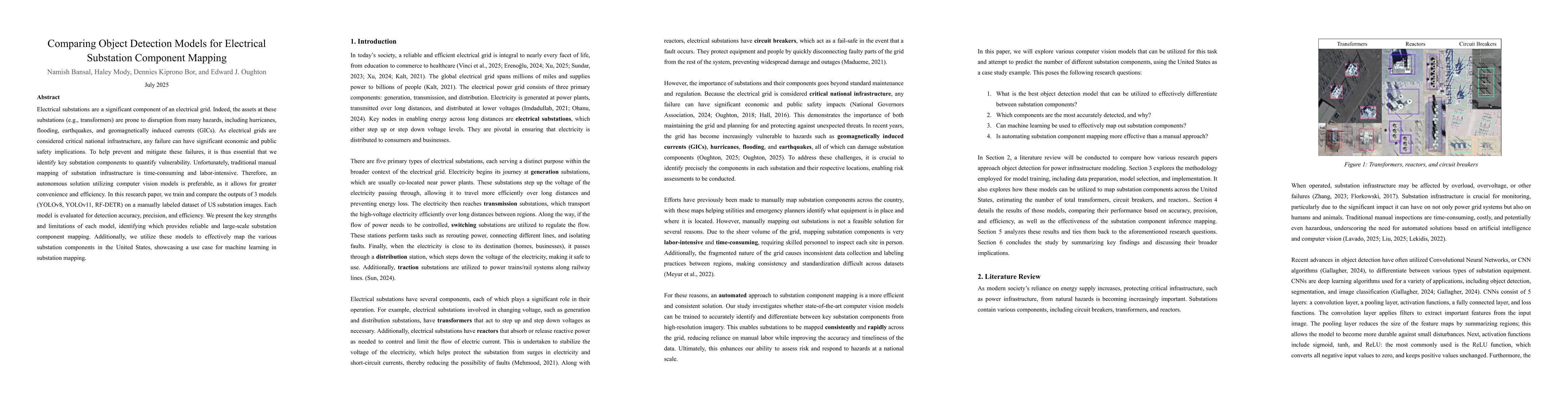
Electrical substations are a significant component of an electrical grid. Indeed, the assets at these substations (e.g., transformers) are prone to disruption from many hazards, including hurricanes, ...

Thumbnail for Evaluating an Adaptive Multispectral Turret System for Autonomous Tracking Across Variable Illumination Conditions
arXiv
Evaluating an Adaptive Multispectral Turret System for Autonomous Tracking Across Variable Illumination Conditions

Autonomous robotic platforms are playing a growing role across the emergency services sector, supporting missions such as search and rescue operations in disaster zones and reconnaissance. However, tr...

Thumbnail for Preparing for the Next Carrington: Spatiotemporal Agent-Based Modeling for Safeguarding Satellite Infrastructure Under Extreme Space Weather Disturbances
arXiv
Preparing for the Next Carrington: Spatiotemporal Agent-Based Modeling for Safeguarding Satellite Infrastructure Under Extreme Space Weather Disturbances

Extreme space weather poses an existential threat to modern satellite infrastructure, with a Carrington-class solar storm projected to cause economic losses of billions of dollars per day. Due to the ...

This website uses cookies to ensure you get the best experience. Learn more