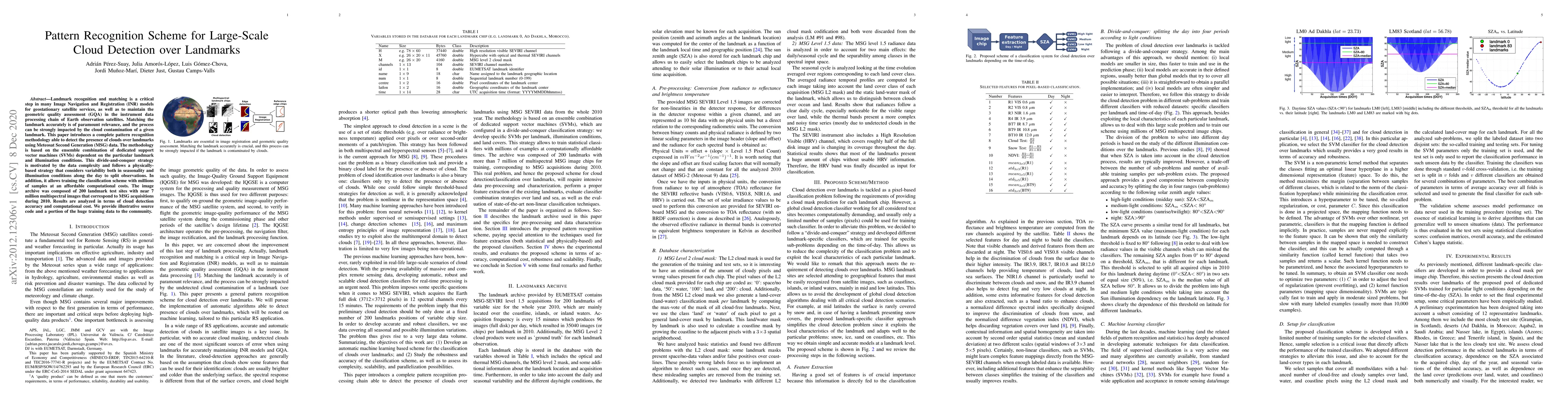
Academic Profile
Statistics
Similar Authors
Papers on arXiv
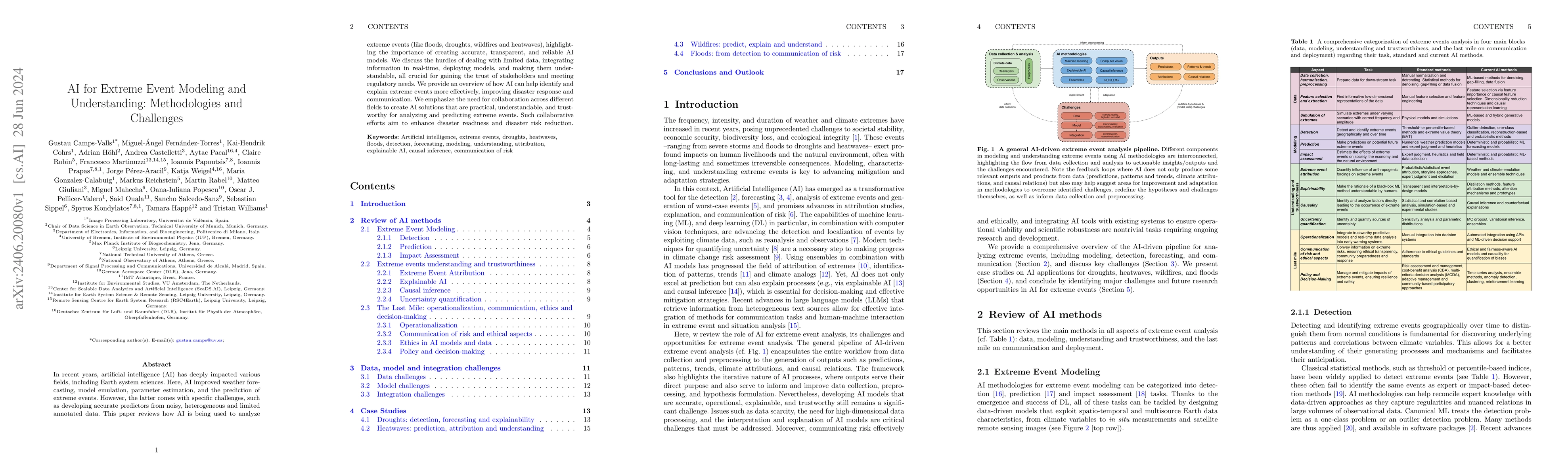
In recent years, artificial intelligence (AI) has deeply impacted various fields, including Earth system sciences. Here, AI improved weather forecasting, model emulation, parameter estimation, and the...
With climate extremes' rising frequency and intensity, robust analytical tools are crucial to predict their impacts on terrestrial ecosystems. Machine learning techniques show promise but require well...
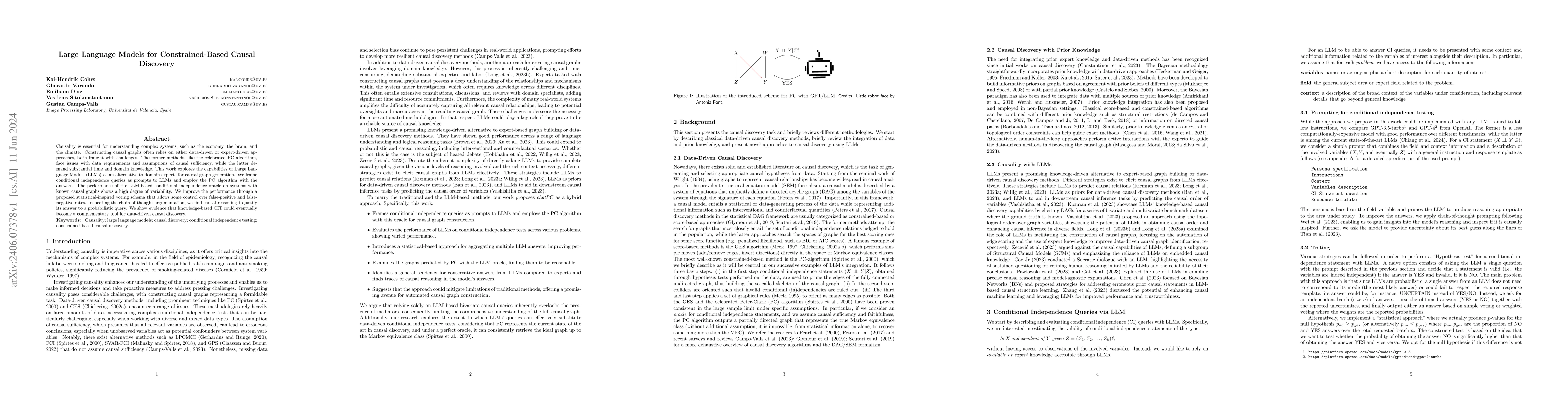
Causality is essential for understanding complex systems, such as the economy, the brain, and the climate. Constructing causal graphs often relies on either data-driven or expert-driven approaches, ...
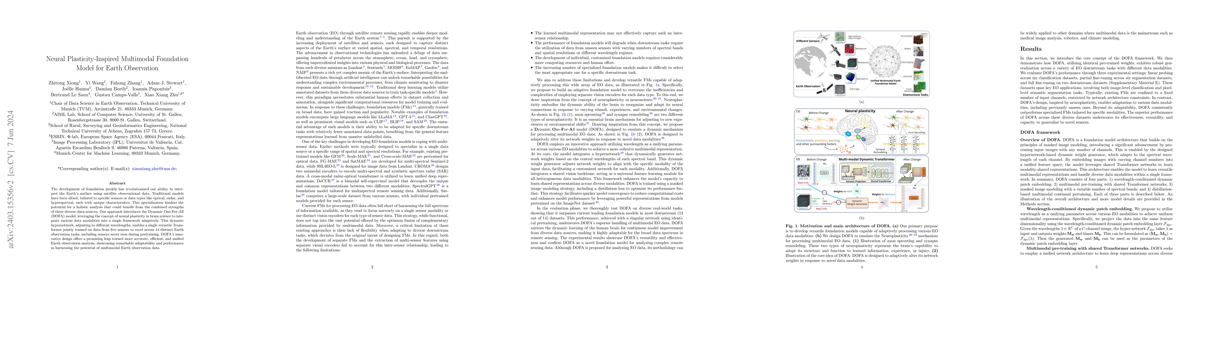
The development of foundation models has revolutionized our ability to interpret the Earth's surface using satellite observational data. Traditional models have been siloed, tailored to specific sen...
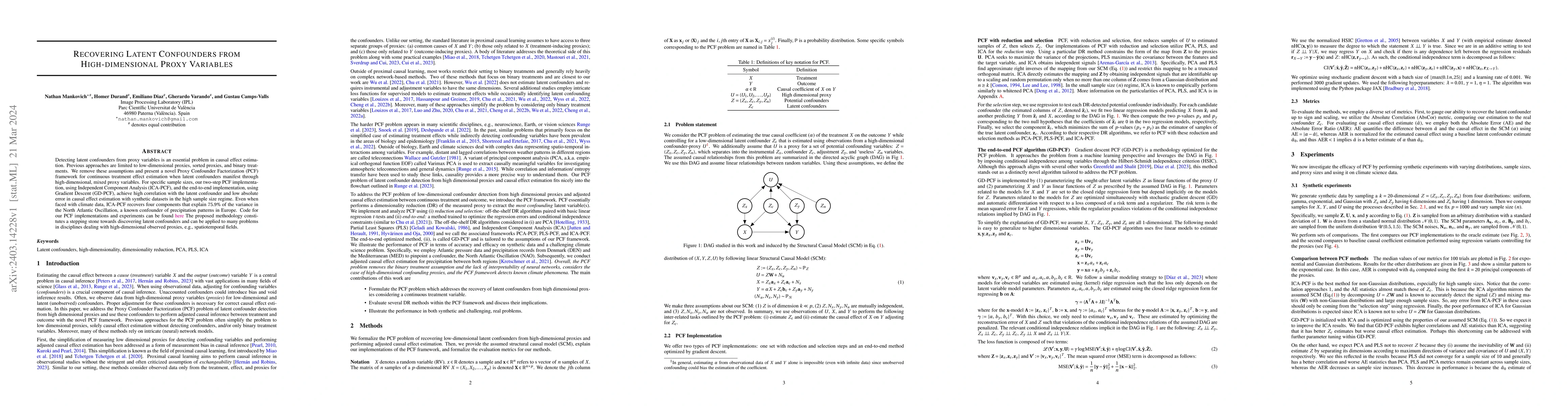
Detecting latent confounders from proxy variables is an essential problem in causal effect estimation. Previous approaches are limited to low-dimensional proxies, sorted proxies, and binary treatmen...

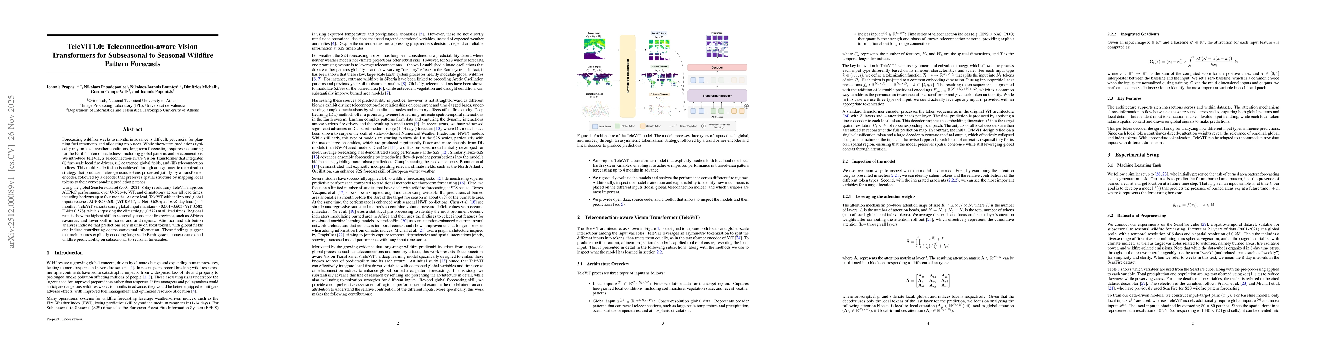
Wildfire forecasting is notoriously hard due to the complex interplay of different factors such as weather conditions, vegetation types and human activities. Deep learning models show promise in dea...
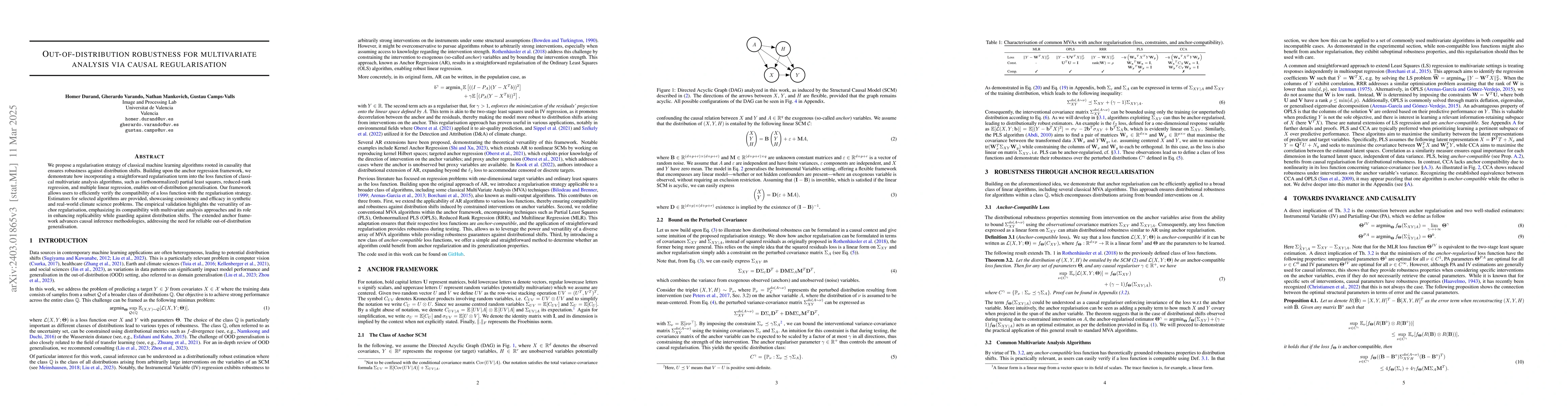
We introduce a causal regularisation extension to anchor regression (AR) for improved out-of-distribution (OOD) generalisation. We present anchor-compatible losses, aligning with the anchor framewor...
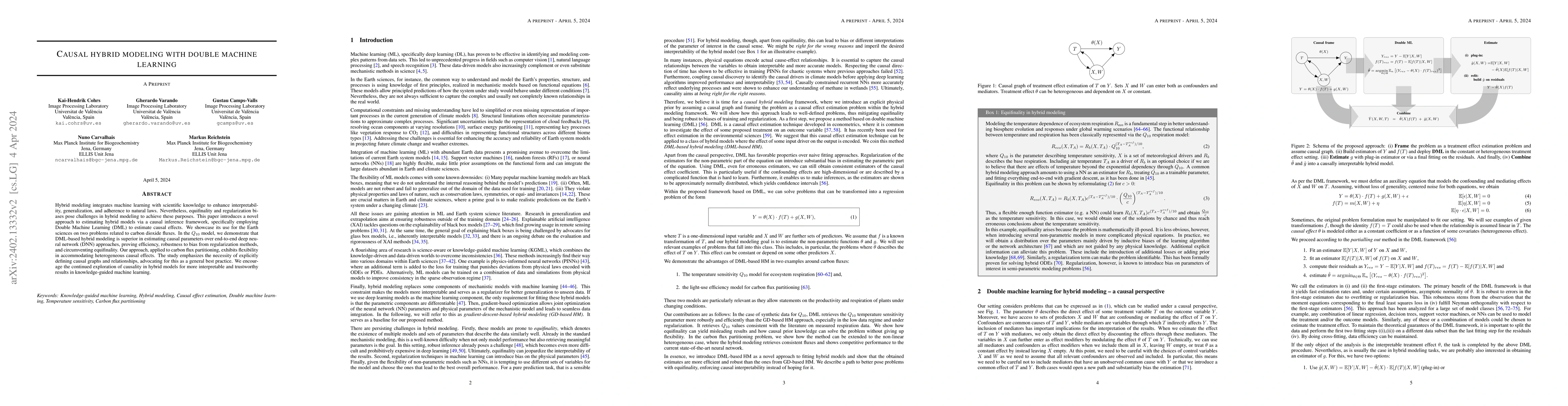
Hybrid modeling integrates machine learning with scientific knowledge to enhance interpretability, generalization, and adherence to natural laws. Nevertheless, equifinality and regularization biases...
Principal component analysis (PCA), along with its extensions to manifolds and outlier contaminated data, have been indispensable in computer vision and machine learning. In this work, we present a ...
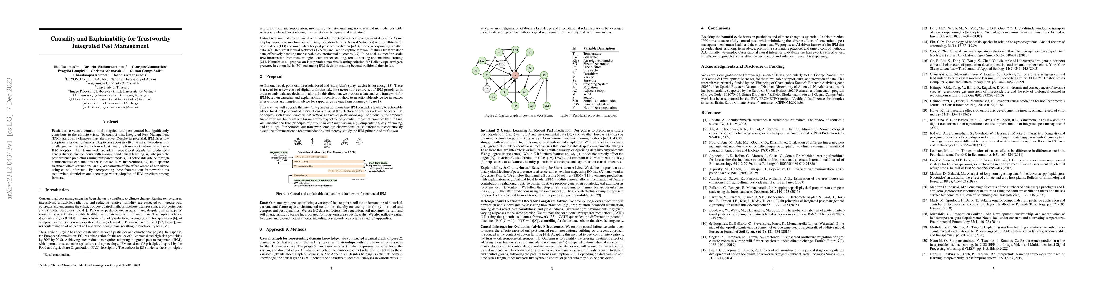
Pesticides serve as a common tool in agricultural pest control but significantly contribute to the climate crisis. To combat this, Integrated Pest Management (IPM) stands as a climate-smart alternat...
In the face of climate change-induced droughts, vulnerable regions encounter severe threats to food security, demanding urgent humanitarian assistance. This paper introduces a causal inference frame...
Granger causality (GC) is often considered not an actual form of causality. Still, it is arguably the most widely used method to assess the predictability of a time series from another one. Granger ...
Wildfires are increasingly exacerbated as a result of climate change, necessitating advanced proactive measures for effective mitigation. It is important to forecast wildfires weeks and months in ad...
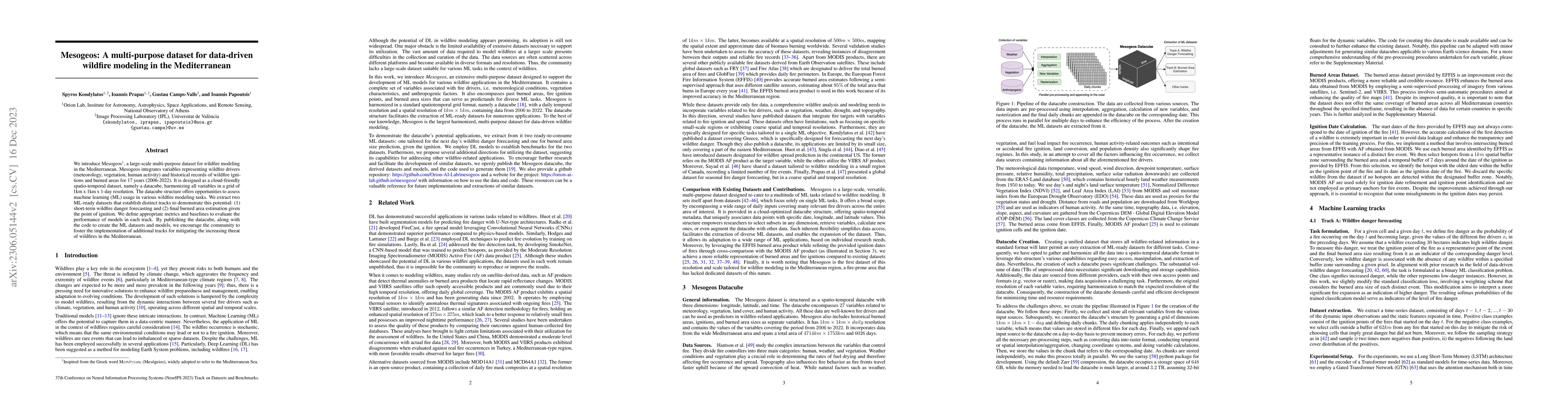
We introduce Mesogeos, a large-scale multi-purpose dataset for wildfire modeling in the Mediterranean. Mesogeos integrates variables representing wildfire drivers (meteorology, vegetation, human act...
Physics is a field of science that has traditionally used the scientific method to answer questions about why natural phenomena occur and to make testable models that explain the phenomena. Discover...
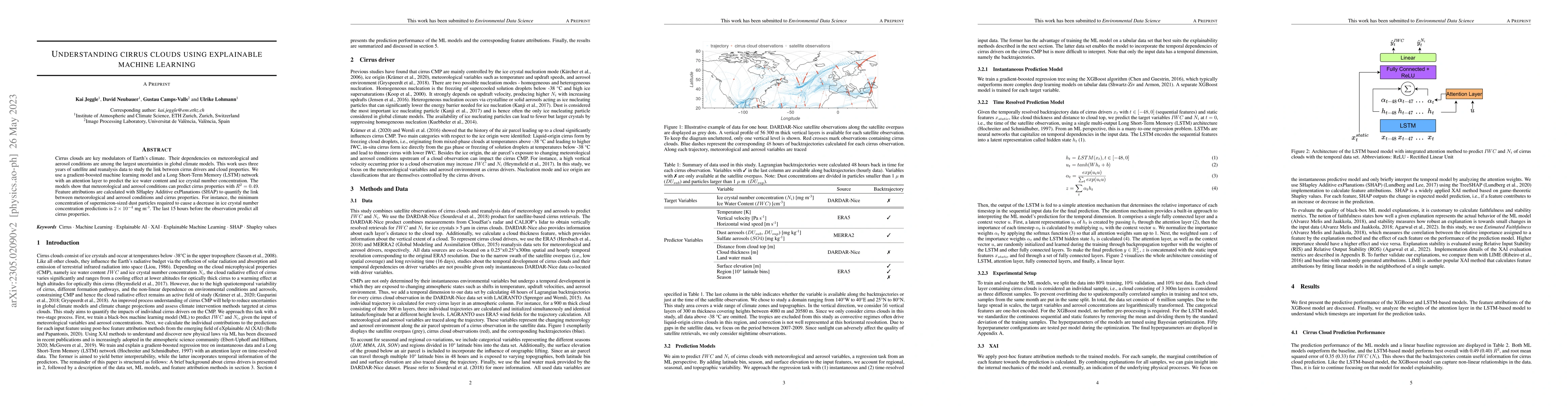
Cirrus clouds are key modulators of Earth's climate. Their dependencies on meteorological and aerosol conditions are among the largest uncertainties in global climate models. This work uses three ye...
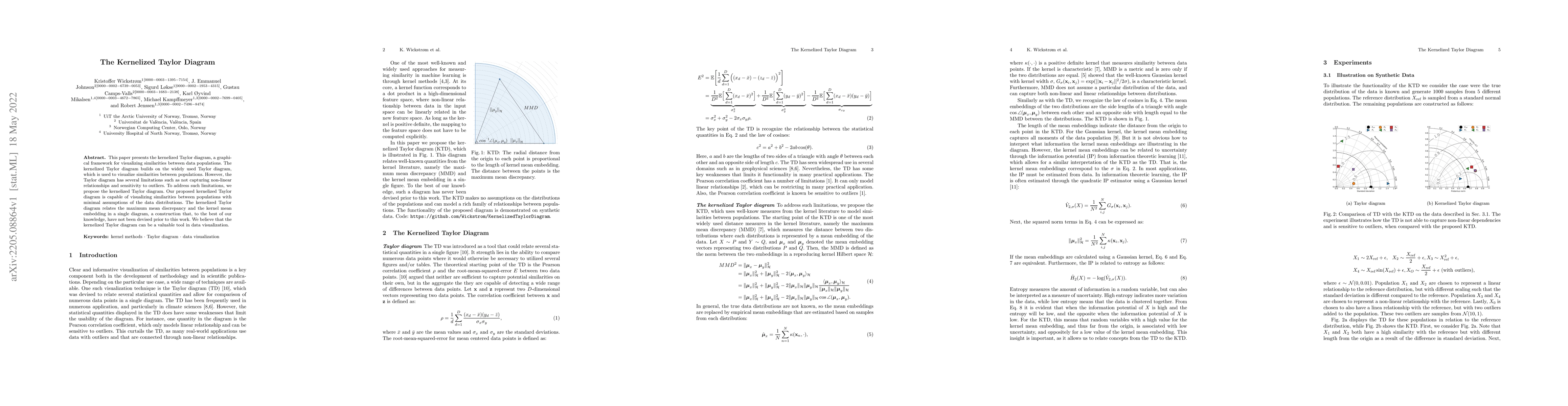
This paper presents the kernelized Taylor diagram, a graphical framework for visualizing similarities between data populations. The kernelized Taylor diagram builds on the widely used Taylor diagram...
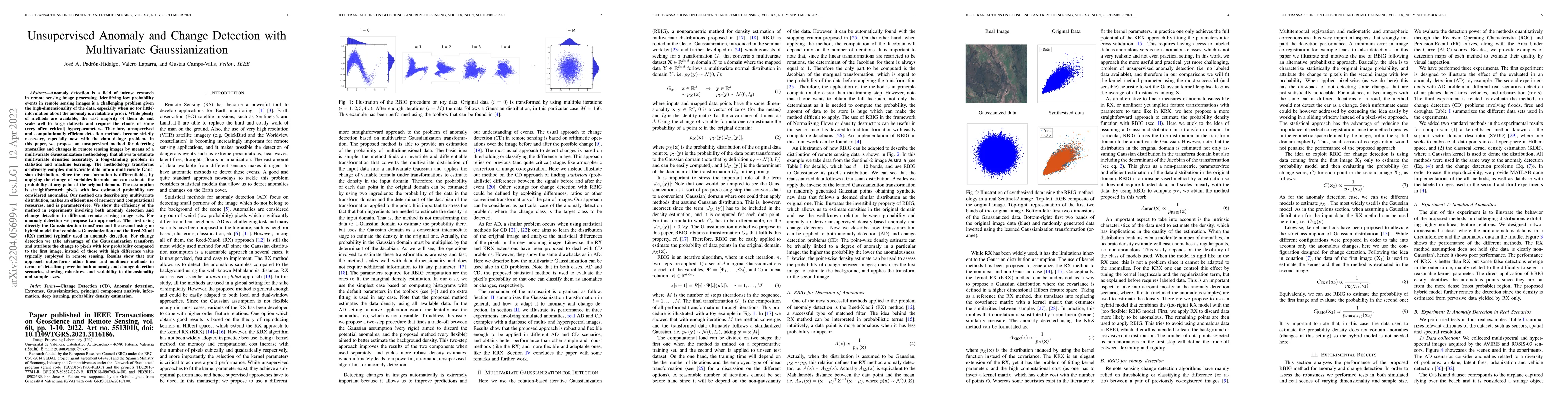
Anomaly detection is a field of intense research. Identifying low probability events in data/images is a challenging problem given the high-dimensionality of the data, especially when no (or little)...
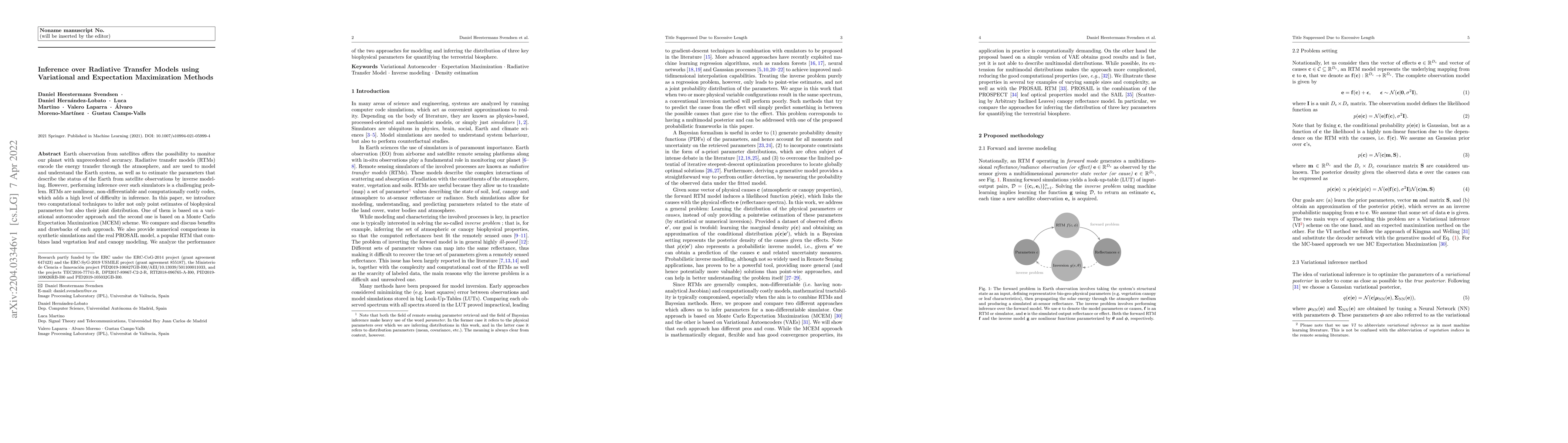
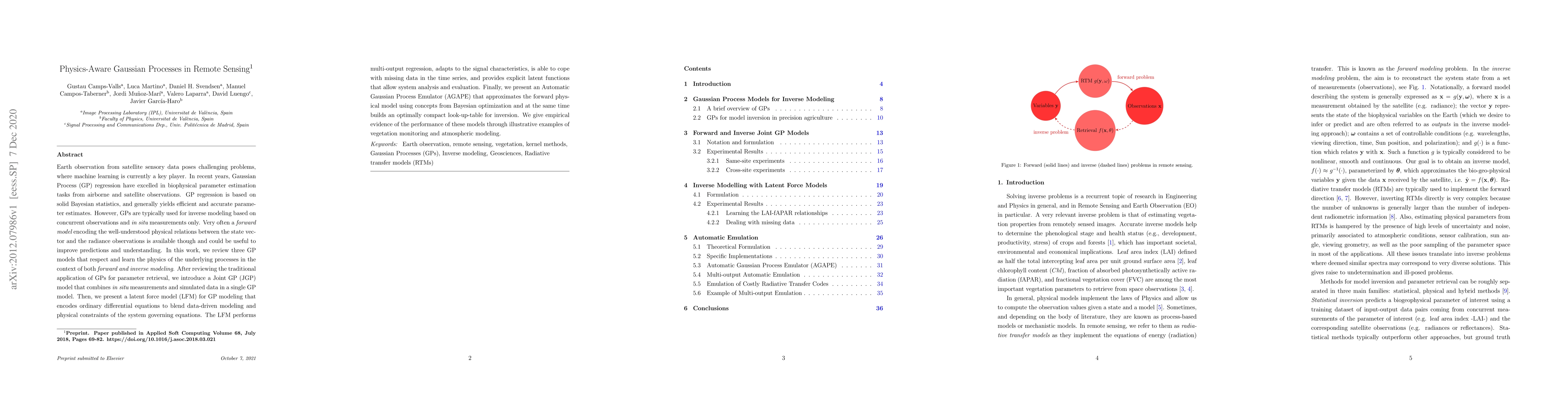
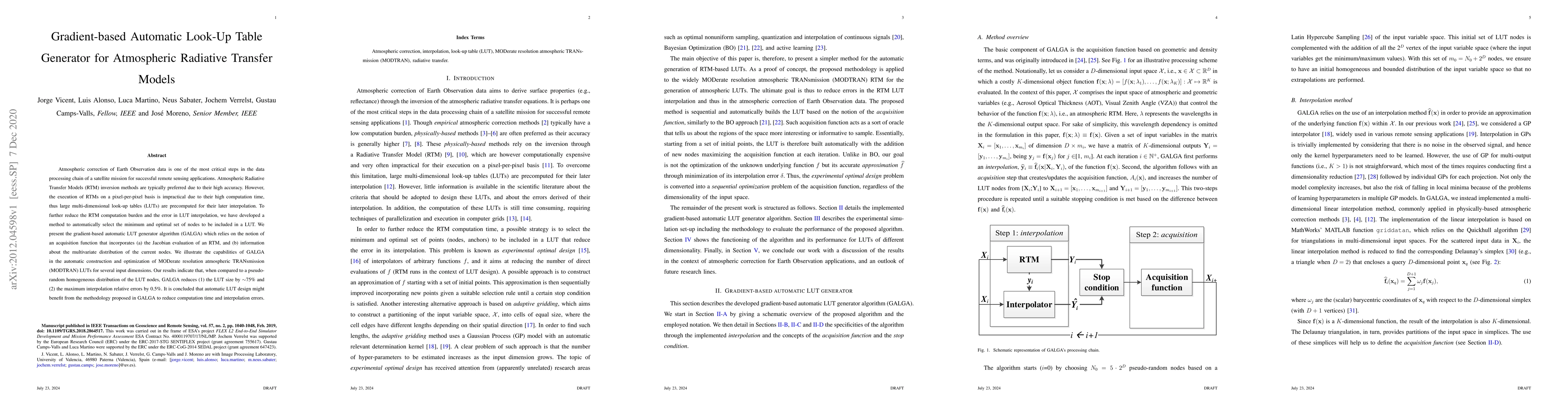
Earth observation from satellites offers the possibility to monitor our planet with unprecedented accuracy. Radiative transfer models (RTMs) encode the energy transfer through the atmosphere, and ar...
The synergistic combination of deep learning models and Earth observation promises significant advances to support the sustainable development goals (SDGs). New developments and a plethora of applic...
Learning the manifold structure of remote sensing images is of paramount relevance for modeling and understanding processes, as well as to encapsulate the high dimensionality in a reduced set of inf...
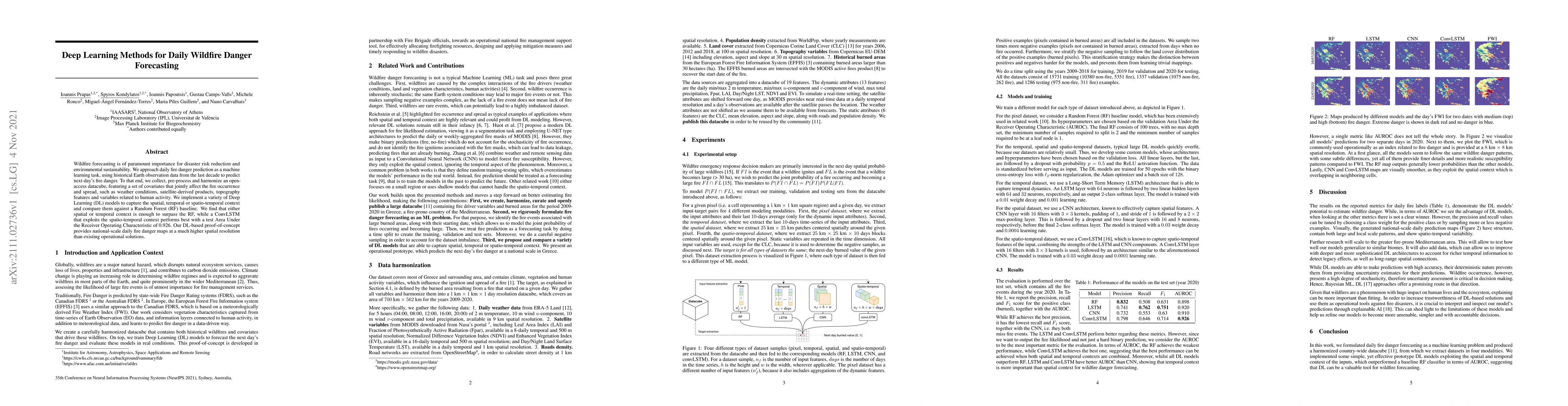
Wildfire forecasting is of paramount importance for disaster risk reduction and environmental sustainability. We approach daily fire danger prediction as a machine learning task, using historical Ea...
In many inference problems, the evaluation of complex and costly models is often required. In this context, Bayesian methods have become very popular in several fields over the last years, in order ...
Parameter retrieval and model inversion are key problems in remote sensing and Earth observation. Currently, different approximations exist: a direct, yet costly, inversion of radiative transfer mod...
The modelling of Earth observation data is a challenging problem, typically approached by either purely mechanistic or purely data-driven methods. Mechanistic models encode the domain knowledge and ...
We introduce a method for manifold alignment of different modalities (or domains) of remote sensing images. The problem is recurrent when a set of multitemporal, multisource, multisensor and multian...
In the last years we have witnessed the fields of geosciences and remote sensing and artificial intelligence to become closer. Thanks to both the massive availability of observational data, improved...
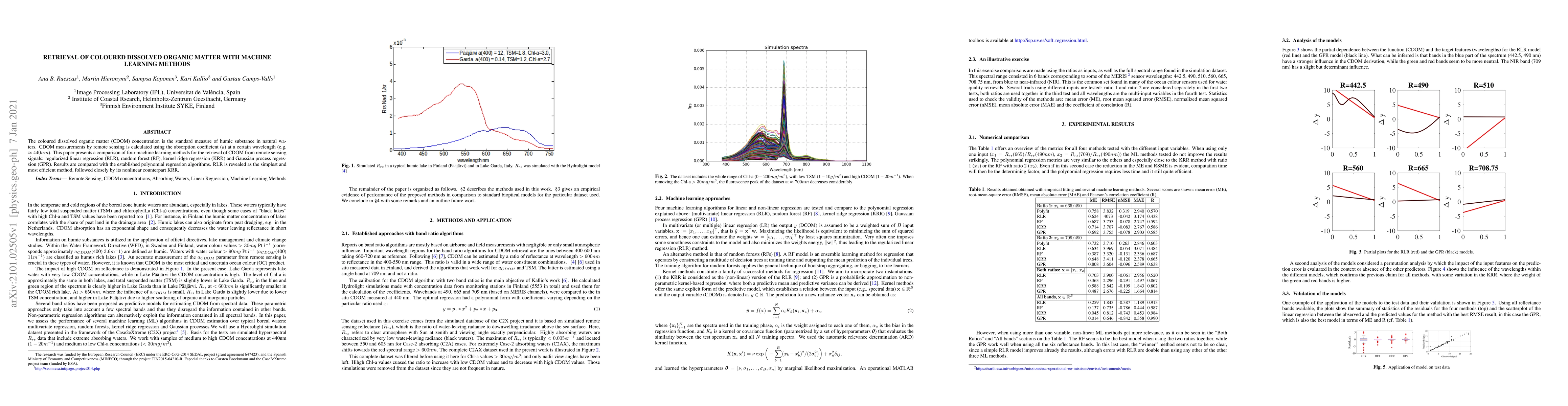
The coloured dissolved organic matter (CDOM) concentration is the standard measure of humic substance in natural waters. CDOM measurements by remote sensing is calculated using the absorption coeffi...
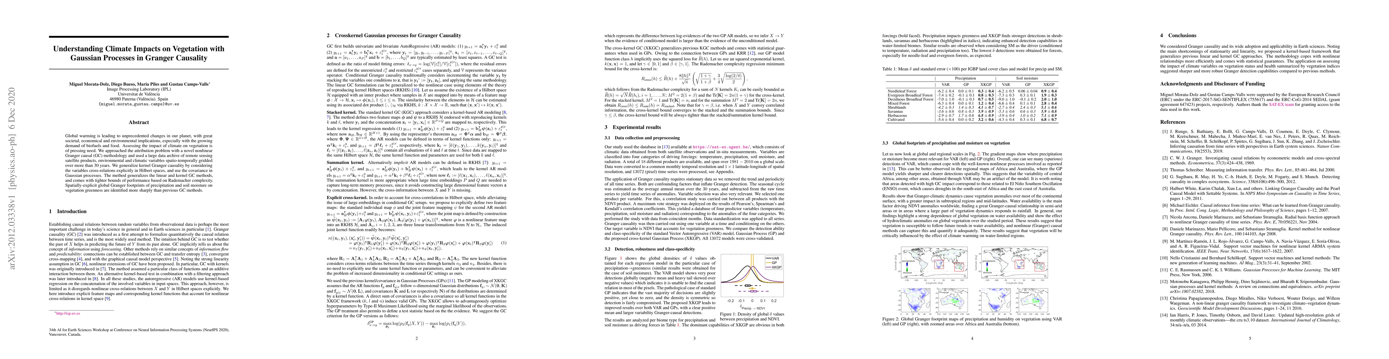
Establishing causal relations between random variables from observational data is perhaps the most important challenge in today's Science. In remote sensing and geosciences this is of special releva...
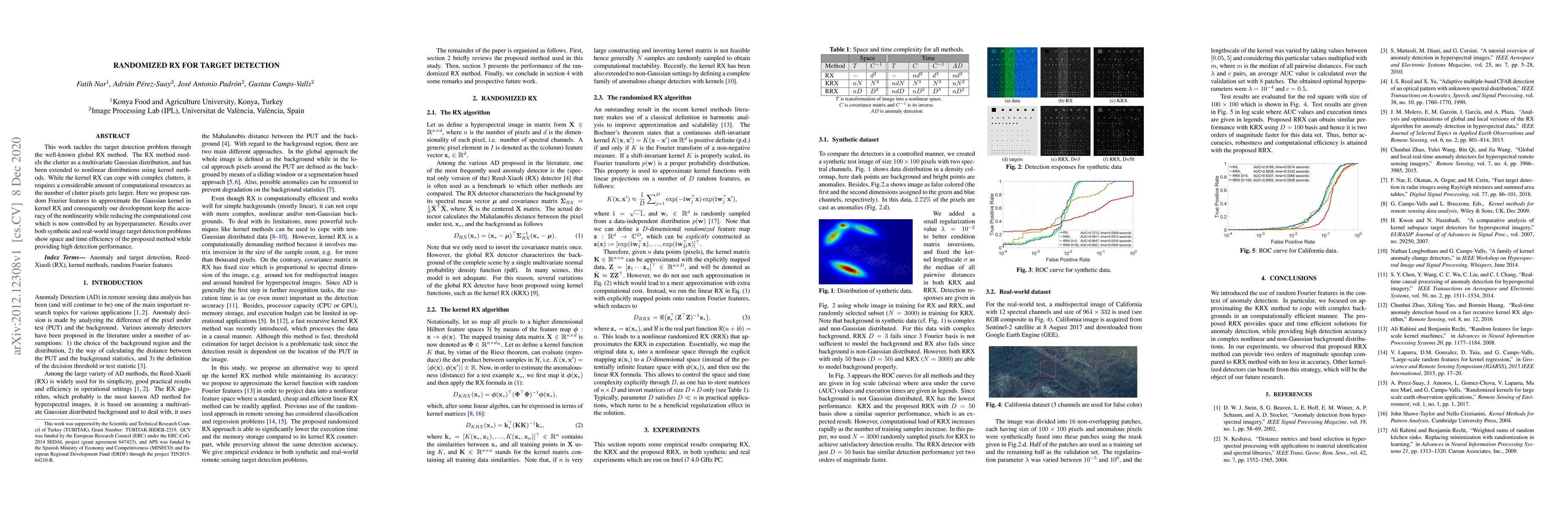
This work tackles the target detection problem through the well-known global RX method. The RX method models the clutter as a multivariate Gaussian distribution, and has been extended to nonlinear d...
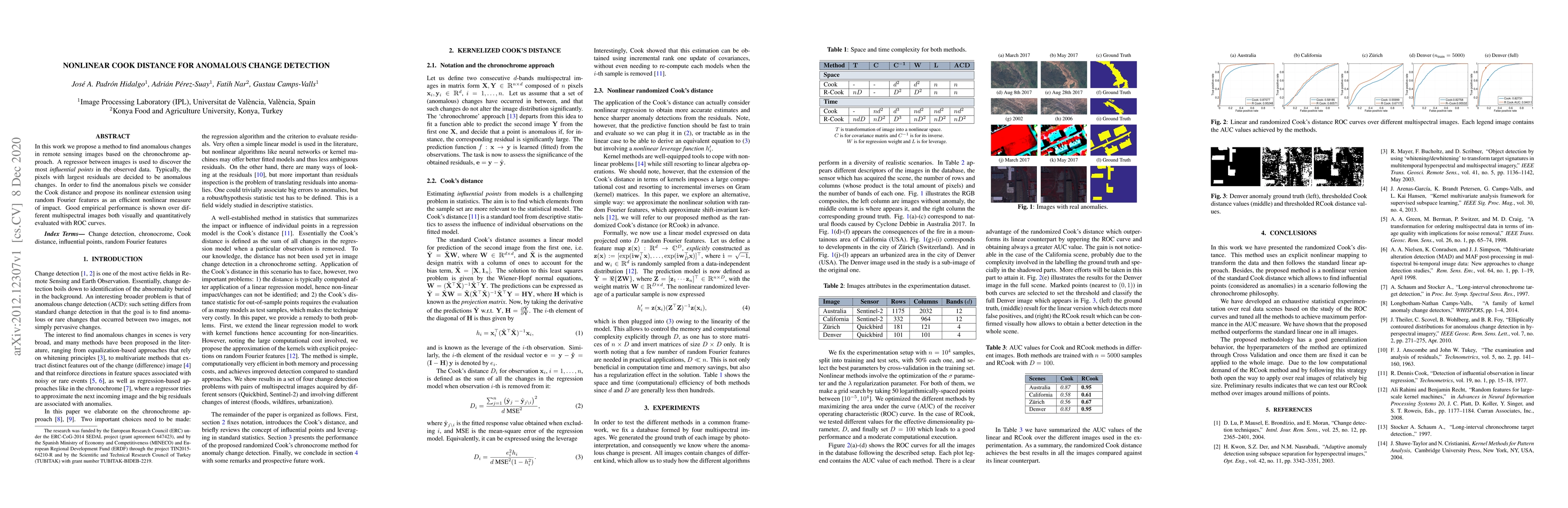
In this work we propose a method to find anomalous changes in remote sensing images based on the chronochrome approach. A regressor between images is used to discover the most {\em influential point...
Landmark recognition and matching is a critical step in many Image Navigation and Registration (INR) models for geostationary satellite services, as well as to maintain the geometric quality assessm...
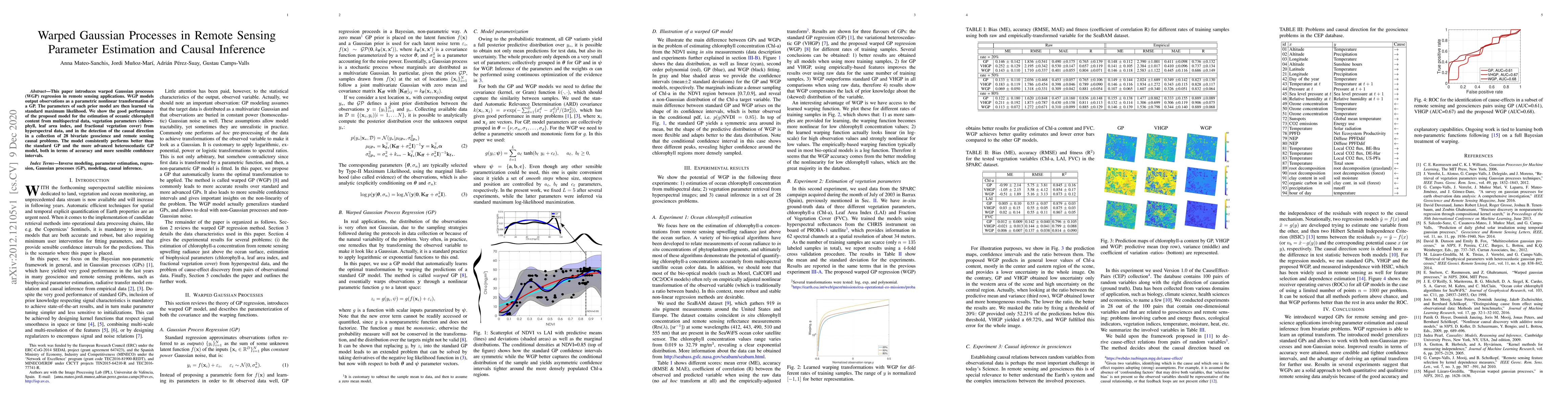
This paper introduces warped Gaussian processes (WGP) regression in remote sensing applications. WGP models output observations as a parametric nonlinear transformation of a GP. The parameters of su...
Satellite remote sensing has been widely used in the last decades for agricultural applications, {both for assessing vegetation condition and for subsequent yield prediction.} Existing remote sensin...
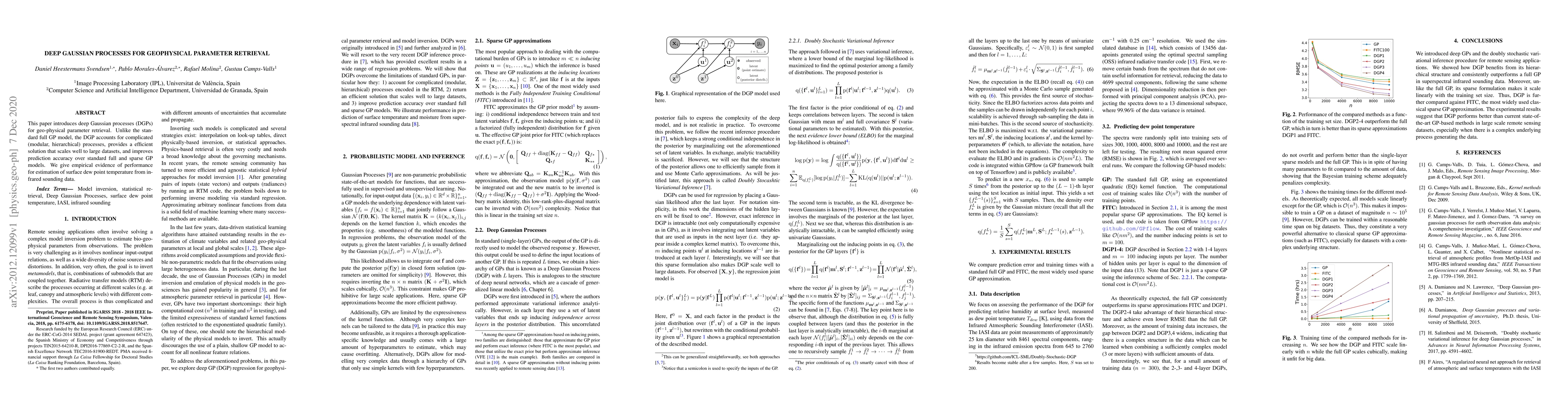
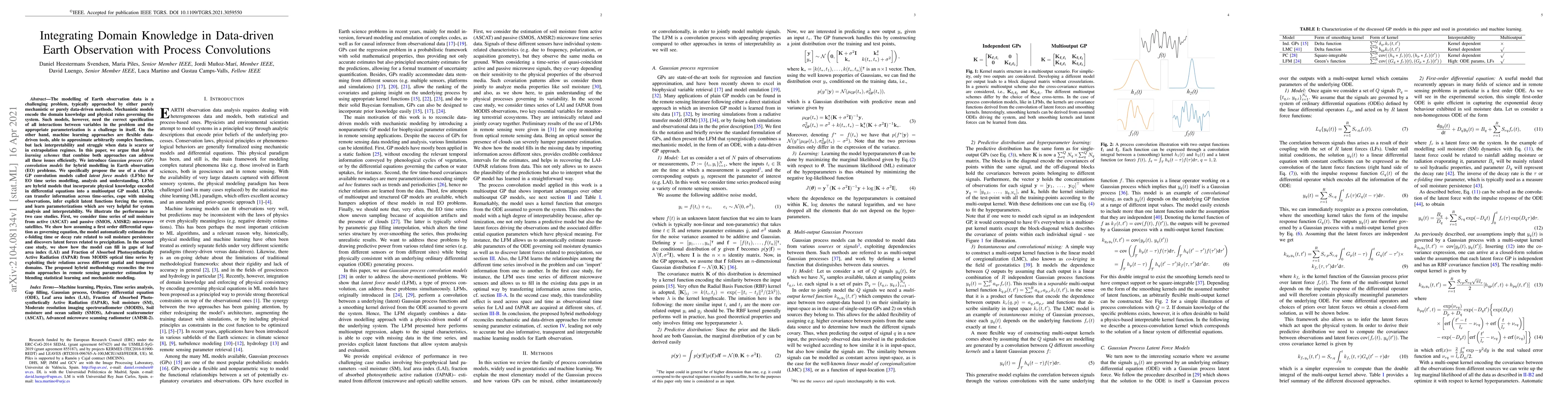
This paper introduces deep Gaussian processes (DGPs) for geophysical parameter retrieval. Unlike the standard full GP model, the DGP accounts for complicated (modular, hierarchical) processes, provi...
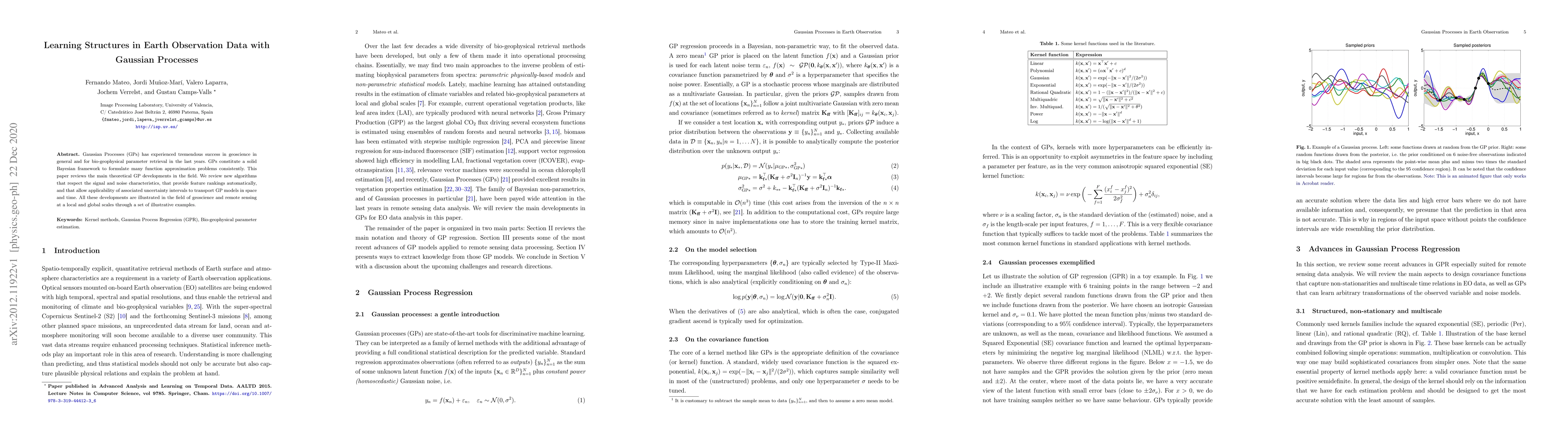
Gaussian Processes (GPs) has experienced tremendous success in geoscience in general and for bio-geophysical parameter retrieval in the last years. GPs constitute a solid Bayesian framework to formu...
Spatially and temporally explicit canopy water content (CWC) data are important for monitoring vegetation status, and constitute essential information for studying ecosystem-climate interactions. De...
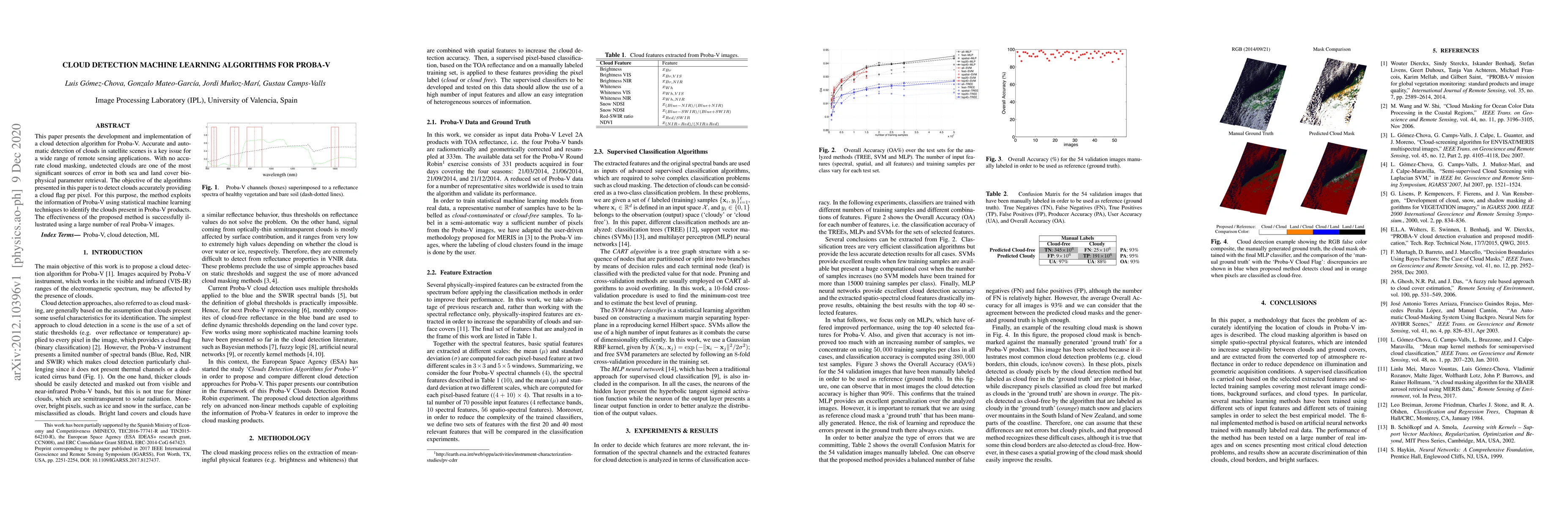
This paper presents the development and implementation of a cloud detection algorithm for Proba-V. Accurate and automatic detection of clouds in satellite scenes is a key issue for a wide range of r...
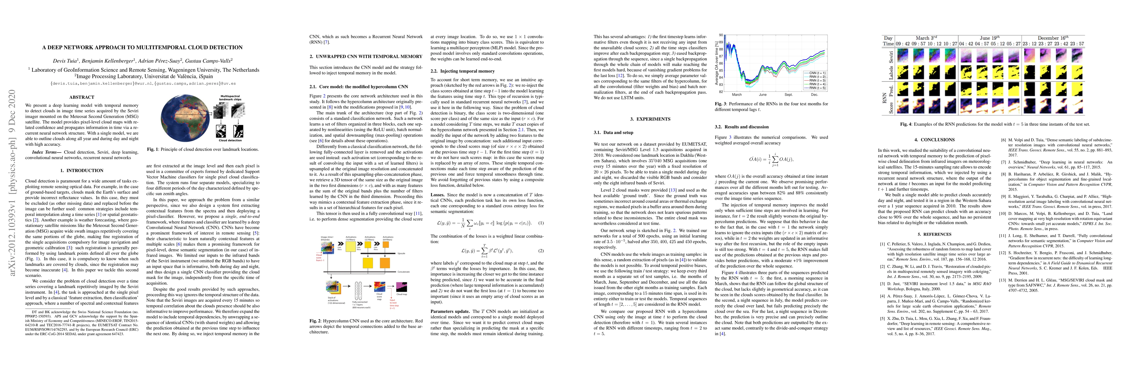
We present a deep learning model with temporal memory to detect clouds in image time series acquired by the Seviri imager mounted on the Meteosat Second Generation (MSG) satellite. The model provide...
Computationally expensive Radiative Transfer Models (RTMs) are widely used} to realistically reproduce the light interaction with the Earth surface and atmosphere. Because these models take long pro...
With current and upcoming imaging spectrometers, automated band analysis techniques are needed to enable efficient identification of most informative bands to facilitate optimized processing of spec...
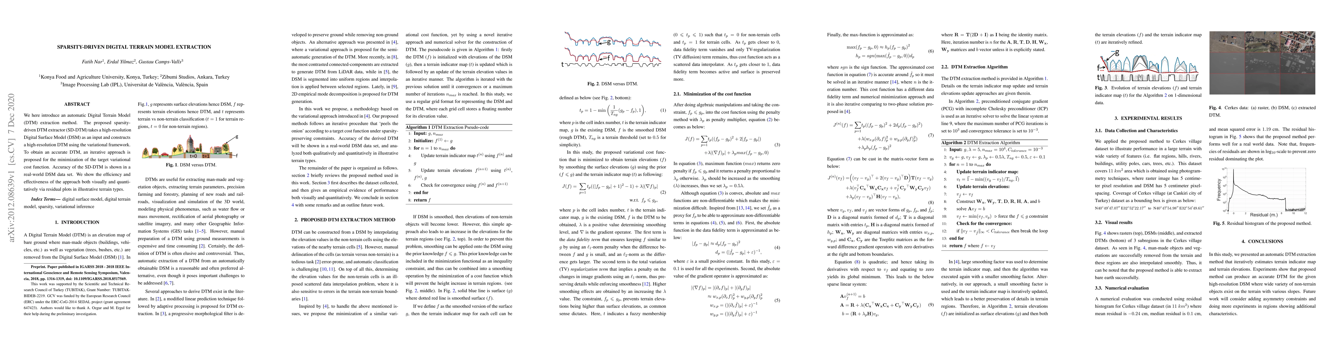
We here introduce an automatic Digital Terrain Model (DTM) extraction method. The proposed sparsity-driven DTM extractor (SD-DTM) takes a high-resolution Digital Surface Model (DSM) as an input and ...
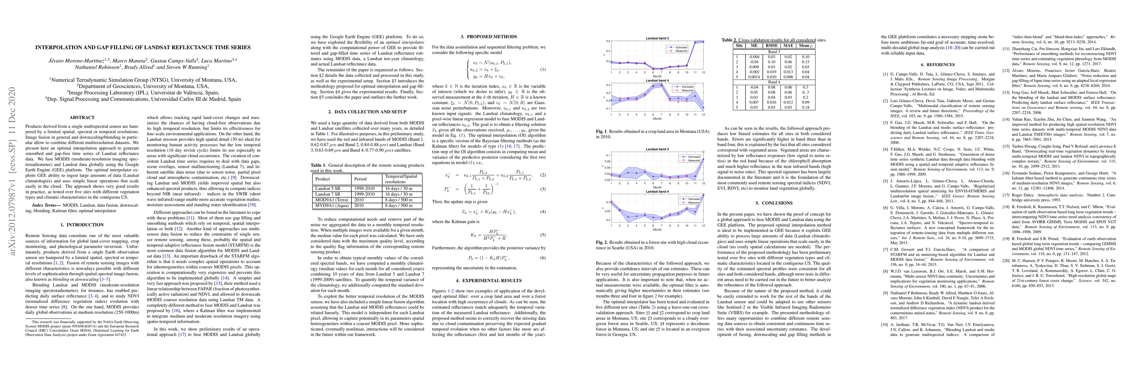
Products derived from a single multispectral sensor are hampered by a limited spatial, spectral or temporal resolutions. Image fusion in general and downscaling/blending in particular allow to combi...
Earth observation from satellite sensory data poses challenging problems, where machine learning is currently a key player. In recent years, Gaussian Process (GP) regression has excelled in biophysi...
This paper introduces a modular processing chain to derive global high-resolution maps of leaf traits. In particular, we present global maps at 500 m resolution of specific leaf area, leaf dry matte...
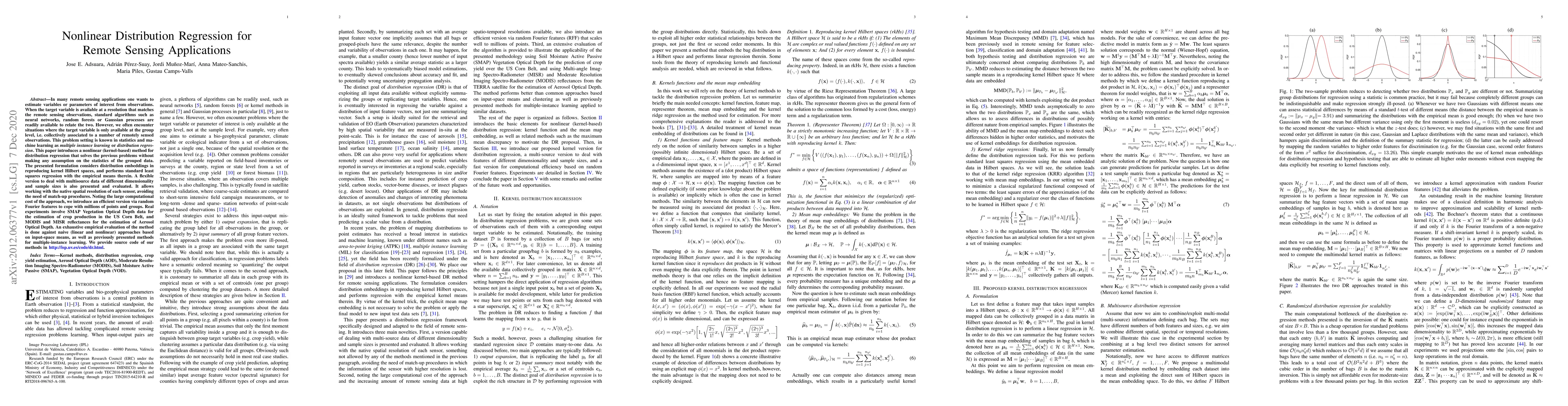
In many remote sensing applications one wants to estimate variables or parameters of interest from observations. When the target variable is available at a resolution that matches the remote sensing...
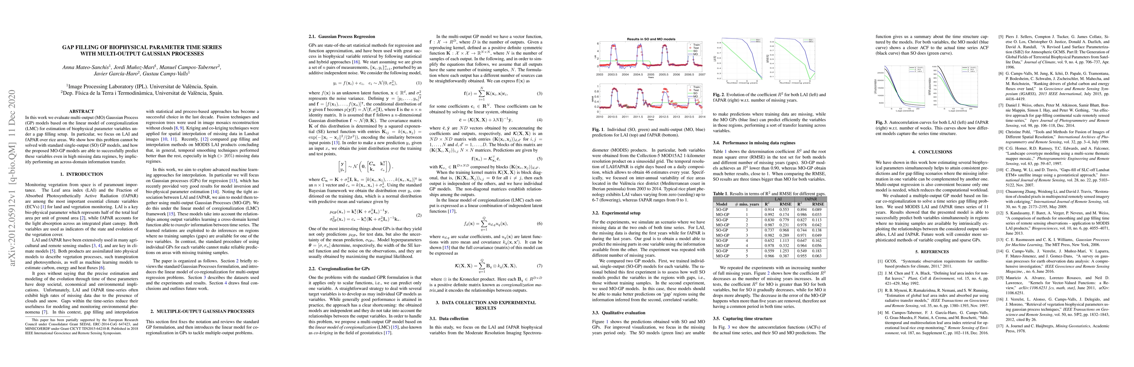
In this work we evaluate multi-output (MO) Gaussian Process (GP) models based on the linear model of coregionalization (LMC) for estimation of biophysical parameter variables under a gap filling set...
Developing accurate models of crop stress, phenology and productivity is of paramount importance, given the increasing need of food. Earth observation remote sensing data provides a unique source of...

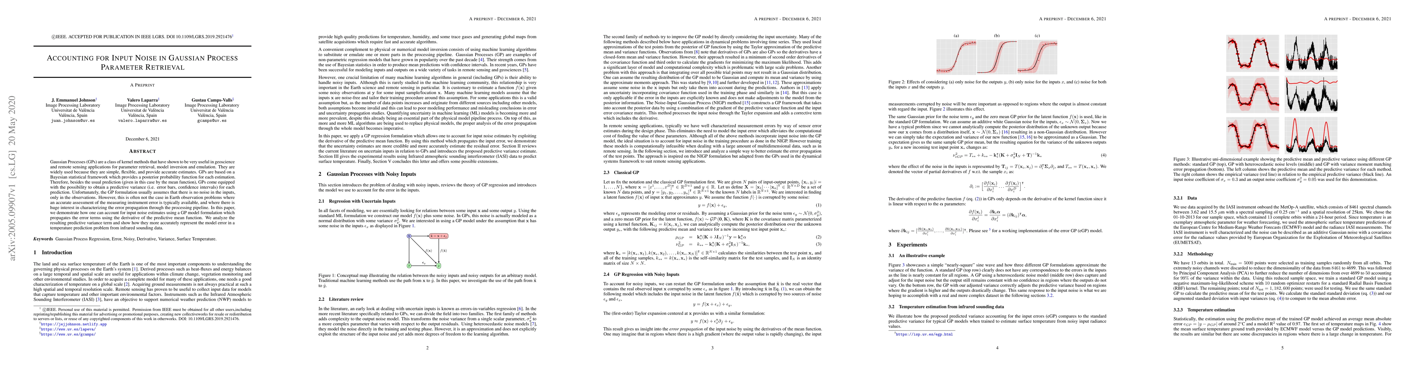
In this paper we present a combined strategy for the retrieval of atmospheric profiles from infrared sounders. The approach considers the spatial information and a noise-dependent dimensionality red...
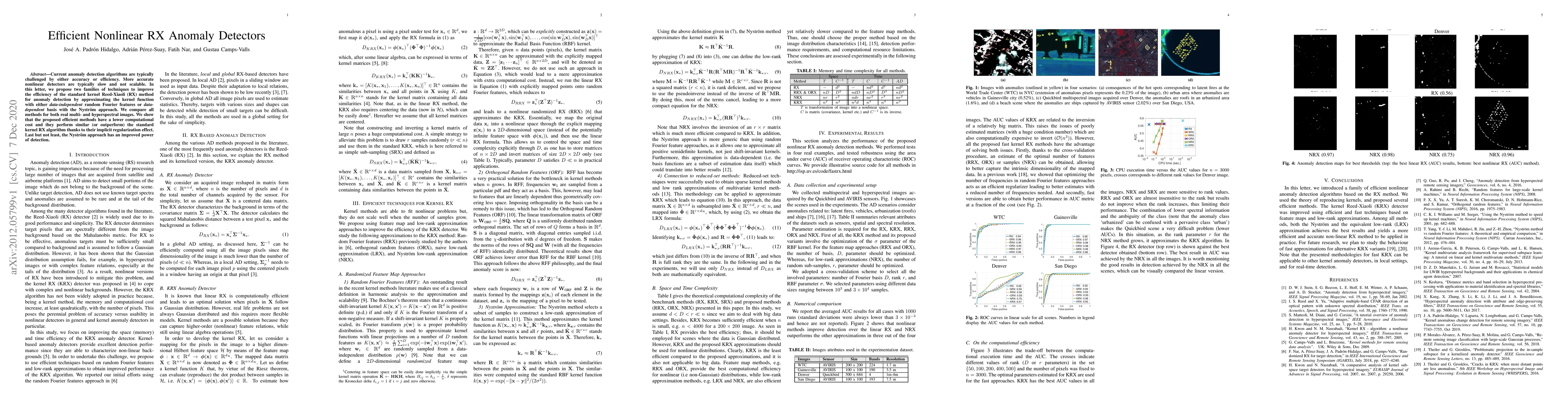
Current anomaly detection algorithms are typically challenged by either accuracy or efficiency. More accurate nonlinear detectors are typically slow and not scalable. In this letter, we propose two ...
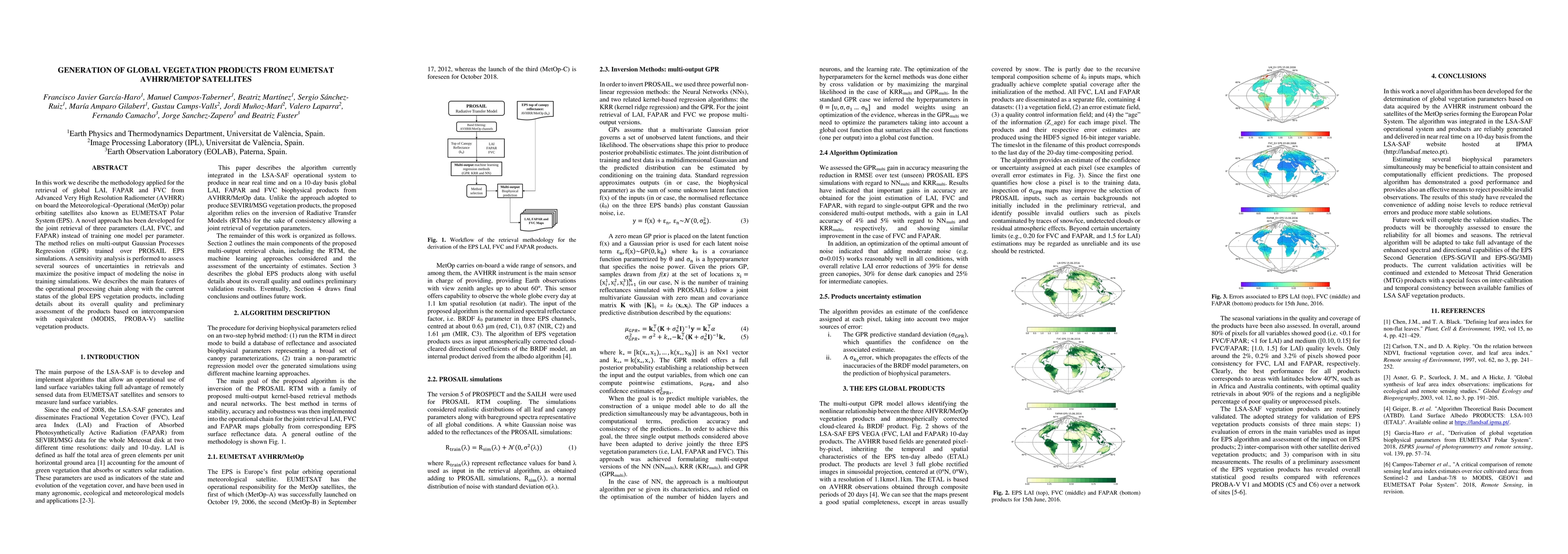
We describe the methodology applied for the retrieval of global LAI, FAPAR and FVC from Advanced Very High Resolution Radiometer (AVHRR) onboard the Meteorological-Operational (MetOp) polar orbiting...
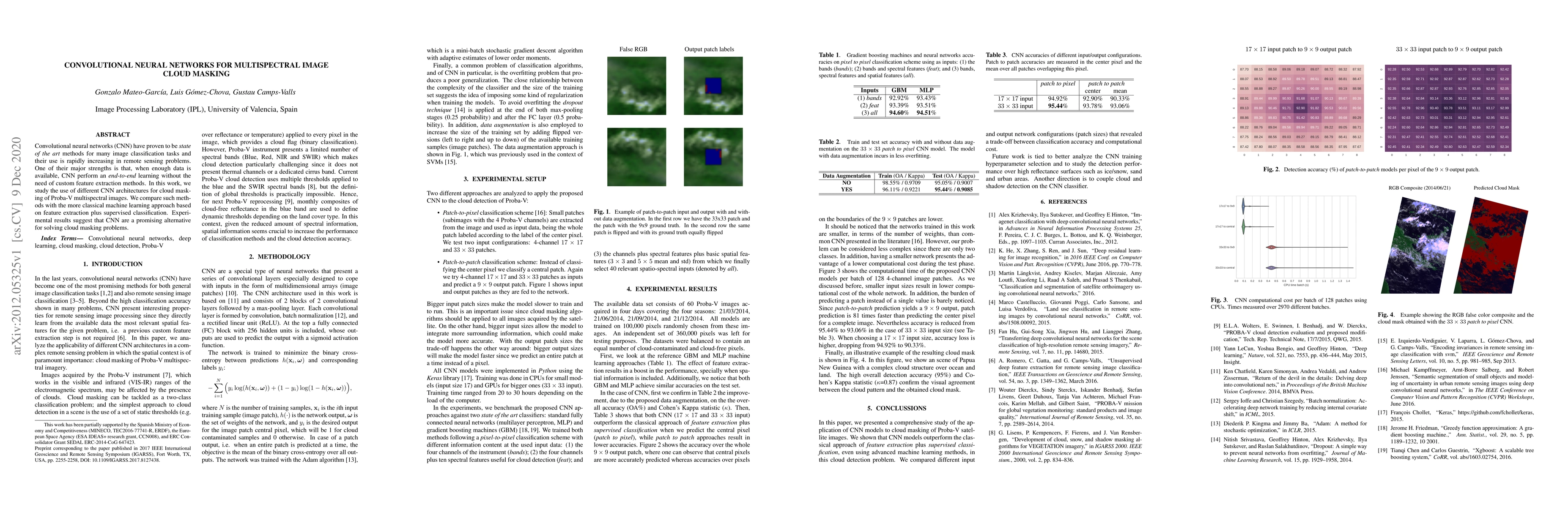
Convolutional neural networks (CNN) have proven to be state of the art methods for many image classification tasks and their use is rapidly increasing in remote sensing problems. One of their major ...
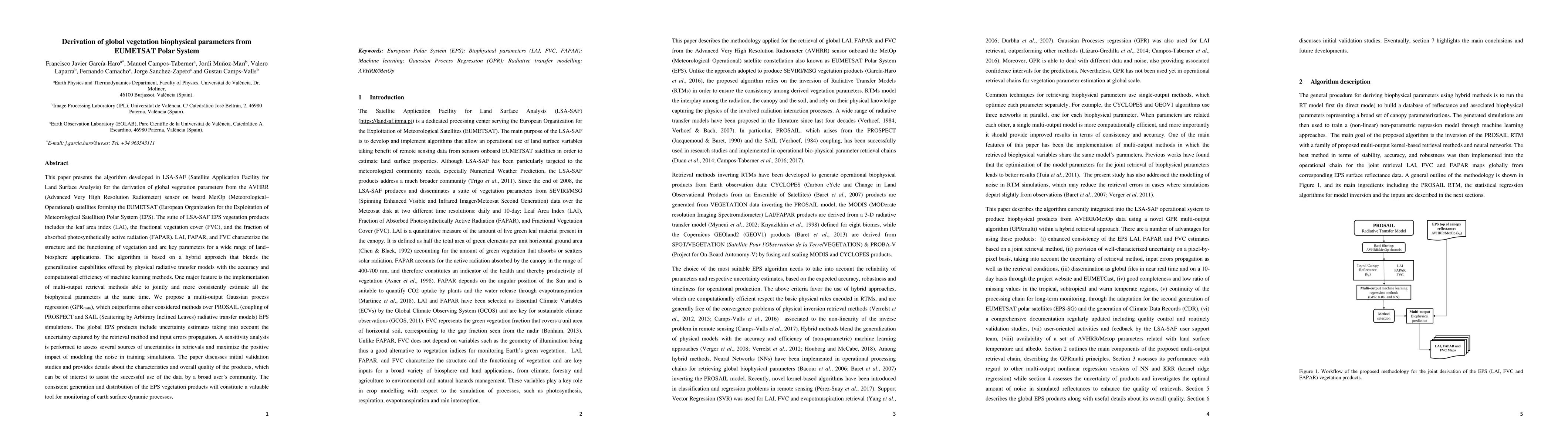
This paper presents the algorithm developed in LSA-SAF (Satellite Application Facility for Land Surface Analysis) for the derivation of global vegetation parameters from the AVHRR (Advanced Very Hig...
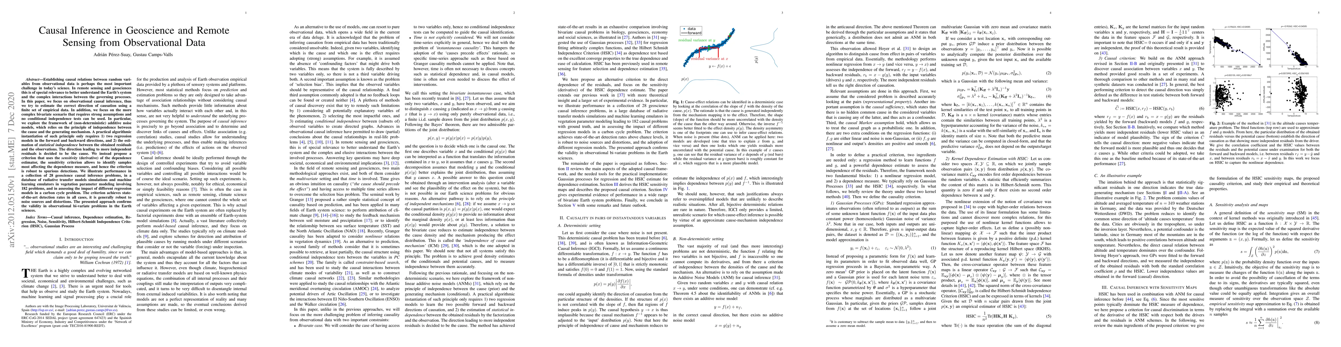
Establishing causal relations between random variables from observational data is perhaps the most important challenge in today's \blue{science}. In remote sensing and geosciences this is of special...
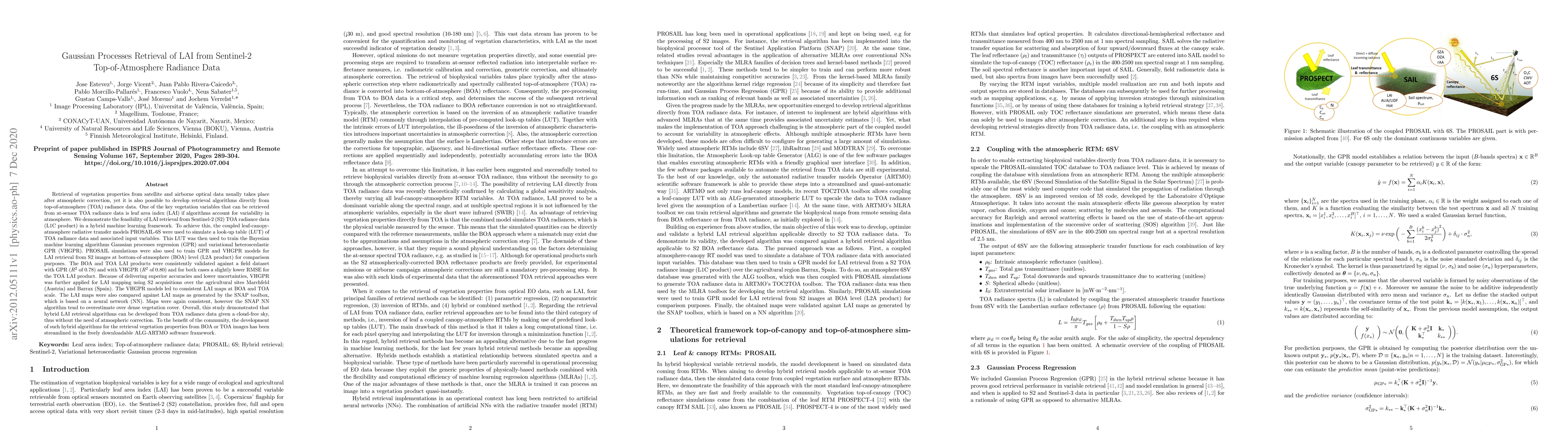
Retrieval of vegetation properties from satellite and airborne optical data usually takes place after atmospheric correction, yet it is also possible to develop retrieval algorithms directly from to...
Hyperspectral acquisitions have proven to be the most informative Earth observation data source for the estimation of nitrogen (N) content, which is the main limiting nutrient for plant growth and t...
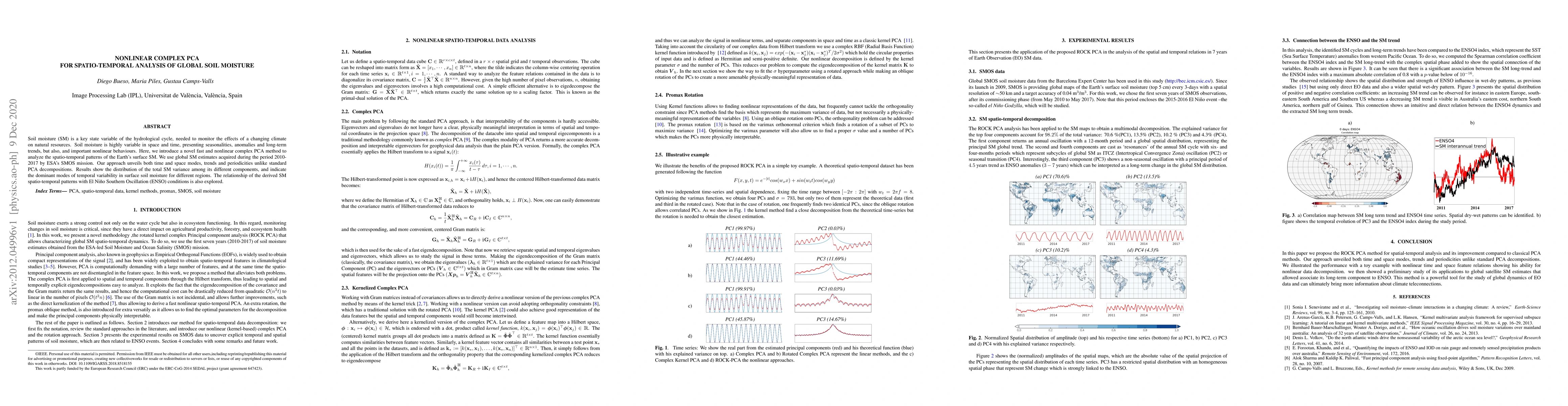
Soil moisture (SM) is a key state variable of the hydrological cycle, needed to monitor the effects of a changing climate on natural resources. Soil moisture is highly variable in space and time, pr...
Gaussian Processes (GPs) are a class of kernel methods that have shown to be very useful in geoscience applications. They are widely used because they are simple, flexible and provide very accurate ...
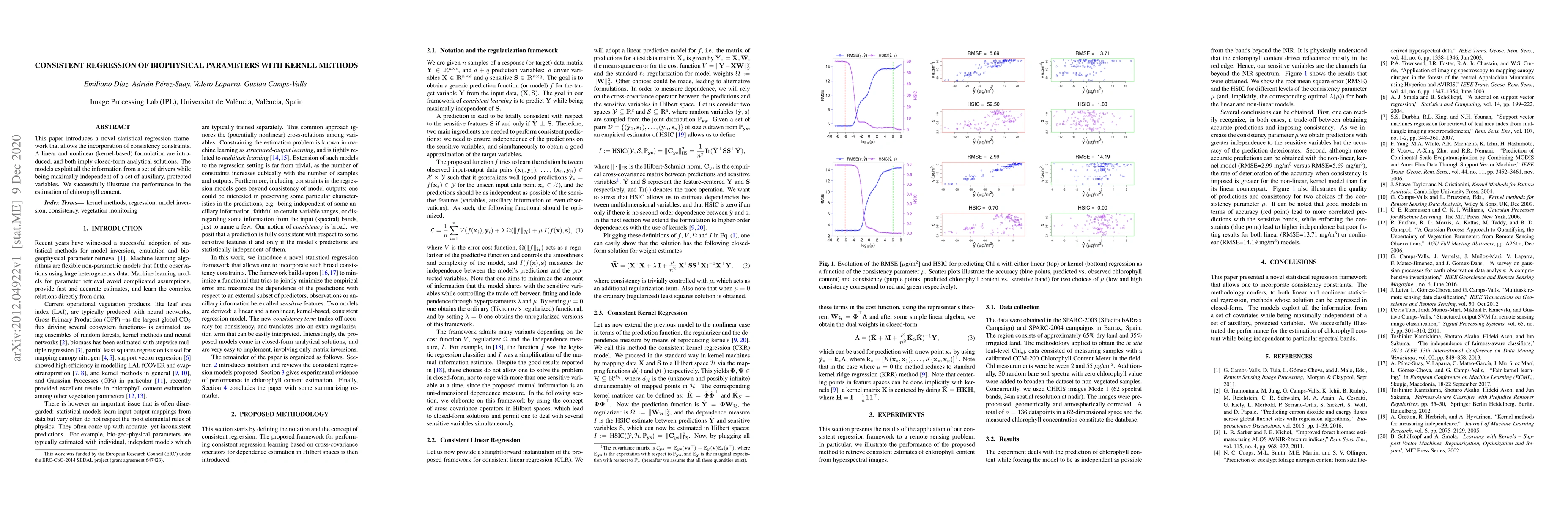
This paper introduces a novel statistical regression framework that allows the incorporation of consistency constraints. A linear and nonlinear (kernel-based) formulation are introduced, and both im...
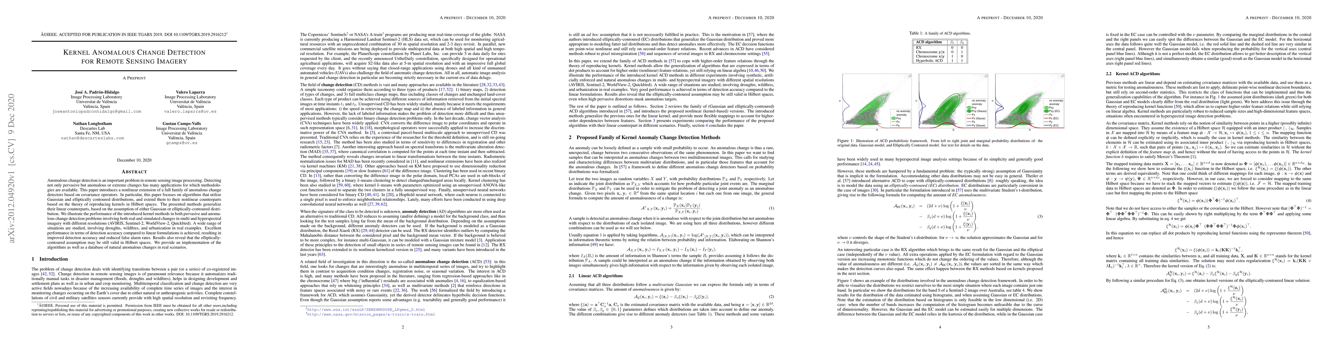
Anomalous change detection (ACD) is an important problem in remote sensing image processing. Detecting not only pervasive but also anomalous or extreme changes has many applications for which method...
Atmospheric correction of Earth Observation data is one of the most critical steps in the data processing chain of a satellite mission for successful remote sensing applications. Atmospheric Radiati...
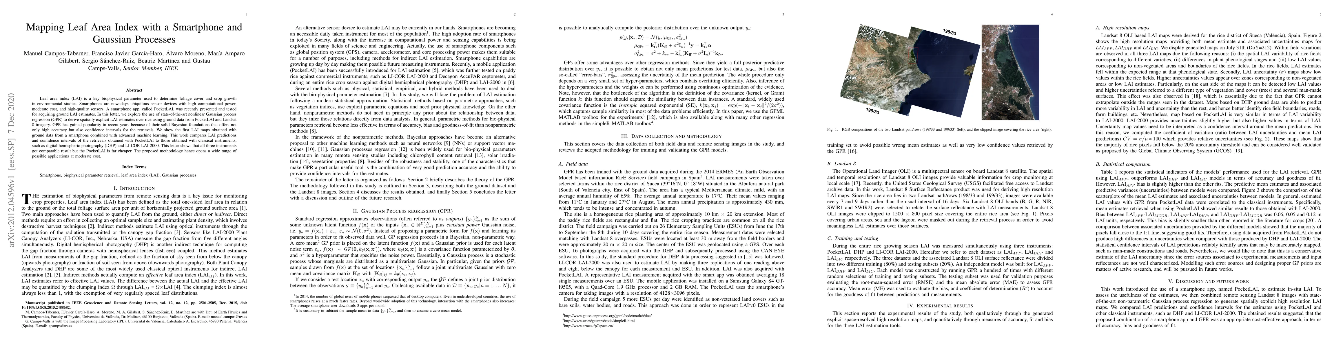
Leaf area index (LAI) is a key biophysical parameter used to determine foliage cover and crop growth in environmental studies. Smartphones are nowadays ubiquitous sensor devices with high computatio...
An unprecedented spectroscopic data stream will soon become available with forthcoming Earth-observing satellite missions equipped with imaging spectroradiometers. This data stream will open up a va...
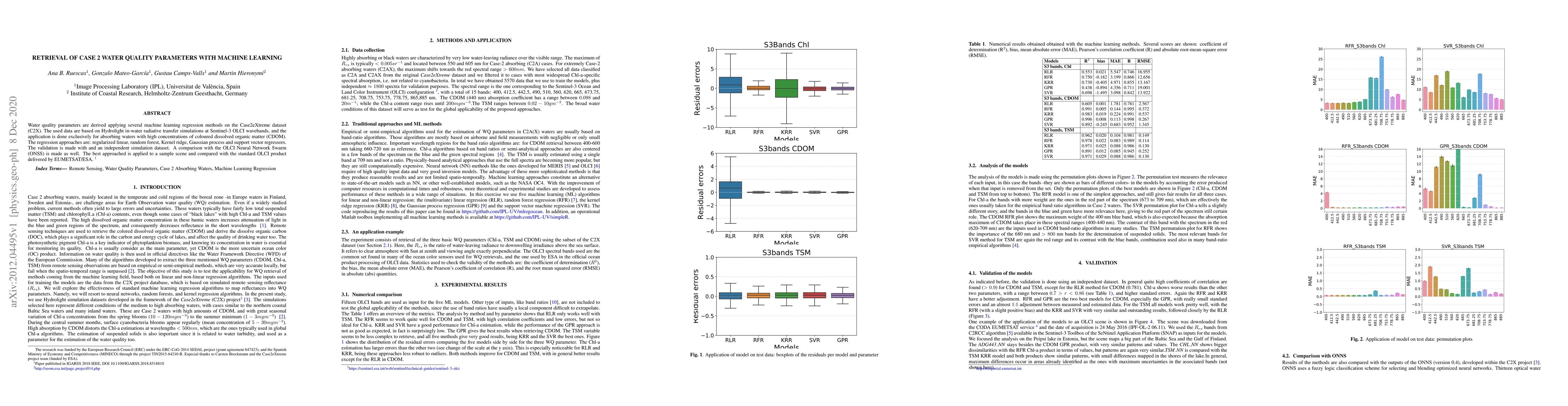
Water quality parameters are derived applying several machine learning regression methods on the Case2eXtreme dataset (C2X). The used data are based on Hydrolight in-water radiative transfer simulat...
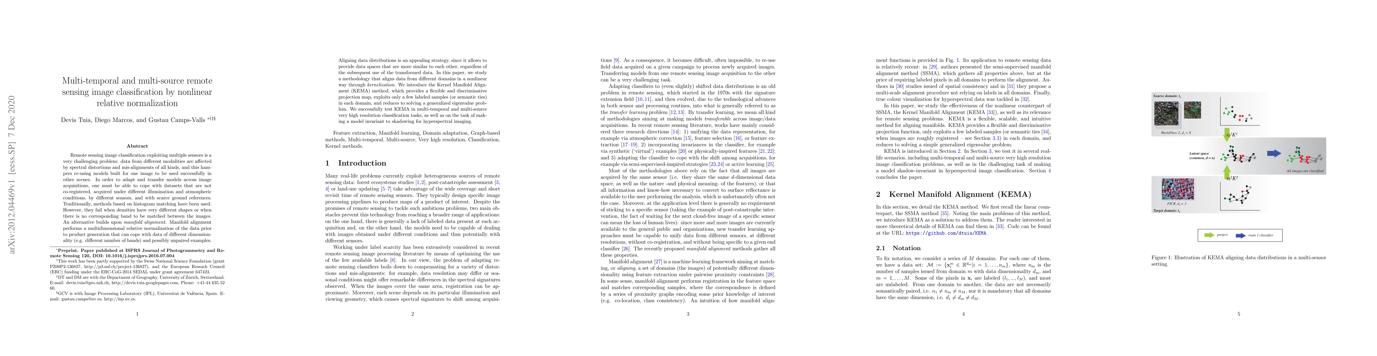
Remote sensing image classification exploiting multiple sensors is a very challenging problem: data from different modalities are affected by spectral distortions and mis-alignments of all kinds, an...
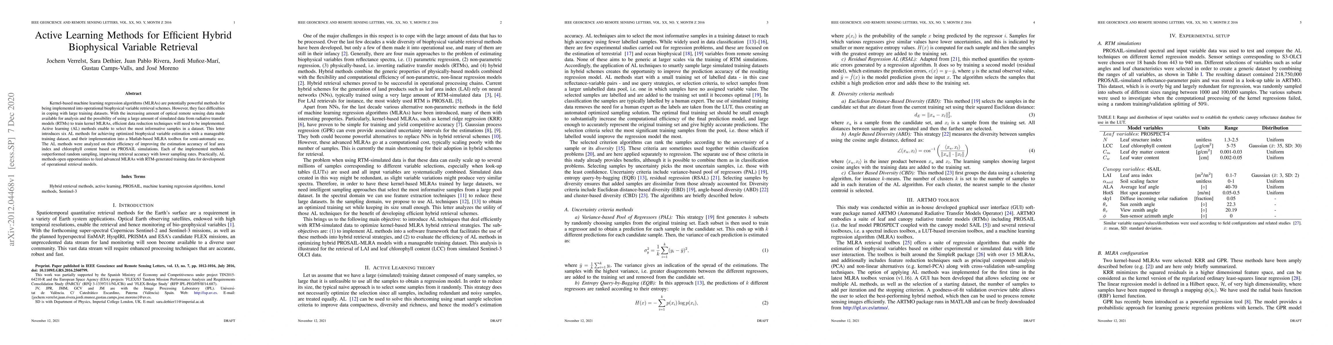
Kernel-based machine learning regression algorithms (MLRAs) are potentially powerful methods for being implemented into operational biophysical variable retrieval schemes. However, they face difficu...
Dealing with land cover classification of the new image sources has also turned to be a complex problem requiring large amount of memory and processing time. In order to cope with these problems, st...
Global warming is leading to unprecedented changes in our planet, with great societal, economical and environmental implications, especially with the growing demand of biofuels and food. Assessing t...
The availability of satellite optical information is often hampered by the natural presence of clouds, which can be problematic for many applications. Persistent clouds over agricultural fields can ...
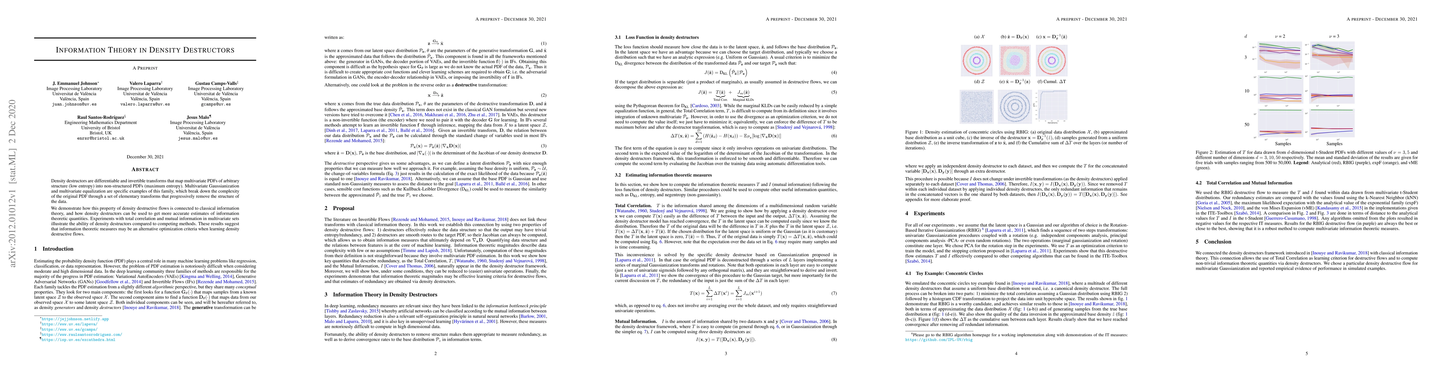
Density destructors are differentiable and invertible transforms that map multivariate PDFs of arbitrary structure (low entropy) into non-structured PDFs (maximum entropy). Multivariate Gaussianizat...
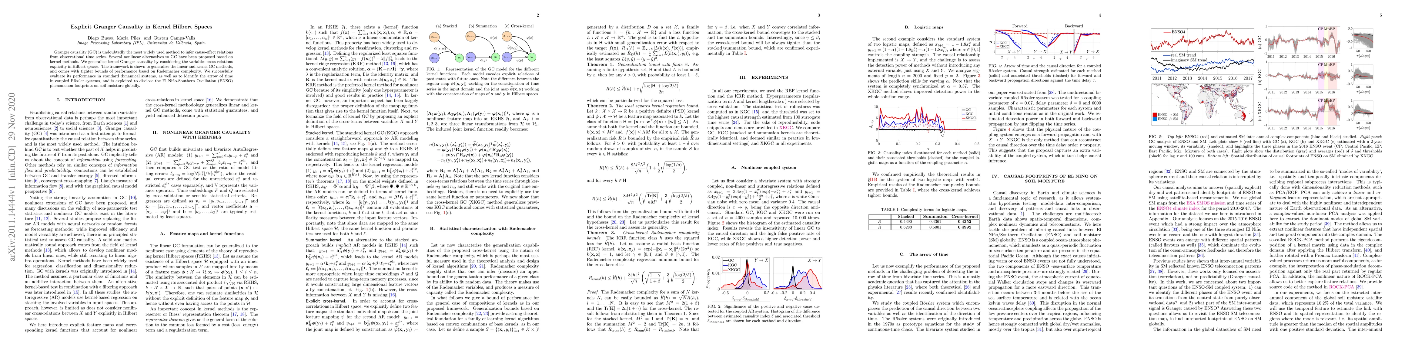
Granger causality (GC) is undoubtedly the most widely used method to infer cause-effect relations from observational time series. Several nonlinear alternatives to GC have been proposed based on ker...
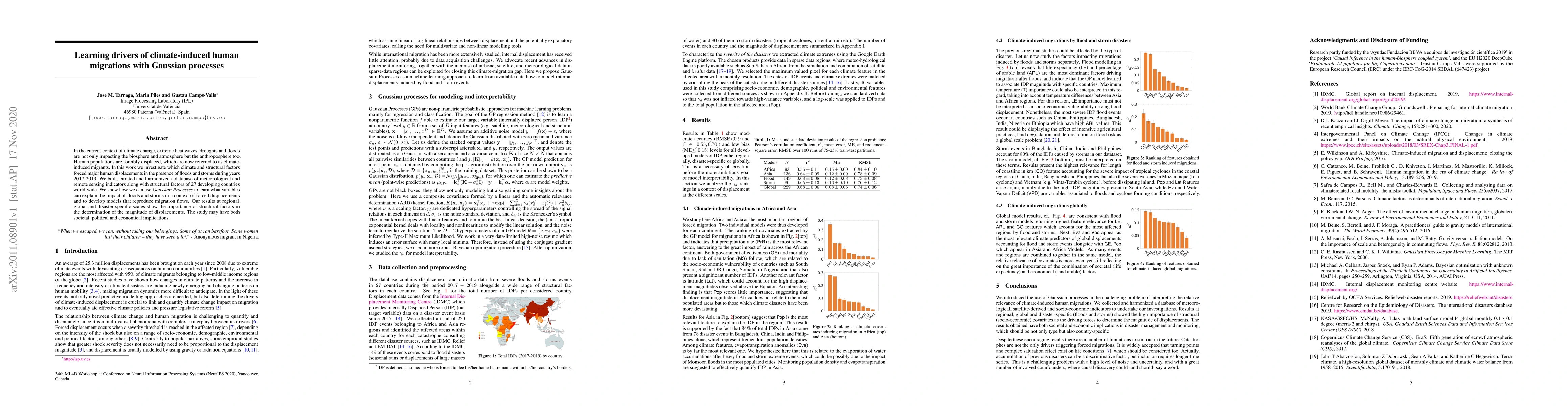
In the current context of climate change, extreme heatwaves, droughts, and floods are not only impacting the biosphere and atmosphere but the anthroposphere too. Human populations are forcibly displ...
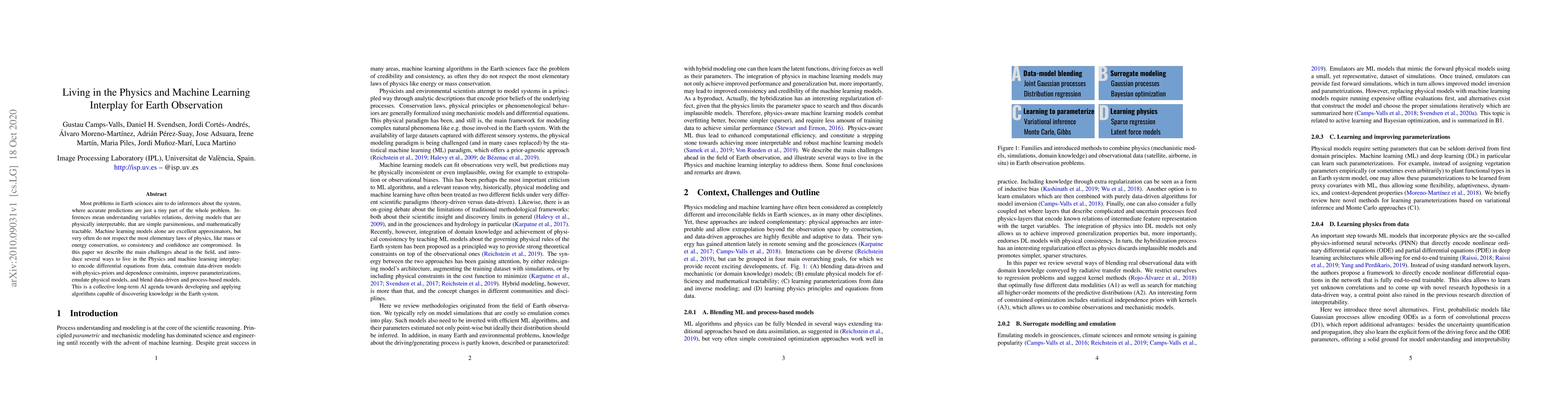
Most problems in Earth sciences aim to do inferences about the system, where accurate predictions are just a tiny part of the whole problem. Inferences mean understanding variables relations, derivi...
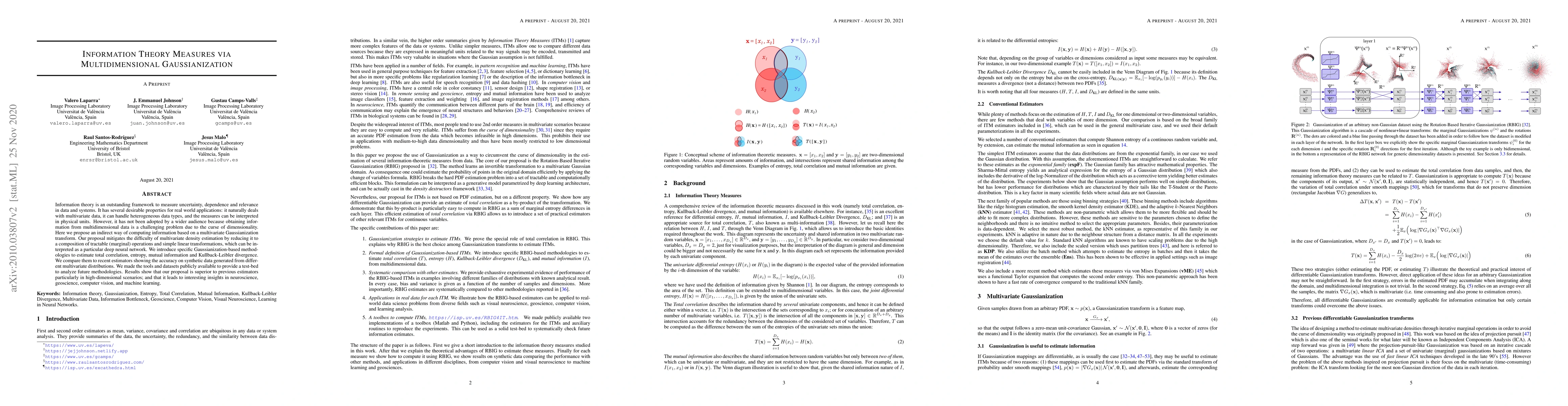
Information theory is an outstanding framework to measure uncertainty, dependence and relevance in data and systems. It has several desirable properties for real world applications: it naturally dea...
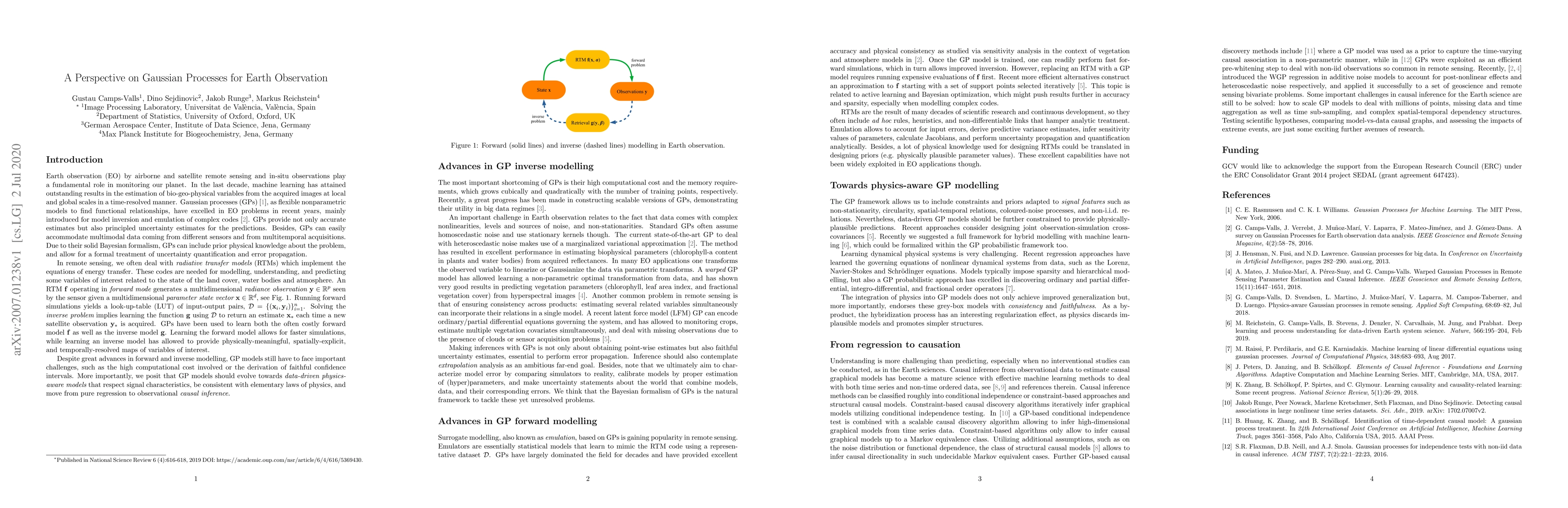
Earth observation (EO) by airborne and satellite remote sensing and in-situ observations play a fundamental role in monitoring our planet. In the last decade, machine learning and Gaussian processes...
Gaussian processes (GPs) are a class of Kernel methods that have shown to be very useful in geoscience and remote sensing applications for parameter retrieval, model inversion, and emulation. They a...
Remote sensing observations, products and simulations are fundamental sources of information to monitor our planet and its climate variability. Uncovering the main modes of spatial and temporal vari...
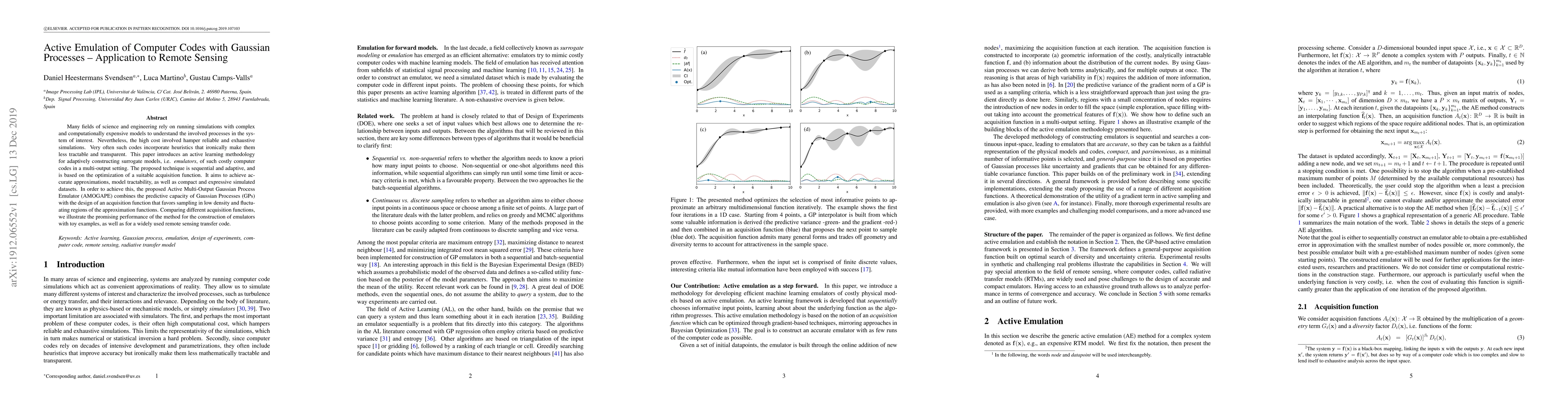
Many fields of science and engineering rely on running simulations with complex and computationally expensive models to understand the involved processes in the system of interest. Nevertheless, the...
Current adoption of machine learning in industrial, societal and economical activities has raised concerns about the fairness, equity and ethics of automated decisions. Predictive models are often d...
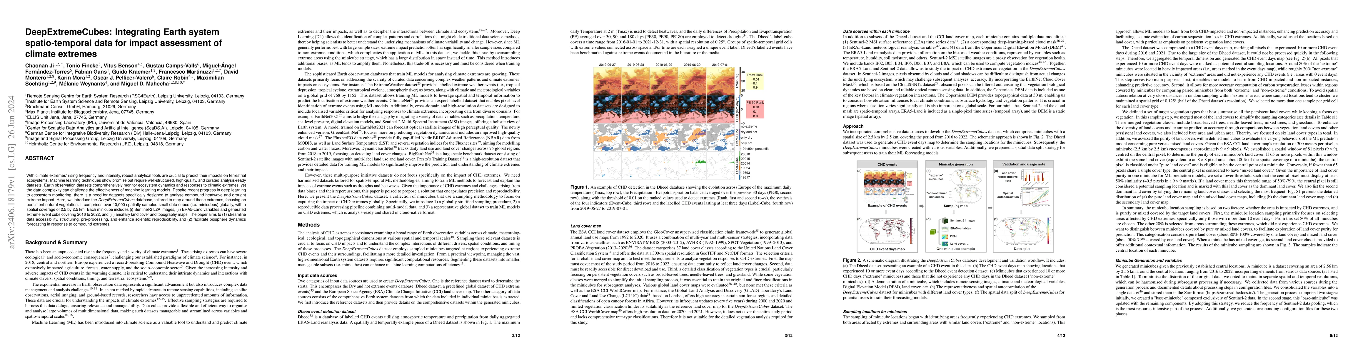
Recent advancements in Earth system science have been marked by the exponential increase in the availability of diverse, multivariate datasets characterised by moderate to high spatio-temporal resolut...
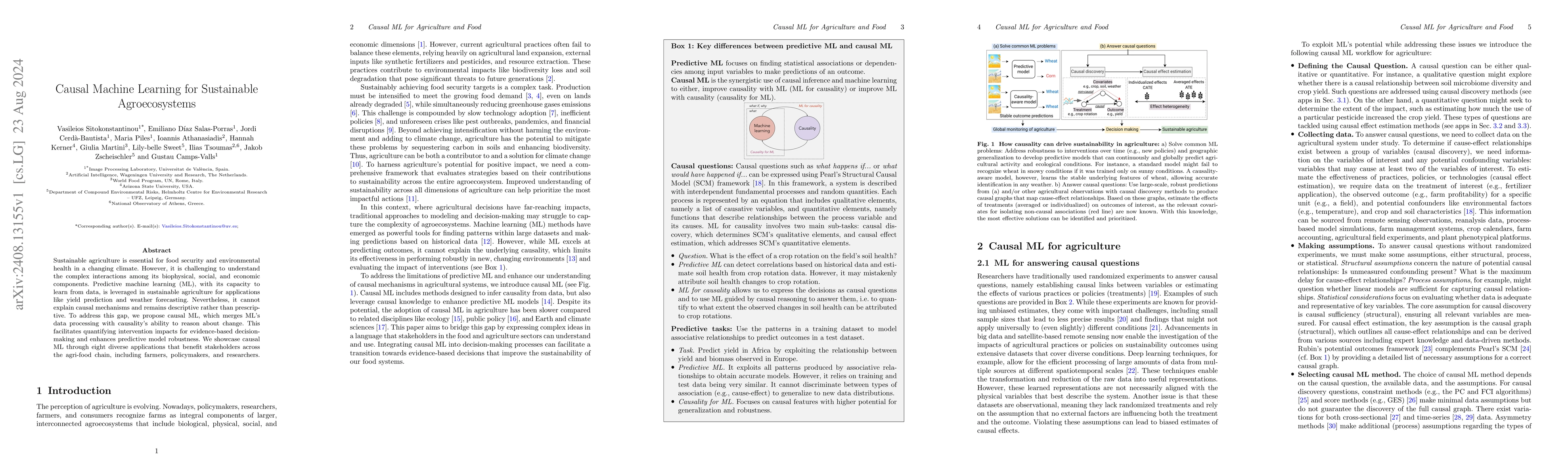
In a changing climate, sustainable agriculture is essential for food security and environmental health. However, it is challenging to understand the complex interactions among its biophysical, social,...
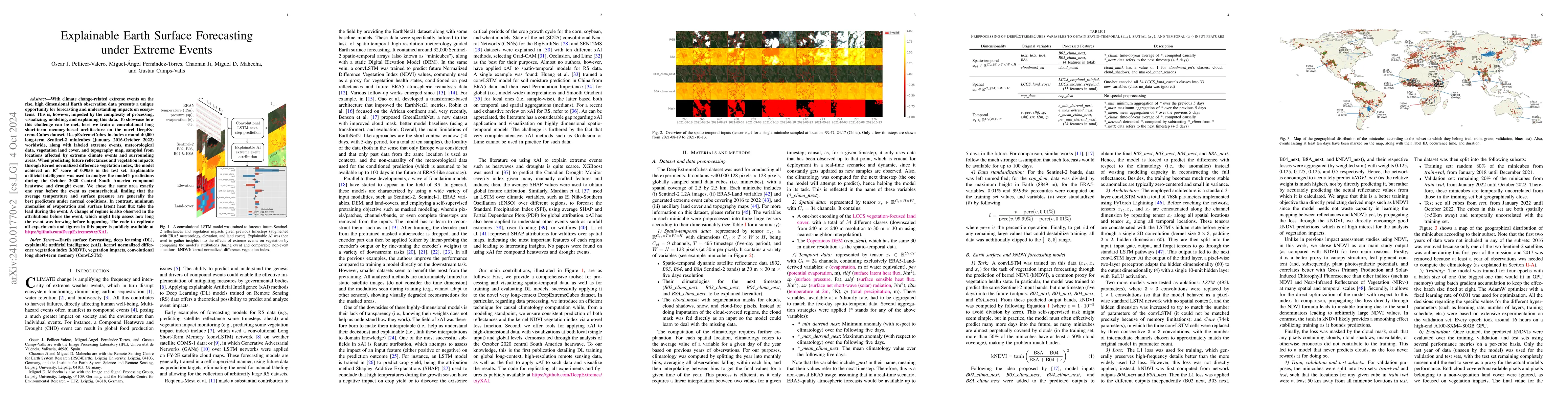
With climate change-related extreme events on the rise, high dimensional Earth observation data presents a unique opportunity for forecasting and understanding impacts on ecosystems. This is, however,...
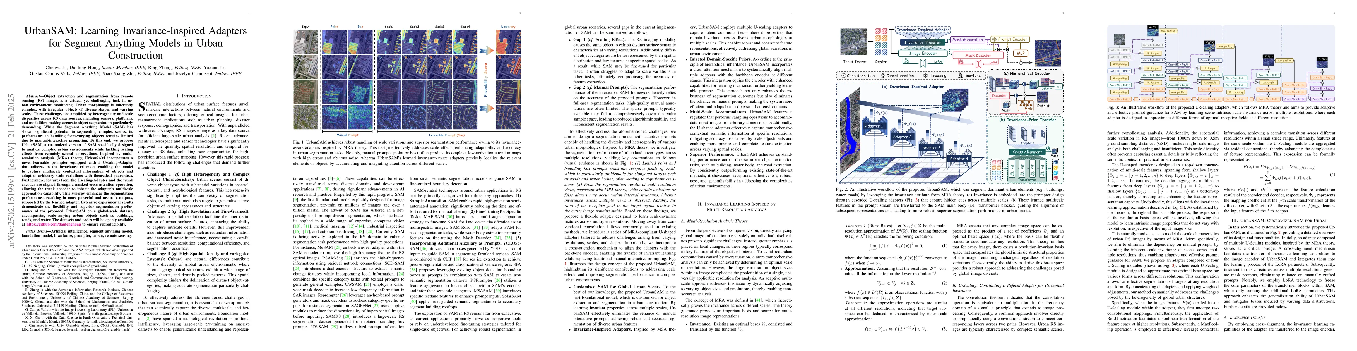
Object extraction and segmentation from remote sensing (RS) images is a critical yet challenging task in urban environment monitoring. Urban morphology is inherently complex, with irregular objects of...
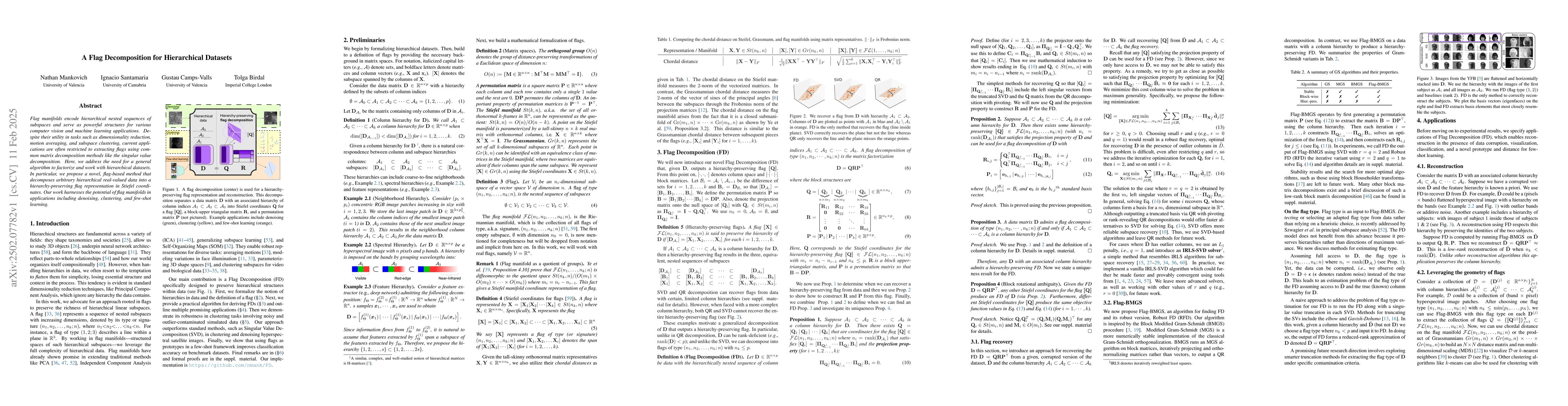
Flag manifolds encode hierarchical nested sequences of subspaces and serve as powerful structures for various computer vision and machine learning applications. Despite their utility in tasks such as ...
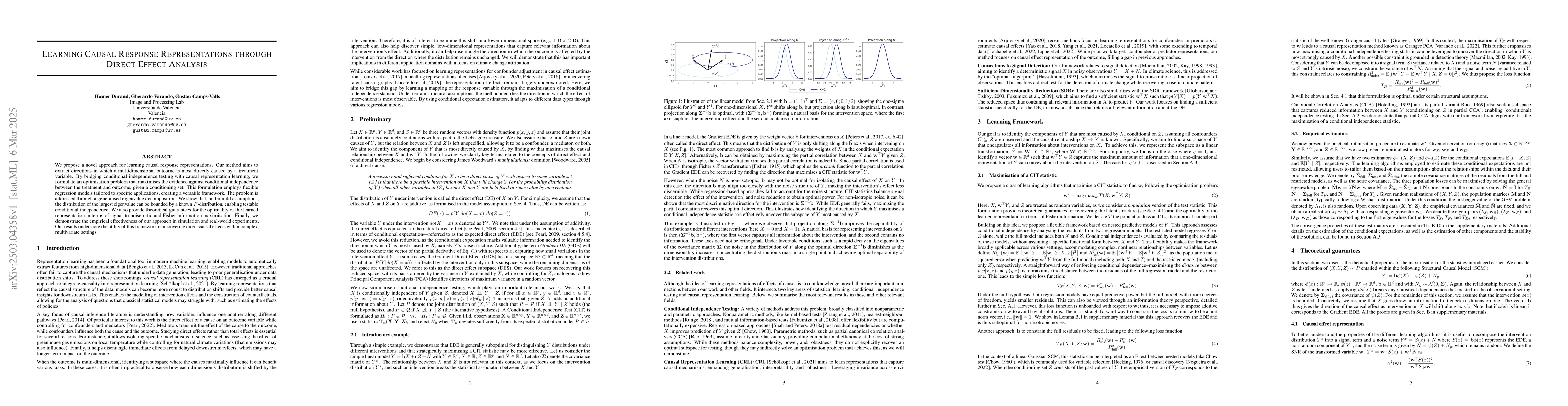
We propose a novel approach for learning causal response representations. Our method aims to extract directions in which a multidimensional outcome is most directly caused by a treatment variable. By ...
Recent advances in Computer Vision have introduced the concept of pretrained representation uncertainty, enabling zero-shot uncertainty estimation. This holds significant potential for Earth Observati...
Soil organic carbon (SOC) is a key indicator of soil health, fertility, and carbon sequestration, making it essential for sustainable land management and climate change mitigation. However, large-scal...
Label noise poses a significant challenge in Earth Observation (EO), often degrading the performance and reliability of supervised Machine Learning (ML) models. Yet, given the critical nature of sever...
Foundation Models (FMs) are large-scale, pre-trained AI systems that have revolutionized natural language processing and computer vision, and are now advancing geospatial analysis and Earth Observatio...
Wildfires are among the most severe natural hazards, posing a significant threat to both humans and natural ecosystems. The growing risk of wildfires increases the demand for forecasting models that a...
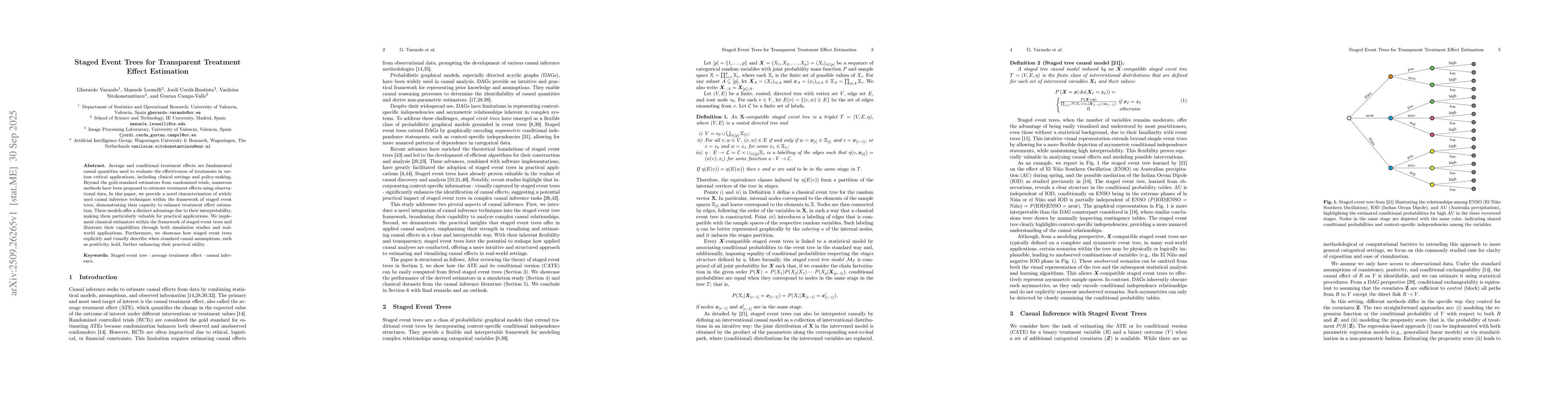
Average and conditional treatment effects are fundamental causal quantities used to evaluate the effectiveness of treatments in various critical applications, including clinical settings and policy-ma...
Earth observation involves collecting, analyzing, and processing an ever-growing mass of data. Automatically harvesting information is crucial for addressing significant societal, economic, and enviro...
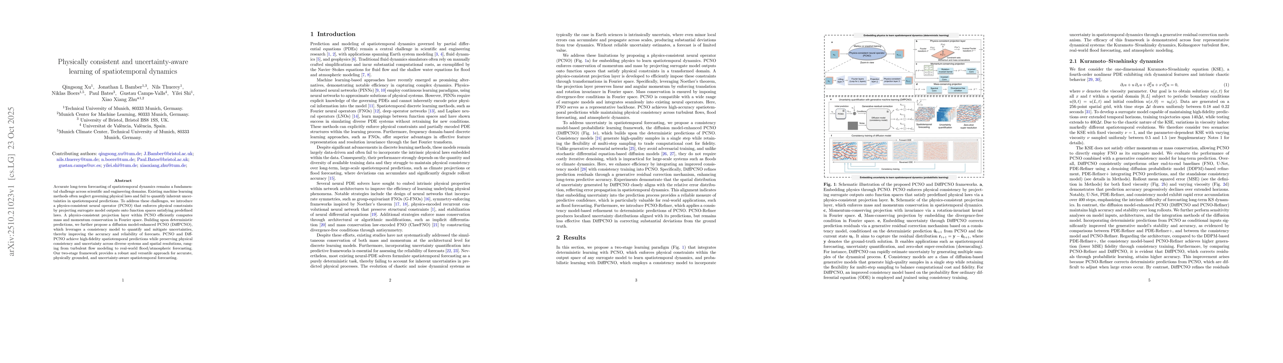
Accurate long-term forecasting of spatiotemporal dynamics remains a fundamental challenge across scientific and engineering domains. Existing machine learning methods often neglect governing physical ...
Forecasting wildfires weeks to months in advance is difficult, yet crucial for planning fuel treatments and allocating resources. While short-term predictions typically rely on local weather condition...
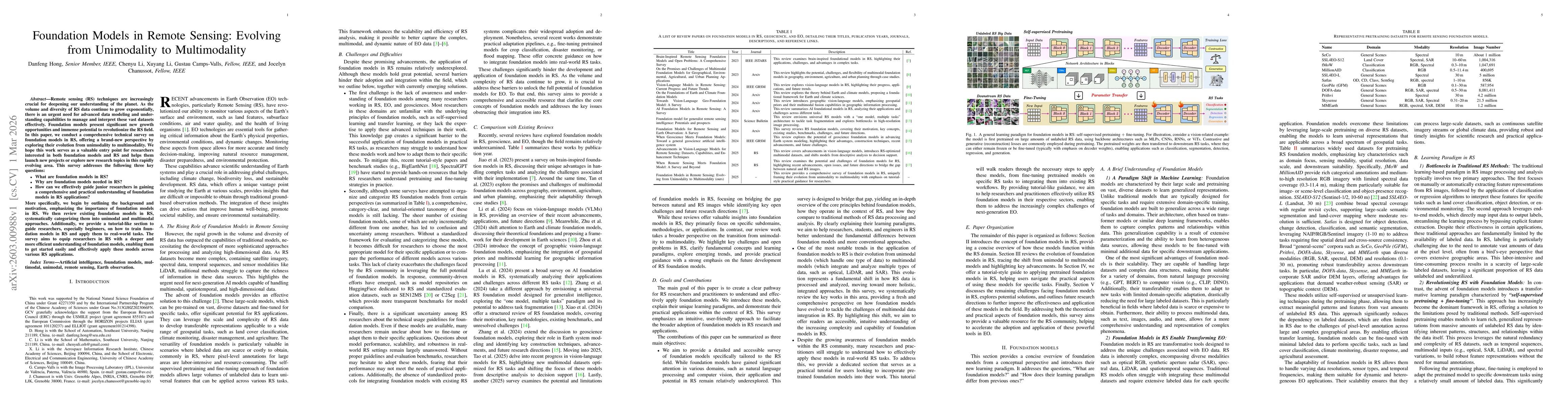
Remote sensing (RS) techniques are increasingly crucial for deepening our understanding of the planet. As the volume and diversity of RS data continue to grow exponentially, there is an urgent need fo...