Junchuan Yu

5 papers on arXiv

Academic Profile

Name: Junchuan Yu
Total Papers: 42

Statistics

arXiv Papers 5
Total Publications 42

Papers on arXiv

Thumbnail for TransLandSeg: A Transfer Learning Approach for Landslide Semantic
  Segmentation Based on Vision Foundation Model

TransLandSeg: A Transfer Learning Approach for Landslide Semantic Segmentation Based on Vision Foundation Model

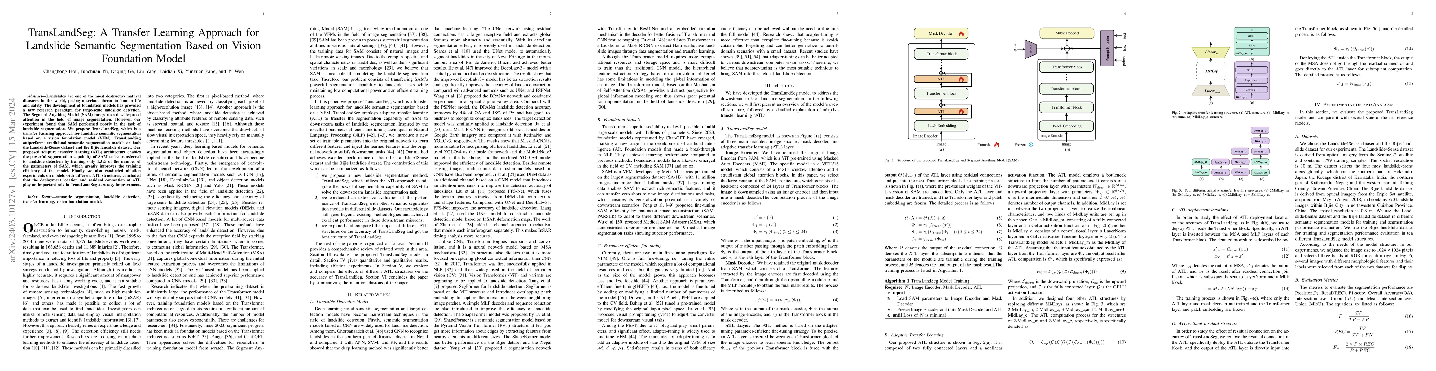
Landslides are one of the most destructive natural disasters in the world, posing a serious threat to human life and safety. The development of foundation models has provided a new research paradigm...

Thumbnail for Hyper-pixel-wise Contrastive Learning Augmented Segmentation Network for
  Old Landslide Detection through Fusing High-Resolution Remote Sensing Images
  and Digital Elevation Model Data

Hyper-pixel-wise Contrastive Learning Augmented Segmentation Network for Old Landslide Detection through Fusing High-Resolution Remote Sensing Images and Digital Elevation Model Data

As a natural disaster, landslide often brings tremendous losses to human lives, so it urgently demands reliable detection of landslide risks. When detecting old landslides that present important inf...

Thumbnail for An Iterative Classification and Semantic Segmentation Network for Old
  Landslide Detection Using High-Resolution Remote Sensing Images

An Iterative Classification and Semantic Segmentation Network for Old Landslide Detection Using High-Resolution Remote Sensing Images

Huge challenges exist for old landslide detection because their morphology features have been partially or strongly transformed over a long time and have little difference from their surrounding. Be...

Thumbnail for DDU-Net: Dual-Decoder-U-Net for Road Extraction Using High-Resolution
  Remote Sensing Images

DDU-Net: Dual-Decoder-U-Net for Road Extraction Using High-Resolution Remote Sensing Images

Extracting roads from high-resolution remote sensing images (HRSIs) is vital in a wide variety of applications, such as autonomous driving, path planning, and road navigation. Due to the long and th...

Thumbnail for MRIFE: A Mask-Recovering and Interactive-Feature-Enhancing Semantic
  Segmentation Network For Relic Landslide Detection

MRIFE: A Mask-Recovering and Interactive-Feature-Enhancing Semantic Segmentation Network For Relic Landslide Detection

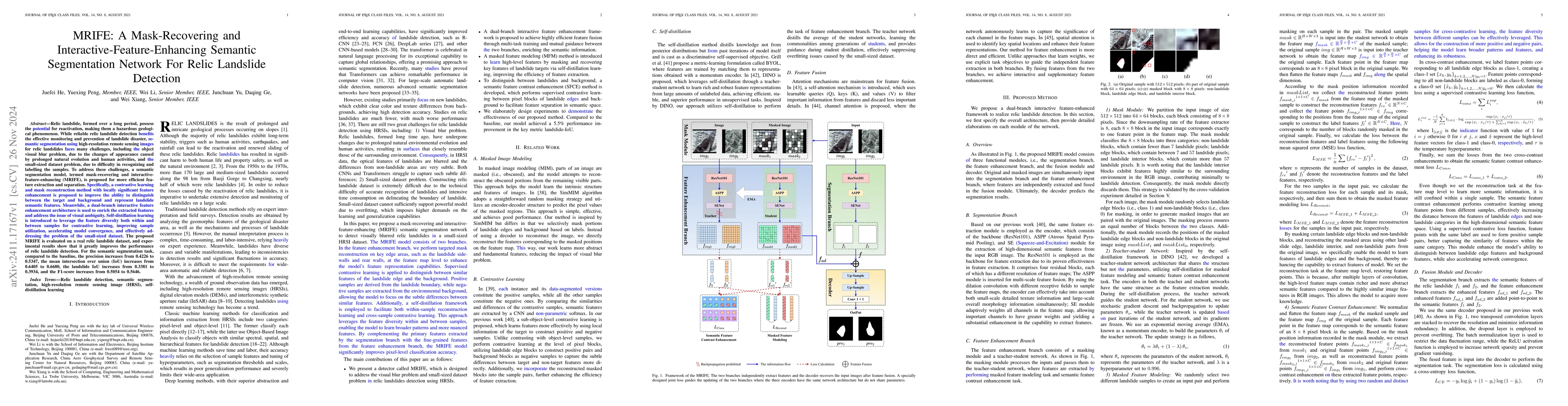
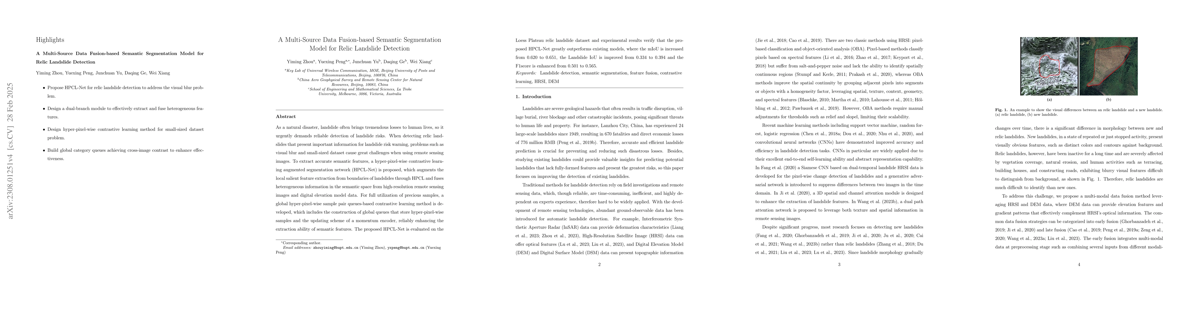
Relic landslide, formed over a long period, possess the potential for reactivation, making them a hazardous geological phenomenon. While reliable relic landslide detection benefits the effective monit...
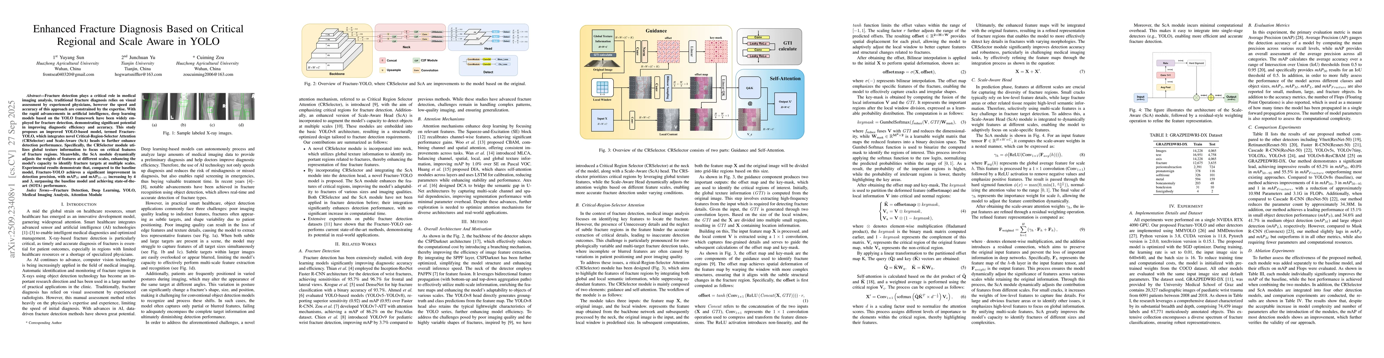
This website uses cookies to ensure you get the best experience. Learn more