This paper proposes a hyper-pixel-wise contrastive learning augmented segmentation network (HPCL-Net) for detecting old landslides using high-resolution remote sensing images and digital elevation model data. The HPCL-Net significantly improves the extraction of semantic features and outperforms existing models, enhancing mIoU, Landslide IoU, and F1 score.
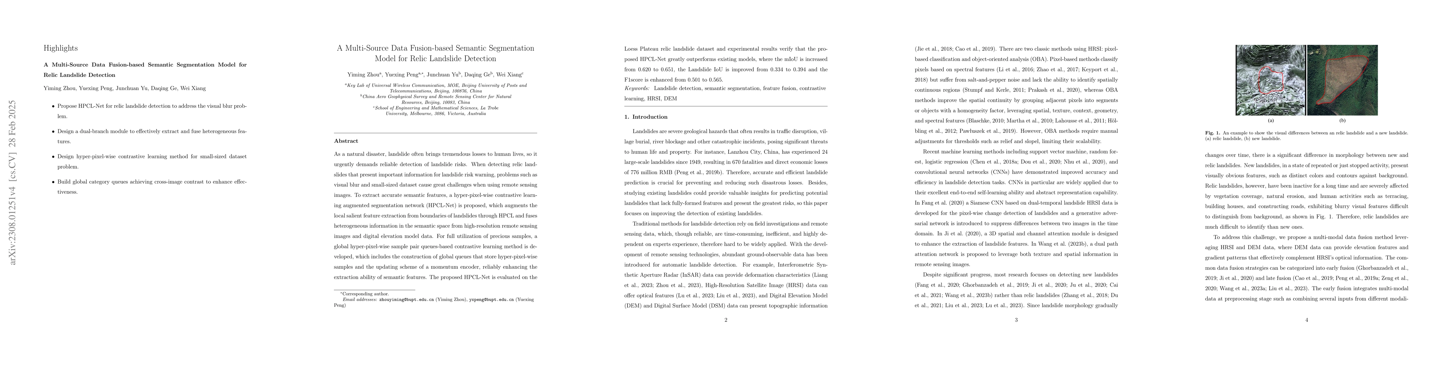
As a natural disaster, landslide often brings tremendous losses to human lives, so it urgently demands reliable detection of landslide risks. When detecting old landslides that present important information for landslide risk warning, problems such as visual blur and small-sized dataset cause great challenges when using remote sensing data. To extract accurate semantic features, a hyper-pixel-wise contrastive learning augmented segmentation network (HPCL-Net) is proposed, which augments the local salient feature extraction from boundaries of landslides through HPCL-Net and fuses heterogeneous infromation in the semantic space from high-resolution remote sensing images and digital elevation model data. For full utilization of precious samples, a global hyper-pixel-wise sample pair queues-based contrastive learning method is developed, which includes the construction of global queues that store hyper-pixel-wise samples and the updating scheme of a momentum encoder, reliably enhancing the extraction ability of semantic features. The proposed HPCL-Net is evaluated on the Loess Plateau old landslide dataset and experimental results verify that the proposed HPCL-Net greatly outperforms existing models, where the mIoU is increased from 0.620 to 0.651, the Landslide IoU is improved from 0.334 to 0.394 and the F1score is enhanced from 0.501 to 0.565.
Get AI-generated insights about this paper's methodology, results, and significance.
Current paper (gray), citations (green), references (blue)
No similar papers found for this research.
No citations found for this paper.
Title | Authors | Year | Actions |
---|---|---|---|
A novel landslide identification method for multi-scale and complex background region based on multi-model fusion: YOLO + U-Net
|
Honghui Wang, Jie Liu, Shangkun Zeng, Kaiwen Xiao, Dongying Yang, Guangle Yao, Ronghao Yang
|
2023
|
View Paper |
Time-Series InSAR with Deep-Learning-Based Topography-Dependent Atmospheric Delay Correction for Potential Landslide Detection
|
Hao Zhou, Keren Dai, Xiaochuan Tang, Jianming Xiang, Rongpeng Li, Mingtang Wu, Yangrui Peng, Zhenhong Li
|
2023
|
View Paper |
Automatic Identification for the Boundaries of InSAR Anomalous Deformation Areas Based on Semantic Segmentation Model
|
Yiwen Liang, Yi Zhang, Yuanxi Li, Jiaqi Xiong
|
2023
|
View Paper |
Dual Path Attention Network (DPANet) for Intelligent Identification of Wenchuan Landslides
|
Xiao Wang, Di Wang, Tiegang Sun, Jianhui Dong, Luting Xu, Wei-le Li, Shaoda Li, Peilian Ran, Jinxi Ao, Yulan Zou, Jing Wang, Xinnian Zeng
|
2023
|
View Paper |
An Iterative Classification and Semantic Segmentation Network for Old Landslide Detection Using High-Resolution Remote Sensing Images
|
Ziling Lu, Yuexing Peng, W. Li, Junchuan Yu, D. Ge, Wei Xiang
|
2023
|
View Paper |
Coordinate Attention for Efficient Mobile Network Design
|
Qibin Hou, Daquan Zhou, Jiashi Feng
|
2021
|
View Paper |
Exploring Cross-Image Pixel Contrast for Semantic Segmentation
|
Wenguan Wang, Tianfei Zhou, F. Yu, Jifeng Dai, E. Konukoglu, L. Gool
|
2021
|
View Paper |
Automatic Object Detection of Loess Landslide Based on Deep Learning
|
Ju Yuanzhen, Xu Qiang, Jin Shichao, L. Weile, Dong Xiujun, Guo Qinghua
|
2020
|
View Paper |
Contrastive Learning with Hard Negative Samples
|
Joshua Robinson, Ching-Yao Chuang, S. Sra, S. Jegelka
|
2020
|
View Paper |
Landslide Detection and Susceptibility Modeling on Cameron Highlands (Malaysia): A Comparison between Random Forest, Logistic Regression and Logistic Model Tree Algorithms
|
Viet-Ha Nhu, A. Mohammadi, H. Shahabi, B. Ahmad, N. Al‐Ansari, A. Shirzadi, M. Geertsema, Victoria R. Kress, S. Karimzadeh, Khalil Valizadeh Kamran, Wei Chen, Hoang Nguyen
|
2020
|
View Paper |
Supervised Contrastive Learning
|
Prannay Khosla, Piotr Teterwak, Chen Wang, Aaron Sarna, Yonglong Tian, Phillip Isola, Aaron Maschinot, Ce Liu, Dilip Krishnan
|
2020
|
View Paper |
GAN-Based Siamese Framework for Landslide Inventory Mapping Using Bi-Temporal Optical Remote Sensing Images
|
Bo Fang, Gang Chen, Li Pan, Rong Kou, Lizhe Wang
|
2020
|
View Paper |
A Simple Framework for Contrastive Learning of Visual Representations
|
Ting Chen, Simon Kornblith, Mohammad Norouzi, Geoffrey E. Hinton
|
2020
|
View Paper |
Landslide detection from an open satellite imagery and digital elevation model dataset using attention boosted convolutional neural networks
|
Shunping Ji, Dawen Yu, Chaoyong Shen, Wei-le Li, Qiang Xu
|
2020
|
View Paper |
Mapping Landslides on EO Data: Performance of Deep Learning Models vs. Traditional Machine Learning Models
|
N. Prakash, A. Manconi, S. Loew
|
2020
|
View Paper |
Momentum Contrast for Unsupervised Visual Representation Learning
|
Kaiming He, Haoqi Fan, Yuxin Wu, Saining Xie, Ross B. Girshick
|
2019
|
View Paper |
Improved landslide assessment using support vector machine with bagging, boosting, and stacking ensemble machine learning framework in a mountainous watershed, Japan
|
J. Dou, Ali. P. Yunus, D. Bui, Abdelaziz Merghadi, M. Sahana, Zhongfan Zhu, Chi-Wen Chen, Zheng Han, B. Pham
|
2019
|
View Paper |
Multi-Aspect Analysis of Object-Oriented Landslide Detection Based on an Extended Set of LiDAR-Derived Terrain Features
|
Kamila Pawluszek, Sylwia Marczak, A. Borkowski, P. Tarolli
|
2019
|
View Paper |
End-to-End DSM Fusion Networks for Semantic Segmentation in High-Resolution Aerial Images
|
Zhiying Cao, Kun Fu, Xiao-De Lu, W. Diao, Hao Sun, M. Yan, Hongfeng Yu, Xian Sun
|
2019
|
View Paper |
Densely Based Multi-Scale and Multi-Modal Fully Convolutional Networks for High-Resolution Remote-Sensing Image Semantic Segmentation
|
Cheng Peng, Yangyang Li, L. Jiao, Yanqiao Chen, Ronghua Shang
|
2019
|
View Paper |
Sentinel-1 SAR Amplitude Imagery for Rapid Landslide Detection
|
A. Mondini, M. Santangelo, Margherita Rocchetti, Enrica Rossetto, A. Manconi, O. Monserrat
|
2019
|
View Paper |
Evaluation of Different Machine Learning Methods and Deep-Learning Convolutional Neural Networks for Landslide Detection
|
O. Ghorbanzadeh, T. Blaschke, Khalil Gholamnia, S. Meena, D. Tiede, J. Aryal
|
2019
|
View Paper |
Unsupervised Feature Learning via Non-parametric Instance Discrimination
|
Zhirong Wu, Yuanjun Xiong, Stella X. Yu, Dahua Lin
|
2018
|
View Paper |
A practical trial of landslide detection from single-temporal Landsat8 images using contour-based proposals and random forest: a case study of national Nepal
|
Fang Chen, Bo Yu, Bin Li
|
2018
|
View Paper |
Encoder-Decoder with Atrous Separable Convolution for Semantic Image Segmentation
|
Liang-Chieh Chen, Yukun Zhu, G. Papandreou, Florian Schroff, Hartwig Adam
|
2018
|
View Paper |
A comparative analysis of pixel- and object-based detection of landslides from very high-resolution images
|
Ren N. Keyport, T. Oommen, T. Martha, K. S. Sajinkumar, J. Gierke
|
2018
|
View Paper |
Squeeze-and-Excitation Networks
|
Jie Hu, Li Shen, Samuel Albanie, Gang Sun, E. Wu
|
2017
|
View Paper |
Rethinking Atrous Convolution for Semantic Image Segmentation
|
Liang-Chieh Chen, G. Papandreou, Florian Schroff, Hartwig Adam
|
2017
|
View Paper |
Postearthquake Landslides Mapping From Landsat-8 Data for the 2015 Nepal Earthquake Using a Pixel-Based Change Detection Method
|
Wei Zhao, Ainong Li, Xi Nan, Zhengjia Zhang, G. Lei
|
2017
|
View Paper |
Landslide mapping from aerial photographs using change detection-based Markov random field
|
Zhongbin Li, W. Shi, P. Lu, Lin Yan, Qunming Wang, Z. Miao
|
2016
|
View Paper |
Grad-CAM: Visual Explanations from Deep Networks via Gradient-Based Localization
|
Ramprasaath R. Selvaraju, Abhishek Das, Ramakrishna Vedantam, Michael Cogswell, Devi Parikh, Dhruv Batra
|
2016
|
View Paper |
DeepLab: Semantic Image Segmentation with Deep Convolutional Nets, Atrous Convolution, and Fully Connected CRFs
|
Liang-Chieh Chen, G. Papandreou, Iasonas Kokkinos, K. Murphy, A. Yuille
|
2016
|
View Paper |
High resolution images
|
2016
|
View Paper | |
A Semi-Automated Object-Based Approach for Landslide Detection Validated by Persistent Scatterer Interferometry Measures and Landslide Inventories
|
D. Hölbling, P. Füreder, F. Antolini, F. Cigna, N. Casagli, S. Lang
|
2012
|
View Paper |
Object-oriented mapping of landslides using Random Forests
|
A. Stumpf, N. Kerle
|
2011
|
View Paper |
Landslide mapping with multi-scale object-based image analysis – a case study in the Baichi watershed, Taiwan
|
T. Lahousse, Kang-Tsung Chang, Y. Lin
|
2011
|
View Paper |
Characterising spectral, spatial and morphometric properties of landslides for semi-automatic detection using object-oriented methods
|
T. Martha, N. Kerle, V. Jetten, C. V. van Westen, K. V. Kumar
|
2010
|
View Paper |
Feature-Fusion Segmentation Network for Landslide Detection Using High-Resolution Remote Sensing Images and Digital Elevation Model Data
|
Xinran Liu, Yuexing Peng, Zili Lu, Wei Li, Junchuan Yu, D. Ge, Wei Xiang
|
2023
|
View Paper |
A Novel Region-Based Image Registration Method for Multisource Remote Sensing Images Via CNN
|
Liang Zeng, Yanlei Du, Huiping Lin, J. Wang, Junjun Yin, Jian Yang
|
2021
|
View Paper |
Landslide Detection Using Densely Connected Convolutional Networks and Environmental Conditions
|
Haojie Cai, Tao Chen, R. Niu, A. Plaza
|
2021
|
View Paper |
Landslide susceptibility prediction based on image semantic segmentation
|
B. Du, Zirong Zhao, Xiao Hu, Guanghui Wu, Liangzhe Han, Leilei Sun, Qiang Gao
|
2021
|
View Paper |
Landslide disasters in the Loess Plateau
|
2019
|
||
Progress and prospect of research on reactivation of ancient landslides
|
2018
|
||
Landslide detection based on dem matching
|
2018
|
||
The impact and control of atmospheric precipitation on the formation of loess landslides——an example of longxi loess plateau in gansu province
|
2013
|
||
Study on Temporal and Spatial Changes of the Potential Evapotranspiration and Its Impact Factors in Loess Plateau of Gansu Province
|
Zhuo Malancao, Liu Pu-xing, Zhang Yaning, W. Hongyan, Cao Liguo
|
2012
|
View Paper |
Object based image analysis for remote sensing
|
T. Blaschke
|
2010
|
View Paper |
Research progress on ecological restoration of landslide damaged land in typical hilly and gully areas of the loess plateau
|
|||
Geotech
|
Showing first page preview. Click "Open Full PDF" to view the complete paper.
Your comment contains inappropriate language and has been rejected.
Are you sure you want to remove this tag? This action cannot be undone.
Someone just favorited a paper!
Comments (0)