Junjue Wang

22 papers on arXiv

Academic Profile

Name: Junjue Wang
Total Papers: 51

Statistics

arXiv Papers 22
Total Publications 51

Papers on arXiv

Thumbnail for EarthVQA: Towards Queryable Earth via Relational Reasoning-Based Remote
  Sensing Visual Question Answering

EarthVQA: Towards Queryable Earth via Relational Reasoning-Based Remote Sensing Visual Question Answering

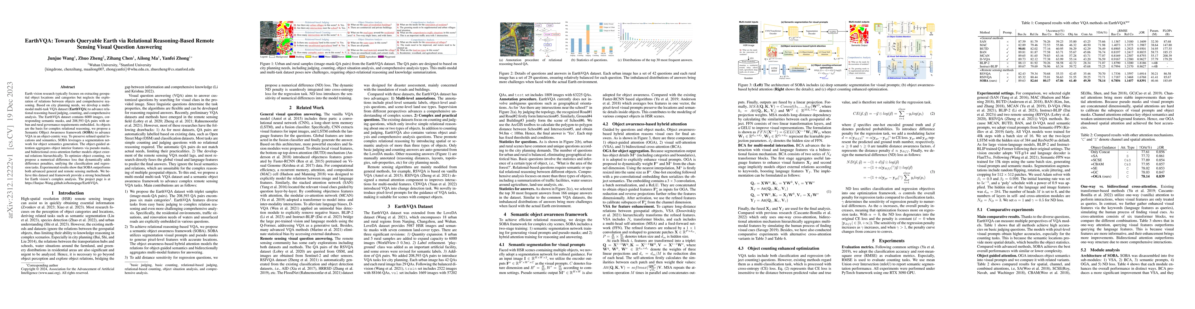
Earth vision research typically focuses on extracting geospatial object locations and categories but neglects the exploration of relations between objects and comprehensive reasoning. Based on city ...

Thumbnail for Seeing Beyond the Patch: Scale-Adaptive Semantic Segmentation of
  High-resolution Remote Sensing Imagery based on Reinforcement Learning

Seeing Beyond the Patch: Scale-Adaptive Semantic Segmentation of High-resolution Remote Sensing Imagery based on Reinforcement Learning

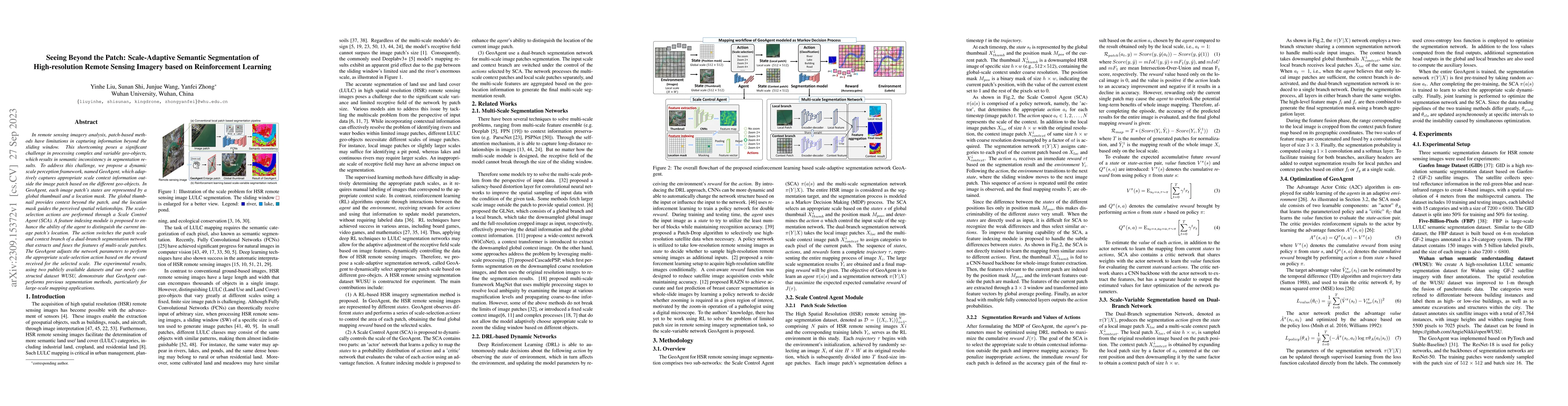
In remote sensing imagery analysis, patch-based methods have limitations in capturing information beyond the sliding window. This shortcoming poses a significant challenge in processing complex and ...

Thumbnail for The Outcome of the 2022 Landslide4Sense Competition: Advanced Landslide
  Detection from Multi-Source Satellite Imagery

The Outcome of the 2022 Landslide4Sense Competition: Advanced Landslide Detection from Multi-Source Satellite Imagery

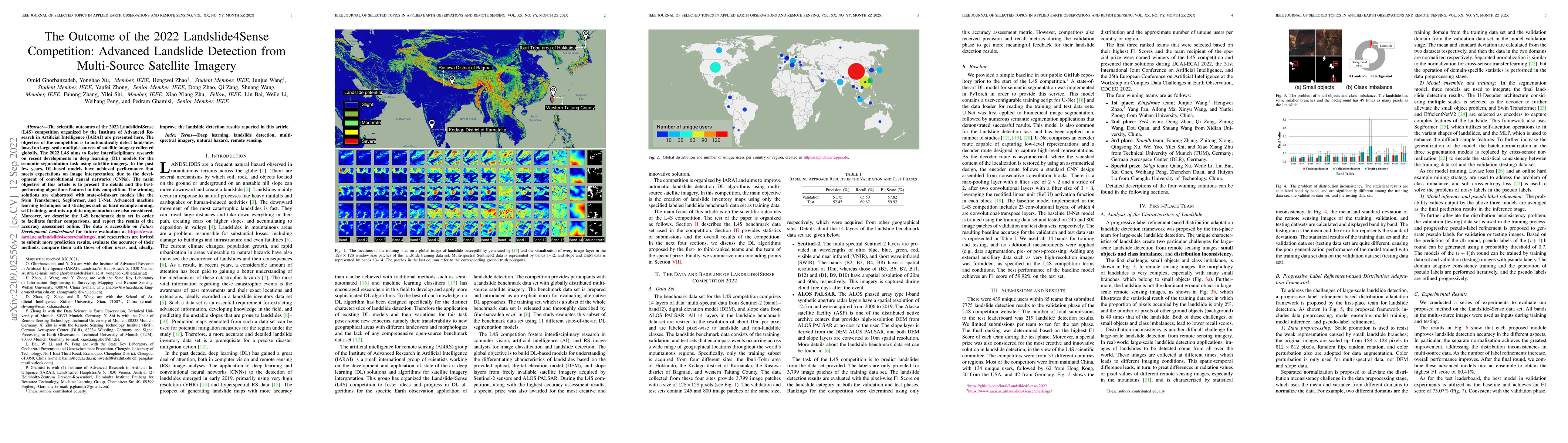
The scientific outcomes of the 2022 Landslide4Sense (L4S) competition organized by the Institute of Advanced Research in Artificial Intelligence (IARAI) are presented here. The objective of the comp...

Thumbnail for AutoLC: Search Lightweight and Top-Performing Architecture for Remote
  Sensing Image Land-Cover Classification

AutoLC: Search Lightweight and Top-Performing Architecture for Remote Sensing Image Land-Cover Classification

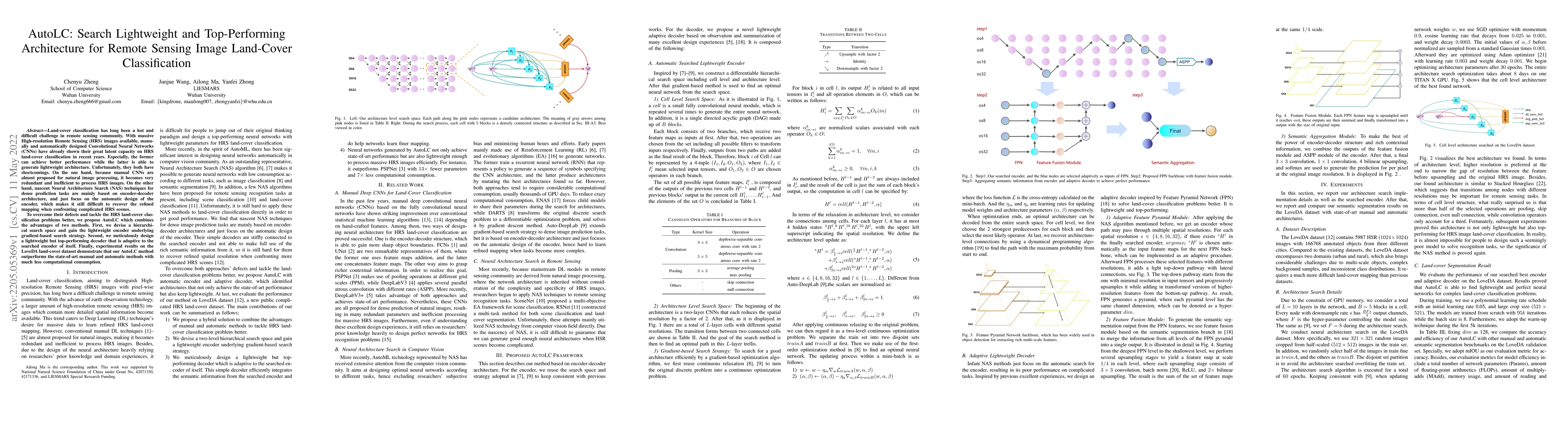
Land-cover classification has long been a hot and difficult challenge in remote sensing community. With massive High-resolution Remote Sensing (HRS) images available, manually and automatically desi...

Thumbnail for LoveDA: A Remote Sensing Land-Cover Dataset for Domain Adaptive Semantic
  Segmentation

LoveDA: A Remote Sensing Land-Cover Dataset for Domain Adaptive Semantic Segmentation

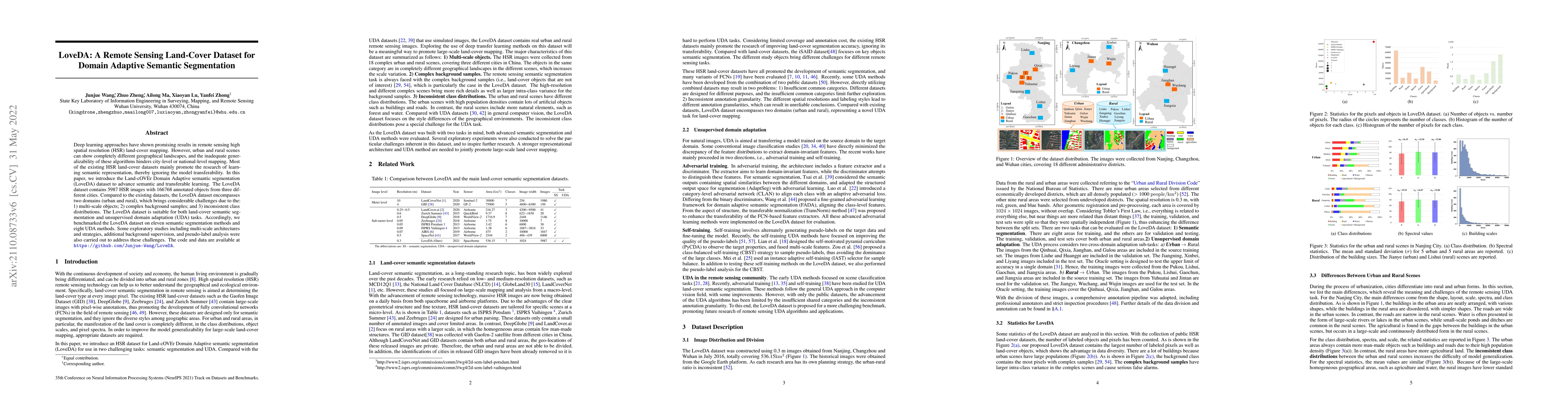
Deep learning approaches have shown promising results in remote sensing high spatial resolution (HSR) land-cover mapping. However, urban and rural scenes can show completely different geographical l...

Thumbnail for Ajalon: Simplifying the Authoring of Wearable Cognitive Assistants

Ajalon: Simplifying the Authoring of Wearable Cognitive Assistants

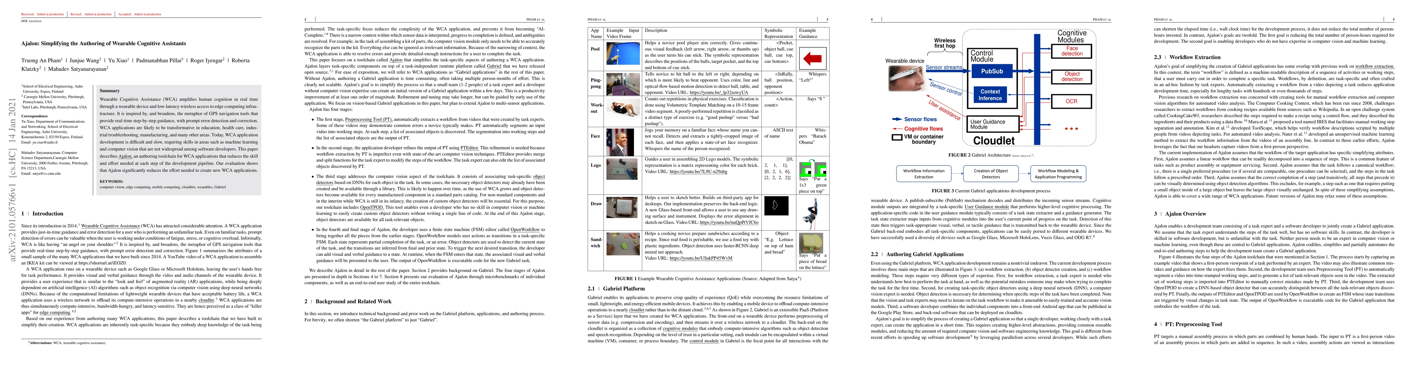
Wearable Cognitive Assistance (WCA) amplifies human cognition in real time through a wearable device and low-latency wireless access to edge computing infrastructure. It is inspired by, and broadens...

Thumbnail for Foreground-Aware Relation Network for Geospatial Object Segmentation in
  High Spatial Resolution Remote Sensing Imagery

Foreground-Aware Relation Network for Geospatial Object Segmentation in High Spatial Resolution Remote Sensing Imagery

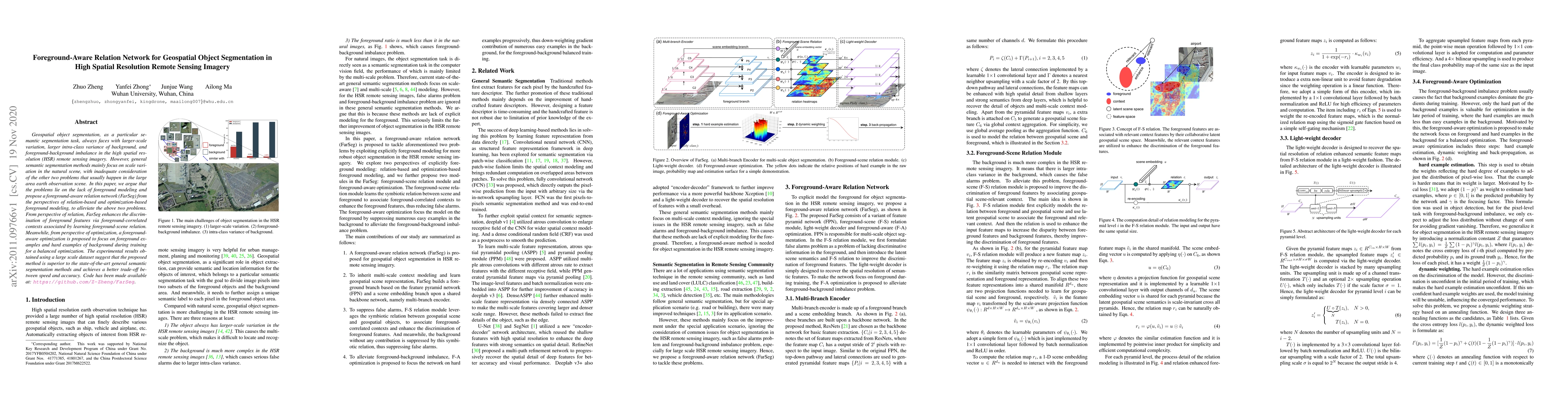
Geospatial object segmentation, as a particular semantic segmentation task, always faces with larger-scale variation, larger intra-class variance of background, and foreground-background imbalance i...

Thumbnail for Foundation Models for Remote Sensing and Earth Observation: A Survey

Foundation Models for Remote Sensing and Earth Observation: A Survey

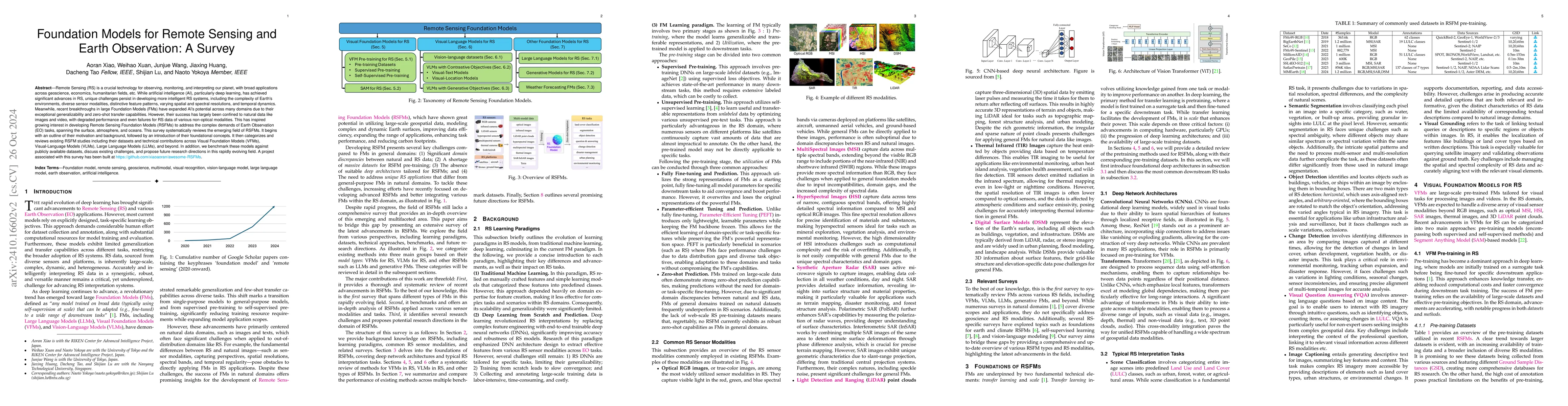
Remote Sensing (RS) is a crucial technology for observing, monitoring, and interpreting our planet, with broad applications across geoscience, economics, humanitarian fields, etc. While artificial int...

Thumbnail for BRIGHT: A globally distributed multimodal building damage assessment
  dataset with very-high-resolution for all-weather disaster response

BRIGHT: A globally distributed multimodal building damage assessment dataset with very-high-resolution for all-weather disaster response

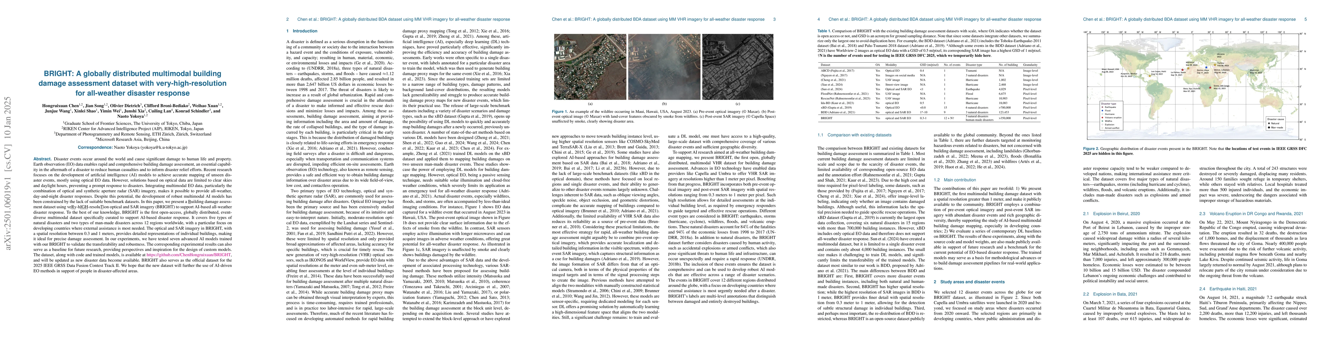
Disaster events occur around the world and cause significant damage to human life and property. Earth observation (EO) data enables rapid and comprehensive building damage assessment (BDA), an essenti...

Thumbnail for MMLU-ProX: A Multilingual Benchmark for Advanced Large Language Model
  Evaluation

MMLU-ProX: A Multilingual Benchmark for Advanced Large Language Model Evaluation

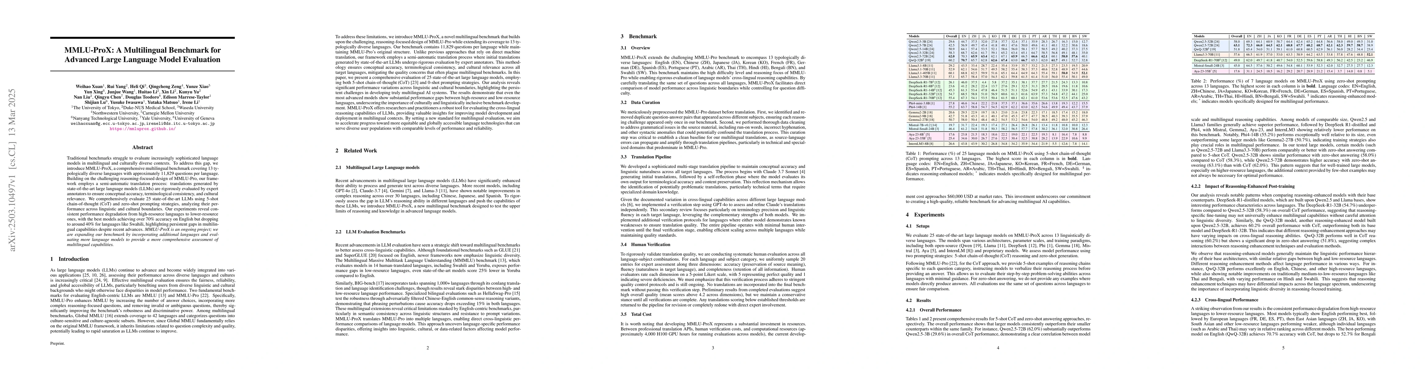
Traditional benchmarks struggle to evaluate increasingly sophisticated language models in multilingual and culturally diverse contexts. To address this gap, we introduce MMLU-ProX, a comprehensive mul...

Thumbnail for DisasterM3: A Remote Sensing Vision-Language Dataset for Disaster Damage
  Assessment and Response

DisasterM3: A Remote Sensing Vision-Language Dataset for Disaster Damage Assessment and Response

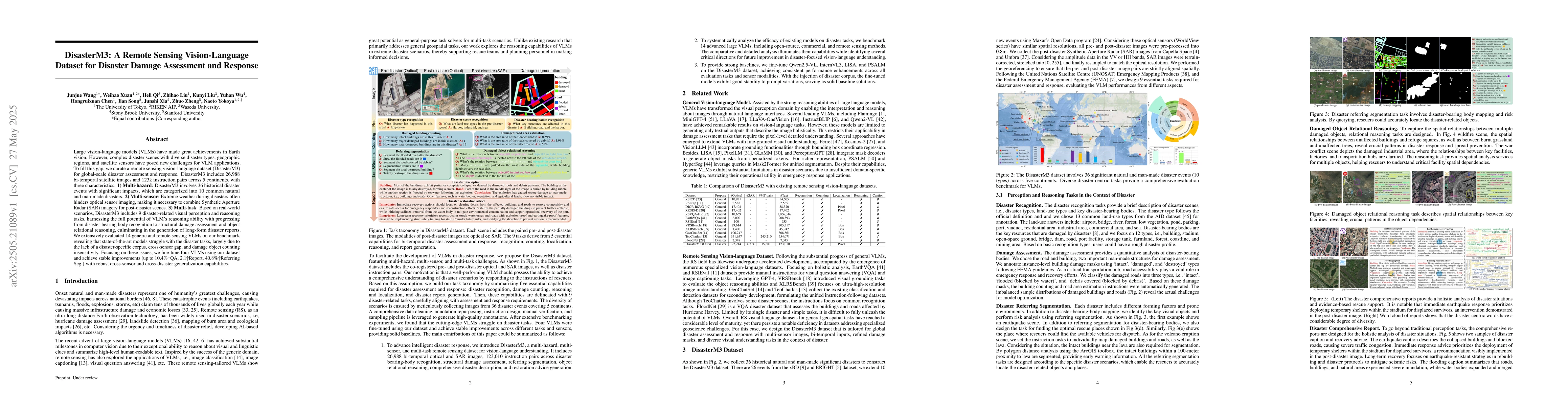
Large vision-language models (VLMs) have made great achievements in Earth vision. However, complex disaster scenes with diverse disaster types, geographic regions, and satellite sensors have posed new...

Thumbnail for DynamicVL: Benchmarking Multimodal Large Language Models for Dynamic
  City Understanding

DynamicVL: Benchmarking Multimodal Large Language Models for Dynamic City Understanding

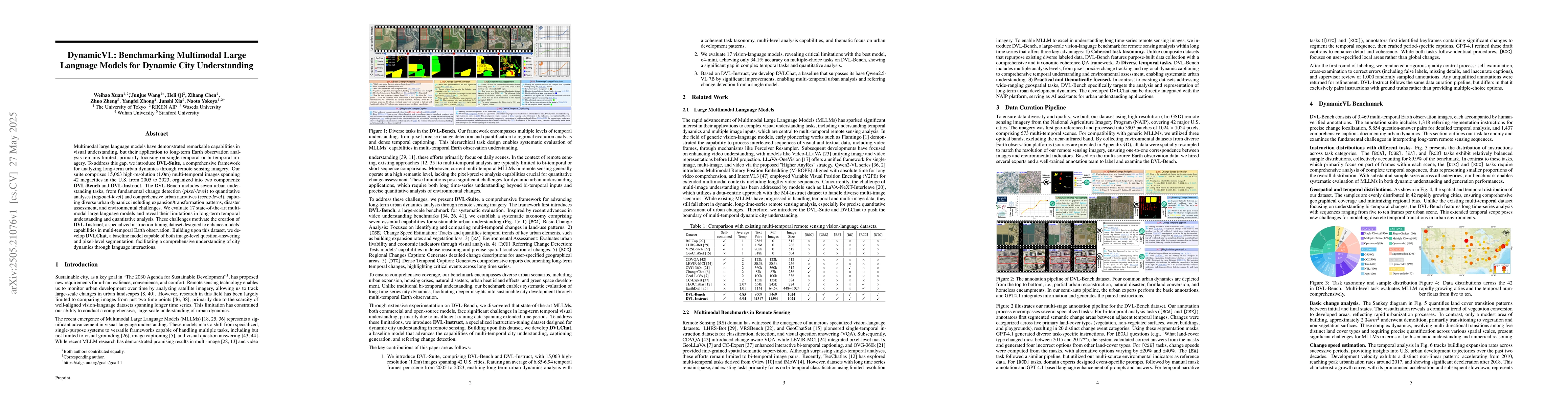
Multimodal large language models have demonstrated remarkable capabilities in visual understanding, but their application to long-term Earth observation analysis remains limited, primarily focusing on...

Thumbnail for Seeing is Believing, but How Much? A Comprehensive Analysis of
  Verbalized Calibration in Vision-Language Models

Seeing is Believing, but How Much? A Comprehensive Analysis of Verbalized Calibration in Vision-Language Models

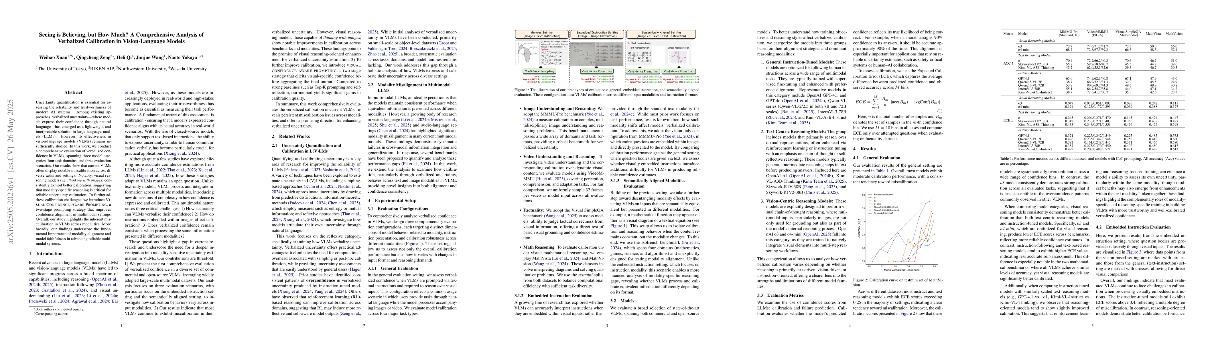
Uncertainty quantification is essential for assessing the reliability and trustworthiness of modern AI systems. Among existing approaches, verbalized uncertainty, where models express their confidence...

Thumbnail for Noisy-Pair Robust Representation Alignment for Positive-Unlabeled
  Learning

Noisy-Pair Robust Representation Alignment for Positive-Unlabeled Learning

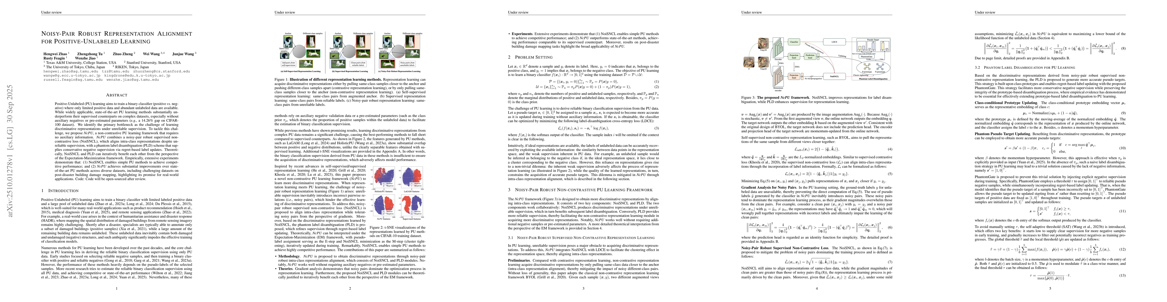
Positive-Unlabeled (PU) learning aims to train a binary classifier (positive vs. negative) where only limited positive data and abundant unlabeled data are available. While widely applicable, state-of...

Thumbnail for Geo3DVQA: Evaluating Vision-Language Models for 3D Geospatial Reasoning from Aerial Imagery

Geo3DVQA: Evaluating Vision-Language Models for 3D Geospatial Reasoning from Aerial Imagery

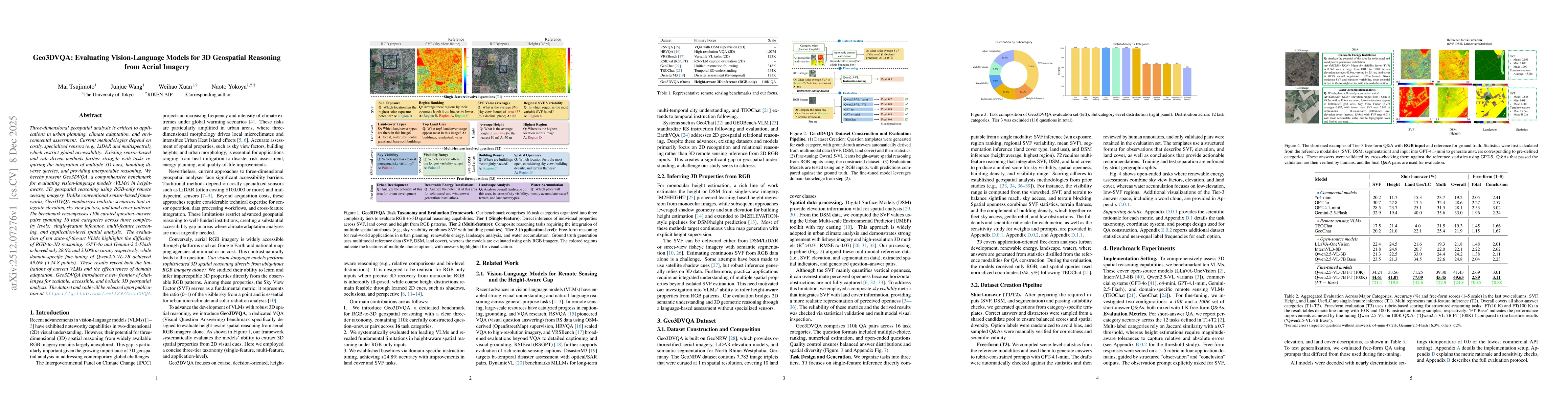
Three-dimensional geospatial analysis is critical to applications in urban planning, climate adaptation, and environmental assessment. Current methodologies depend on costly, specialized sensors (e.g....

Thumbnail for Toward Global Large Language Models in Medicine

Toward Global Large Language Models in Medicine

Despite continuous advances in medical technology, the global distribution of health care resources remains uneven. The development of large language models (LLMs) has transformed the landscape of med...

Thumbnail for EarthVL: A Progressive Earth Vision-Language Understanding and Generation Framework

EarthVL: A Progressive Earth Vision-Language Understanding and Generation Framework

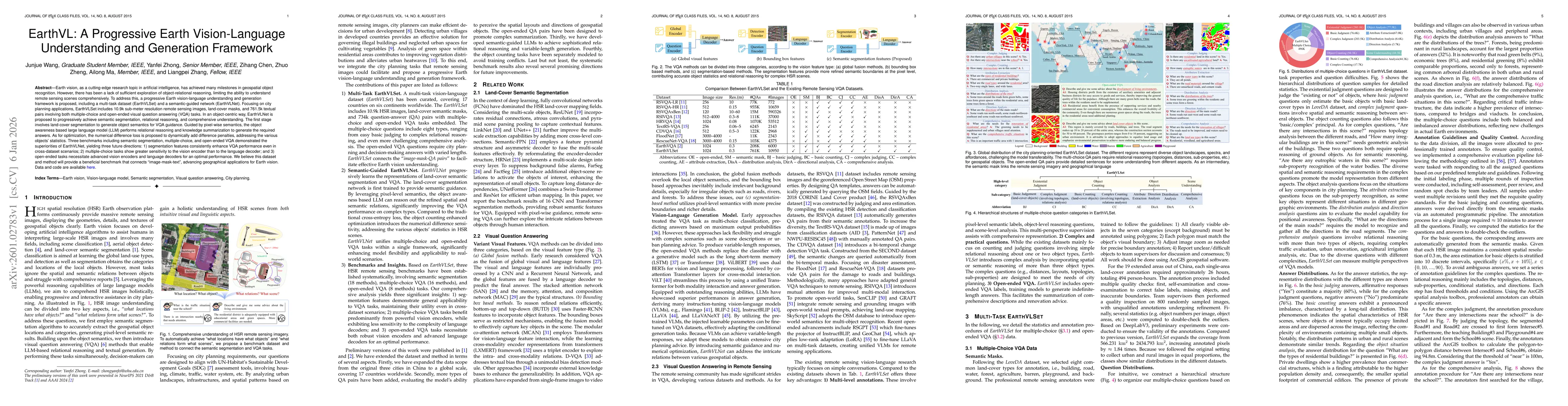
Earth vision has achieved milestones in geospatial object recognition but lacks exploration in object-relational reasoning, limiting comprehensive scene understanding. To address this, a progressive E...

Thumbnail for The Confidence Dichotomy: Analyzing and Mitigating Miscalibration in Tool-Use Agents

The Confidence Dichotomy: Analyzing and Mitigating Miscalibration in Tool-Use Agents

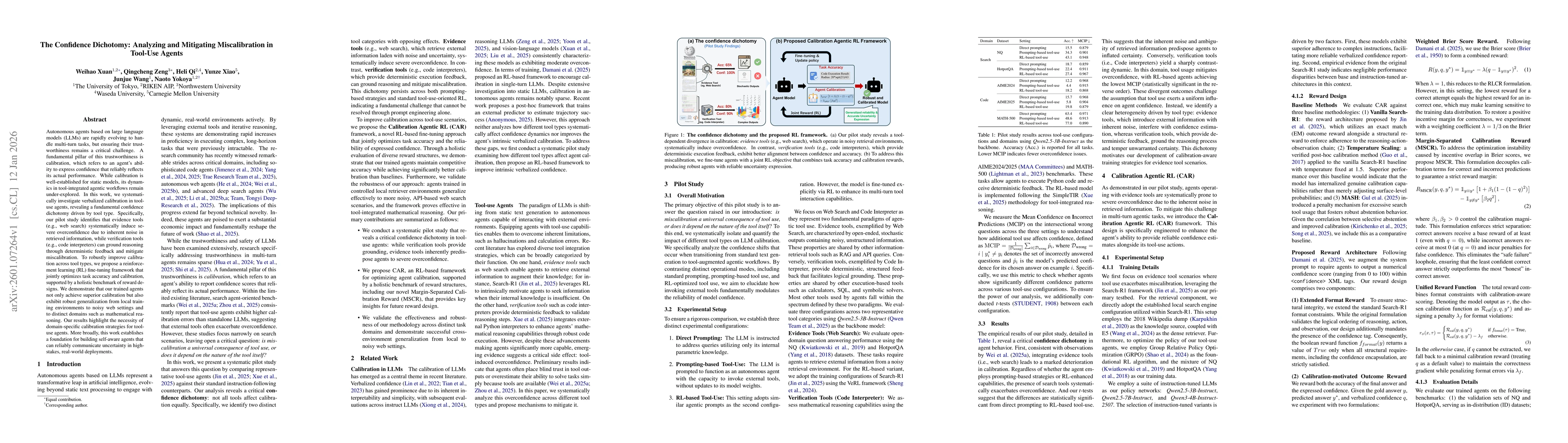
Autonomous agents based on large language models (LLMs) are rapidly evolving to handle multi-turn tasks, but ensuring their trustworthiness remains a critical challenge. A fundamental pillar of this t...

Thumbnail for Experience-Driven Multi-Agent Systems Are Training-free Context-aware Earth Observers

Experience-Driven Multi-Agent Systems Are Training-free Context-aware Earth Observers

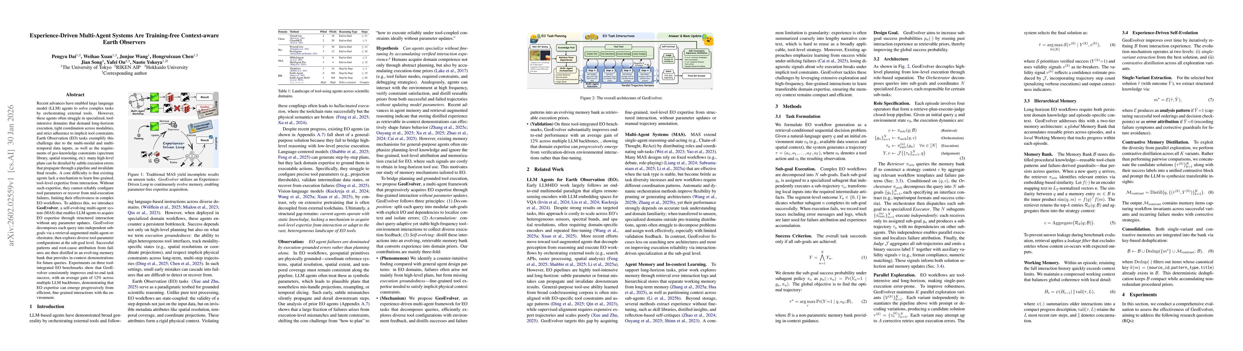
Recent advances have enabled large language model (LLM) agents to solve complex tasks by orchestrating external tools. However, these agents often struggle in specialized, tool-intensive domains that ...

Thumbnail for Direction-aware 3D Large Multimodal Models

Direction-aware 3D Large Multimodal Models

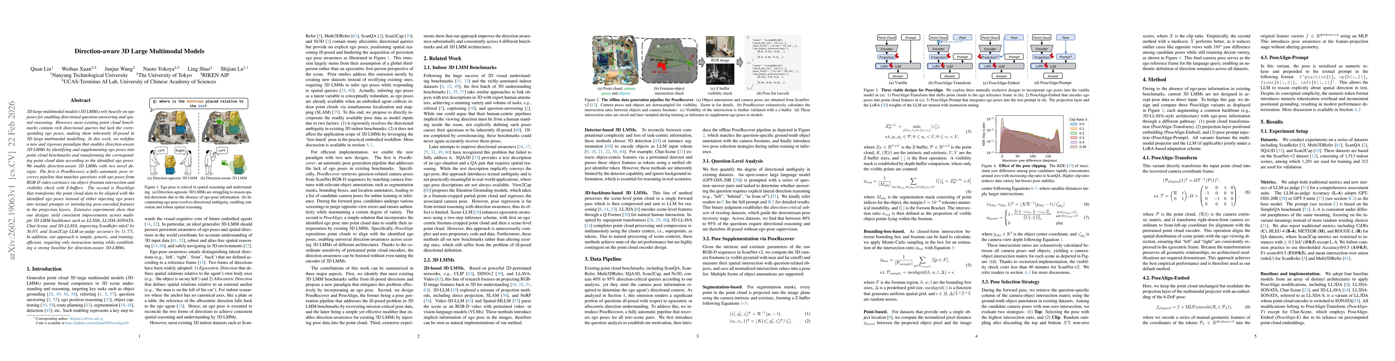
3D large multimodal models (3D LMMs) rely heavily on ego poses for enabling directional question-answering and spatial reasoning. However, most existing point cloud benchmarks contain rich directional...

Thumbnail for OpenEarth-Agent: From Tool Calling to Tool Creation for Open-Environment Earth Observation

OpenEarth-Agent: From Tool Calling to Tool Creation for Open-Environment Earth Observation

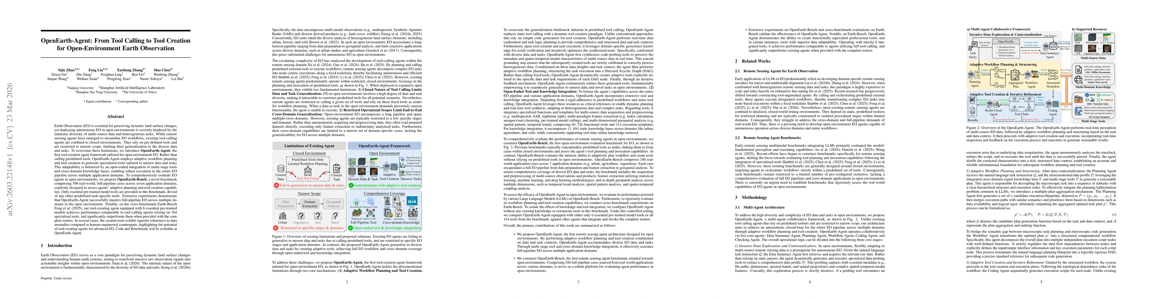
Earth Observation (EO) is essential for perceiving dynamic land surface changes, yet deploying autonomous EO in open environments is hindered by the immense diversity of multi-source data and heteroge...

Thumbnail for Can LLM Agents Respond to Disasters? Benchmarking Heterogeneous Geospatial Reasoning in Emergency Operations

Can LLM Agents Respond to Disasters? Benchmarking Heterogeneous Geospatial Reasoning in Emergency Operations

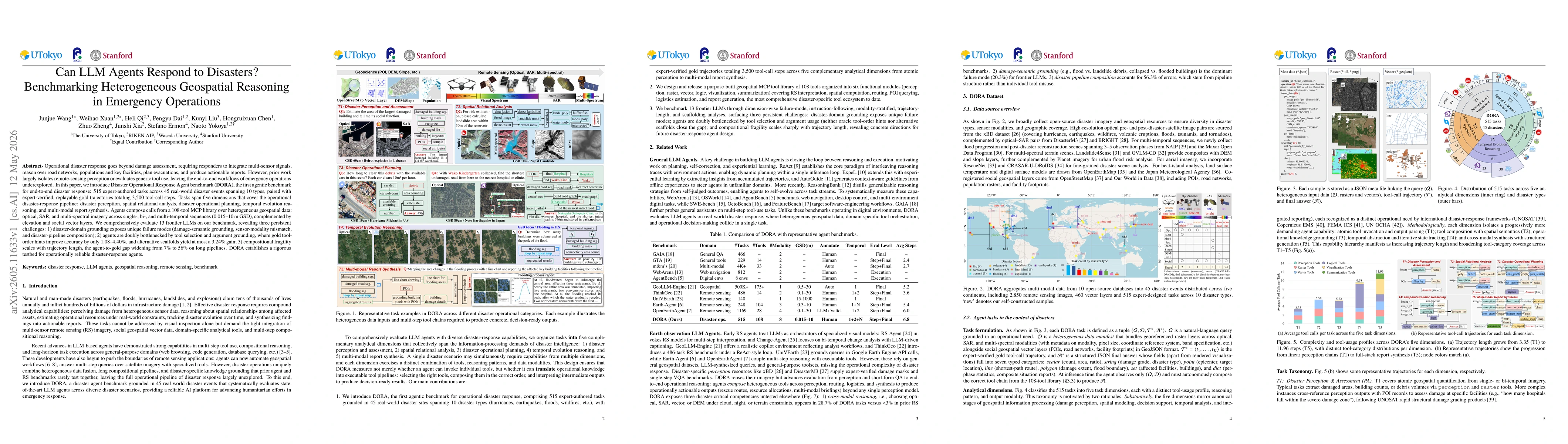
Operational disaster response goes beyond damage assessment, requiring responders to integrate multi-sensor signals, reason over road networks, populations and key facilities, plan evacuations, and pr...

This website uses cookies to ensure you get the best experience. Learn more