Academic Profile
Statistics
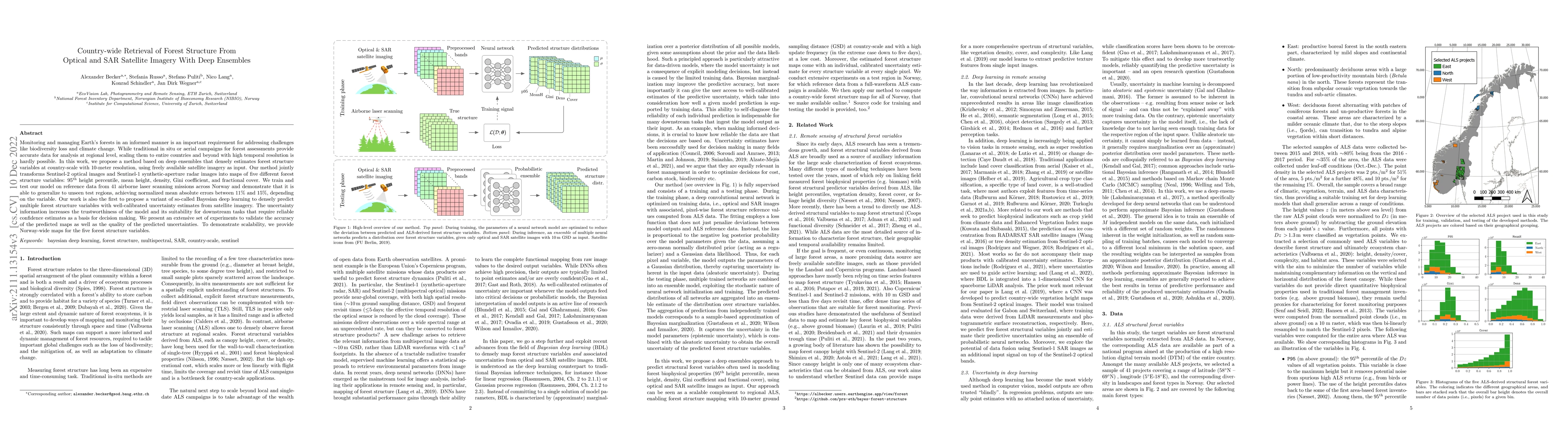
Similar Authors
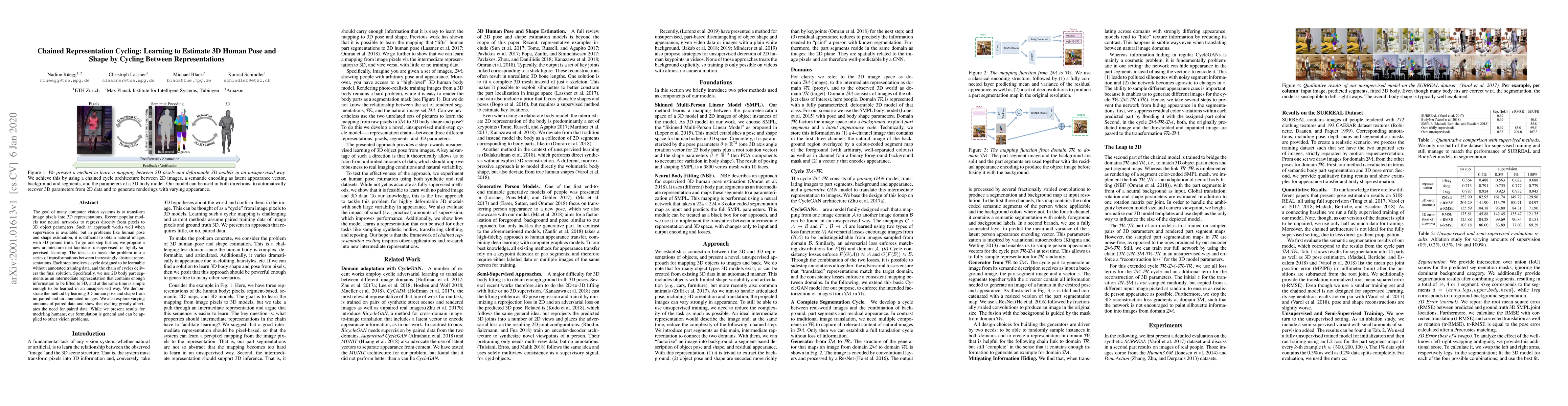
Papers on arXiv
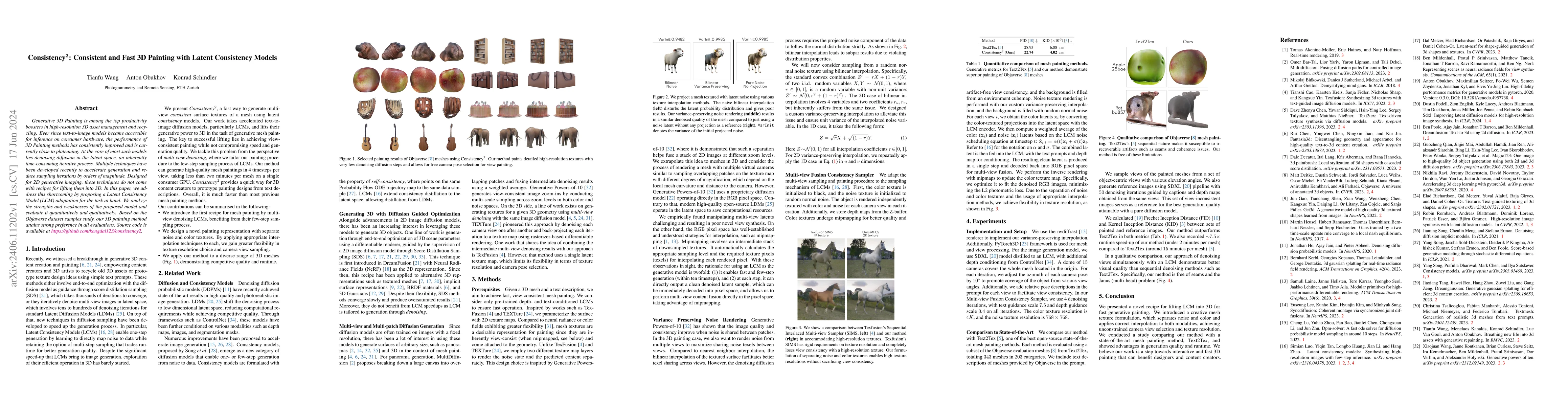
Generative 3D Painting is among the top productivity boosters in high-resolution 3D asset management and recycling. Ever since text-to-image models became accessible for inference on consumer hardware...
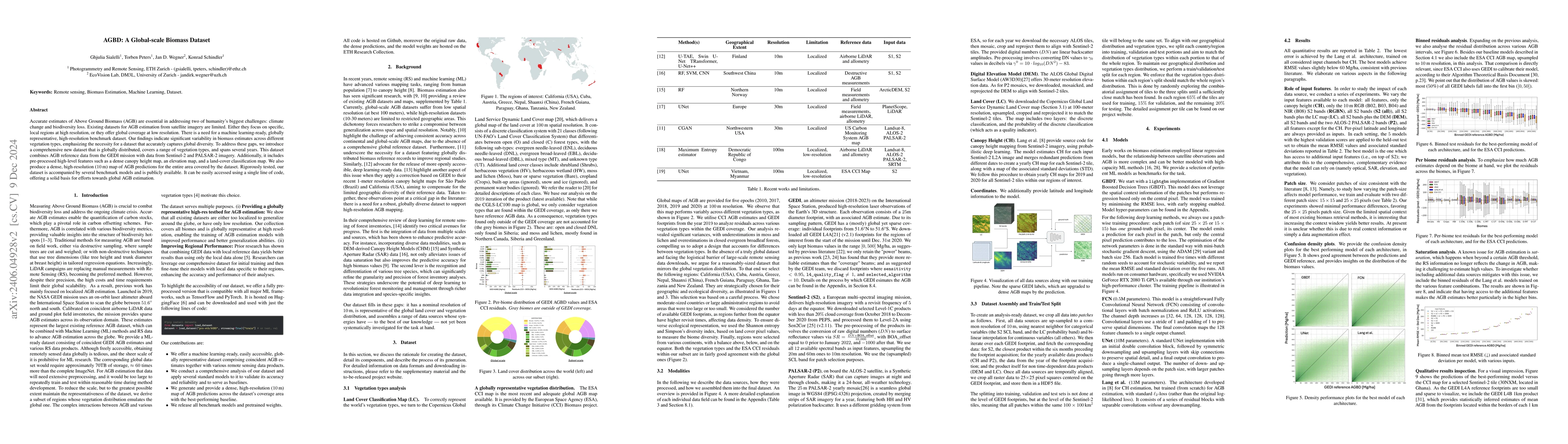
Accurate estimates of Above Ground Biomass (AGB) are essential in addressing two of humanity's biggest challenges, climate change and biodiversity loss. Existing datasets for AGB estimation from sat...
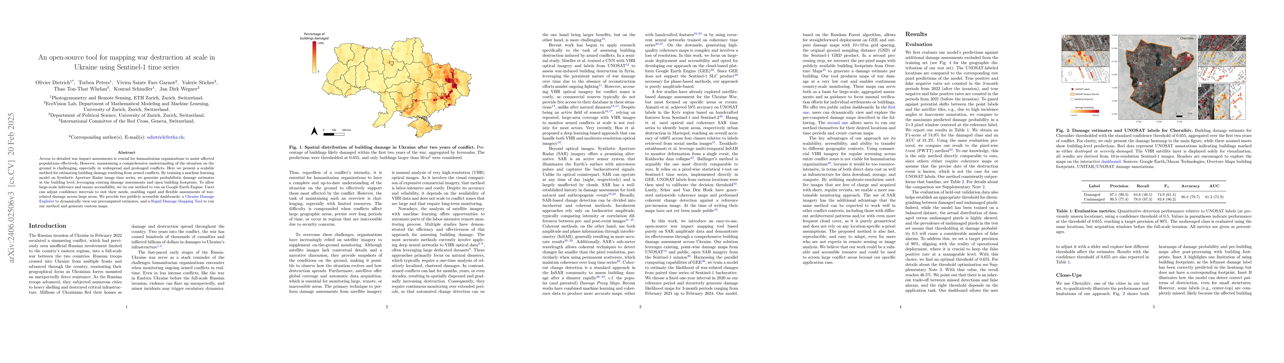
Access to detailed war impact assessments is crucial for humanitarian organizations to effectively assist populations most affected by armed conflicts. However, maintaining a comprehensive understan...
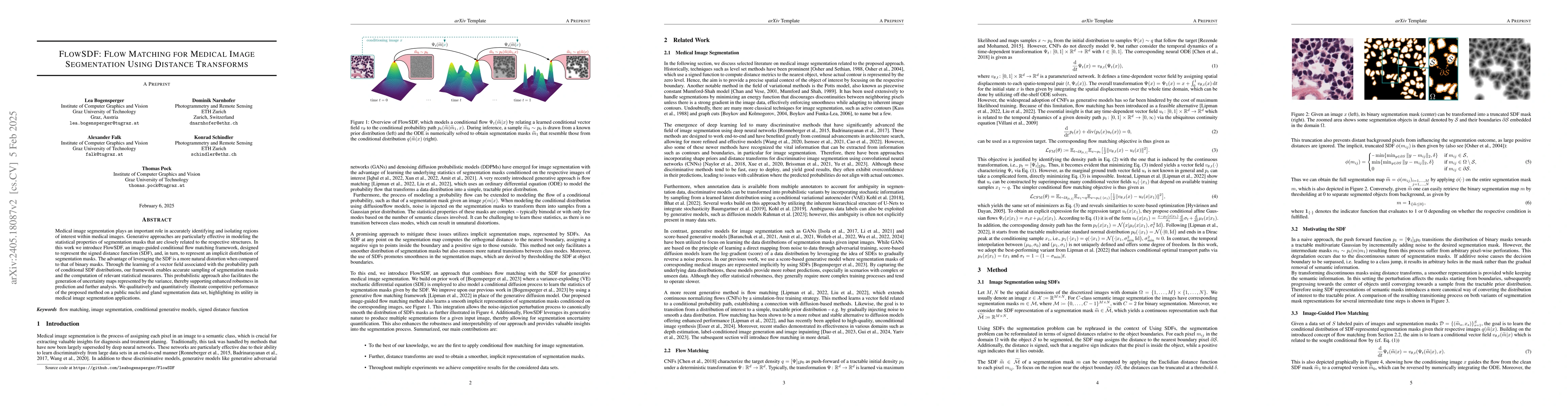
Medical image segmentation is a crucial task that relies on the ability to accurately identify and isolate regions of interest in medical images. Thereby, generative approaches allow to capture the ...
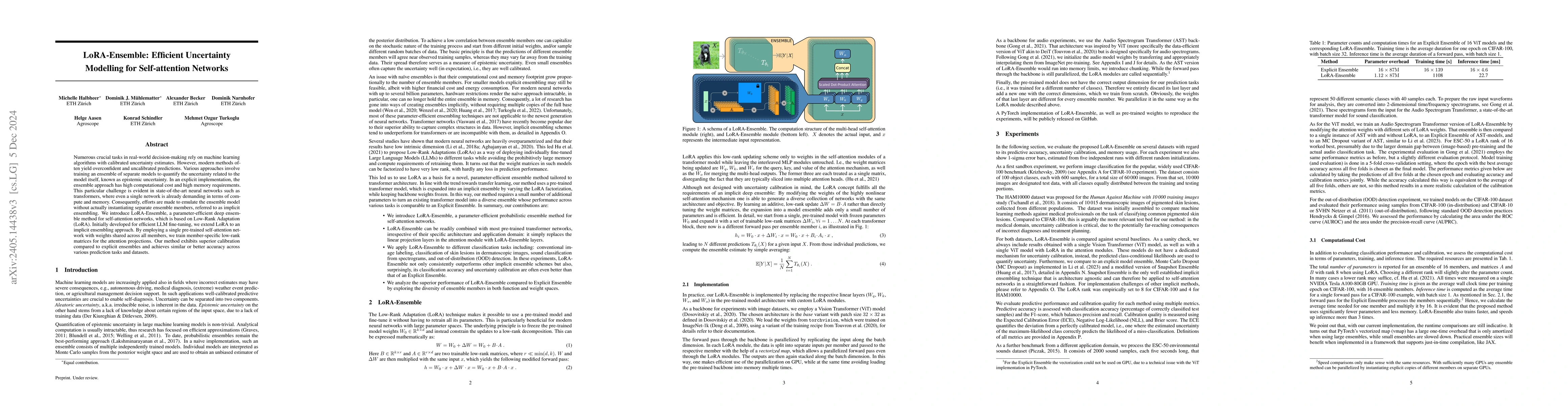
Numerous crucial tasks in real-world decision-making rely on machine learning algorithms with calibrated uncertainty estimates. However, modern methods often yield overconfident and uncalibrated pre...
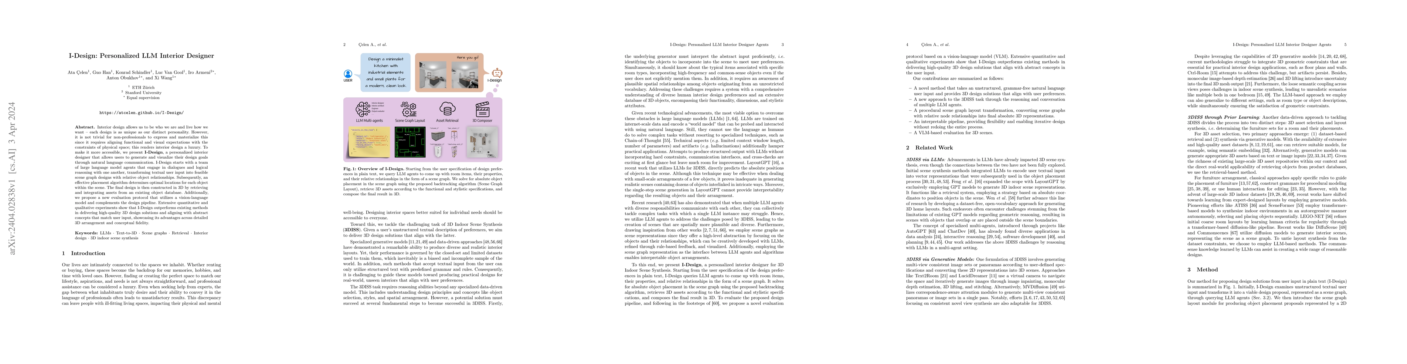
Interior design allows us to be who we are and live how we want - each design is as unique as our distinct personality. However, it is not trivial for non-professionals to express and materialize th...
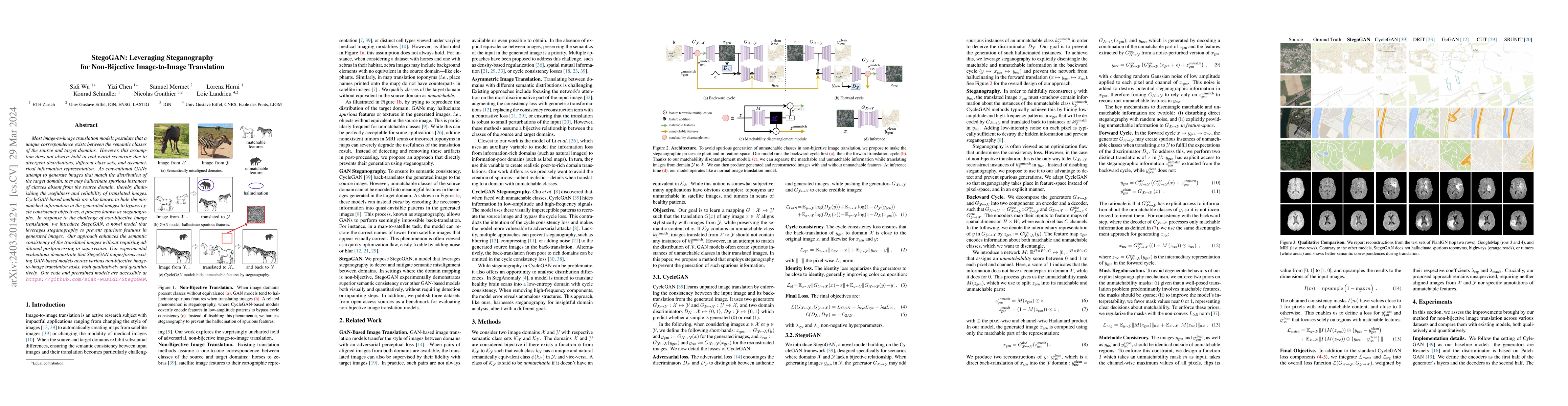
Most image-to-image translation models postulate that a unique correspondence exists between the semantic classes of the source and target domains. However, this assumption does not always hold in r...
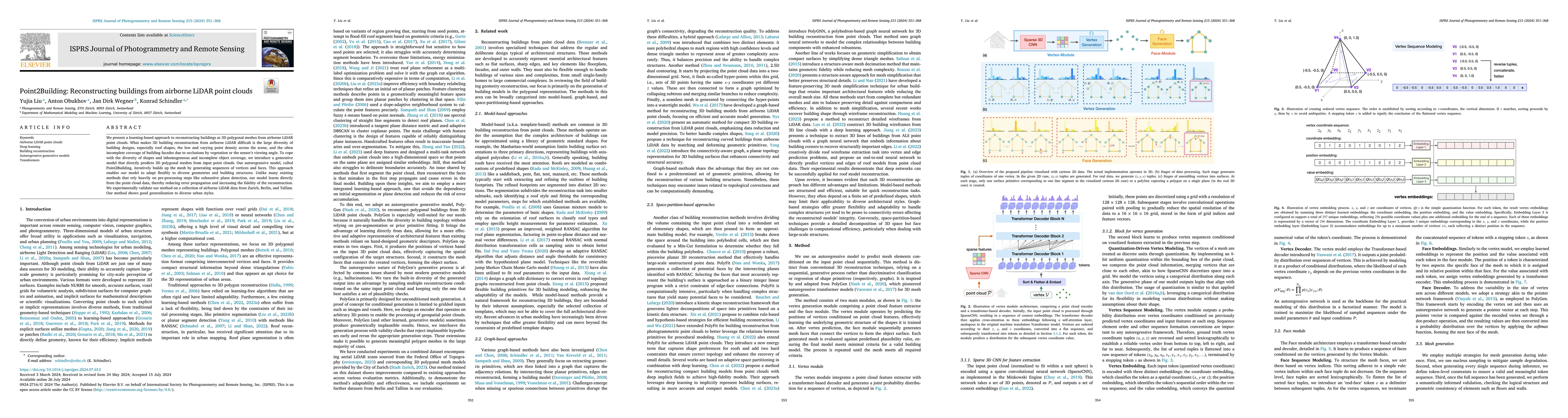
We present a learning-based approach to reconstruct buildings as 3D polygonal meshes from airborne LiDAR point clouds. What makes 3D building reconstruction from airborne LiDAR hard is the large div...
Despite continual learning's long and well-established academic history, its application in real-world scenarios remains rather limited. This paper contends that this gap is attributable to a misali...
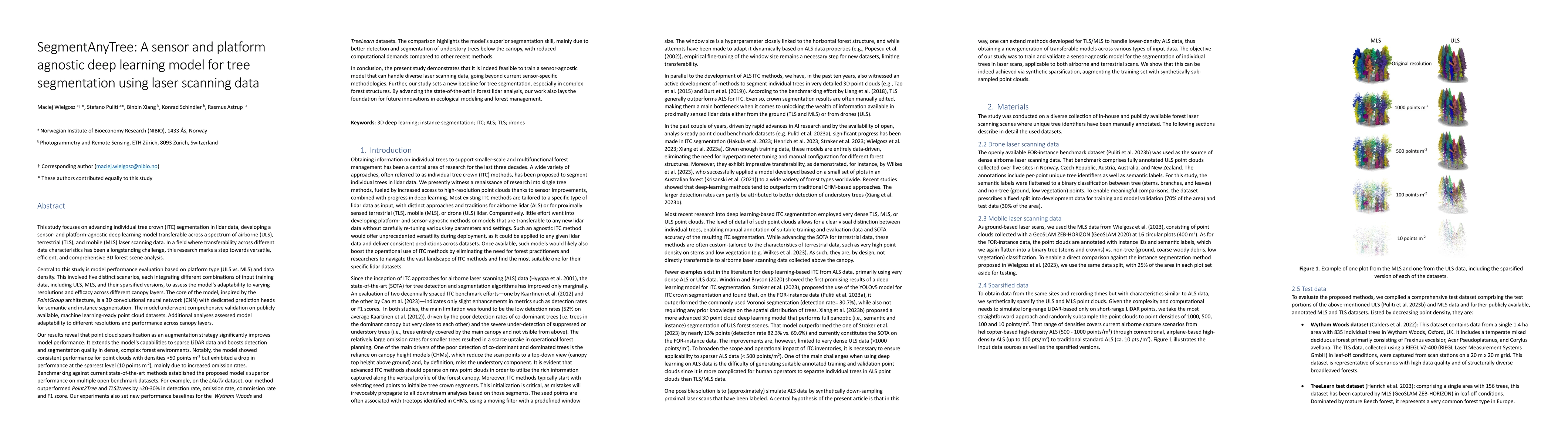
This research advances individual tree crown (ITC) segmentation in lidar data, using a deep learning model applicable to various laser scanning types: airborne (ULS), terrestrial (TLS), and mobile (...
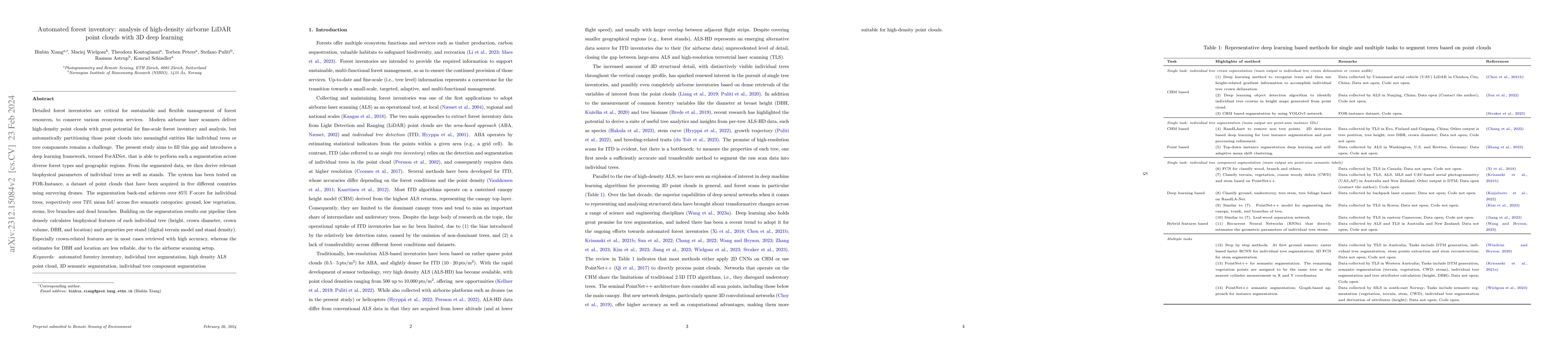
Detailed forest inventories are critical for sustainable and flexible management of forest resources, to conserve various ecosystem services. Modern airborne laser scanners deliver high-density poin...
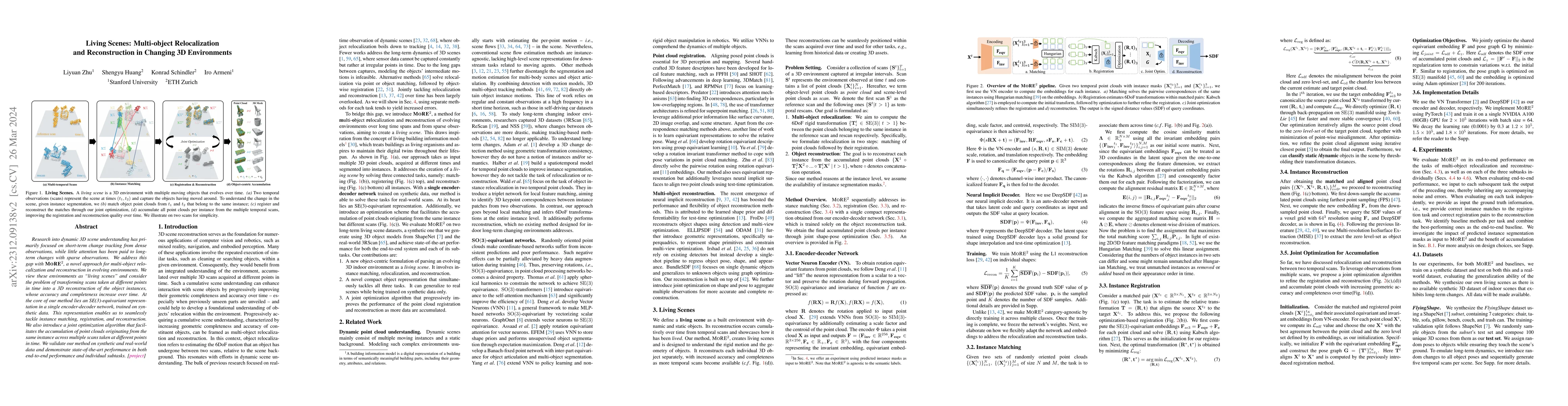
Research into dynamic 3D scene understanding has primarily focused on short-term change tracking from dense observations, while little attention has been paid to long-term changes with sparse observ...
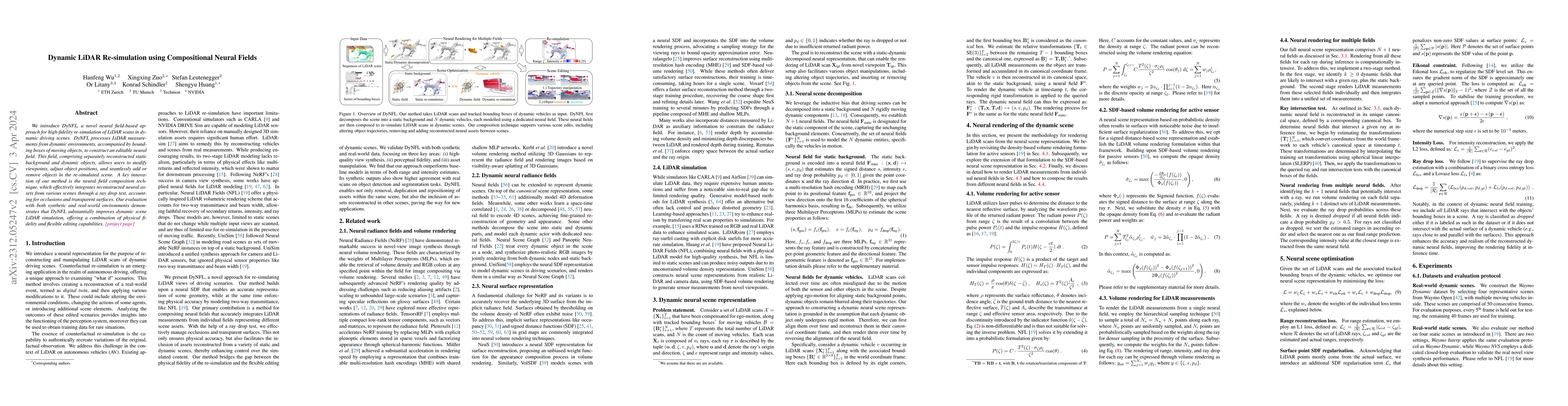
We introduce DyNFL, a novel neural field-based approach for high-fidelity re-simulation of LiDAR scans in dynamic driving scenes. DyNFL processes LiDAR measurements from dynamic environments, accomp...
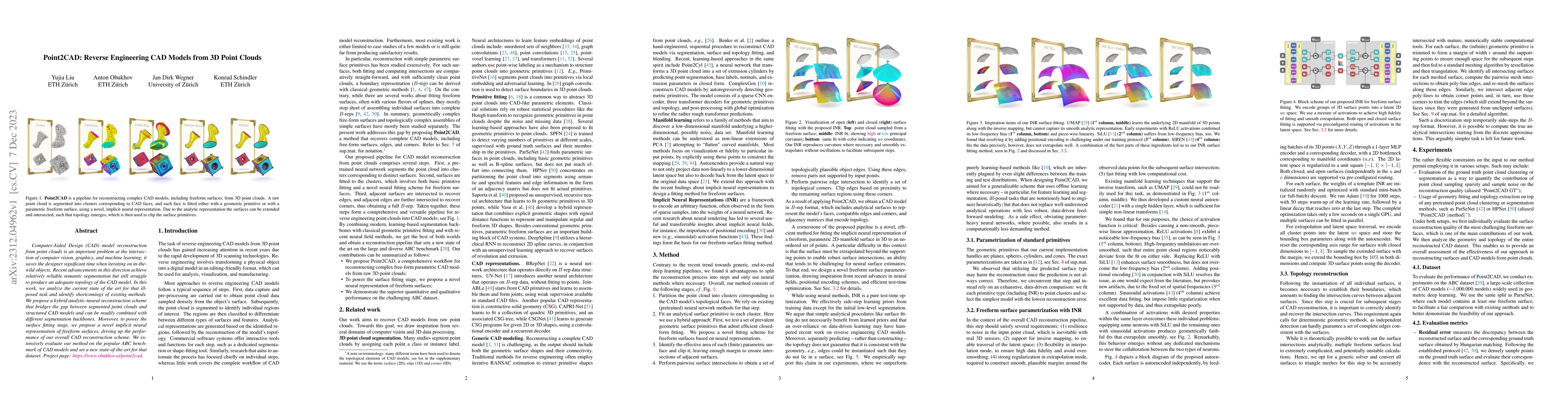
Computer-Aided Design (CAD) model reconstruction from point clouds is an important problem at the intersection of computer vision, graphics, and machine learning; it saves the designer significant t...
Large, pretrained latent diffusion models (LDMs) have demonstrated an extraordinary ability to generate creative content, specialize to user data through few-shot fine-tuning, and condition their ou...
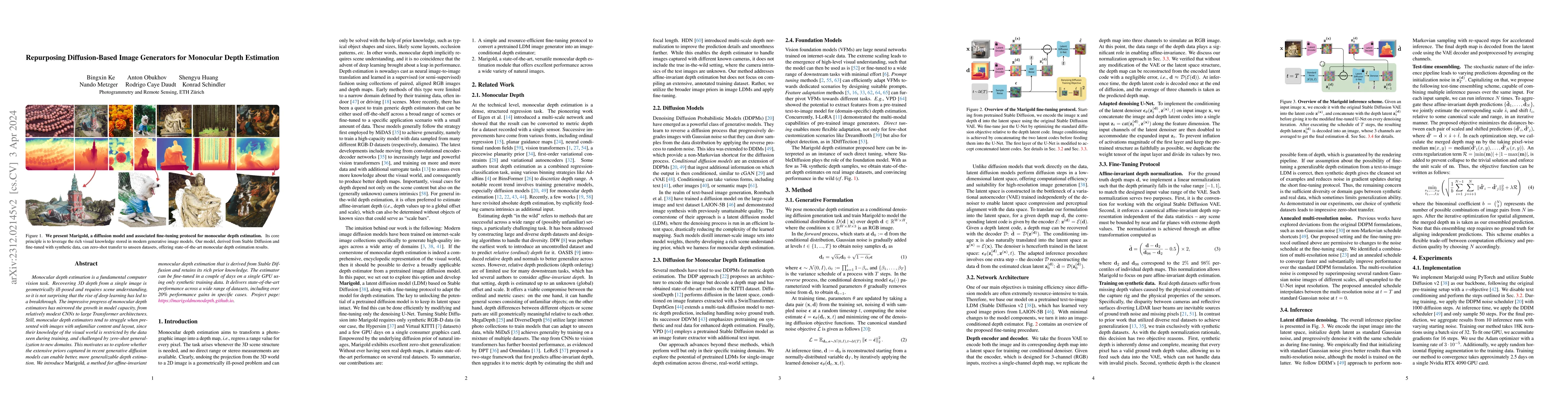
Monocular depth estimation is a fundamental computer vision task. Recovering 3D depth from a single image is geometrically ill-posed and requires scene understanding, so it is not surprising that th...
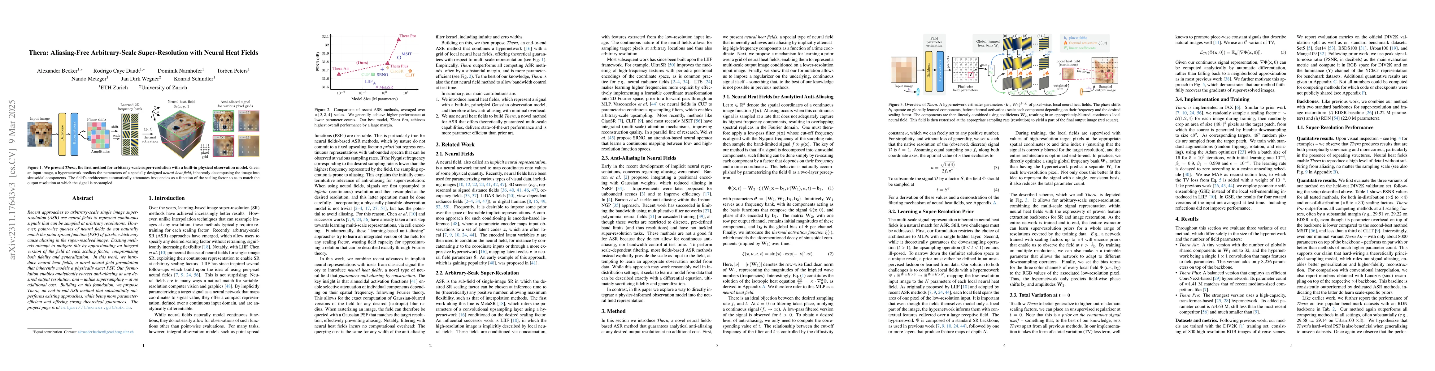
Recent approaches for arbitrary-scale single image super-resolution (ASSR) have used local neural fields to represent continuous signals that can be sampled at arbitrary rates. However, the point-wi...
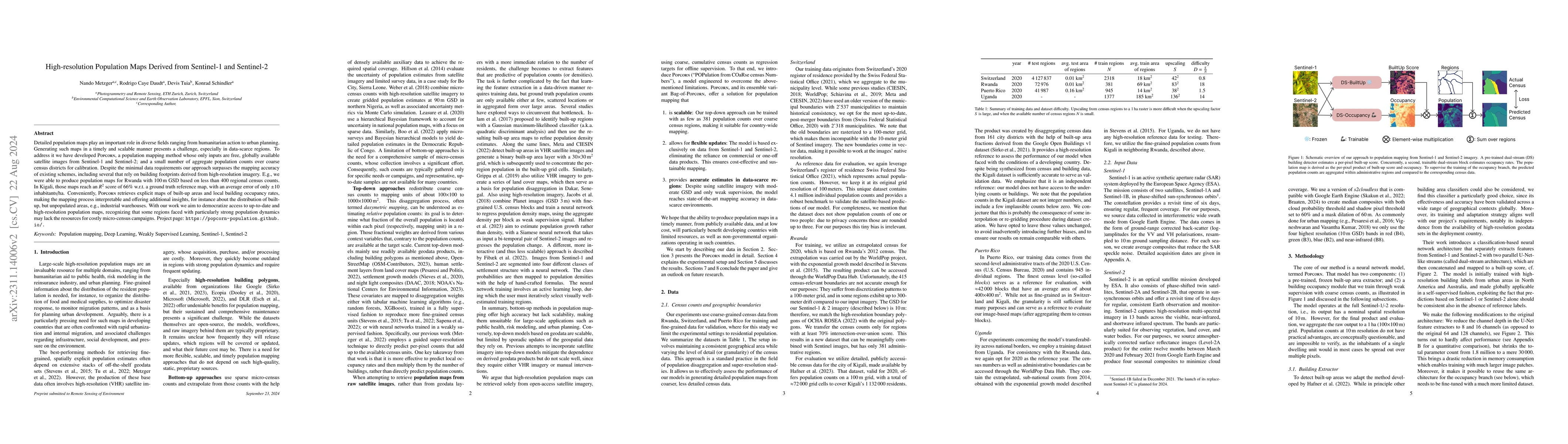
Detailed population maps play an important role in diverse fields ranging from humanitarian action to urban planning. Generating such maps in a timely and scalable manner presents a challenge, espec...
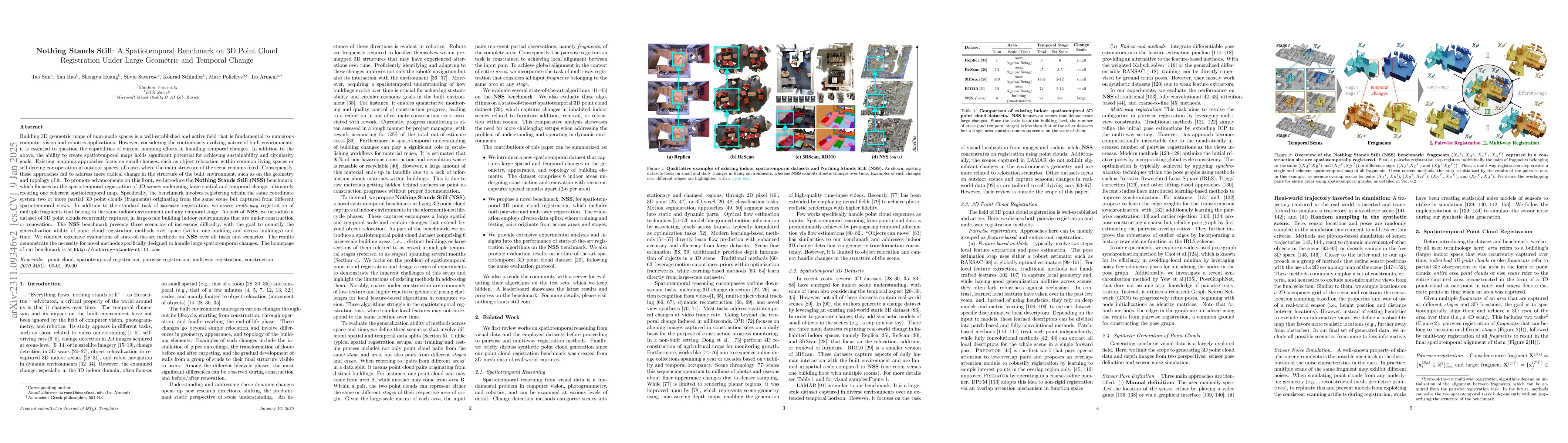
Building 3D geometric maps of man-made spaces is a well-established and active field that is fundamental to computer vision and robotics. However, considering the evolving nature of built environmen...
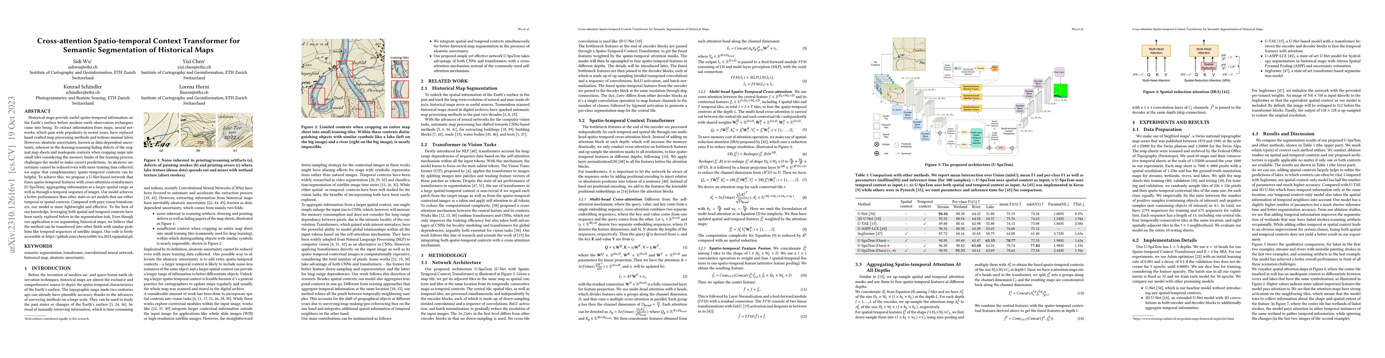
Historical maps provide useful spatio-temporal information on the Earth's surface before modern earth observation techniques came into being. To extract information from maps, neural networks, which...
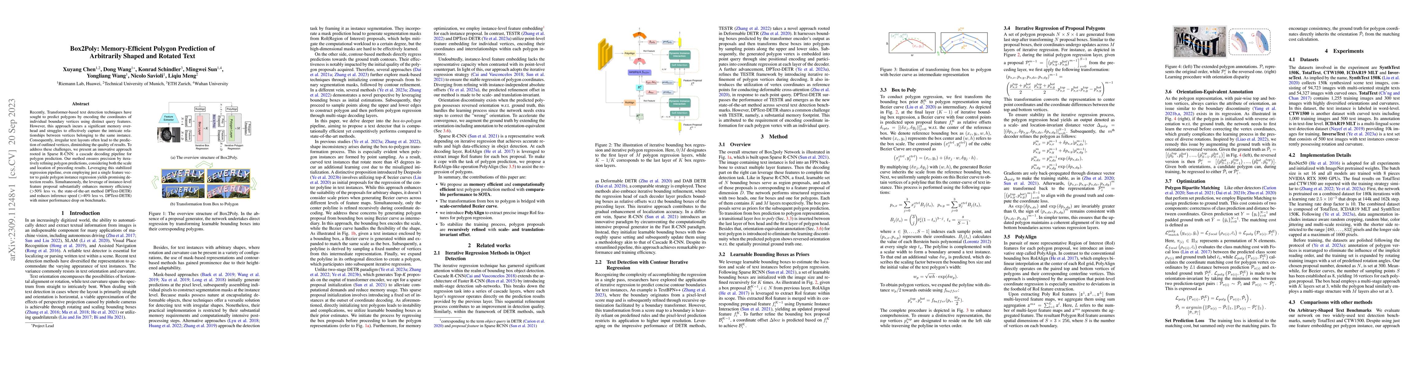
Recently, Transformer-based text detection techniques have sought to predict polygons by encoding the coordinates of individual boundary vertices using distinct query features. However, this approac...
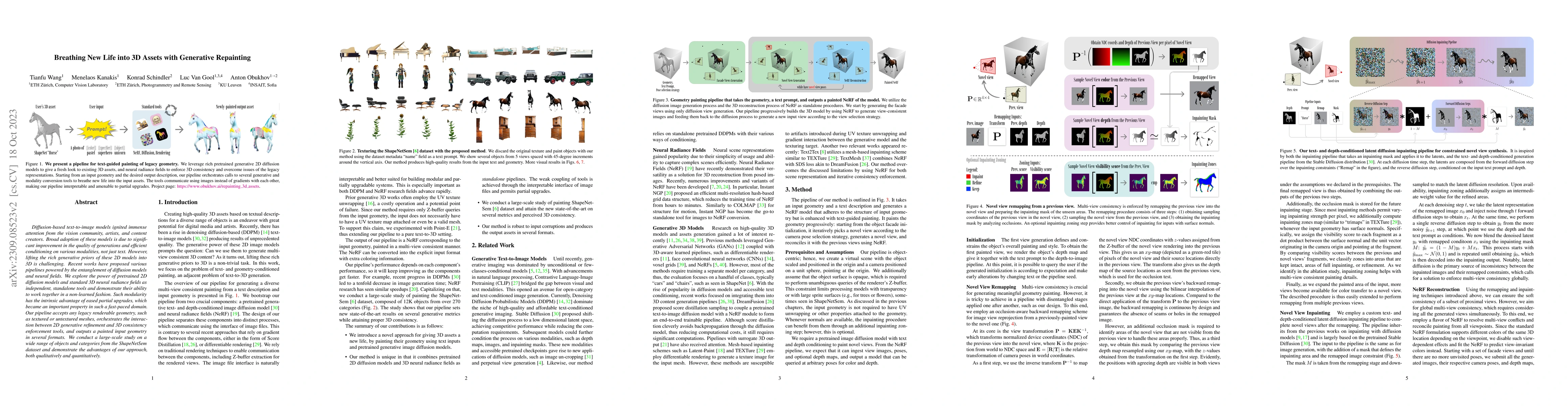
Diffusion-based text-to-image models ignited immense attention from the vision community, artists, and content creators. Broad adoption of these models is due to significant improvement in the quali...
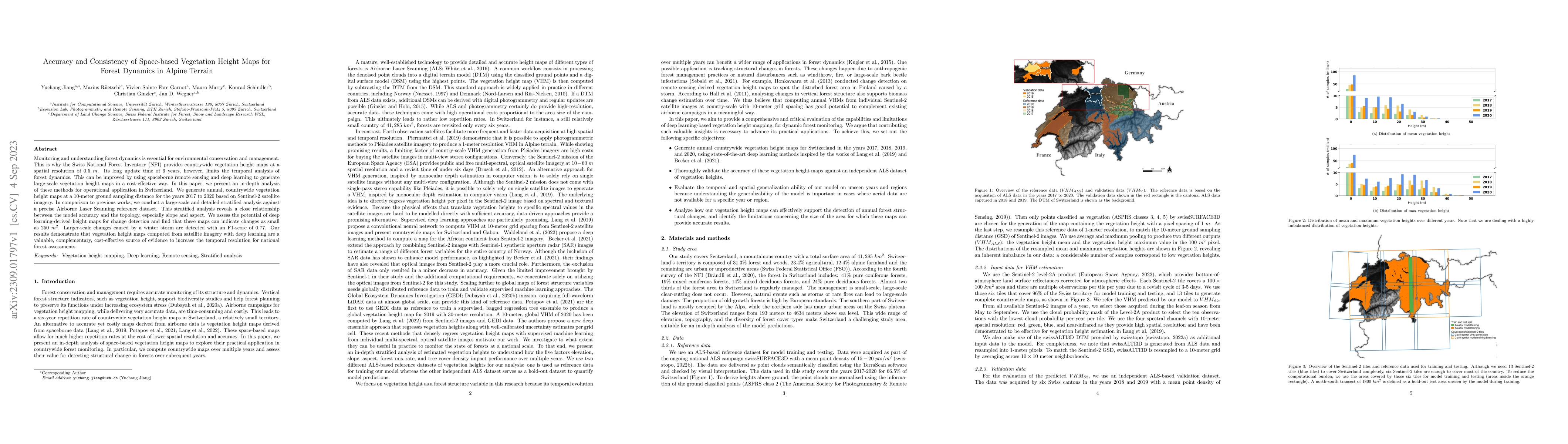
Monitoring and understanding forest dynamics is essential for environmental conservation and management. This is why the Swiss National Forest Inventory (NFI) provides countrywide vegetation height ...
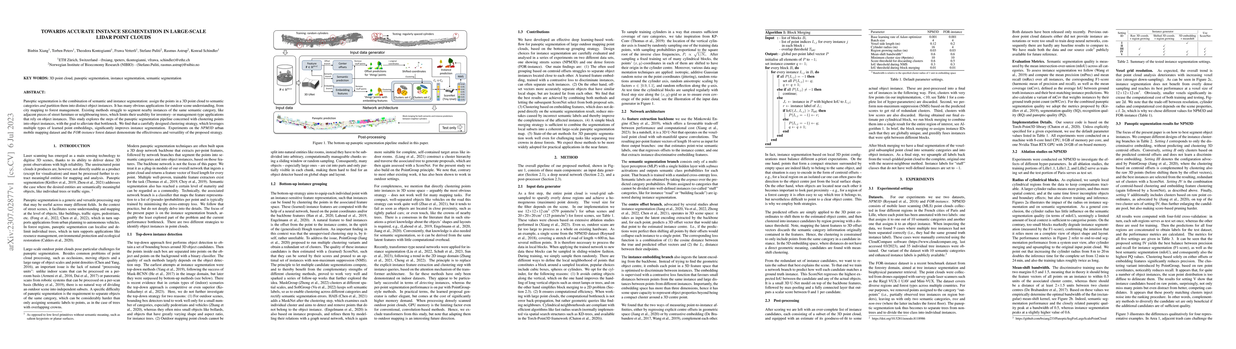
Panoptic segmentation is the combination of semantic and instance segmentation: assign the points in a 3D point cloud to semantic categories and partition them into distinct object instances. It has...
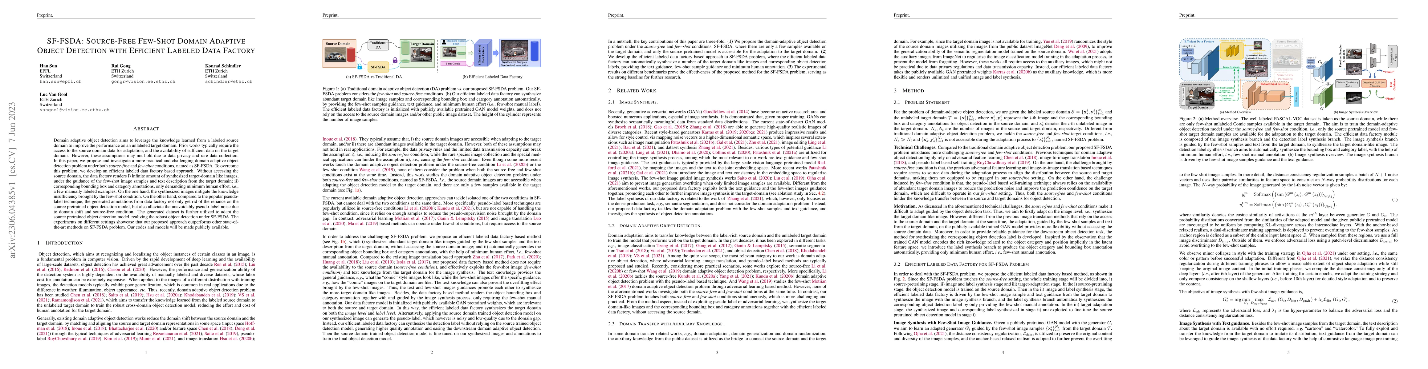
Domain adaptive object detection aims to leverage the knowledge learned from a labeled source domain to improve the performance on an unlabeled target domain. Prior works typically require the acces...
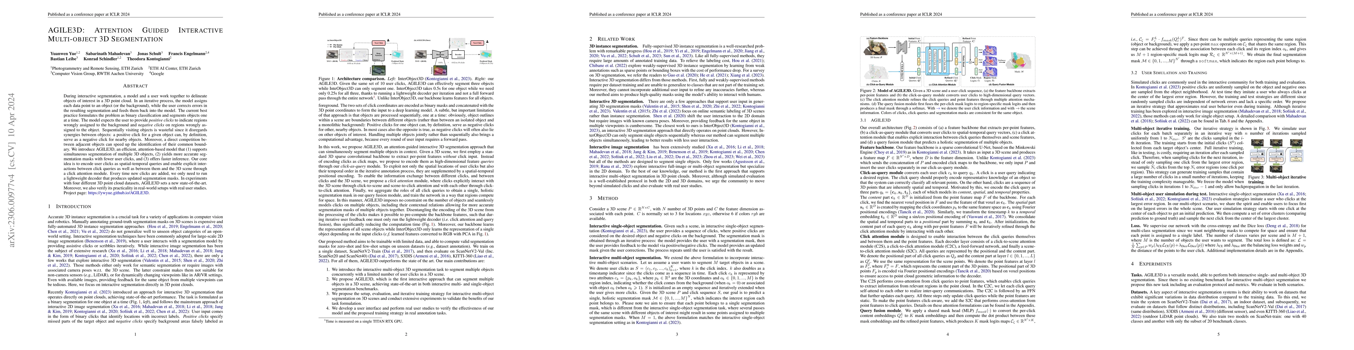
During interactive segmentation, a model and a user work together to delineate objects of interest in a 3D point cloud. In an iterative process, the model assigns each data point to an object (or th...
Data imbalance is ubiquitous when applying machine learning to real-world problems, particularly regression problems. If training data are imbalanced, the learning is dominated by the densely covere...
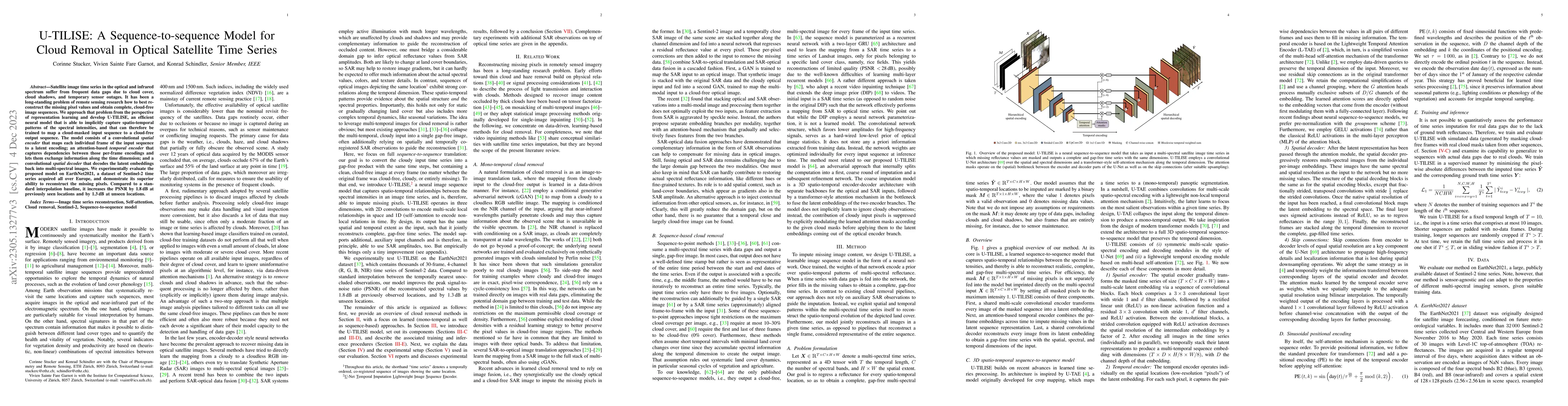
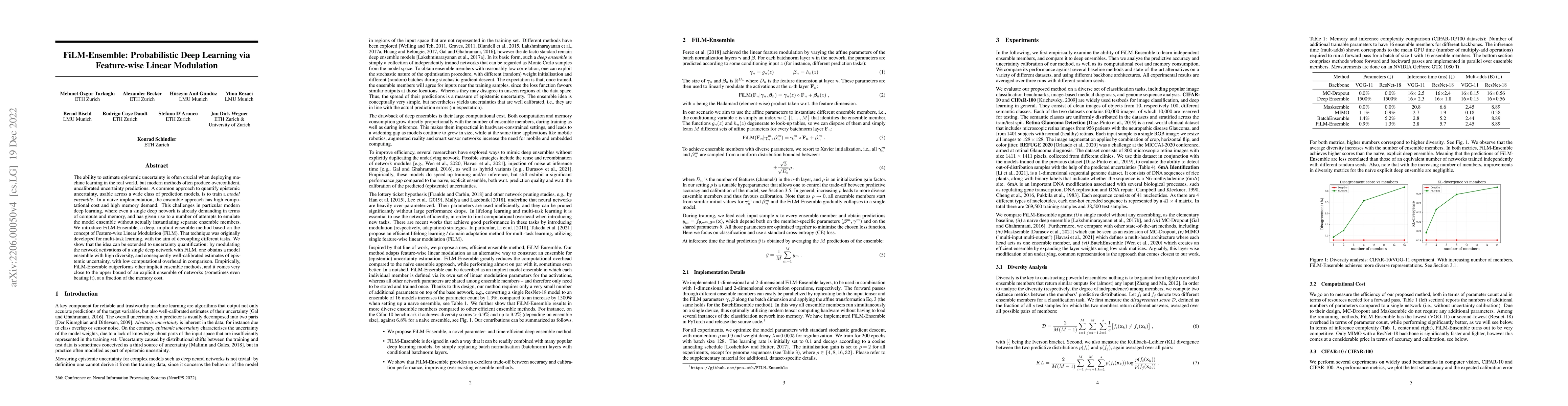
Satellite image time series in the optical and infrared spectrum suffer from frequent data gaps due to cloud cover, cloud shadows, and temporary sensor outages. It has been a long-standing problem o...
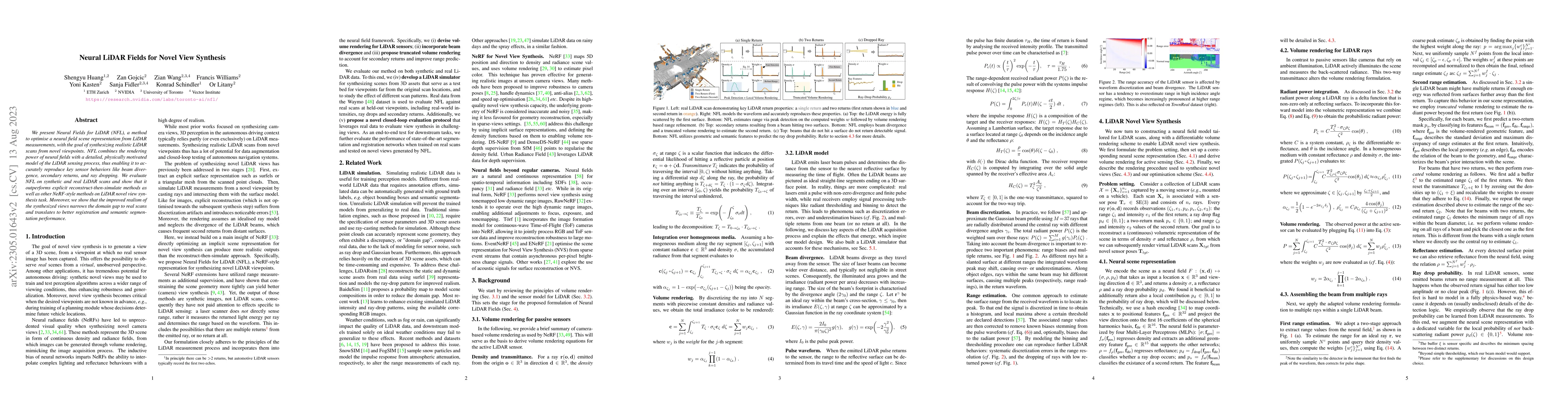
We present Neural Fields for LiDAR (NFL), a method to optimise a neural field scene representation from LiDAR measurements, with the goal of synthesizing realistic LiDAR scans from novel viewpoints....
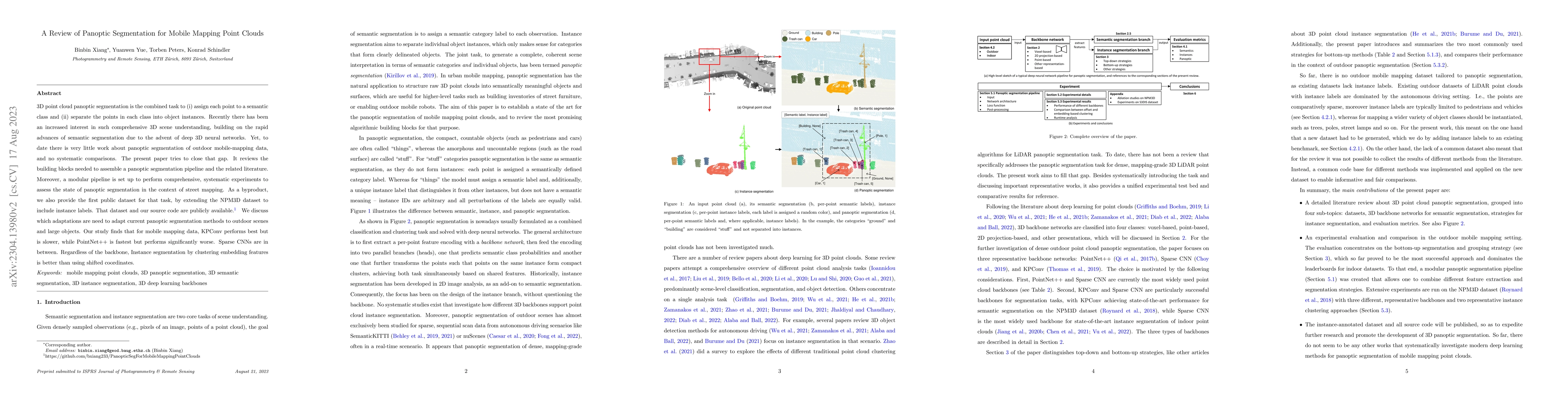
3D point cloud panoptic segmentation is the combined task to (i) assign each point to a semantic class and (ii) separate the points in each class into object instances. Recently there has been an in...
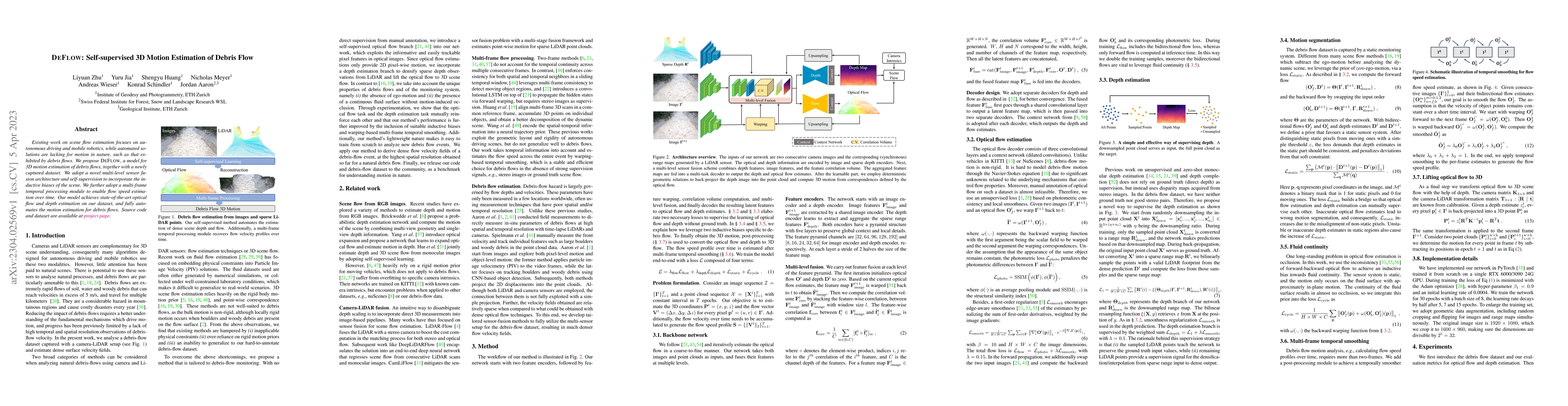
Existing work on scene flow estimation focuses on autonomous driving and mobile robotics, while automated solutions are lacking for motion in nature, such as that exhibited by debris flows. We propo...
Accurate activity location prediction is a crucial component of many mobility applications and is particularly required to develop personalized, sustainable transportation systems. Despite the wides...
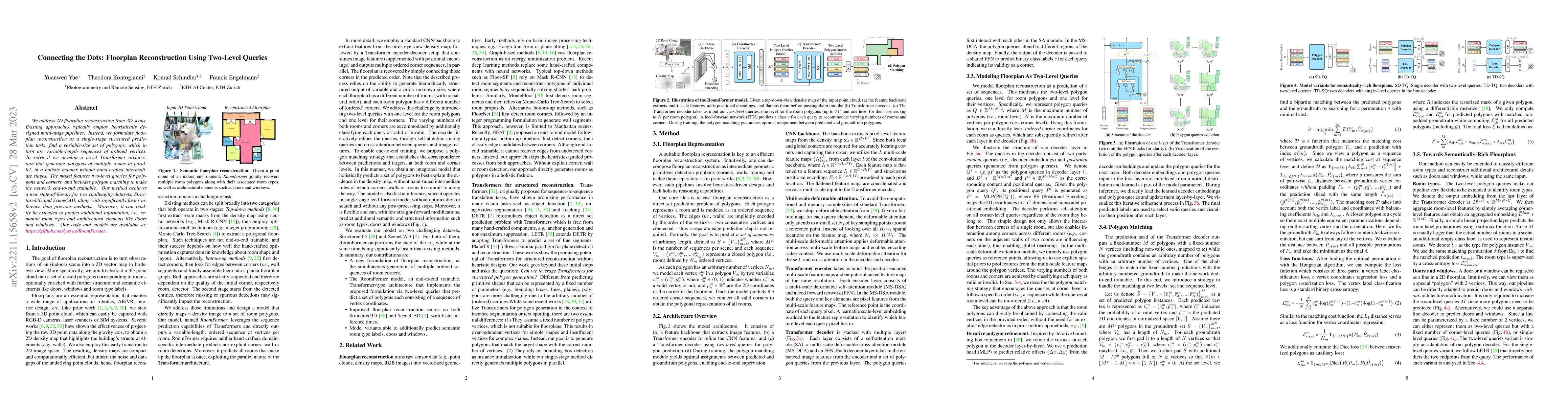
We address 2D floorplan reconstruction from 3D scans. Existing approaches typically employ heuristically designed multi-stage pipelines. Instead, we formulate floorplan reconstruction as a single-st...
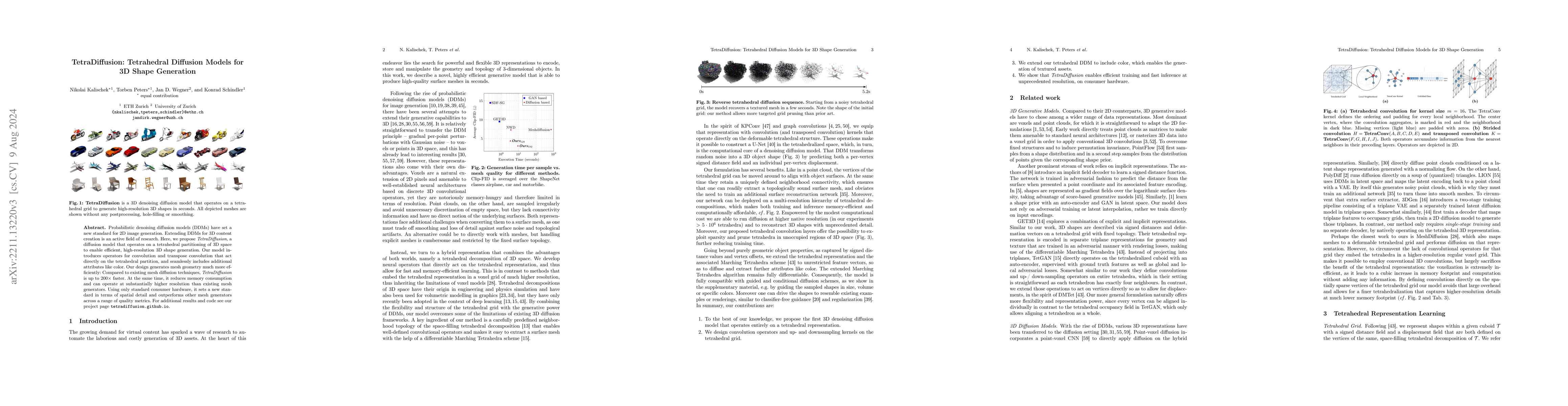
Probabilistic denoising diffusion models (DDMs) have set a new standard for 2D image generation. Extending DDMs for 3D content creation is an active field of research. Here, we propose TetraDiffusio...
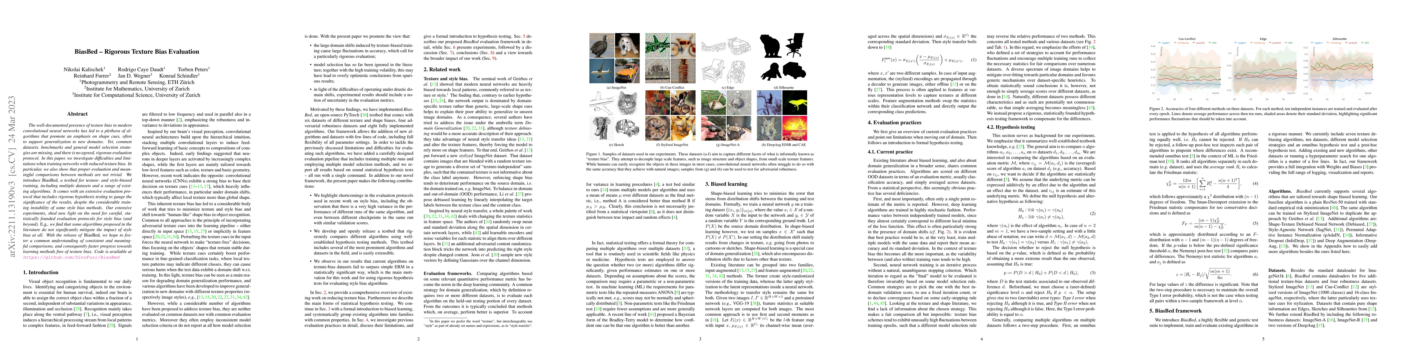
The well-documented presence of texture bias in modern convolutional neural networks has led to a plethora of algorithms that promote an emphasis on shape cues, often to support generalization to ne...
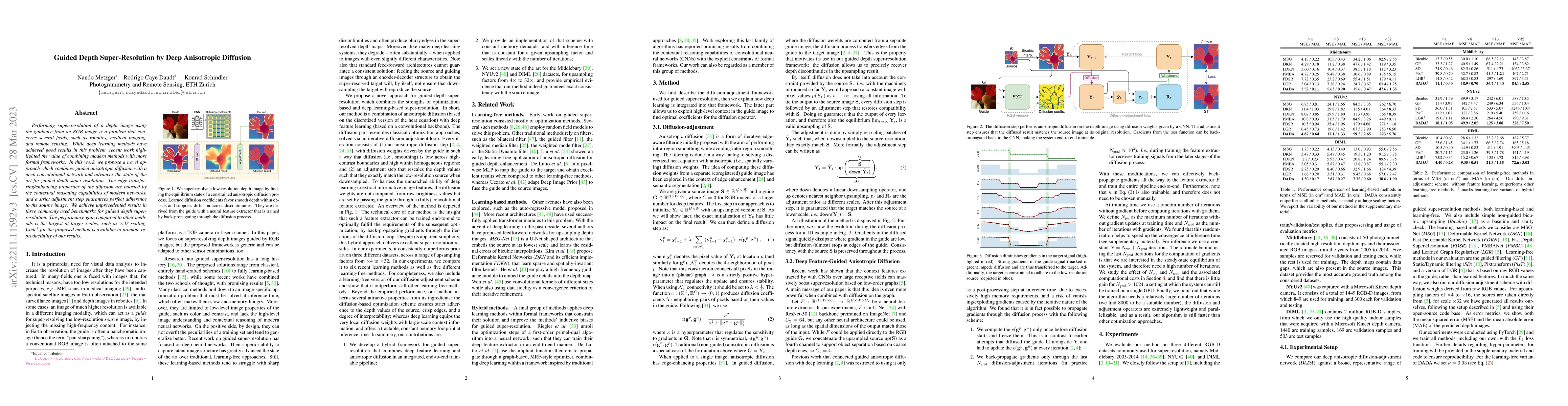
Performing super-resolution of a depth image using the guidance from an RGB image is a problem that concerns several fields, such as robotics, medical imaging, and remote sensing. While deep learnin...
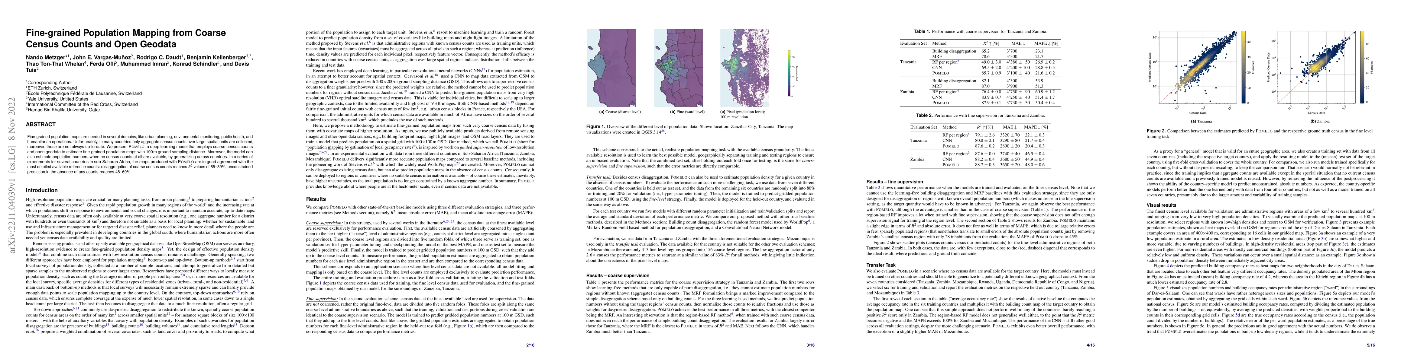
Fine-grained population maps are needed in several domains, like urban planning, environmental monitoring, public health, and humanitarian operations. Unfortunately, in many countries only aggregate...
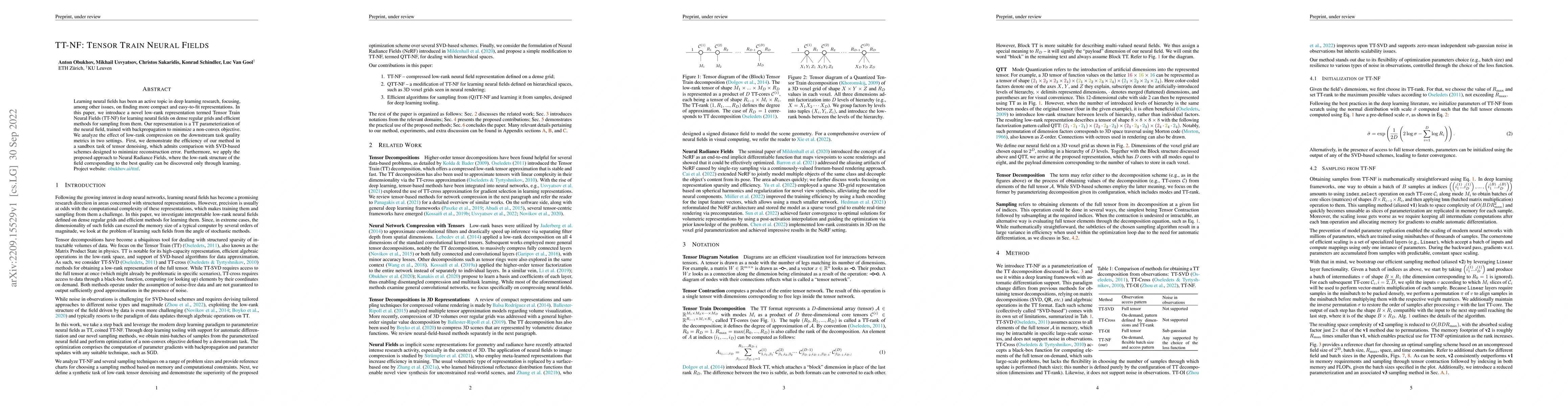
Learning neural fields has been an active topic in deep learning research, focusing, among other issues, on finding more compact and easy-to-fit representations. In this paper, we introduce a novel ...
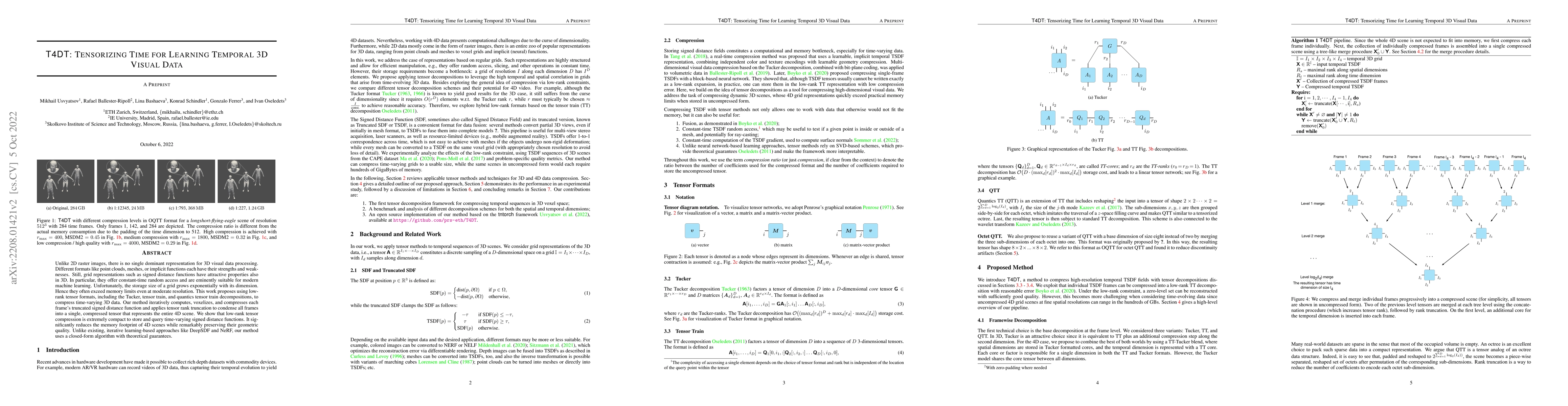
Unlike 2D raster images, there is no single dominant representation for 3D visual data processing. Different formats like point clouds, meshes, or implicit functions each have their strengths and we...
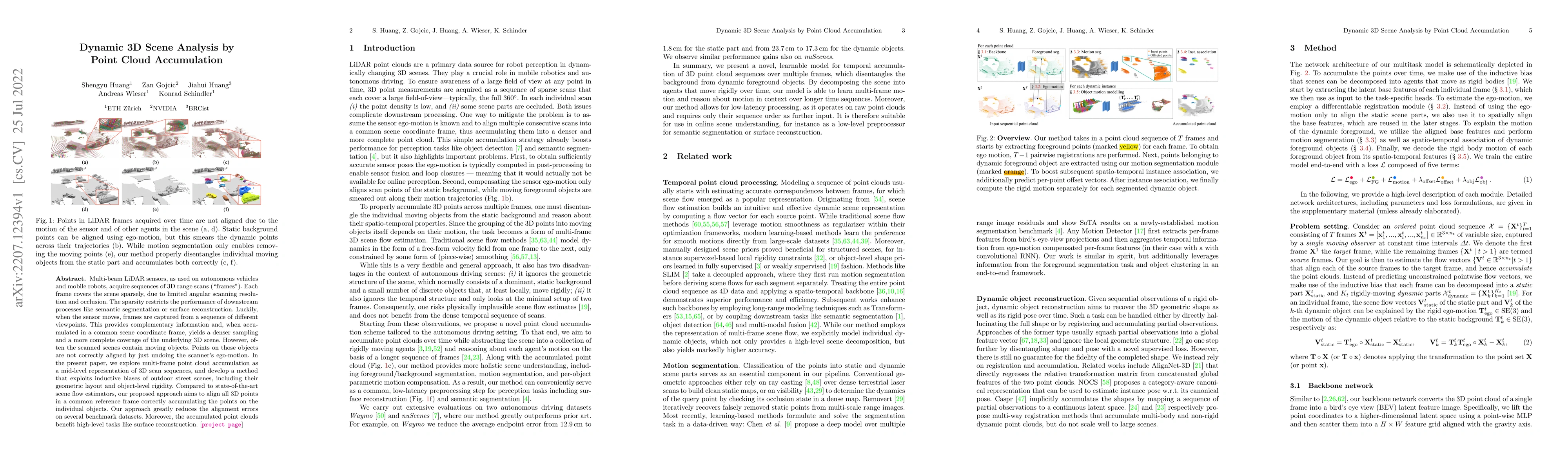
Multi-beam LiDAR sensors, as used on autonomous vehicles and mobile robots, acquire sequences of 3D range scans ("frames"). Each frame covers the scene sparsely, due to limited angular scanning reso...
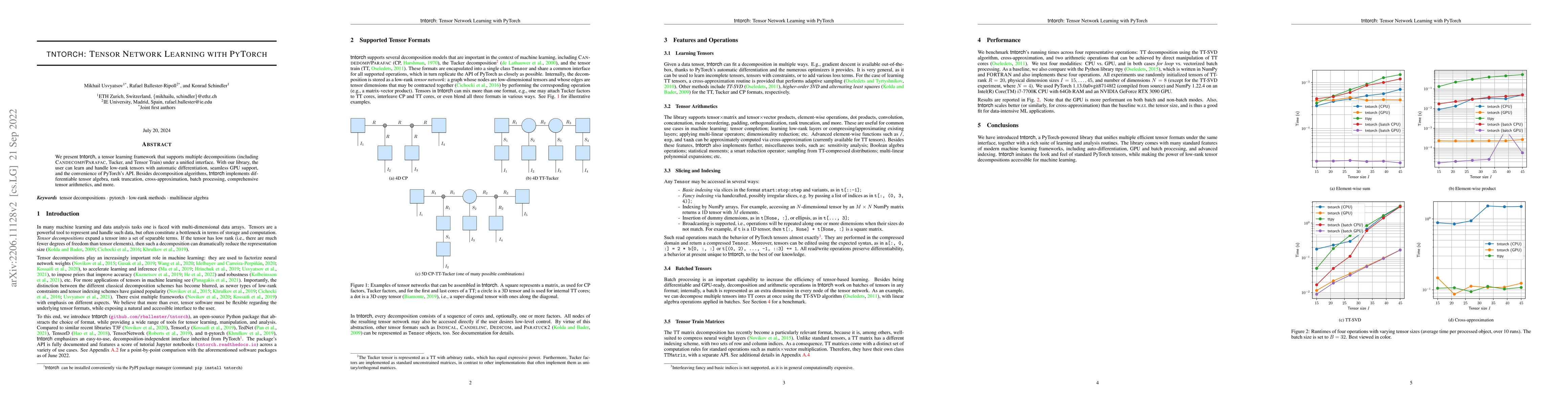
We present tntorch, a tensor learning framework that supports multiple decompositions (including Candecomp/Parafac, Tucker, and Tensor Train) under a unified interface. With our library, the user ca...
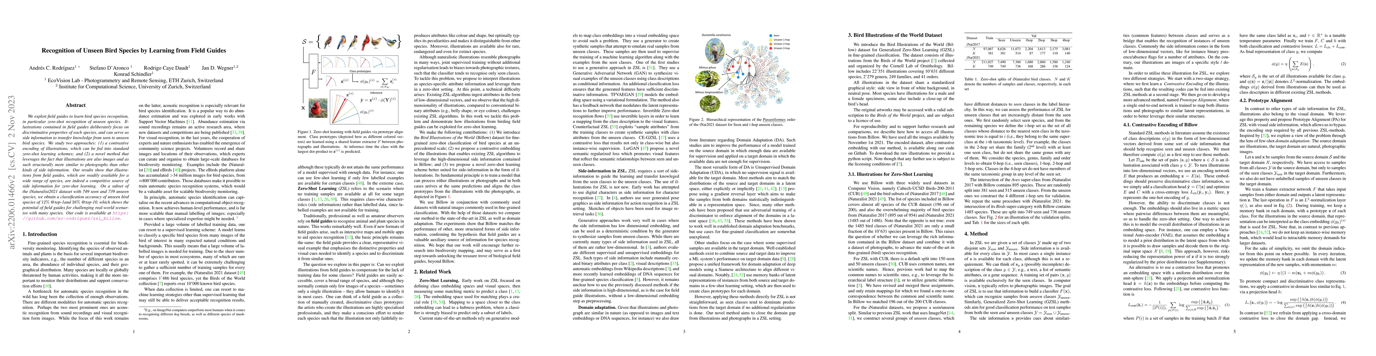
We exploit field guides to learn bird species recognition, in particular zero-shot recognition of unseen species. Illustrations contained in field guides deliberately focus on discriminative propert...
The ability to estimate epistemic uncertainty is often crucial when deploying machine learning in the real world, but modern methods often produce overconfident, uncalibrated uncertainty predictions...
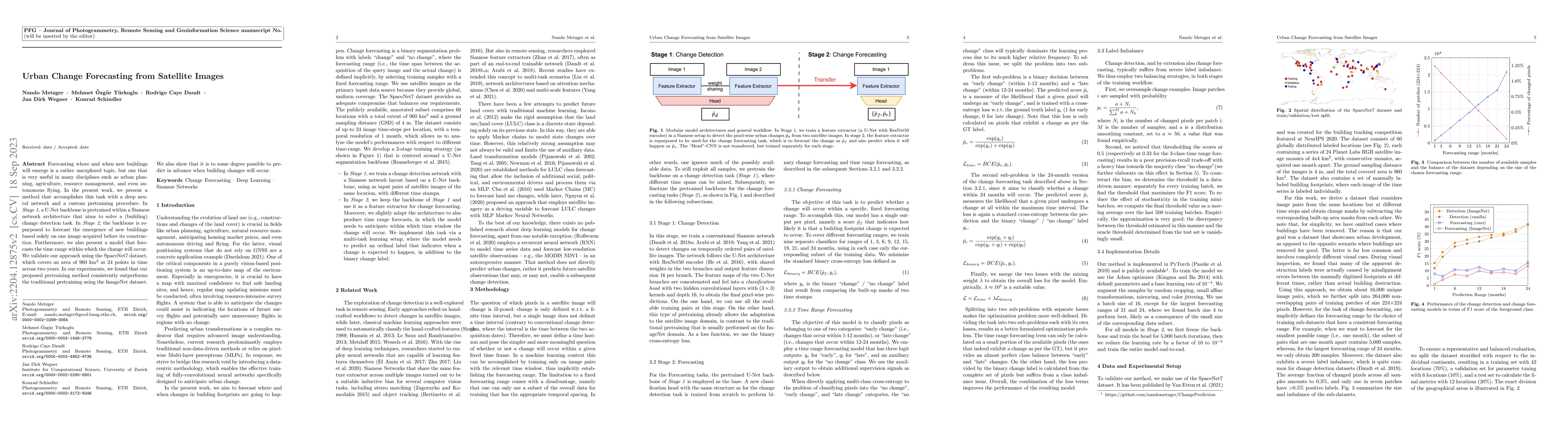
Forecasting where and when new buildings will emerge is a rather unexplored topic, but one that is very useful in many disciplines such as urban planning, agriculture, resource management, and even ...
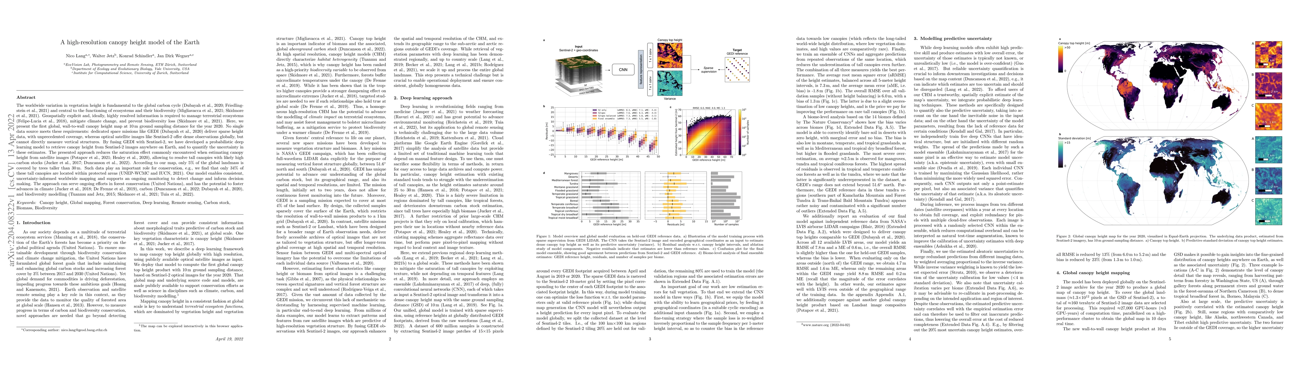
The worldwide variation in vegetation height is fundamental to the global carbon cycle and central to the functioning of ecosystems and their biodiversity. Geospatially explicit and, ideally, highly...
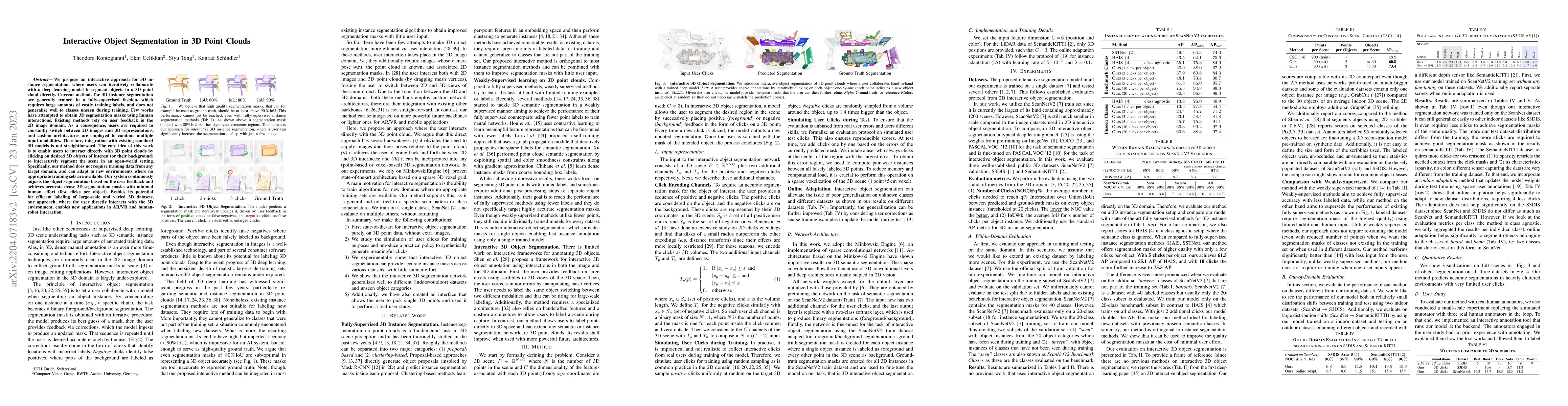
We propose an interactive approach for 3D instance segmentation, where users can iteratively collaborate with a deep learning model to segment objects in a 3D point cloud directly. Current methods f...
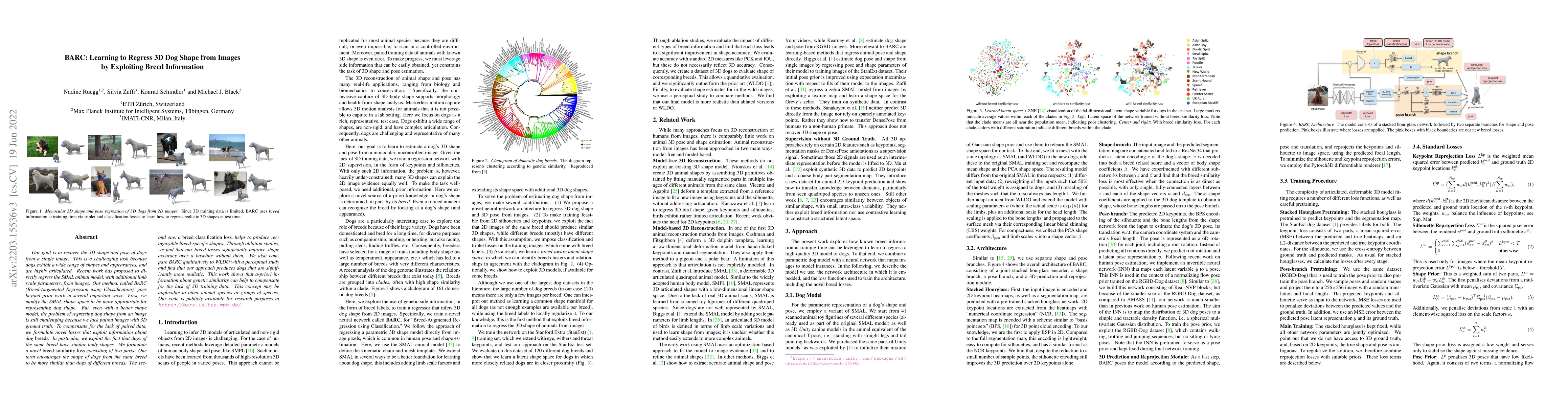
Our goal is to recover the 3D shape and pose of dogs from a single image. This is a challenging task because dogs exhibit a wide range of shapes and appearances, and are highly articulated. Recent w...
We introduce a novel formulation for guided super-resolution. Its core is a differentiable optimisation layer that operates on a learned affinity graph. The learned graph potentials make it possible...
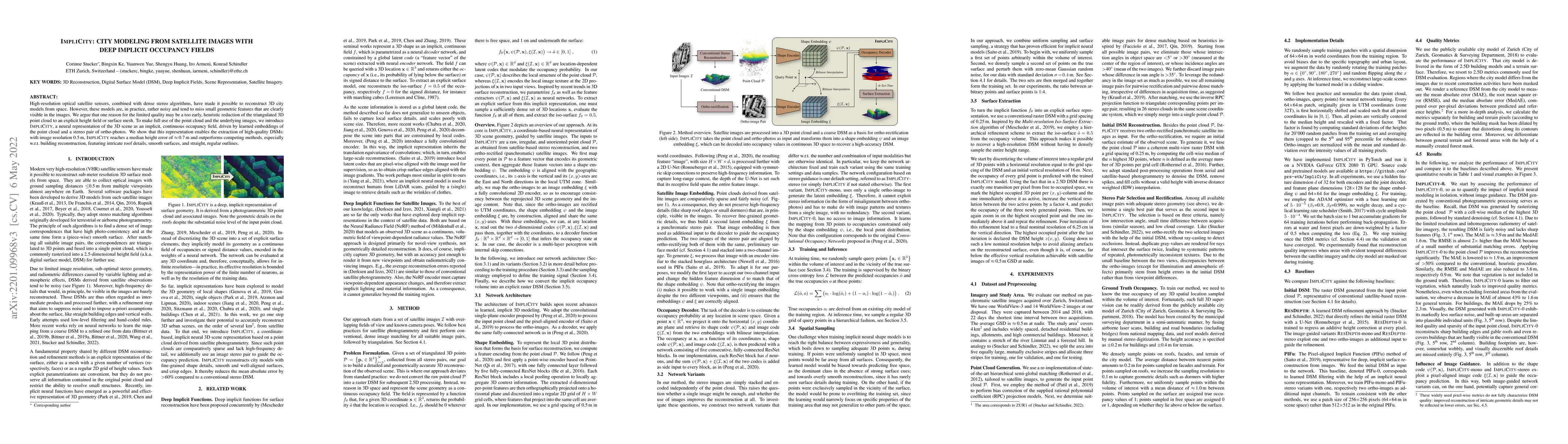
High-resolution optical satellite sensors, combined with dense stereo algorithms, have made it possible to reconstruct 3D city models from space. However, these models are, in practice, rather noisy...
Monitoring and managing Earth's forests in an informed manner is an important requirement for addressing challenges like biodiversity loss and climate change. While traditional in situ or aerial cam...
We investigate the possibility of 3D scene reconstruction from two or more overlapping webcam streams. A large, and growing, number of webcams observe places of interest and are publicly accessible....
Humanitarian actions require accurate information to efficiently delegate support operations. Such information can be maps of building footprints, building functions, and population densities. While...
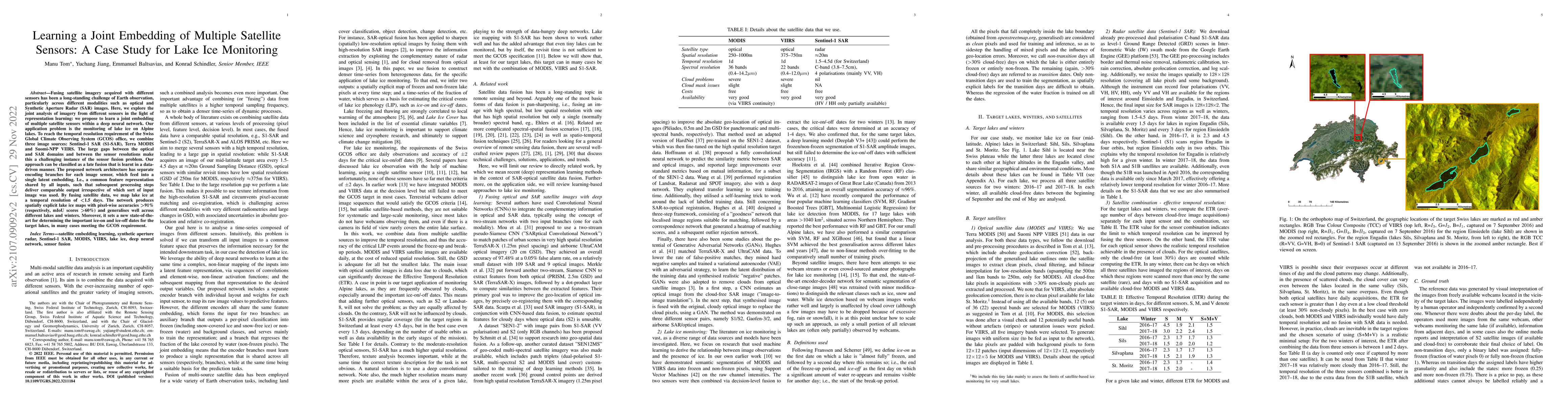
Fusing satellite imagery acquired with different sensors has been a long-standing challenge of Earth observation, particularly across different modalities such as optical and Synthetic Aperture Rada...
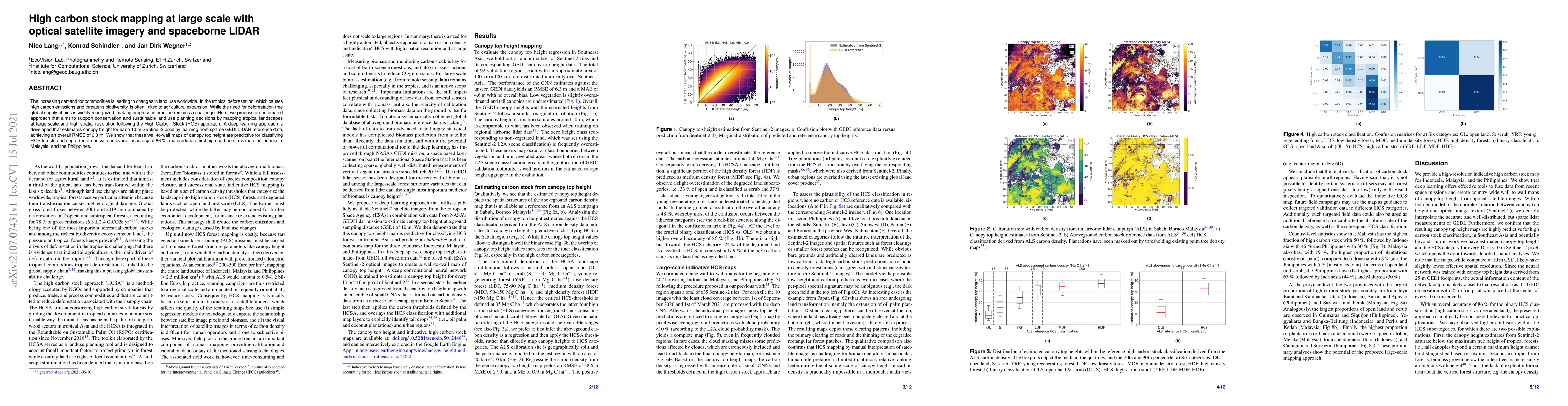
The increasing demand for commodities is leading to changes in land use worldwide. In the tropics, deforestation, which causes high carbon emissions and threatens biodiversity, is often linked to ag...
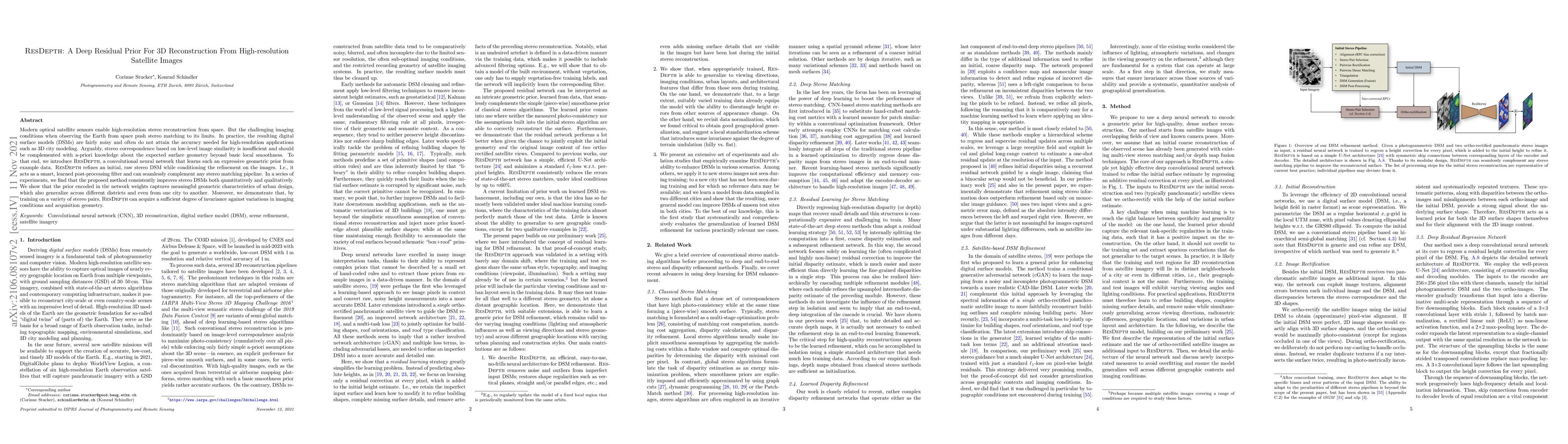
Modern optical satellite sensors enable high-resolution stereo reconstruction from space. But the challenging imaging conditions when observing the Earth from space push stereo matching to its limit...
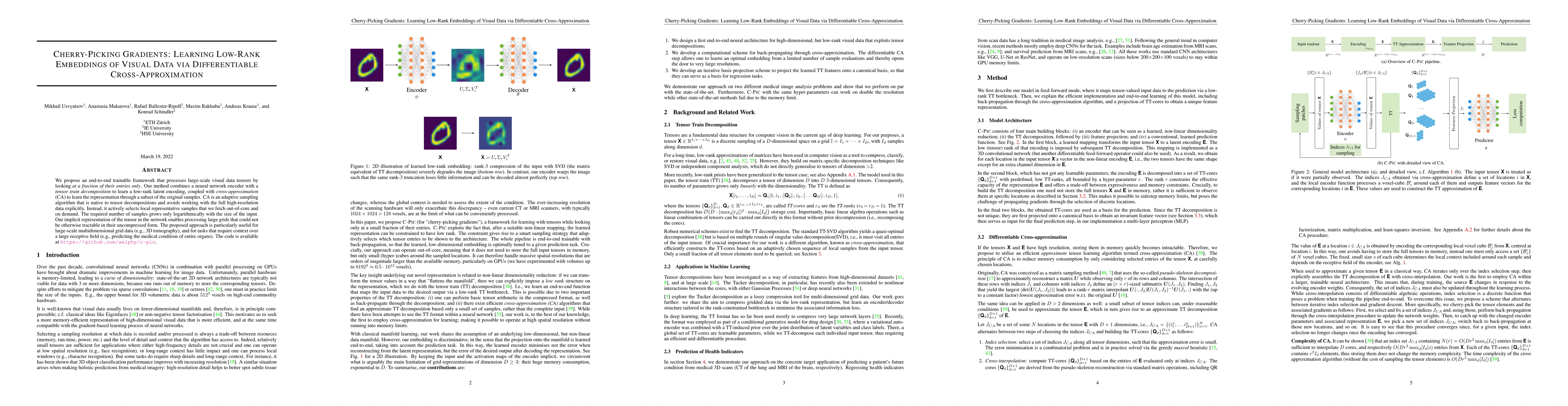
We propose an end-to-end trainable framework that processes large-scale visual data tensors by looking at a fraction of their entries only. Our method combines a neural network encoder with a tensor...
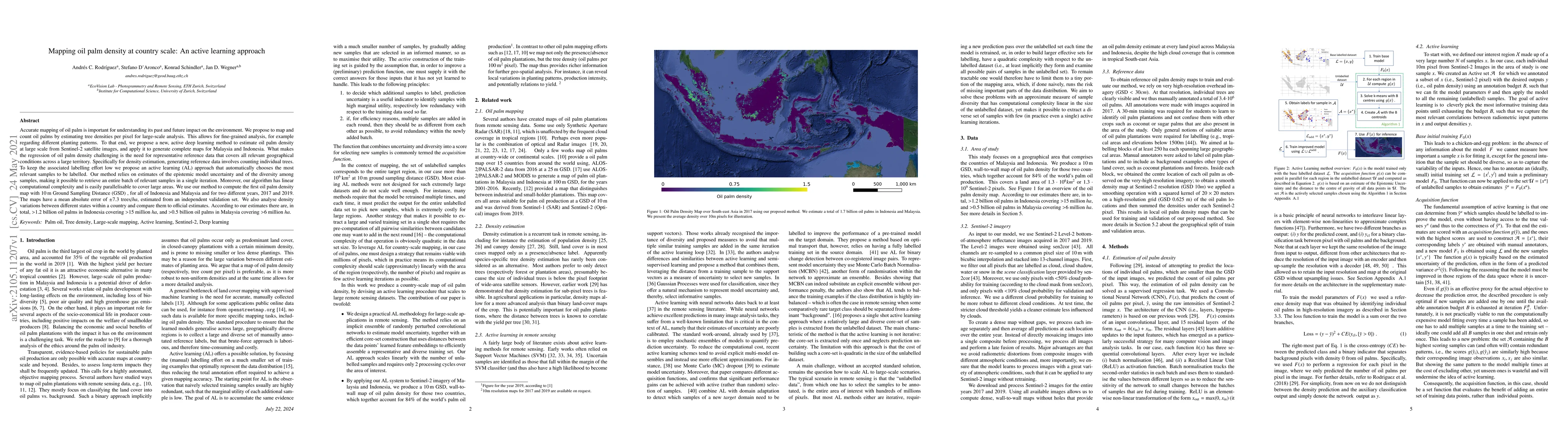
Accurate mapping of oil palm is important for understanding its past and future impact on the environment. We propose to map and count oil palms by estimating tree densities per pixel for large-scal...
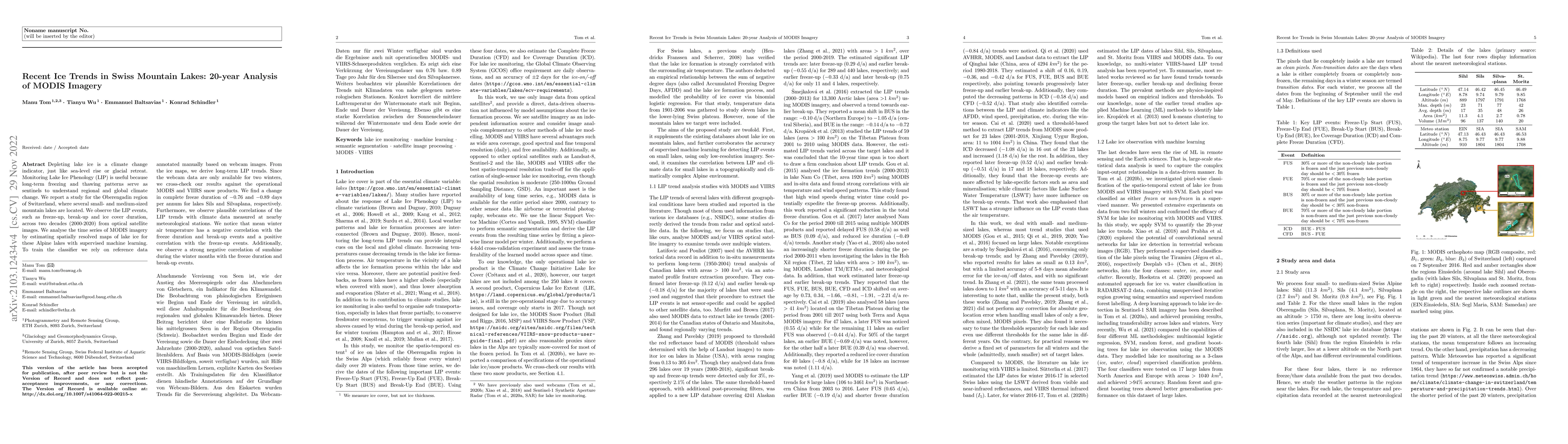
Depleting lake ice is a climate change indicator, just like sea-level rise or glacial retreat. Monitoring Lake Ice Phenology (LIP) is useful because long-term freezing and thawing patterns serve as ...
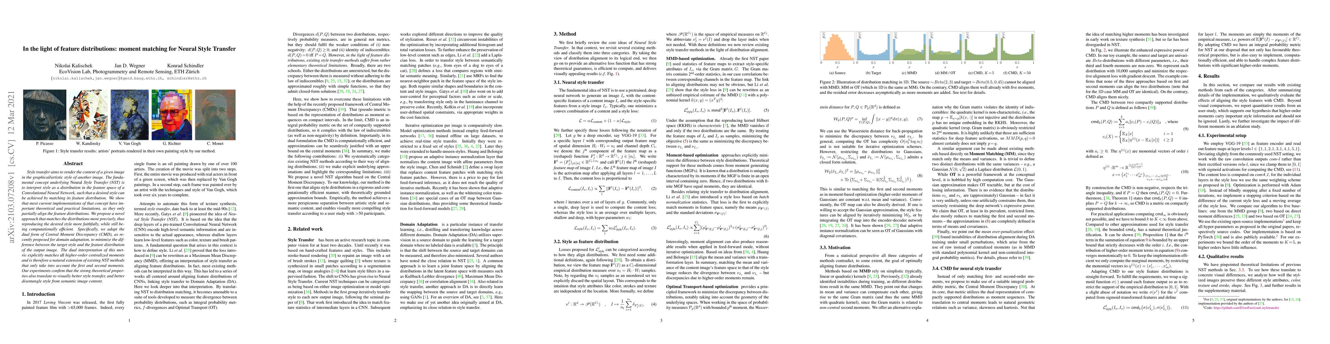
Style transfer aims to render the content of a given image in the graphical/artistic style of another image. The fundamental concept underlying NeuralStyle Transfer (NST) is to interpret style as a ...
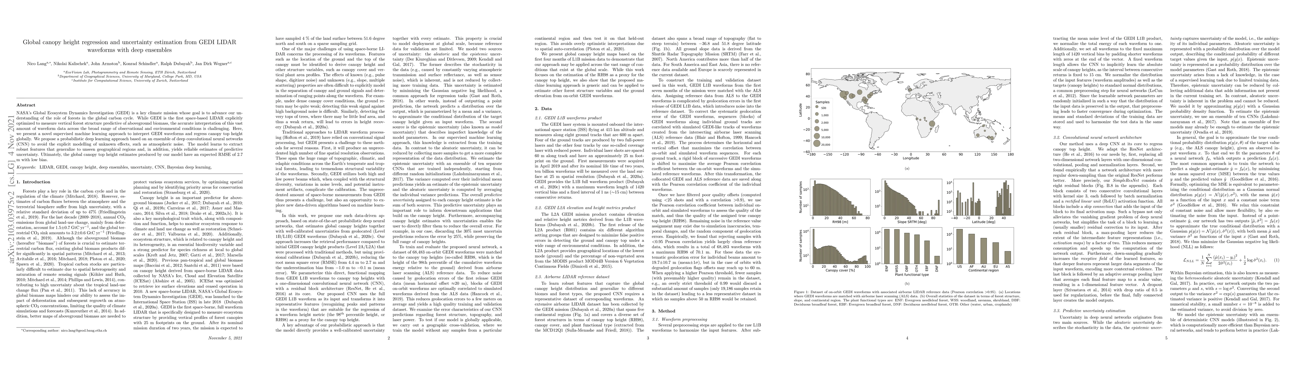
NASA's Global Ecosystem Dynamics Investigation (GEDI) is a key climate mission whose goal is to advance our understanding of the role of forests in the global carbon cycle. While GEDI is the first s...
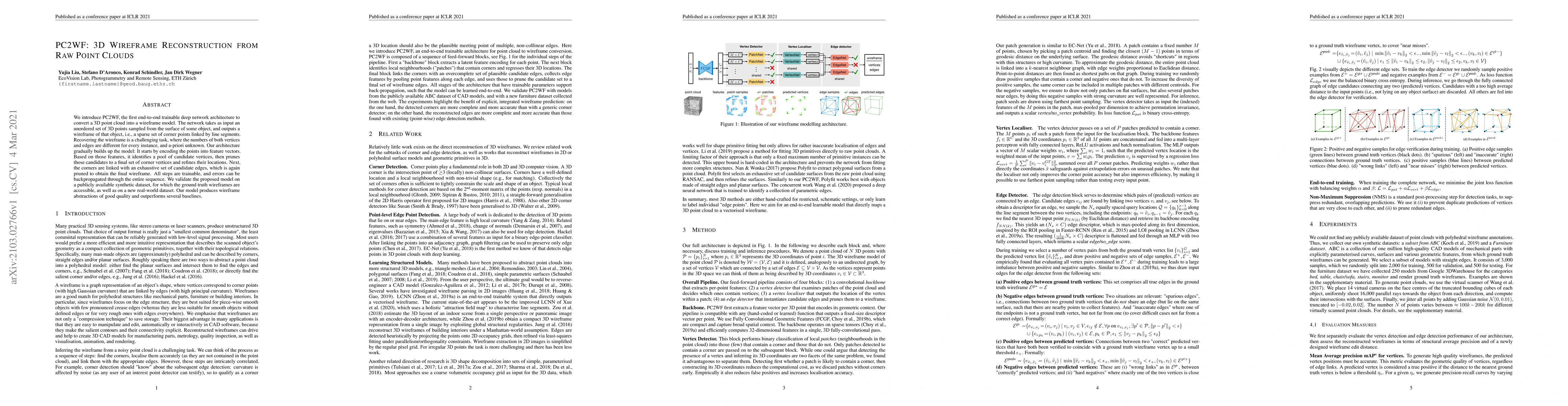
We introduce PC2WF, the first end-to-end trainable deep network architecture to convert a 3D point cloud into a wireframe model. The network takes as input an unordered set of 3D points sampled from...
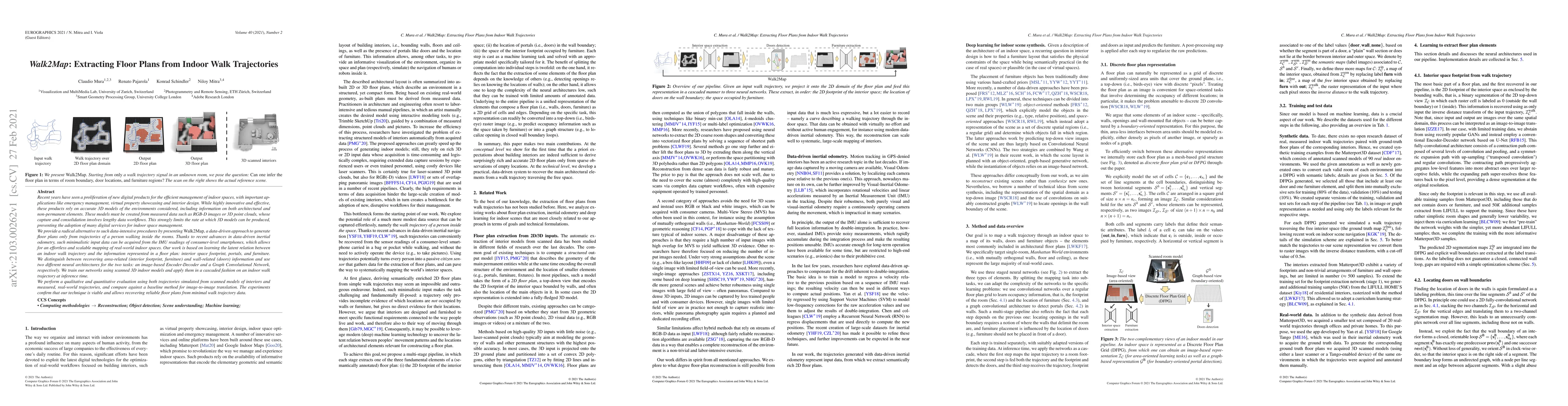
Recent years have seen a proliferation of new digital products for the efficient management of indoor spaces, with important applications like emergency management, virtual property showcasing and i...
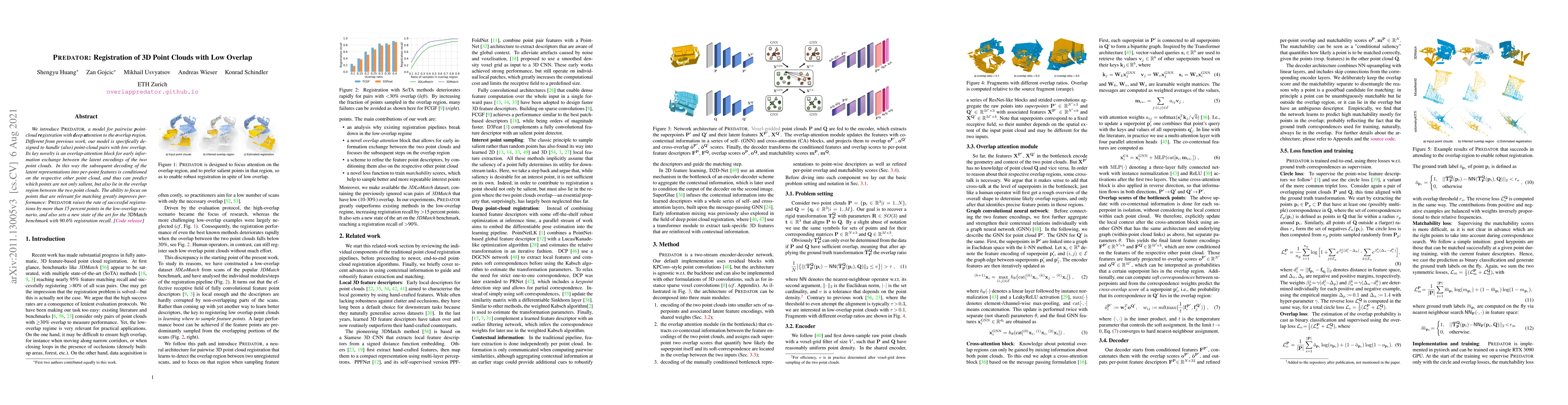
We introduce PREDATOR, a model for pairwise point-cloud registration with deep attention to the overlap region. Different from previous work, our model is specifically designed to handle (also) poin...
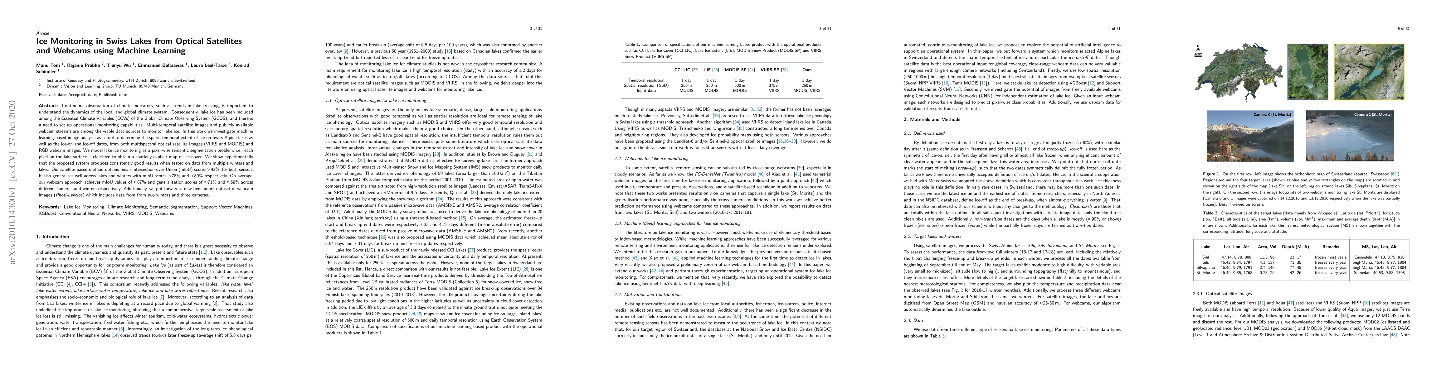
Continuous observation of climate indicators, such as trends in lake freezing, is important to understand the dynamics of the local and global climate system. Consequently, lake ice has been include...
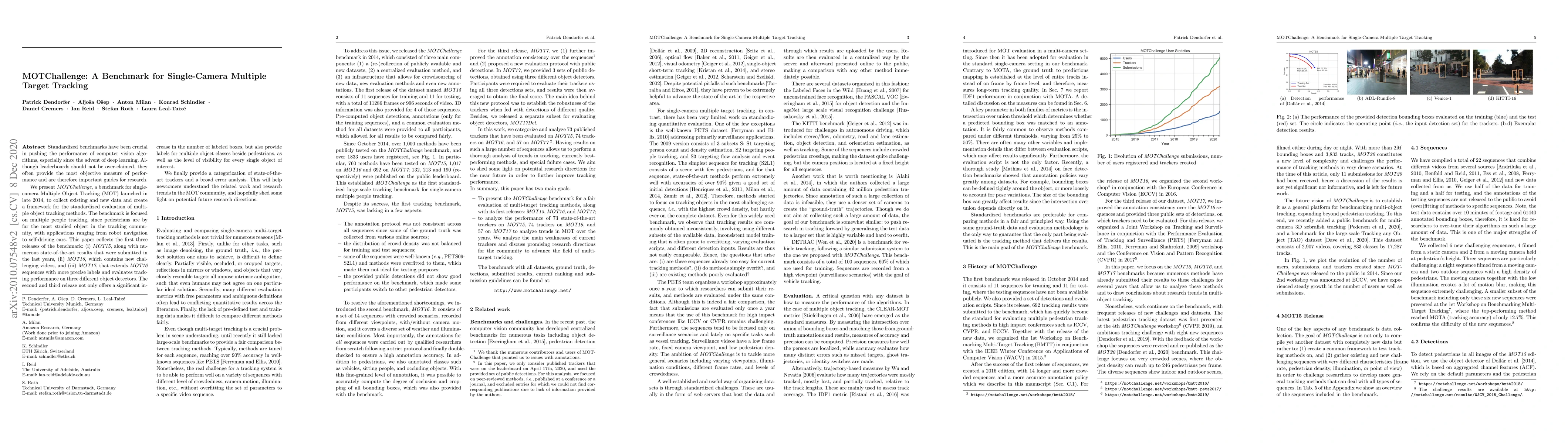
Standardized benchmarks have been crucial in pushing the performance of computer vision algorithms, especially since the advent of deep learning. Although leaderboards should not be over-claimed, th...
We investigate active learning in the context of deep neural network models for change detection and map updating. Active learning is a natural choice for a number of remote sensing tasks, including...
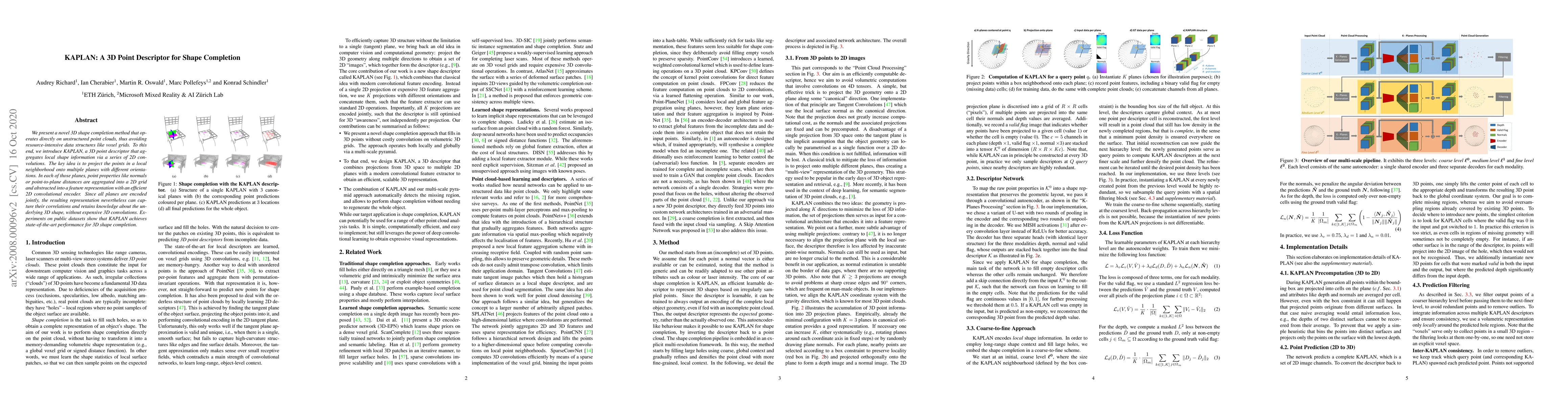
We present a novel 3D shape completion method that operates directly on unstructured point clouds, thus avoiding resource-intensive data structures like voxel grids. To this end, we introduce KAPLAN...
Most consumer cameras are equipped with electronic rolling shutter, leading to image distortions when the camera moves during image capture. We explore a surprisingly simple camera configuration tha...
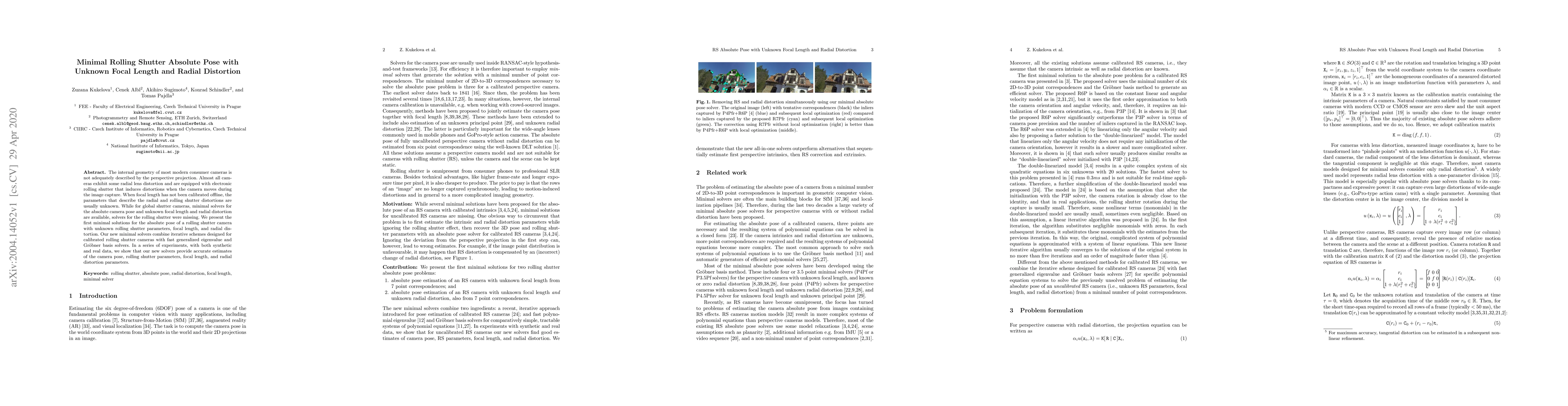
The internal geometry of most modern consumer cameras is not adequately described by the perspective projection. Almost all cameras exhibit some radial lens distortion and are equipped with an elect...
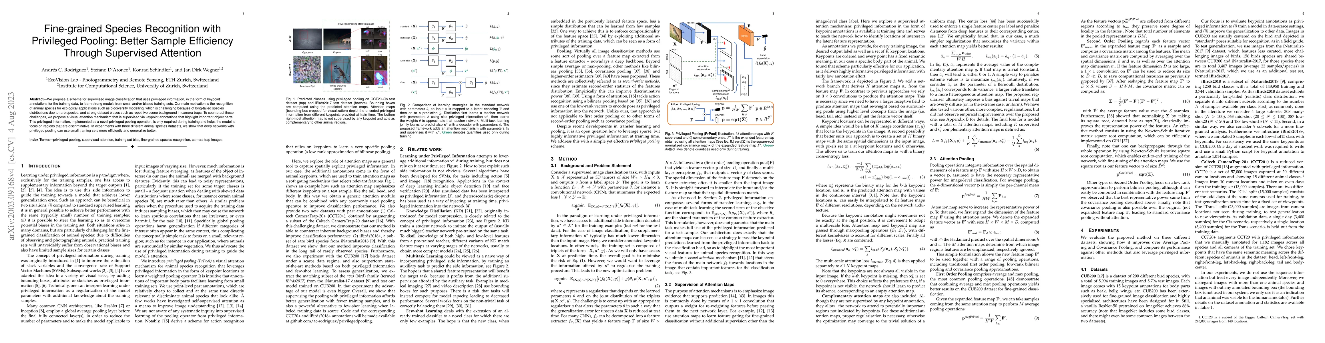
We propose a scheme for supervised image classification that uses privileged information, in the form of keypoint annotations for the training data, to learn strong models from small and/or biased t...
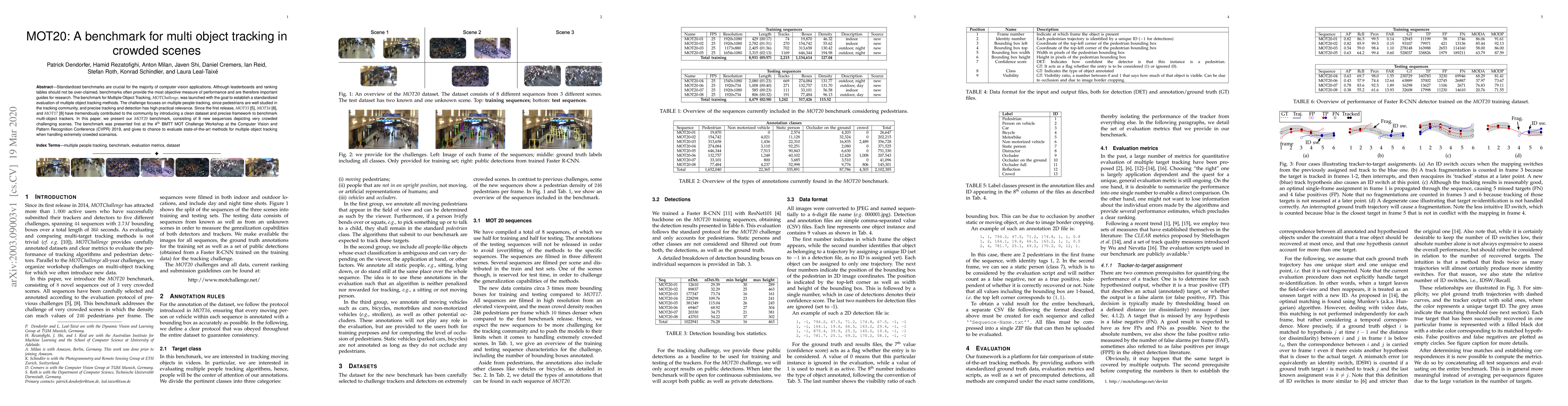
Standardized benchmarks are crucial for the majority of computer vision applications. Although leaderboards and ranking tables should not be over-claimed, benchmarks often provide the most objective...
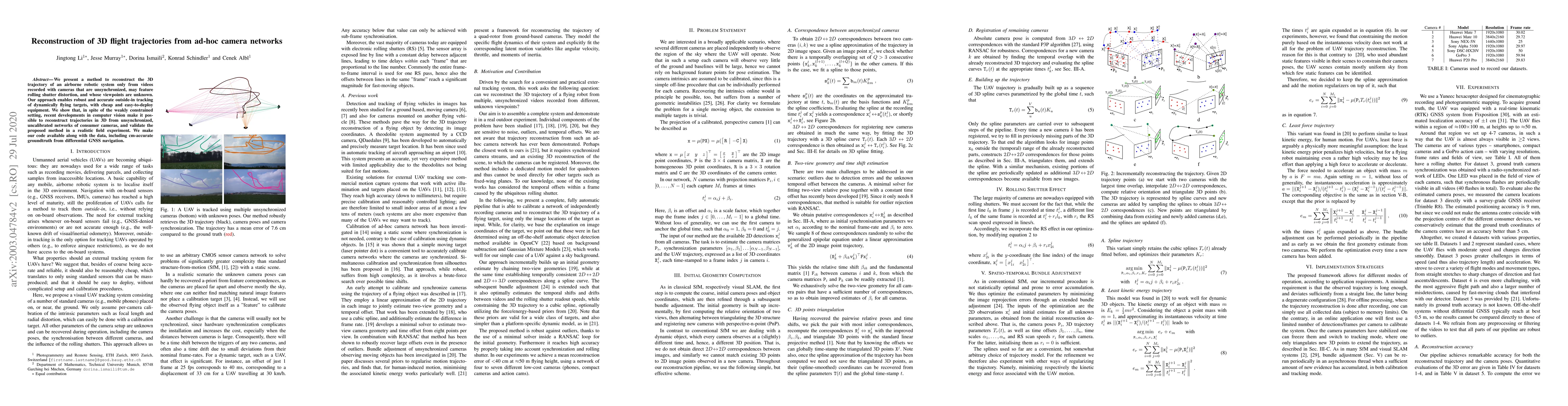
We present a method to reconstruct the 3D trajectory of an airborne robotic system only from videos recorded with cameras that are unsynchronized, may feature rolling shutter distortion, and whose v...
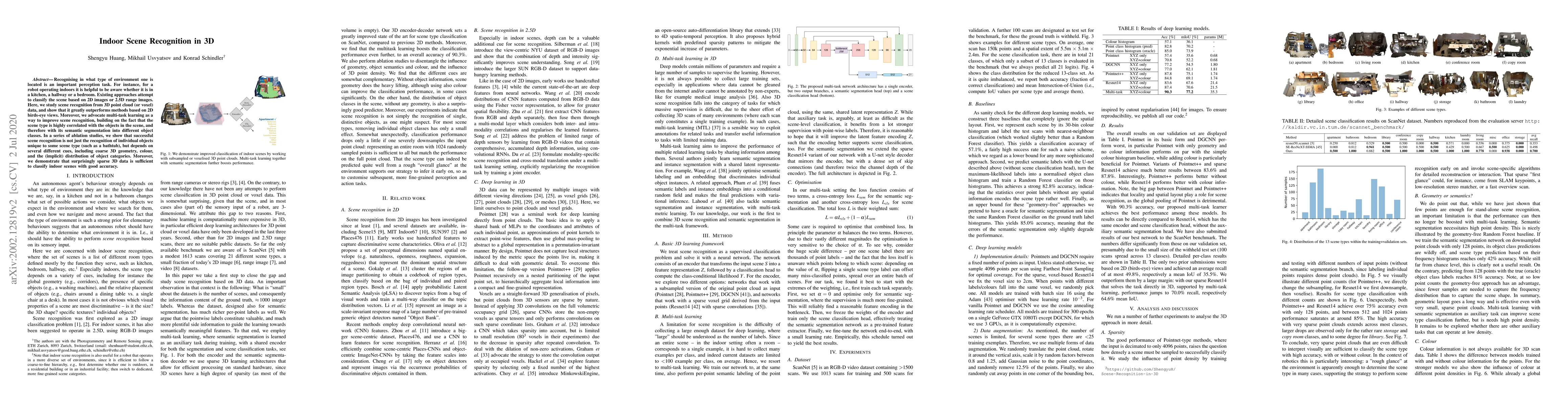
Recognising in what type of environment one is located is an important perception task. For instance, for a robot operating in indoors it is helpful to be aware whether it is in a kitchen, a hallway...
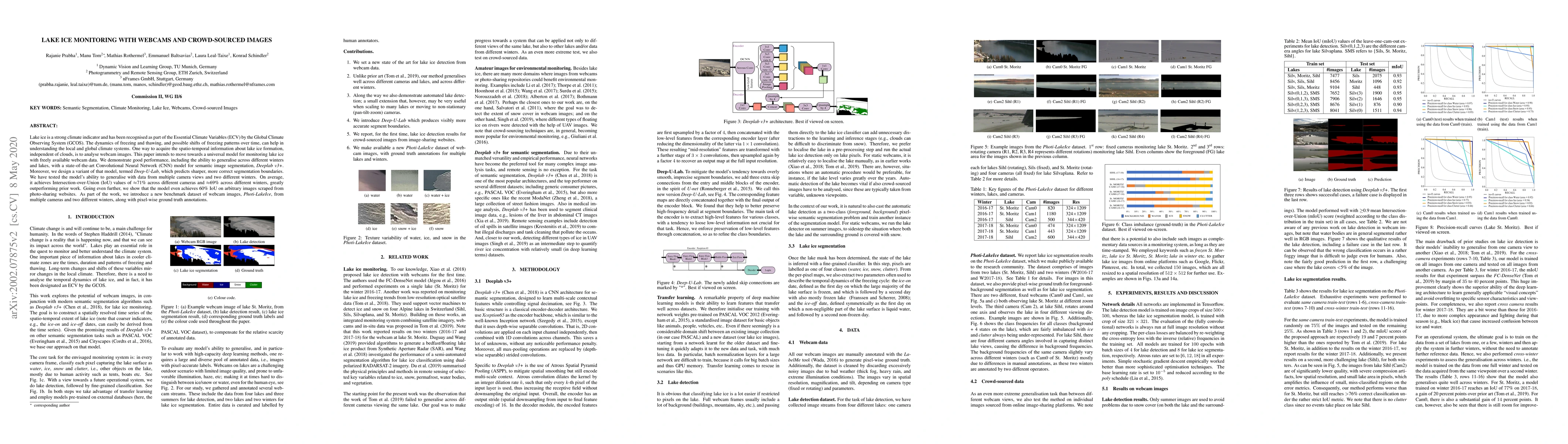
Lake ice is a strong climate indicator and has been recognised as part of the Essential Climate Variables (ECV) by the Global Climate Observing System (GCOS). The dynamics of freezing and thawing, a...
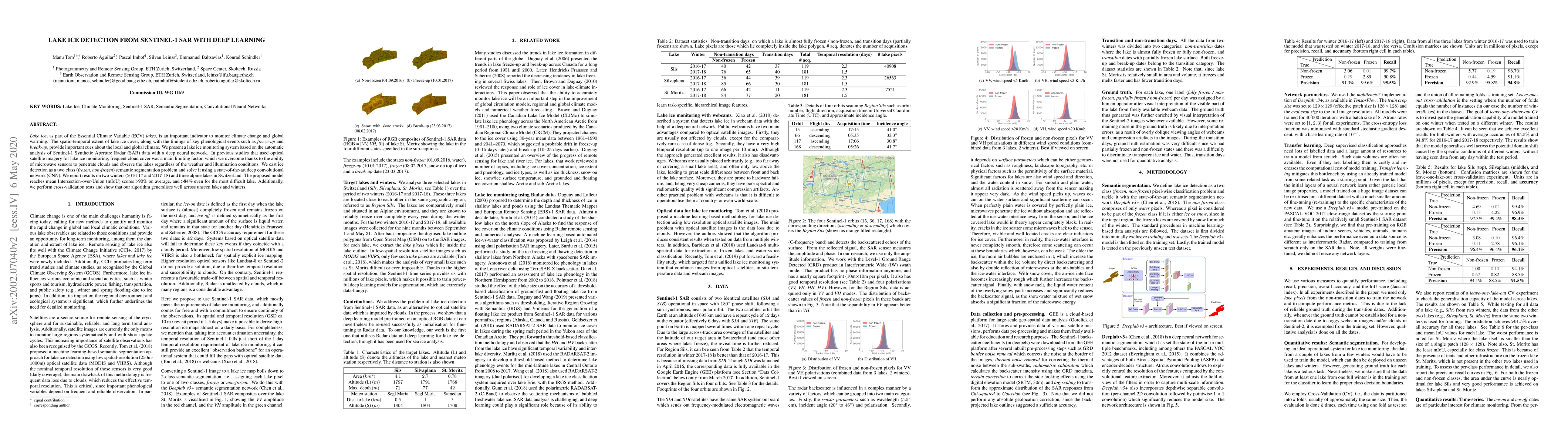
Lake ice, as part of the Essential Climate Variable (ECV) lakes, is an important indicator to monitor climate change and global warming. The spatio-temporal extent of lake ice cover, along with the ...
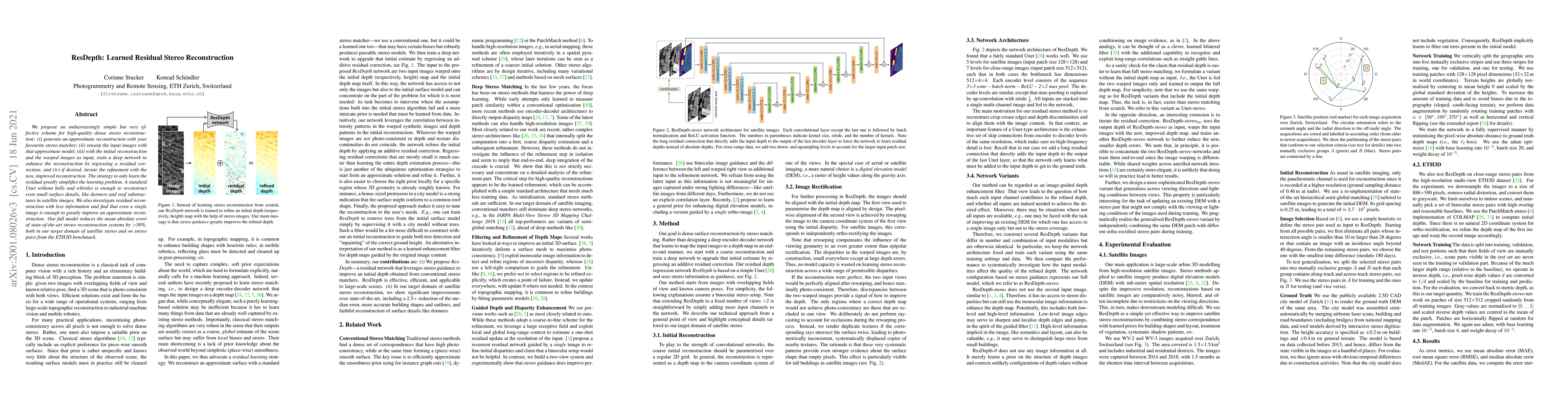
We propose an embarrassingly simple but very effective scheme for high-quality dense stereo reconstruction: (i) generate an approximate reconstruction with your favourite stereo matcher; (ii) rewarp...
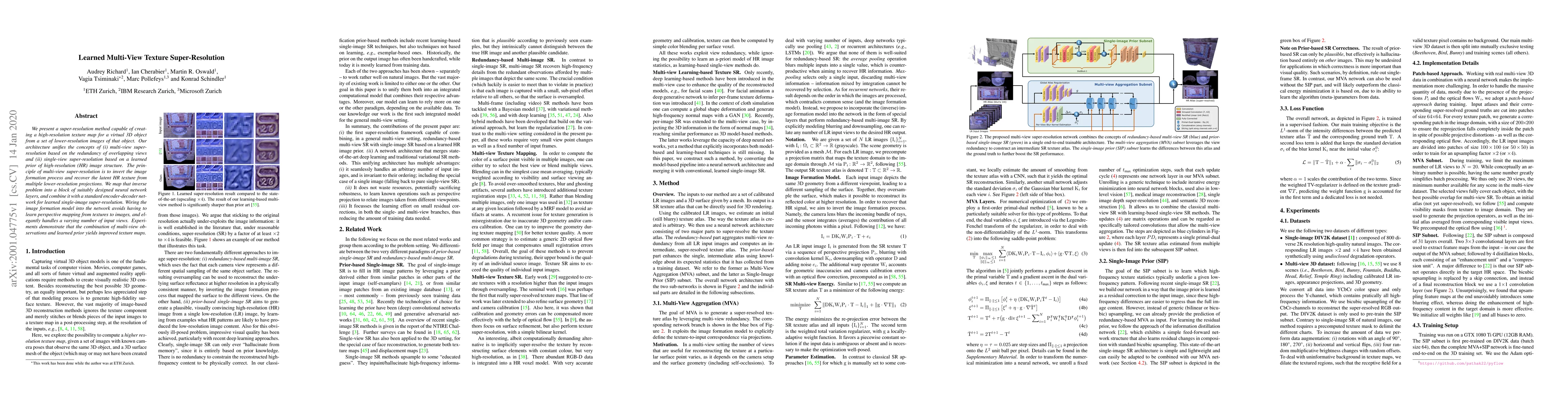
We present a super-resolution method capable of creating a high-resolution texture map for a virtual 3D object from a set of lower-resolution images of that object. Our architecture unifies the conc...
The goal of many computer vision systems is to transform image pixels into 3D representations. Recent popular models use neural networks to regress directly from pixels to 3D object parameters. Such...
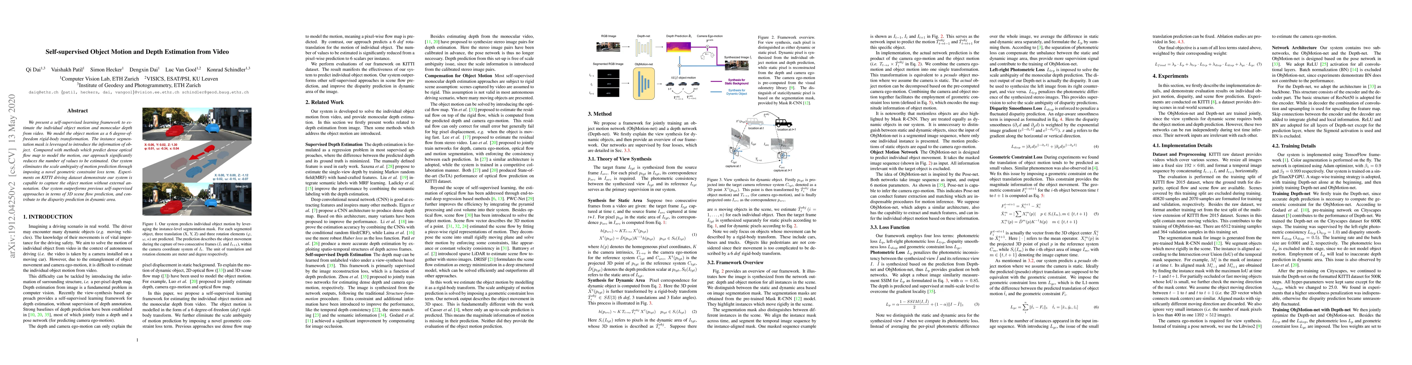
We present a self-supervised learning framework to estimate the individual object motion and monocular depth from video. We model the object motion as a 6 degree-of-freedom rigid-body transformation...
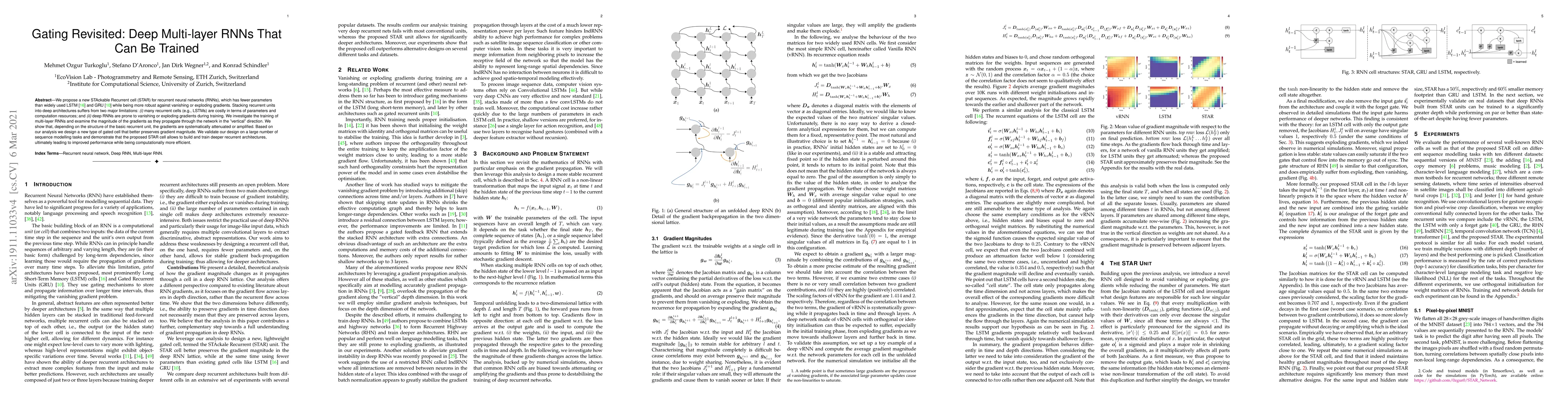
We propose a new STAckable Recurrent cell (STAR) for recurrent neural networks (RNNs), which has fewer parameters than widely used LSTM and GRU while being more robust against vanishing or exploding...
Up-to-date catalogs of the urban tree population are important for municipalities to monitor and improve quality of life in cities. Despite much research on automation of tree mapping, mainly relyin...
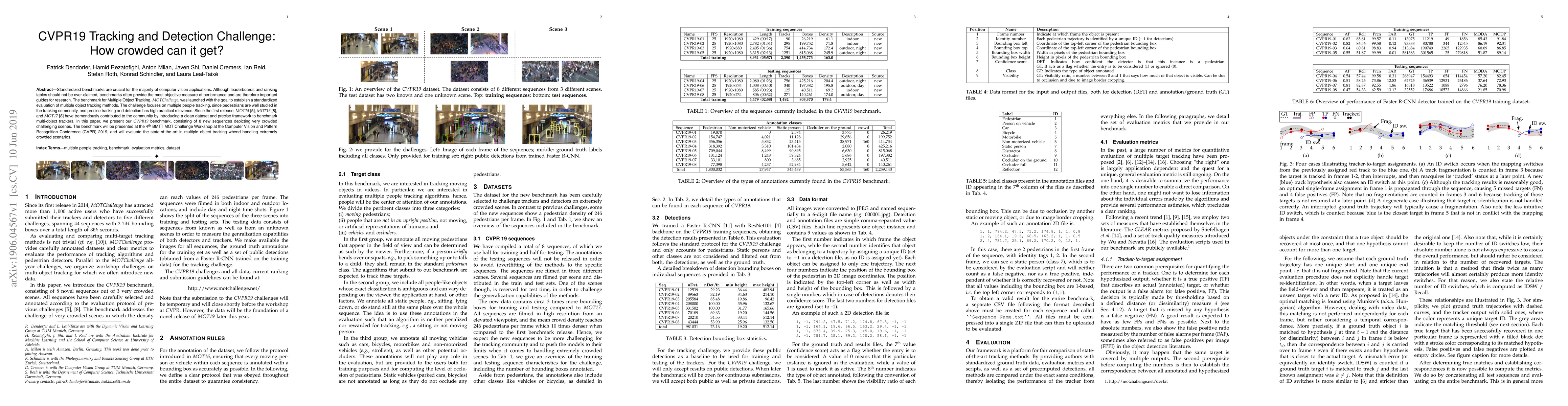
Standardized benchmarks are crucial for the majority of computer vision applications. Although leaderboards and ranking tables should not be over-claimed, benchmarks often provide the most objective...
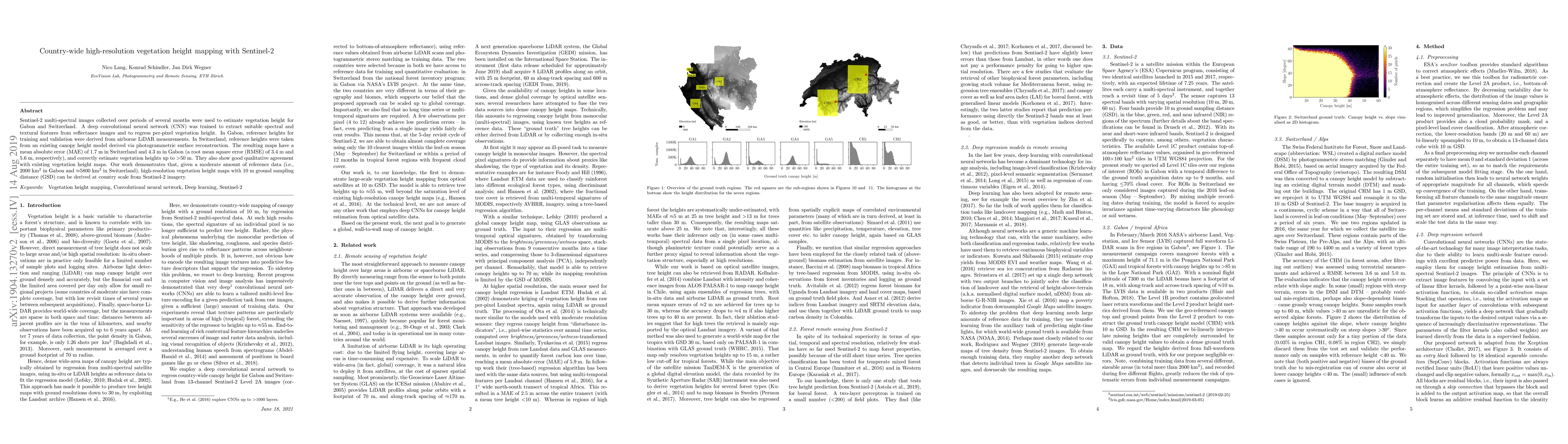
Sentinel-2 multi-spectral images collected over periods of several months were used to estimate vegetation height for Gabon and Switzerland. A deep convolutional neural network (CNN) was trained to ...
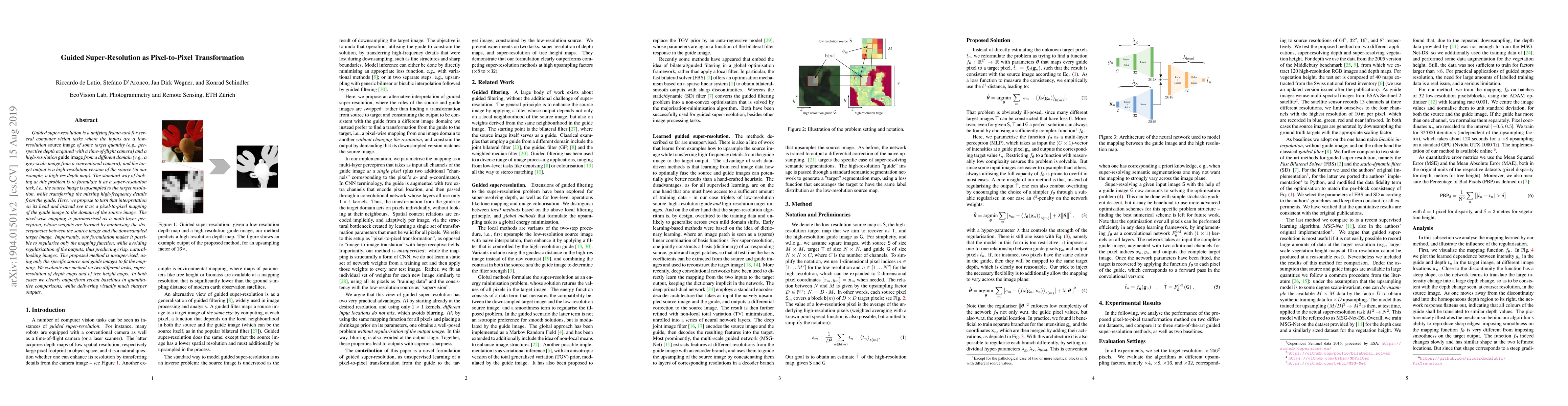
Guided super-resolution is a unifying framework for several computer vision tasks where the inputs are a low-resolution source image of some target quantity (e.g., perspective depth acquired with a ...
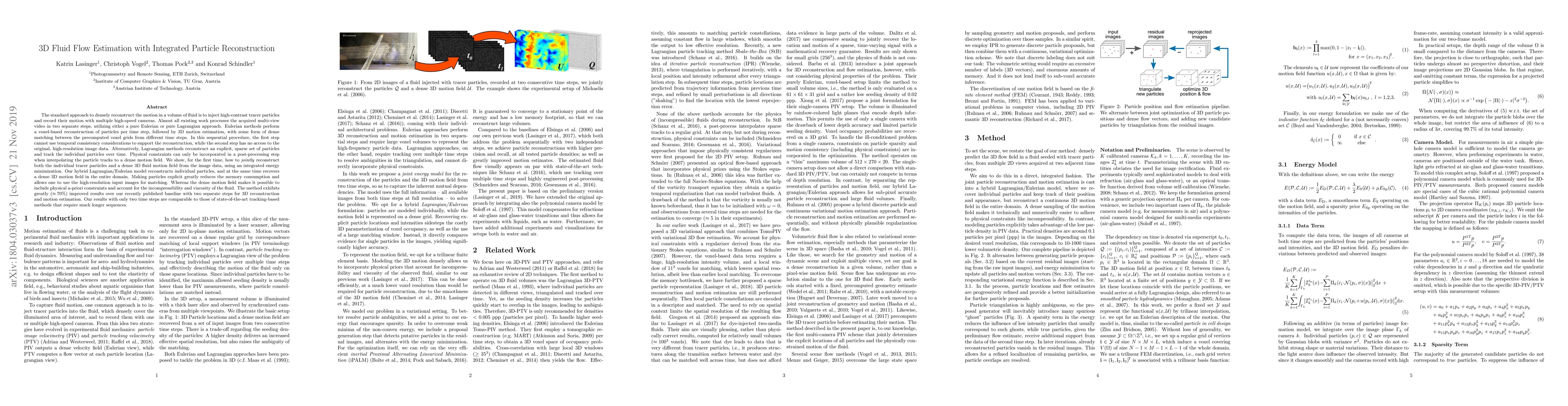
The standard approach to densely reconstruct the motion in a volume of fluid is to inject high-contrast tracer particles and record their motion with multiple high-speed cameras. Almost all existing...
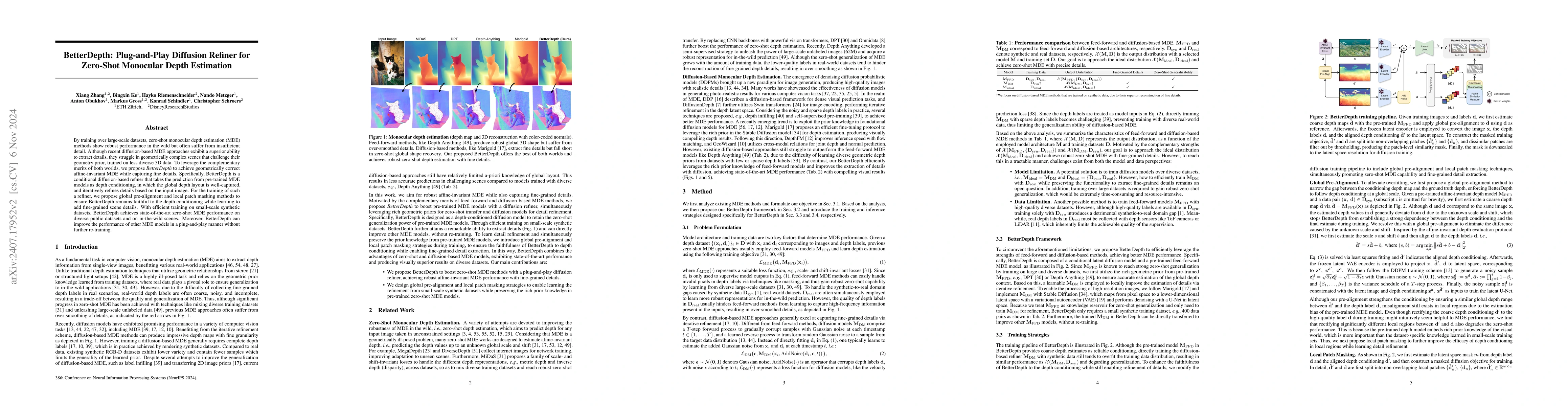
By training over large-scale datasets, zero-shot monocular depth estimation (MDE) methods show robust performance in the wild but often suffer from insufficiently precise details. Although recent diff...
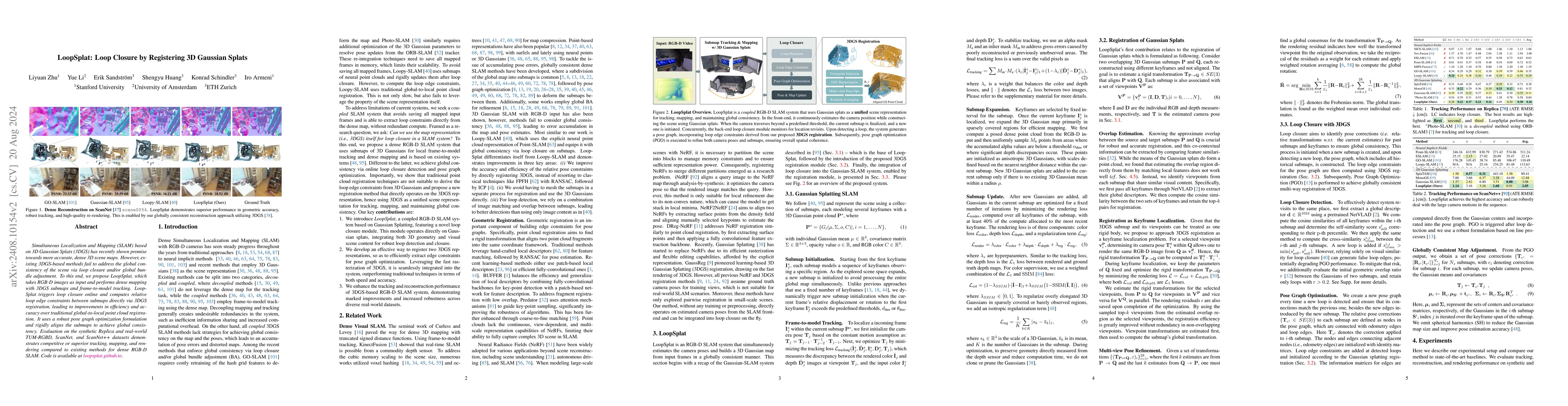
Simultaneous Localization and Mapping (SLAM) based on 3D Gaussian Splats (3DGS) has recently shown promise towards more accurate, dense 3D scene maps. However, existing 3DGS-based methods fail to addr...
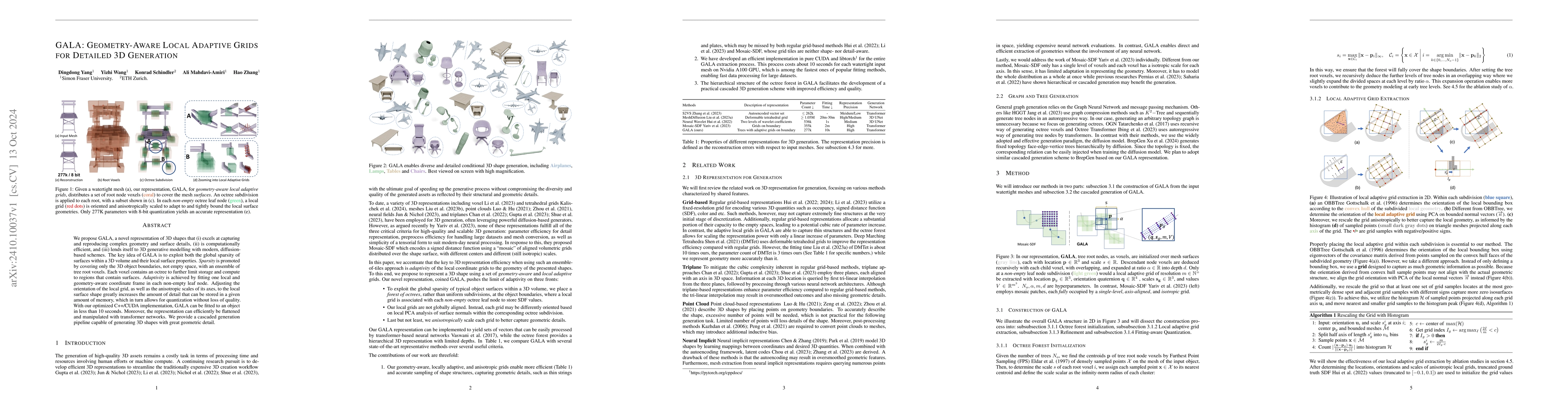
We propose GALA, a novel representation of 3D shapes that (i) excels at capturing and reproducing complex geometry and surface details, (ii) is computationally efficient, and (iii) lends itself to 3D ...
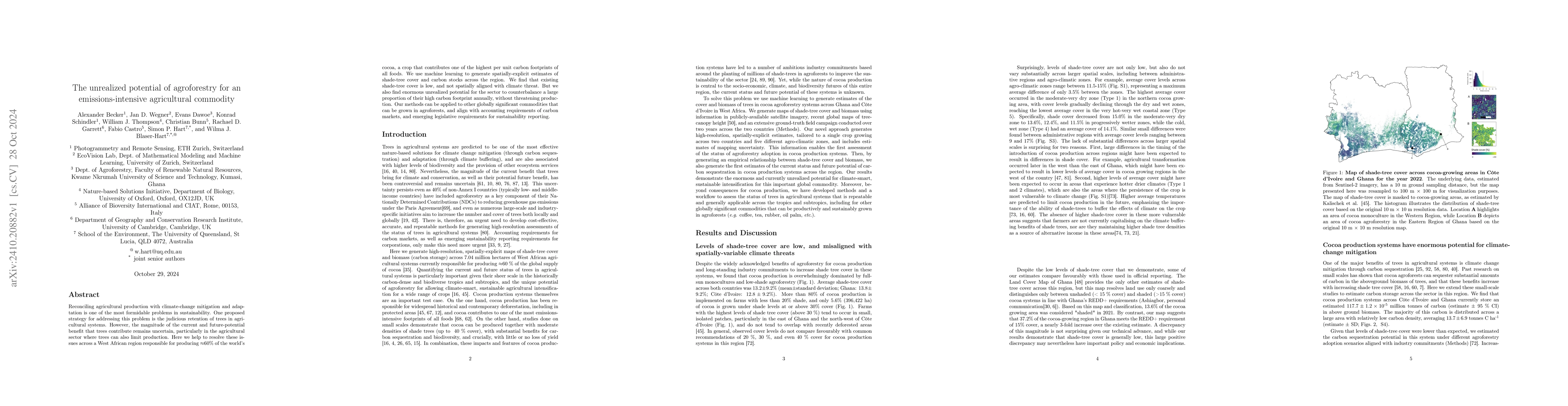
Reconciling agricultural production with climate-change mitigation and adaptation is one of the most formidable problems in sustainability. One proposed strategy for addressing this problem is the jud...
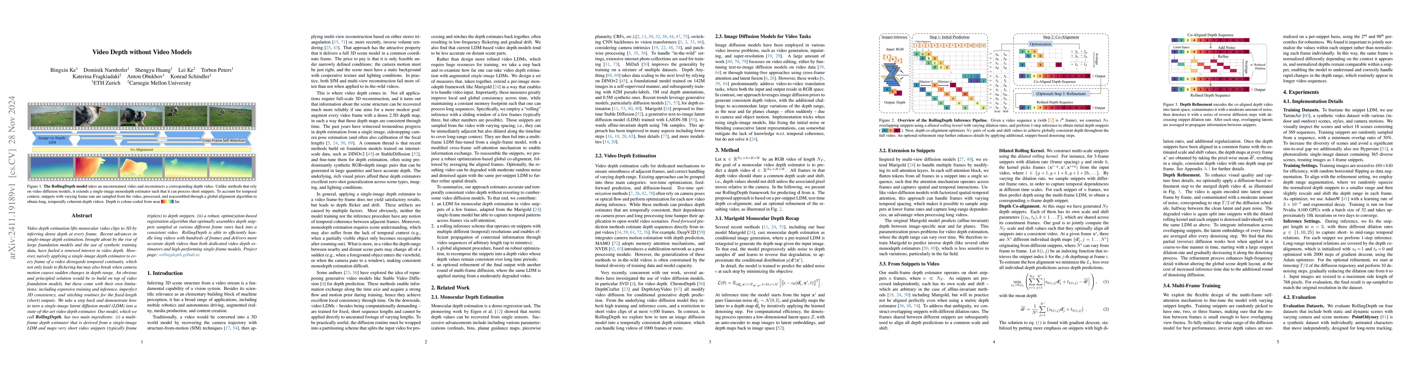
Video depth estimation lifts monocular video clips to 3D by inferring dense depth at every frame. Recent advances in single-image depth estimation, brought about by the rise of large foundation models...
Accurate uncertainty information associated with essential climate variables (ECVs) is crucial for reliable climate modeling and understanding the spatiotemporal evolution of the Earth system. In rece...
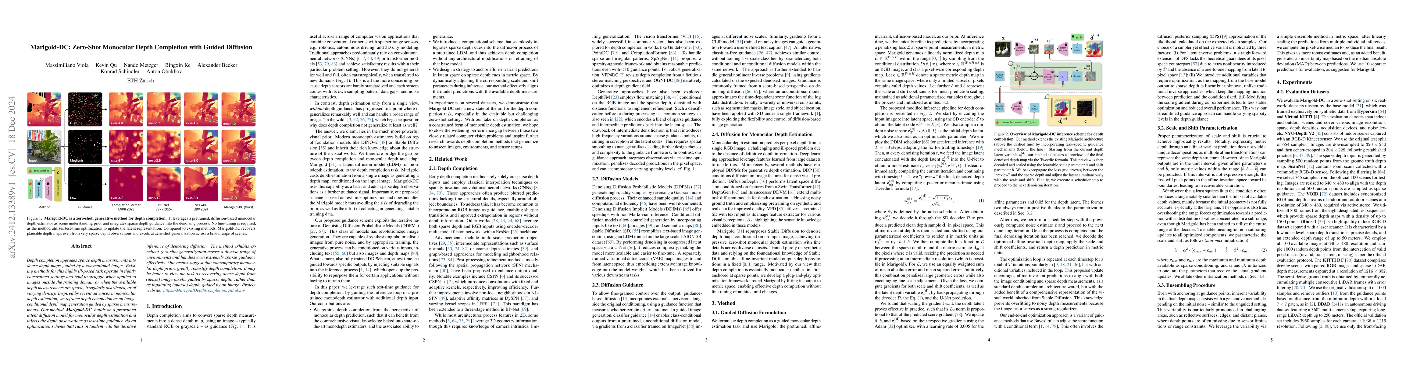
Depth completion upgrades sparse depth measurements into dense depth maps guided by a conventional image. Existing methods for this highly ill-posed task operate in tightly constrained settings and te...
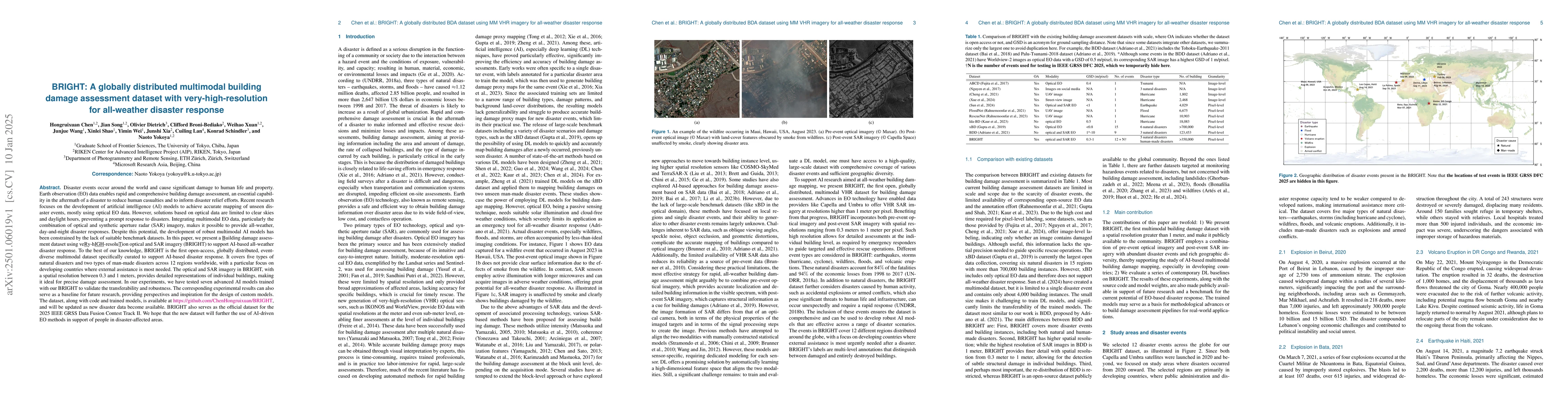
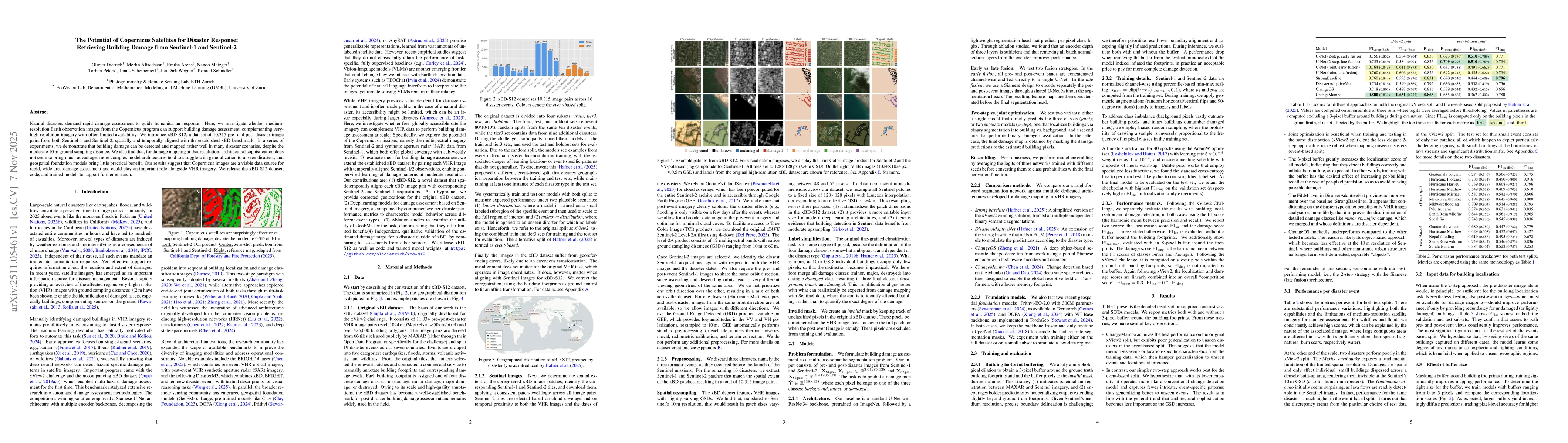
Disaster events occur around the world and cause significant damage to human life and property. Earth observation (EO) data enables rapid and comprehensive building damage assessment (BDA), an essenti...
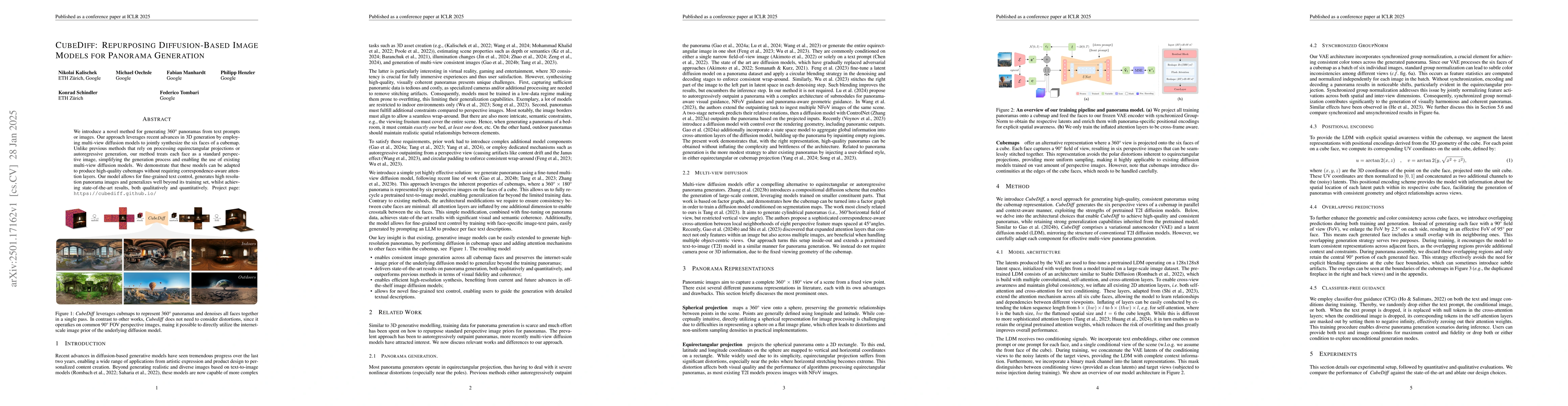
We introduce a novel method for generating 360{\deg} panoramas from text prompts or images. Our approach leverages recent advances in 3D generation by employing multi-view diffusion models to jointly ...
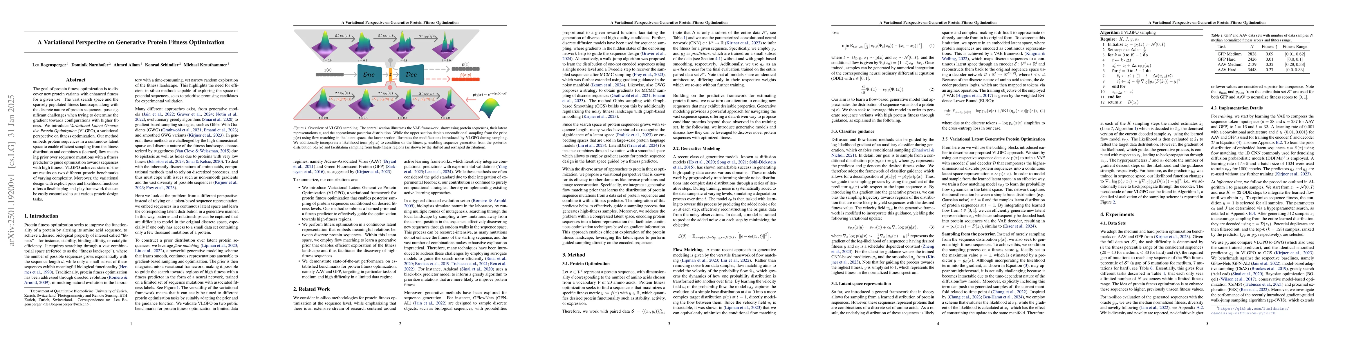
The goal of protein fitness optimization is to discover new protein variants with enhanced fitness for a given use. The vast search space and the sparsely populated fitness landscape, along with the d...
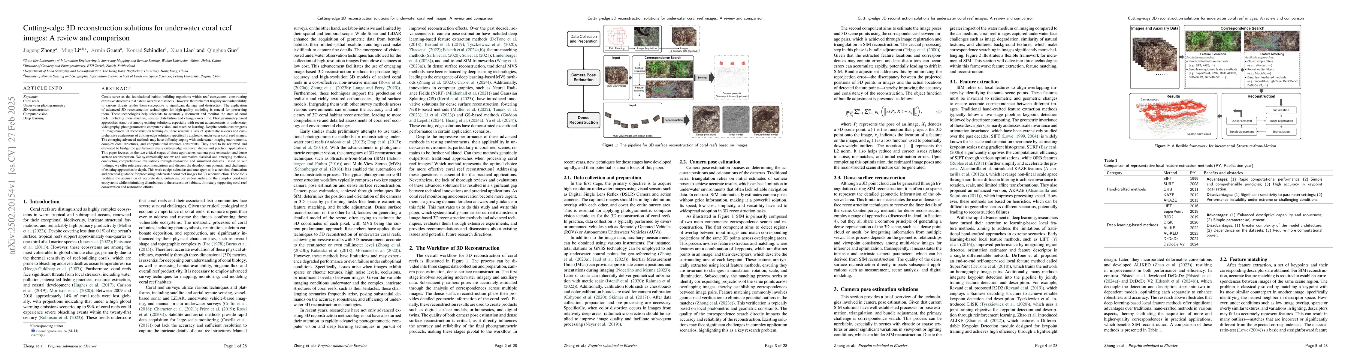
Corals serve as the foundational habitat-building organisms within reef ecosystems, constructing extensive structures that extend over vast distances. However, their inherent fragility and vulnerabili...
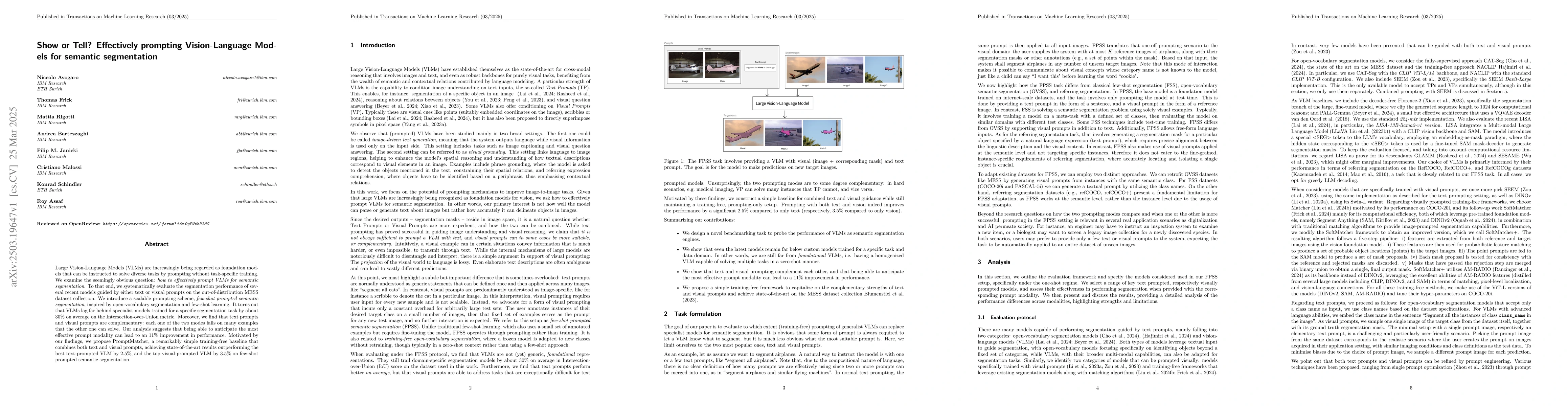
Large Vision-Language Models (VLMs) are increasingly being regarded as foundation models that can be instructed to solve diverse tasks by prompting, without task-specific training. We examine the seem...
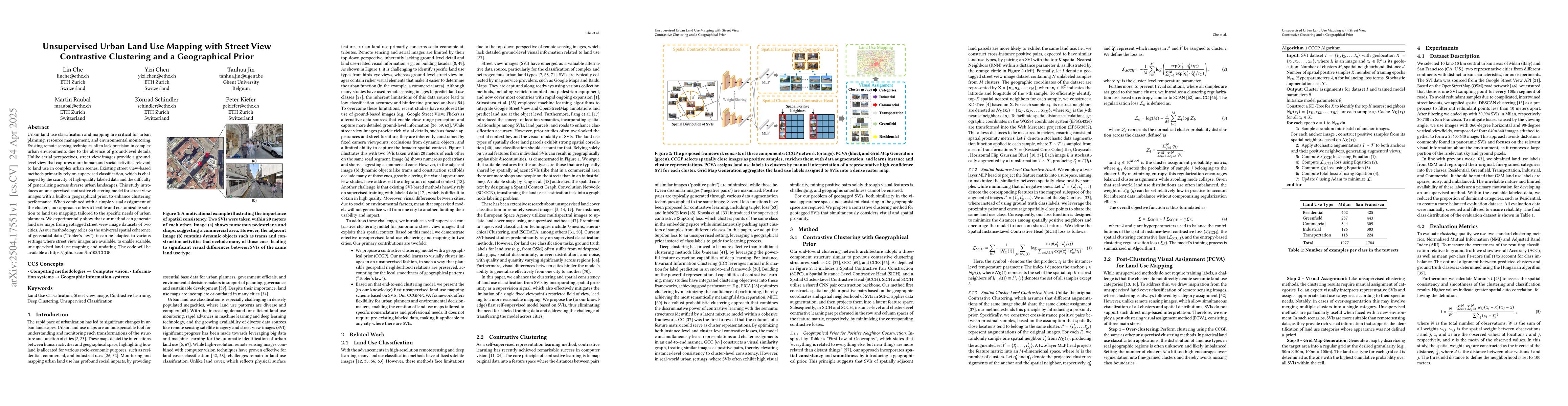
Urban land use classification and mapping are critical for urban planning, resource management, and environmental monitoring. Existing remote sensing techniques often lack precision in complex urban e...
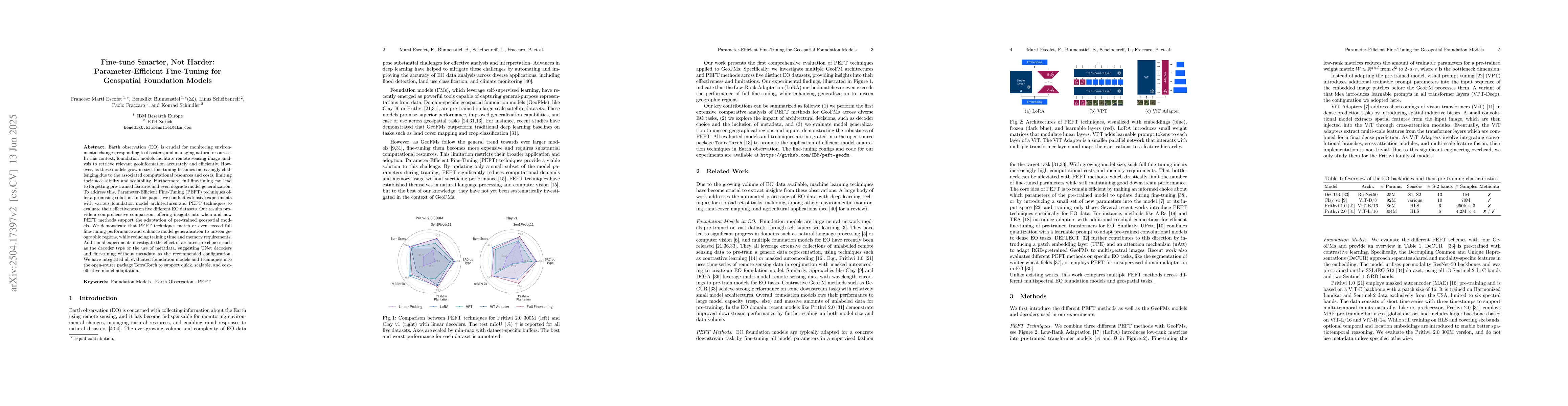
Earth observation (EO) is crucial for monitoring environmental changes, responding to disasters, and managing natural resources. In this context, foundation models facilitate remote sensing image anal...
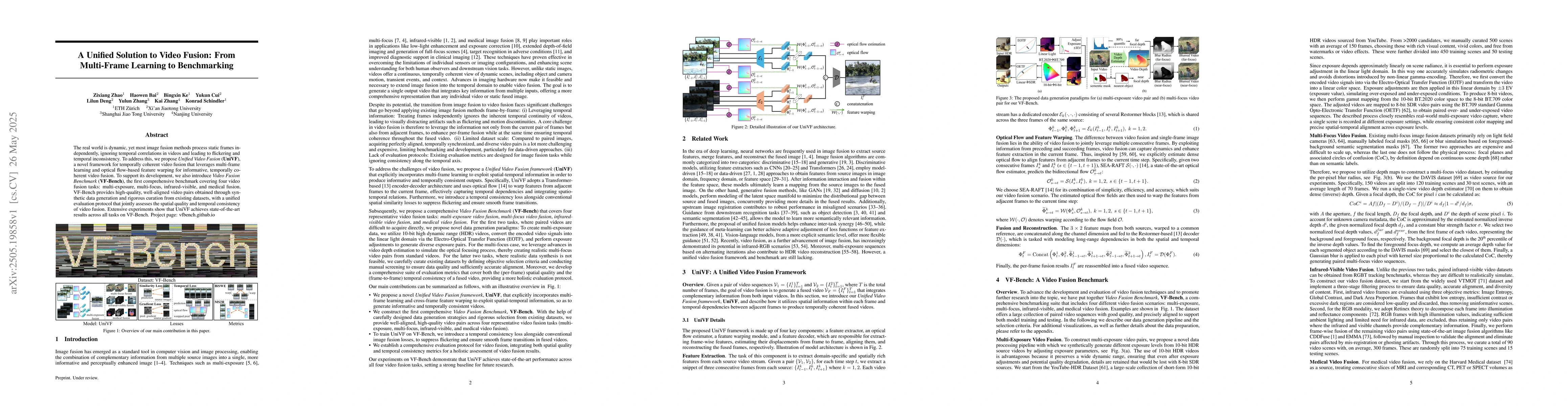
The real world is dynamic, yet most image fusion methods process static frames independently, ignoring temporal correlations in videos and leading to flickering and temporal inconsistency. To address ...
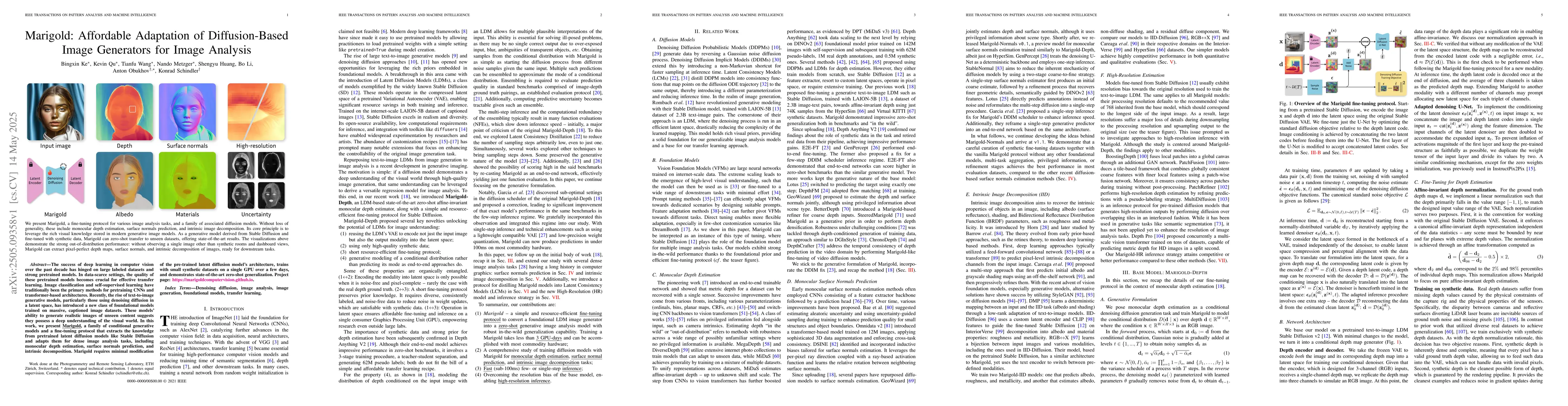
The success of deep learning in computer vision over the past decade has hinged on large labeled datasets and strong pretrained models. In data-scarce settings, the quality of these pretrained models ...
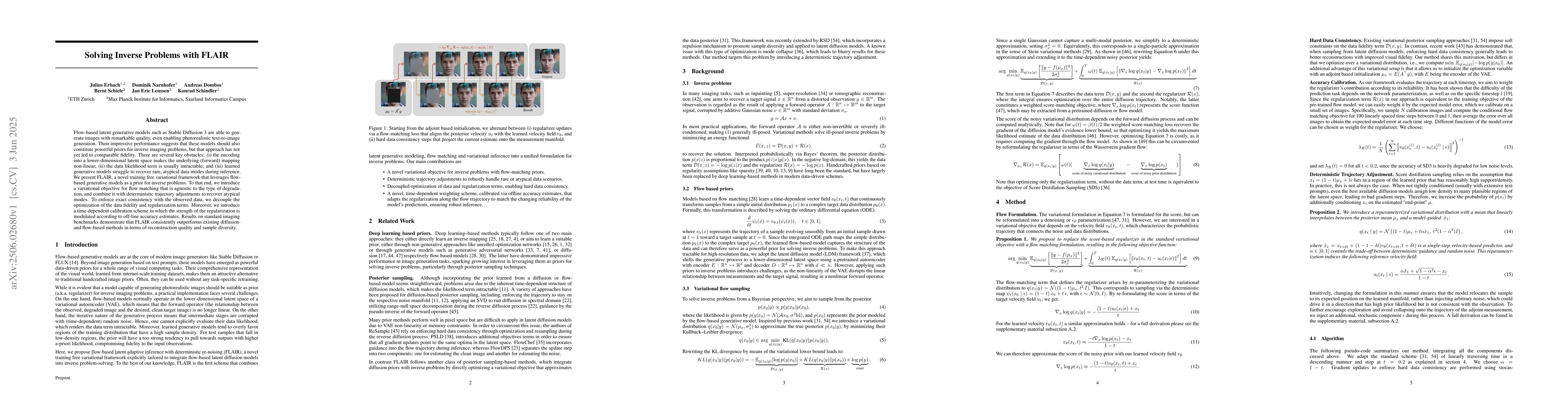
Flow-based latent generative models such as Stable Diffusion 3 are able to generate images with remarkable quality, even enabling photorealistic text-to-image generation. Their impressive performance ...
Super-resolution aims to increase the resolution of satellite images by reconstructing high-frequency details, which go beyond na\"ive upsampling. This has particular relevance for Earth observation m...
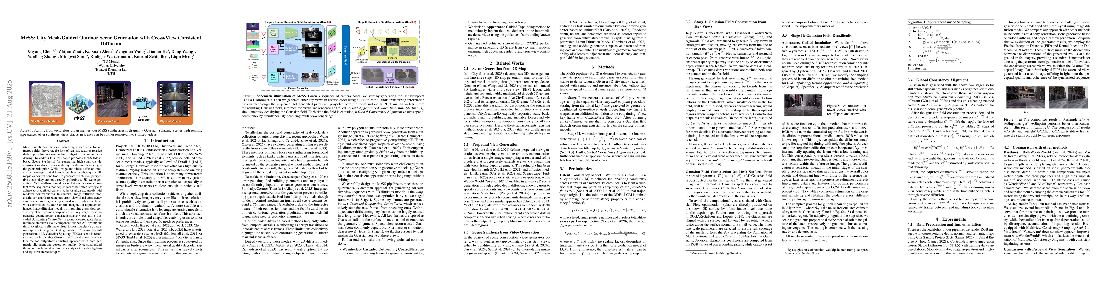
Mesh models have become increasingly accessible for numerous cities; however, the lack of realistic textures restricts their application in virtual urban navigation and autonomous driving. To address ...
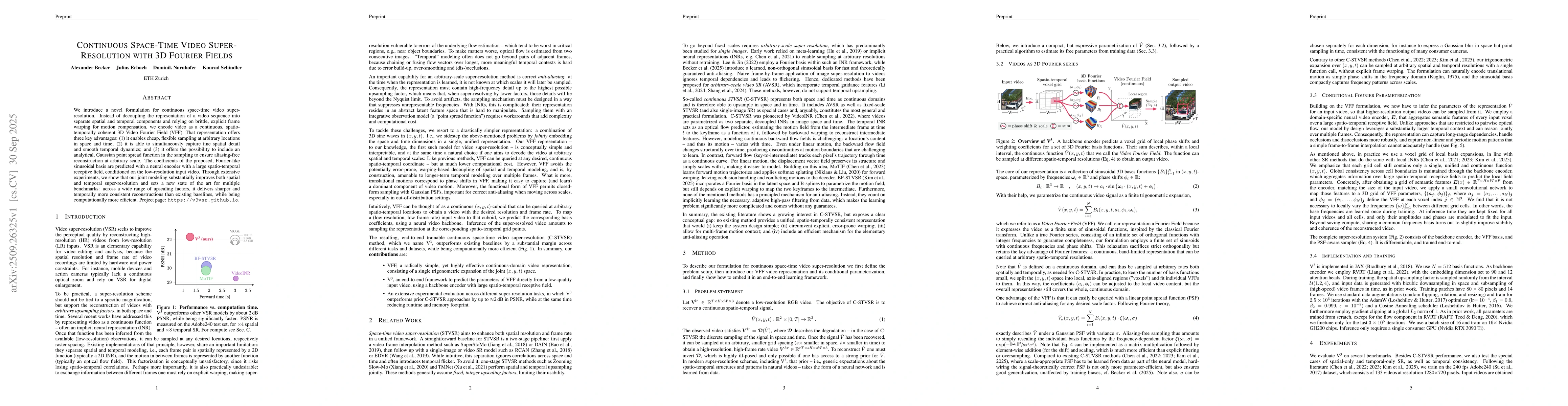
We introduce a novel formulation for continuous space-time video super-resolution. Instead of decoupling the representation of a video sequence into separate spatial and temporal components and relyin...
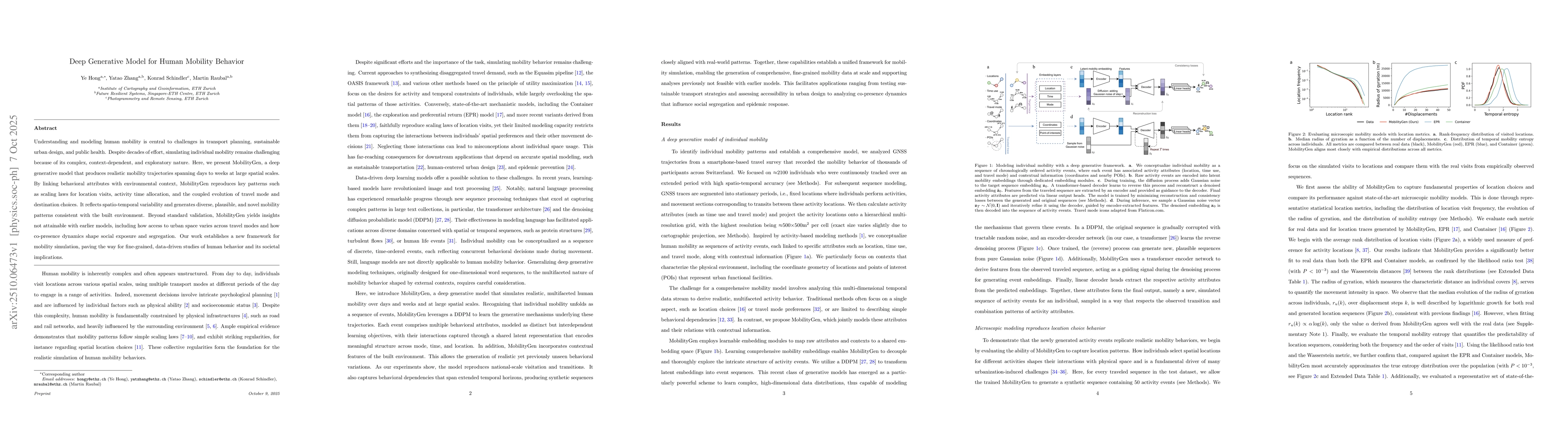
Understanding and modeling human mobility is central to challenges in transport planning, sustainable urban design, and public health. Despite decades of effort, simulating individual mobility remains...
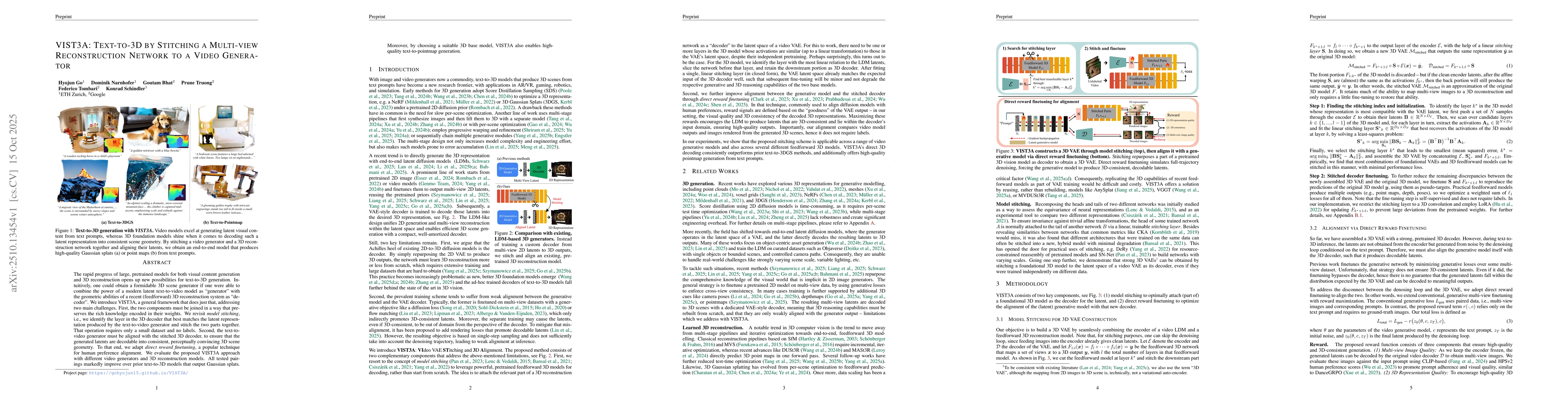
The rapid progress of large, pretrained models for both visual content generation and 3D reconstruction opens up new possibilities for text-to-3D generation. Intuitively, one could obtain a formidable...
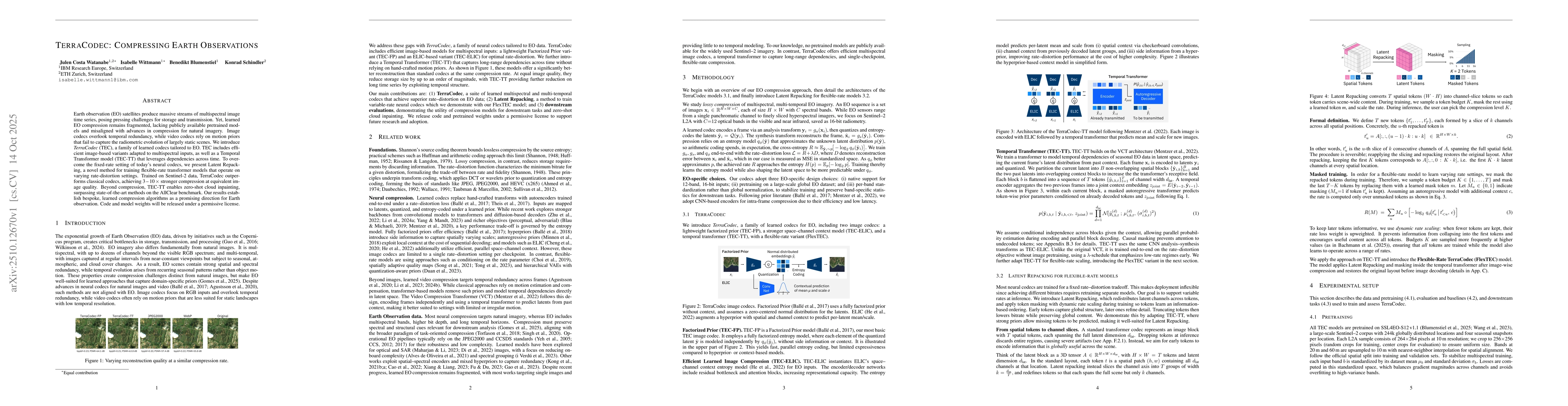
Earth observation (EO) satellites produce massive streams of multispectral image time series, posing pressing challenges for storage and transmission. Yet, learned EO compression remains fragmented, l...
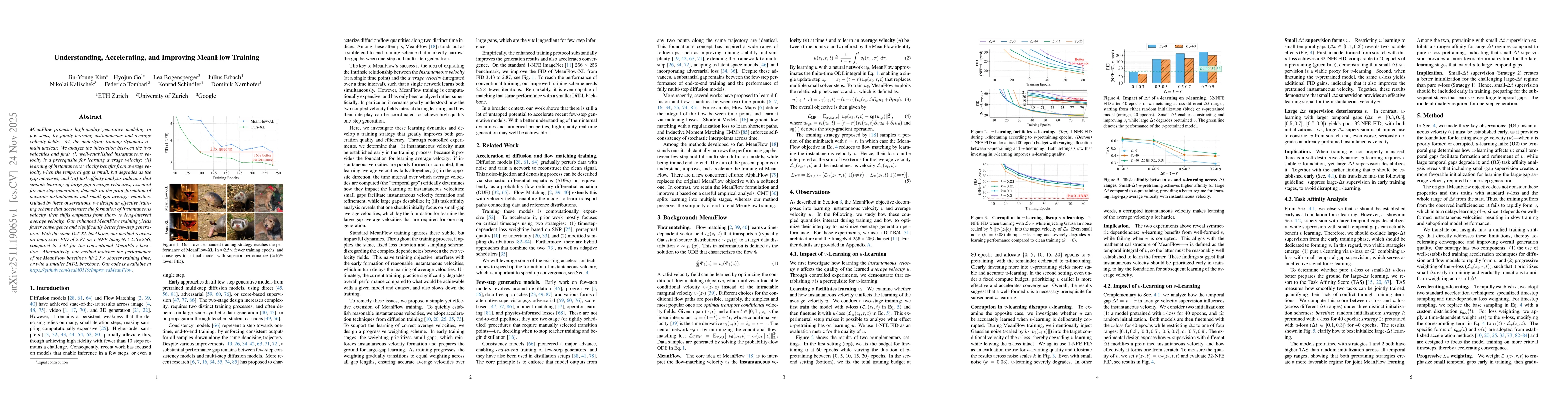
MeanFlow promises high-quality generative modeling in few steps, by jointly learning instantaneous and average velocity fields. Yet, the underlying training dynamics remain unclear. We analyze the int...
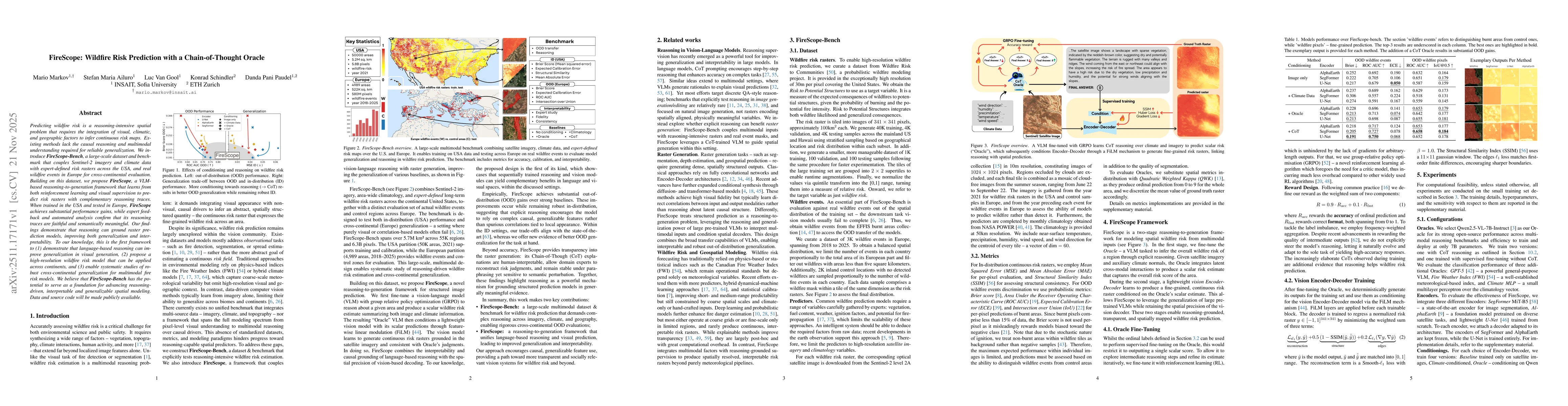
Predicting wildfire risk is a reasoning-intensive spatial problem that requires the integration of visual, climatic, and geographic factors to infer continuous risk maps. Existing methods lack the cau...
Natural disasters demand rapid damage assessment to guide humanitarian response. Here, we investigate whether medium-resolution Earth observation images from the Copernicus program can support buildin...
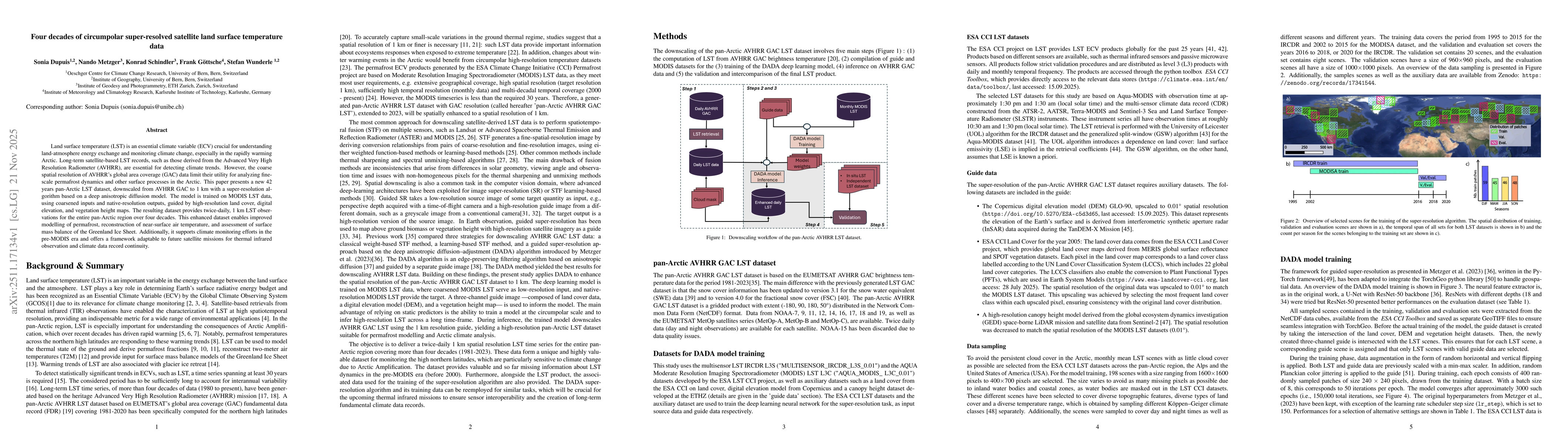
Land surface temperature (LST) is an essential climate variable (ECV) crucial for understanding land-atmosphere energy exchange and monitoring climate change, especially in the rapidly warming Arctic....
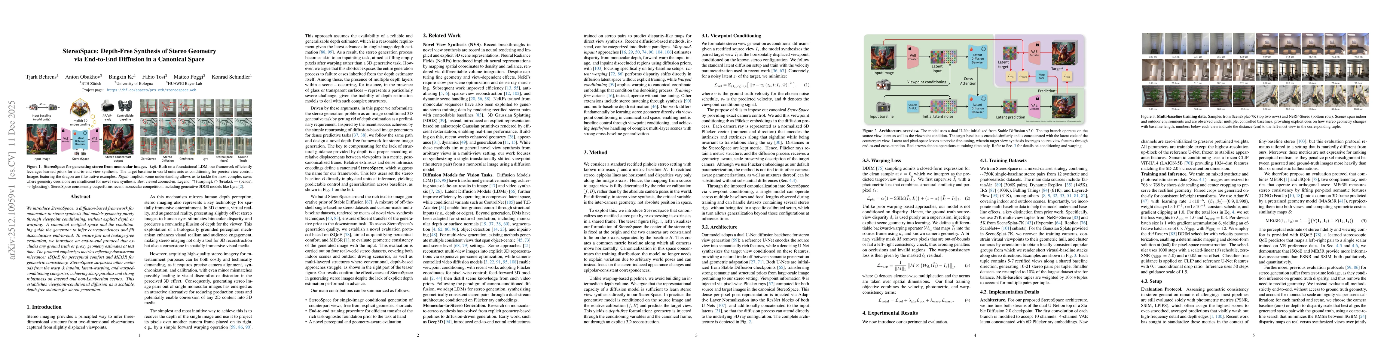
We introduce StereoSpace, a diffusion-based framework for monocular-to-stereo synthesis that models geometry purely through viewpoint conditioning, without explicit depth or warping. A canonical recti...
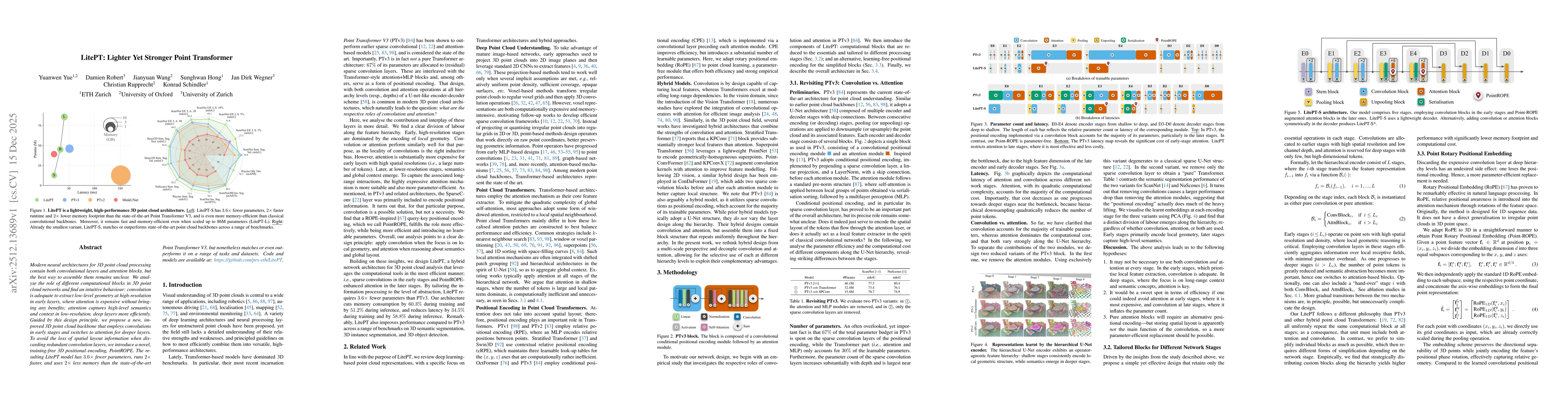
Modern neural architectures for 3D point cloud processing contain both convolutional layers and attention blocks, but the best way to assemble them remains unclear. We analyse the role of different co...
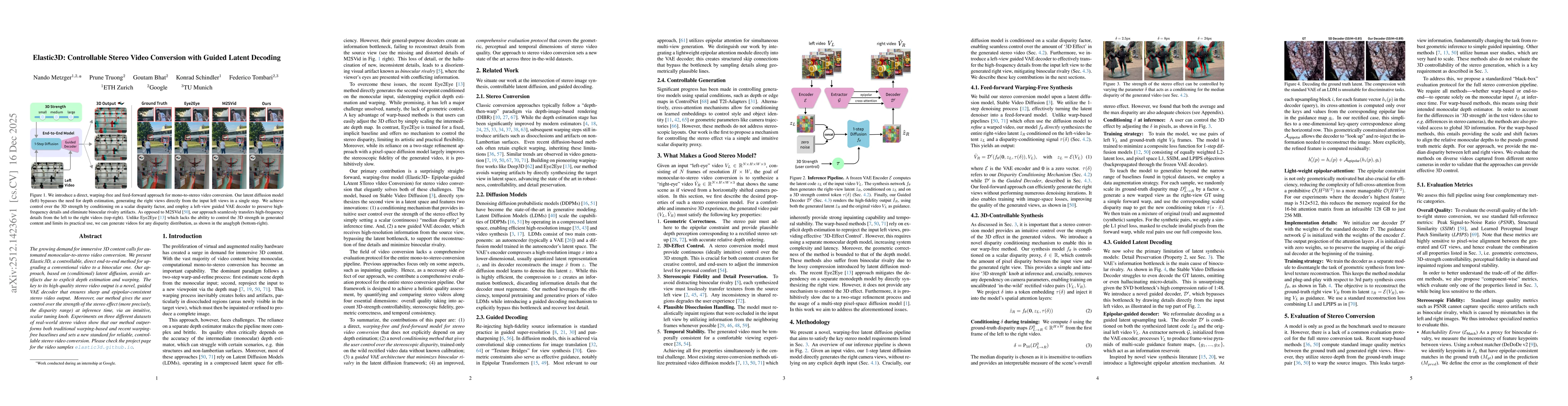
The growing demand for immersive 3D content calls for automated monocular-to-stereo video conversion. We present Elastic3D, a controllable, direct end-to-end method for upgrading a conventional video ...
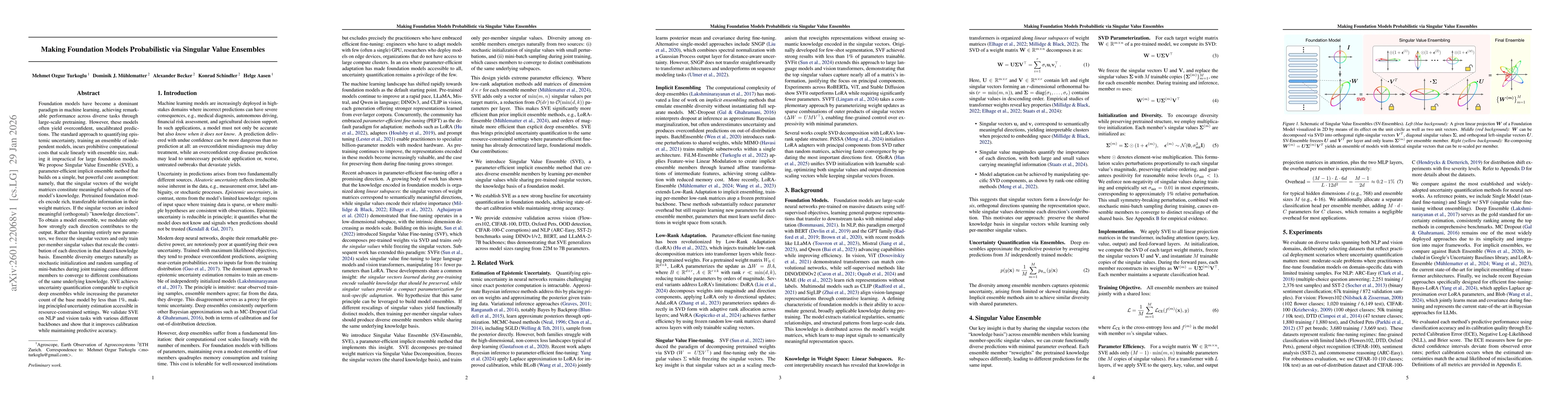
Foundation models have become a dominant paradigm in machine learning, achieving remarkable performance across diverse tasks through large-scale pretraining. However, these models often yield overconf...
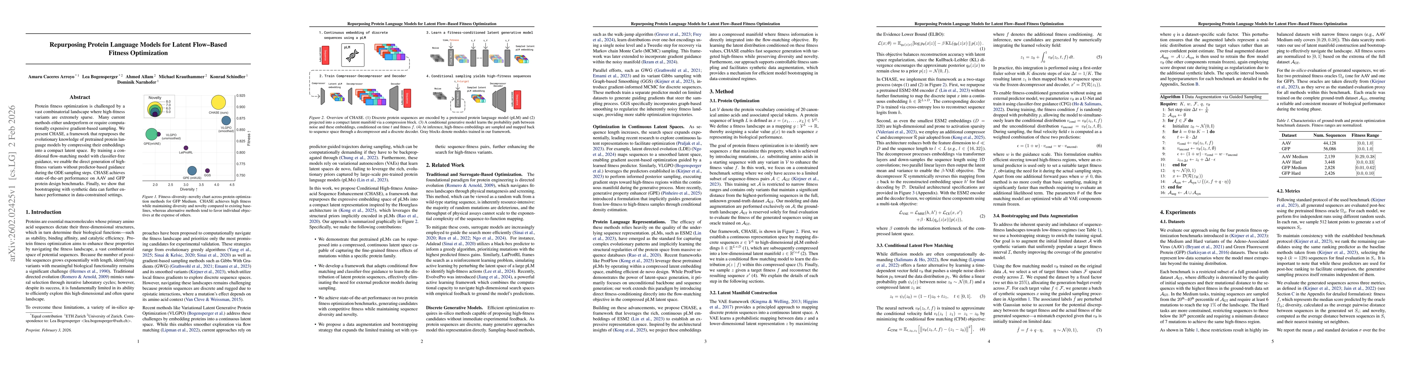
Protein fitness optimization is challenged by a vast combinatorial landscape where high-fitness variants are extremely sparse. Many current methods either underperform or require computationally expen...
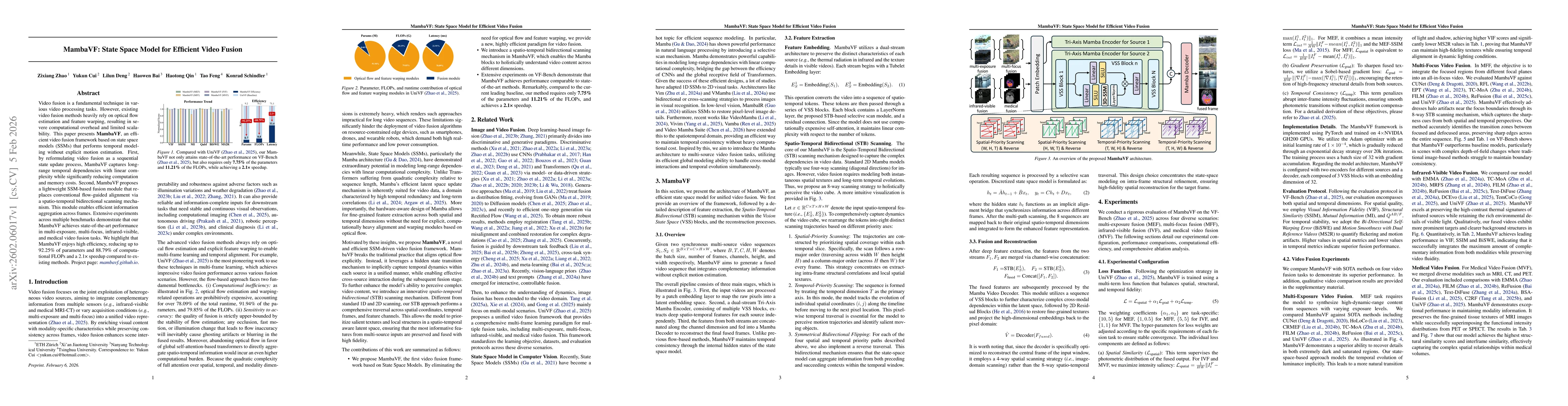
Video fusion is a fundamental technique in various video processing tasks. However, existing video fusion methods heavily rely on optical flow estimation and feature warping, resulting in severe compu...
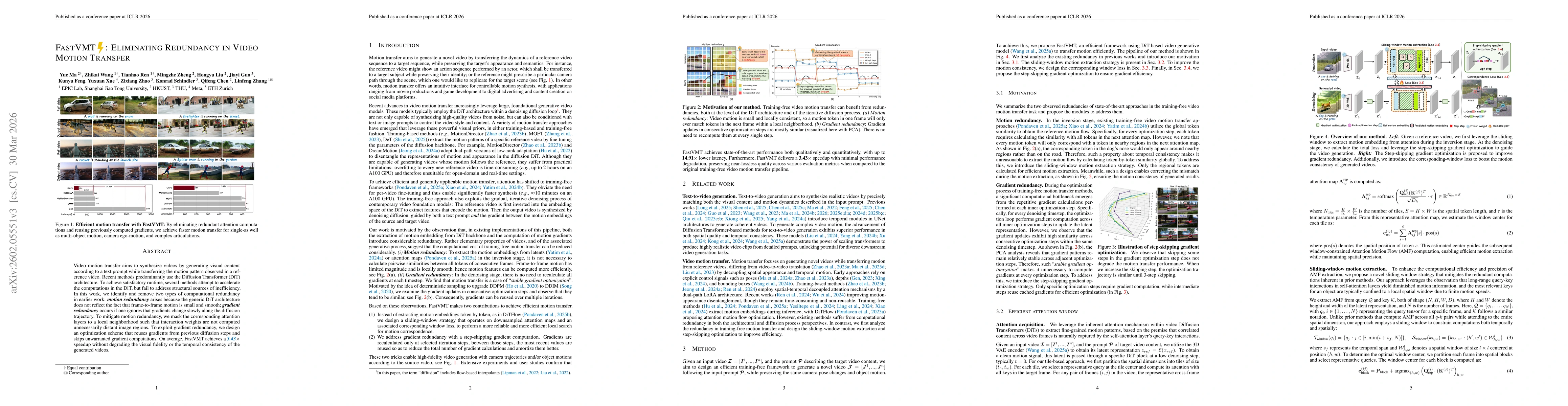
Video motion transfer aims to synthesize videos by generating visual content according to a text prompt while transferring the motion pattern observed in a reference video. Recent methods predominantl...
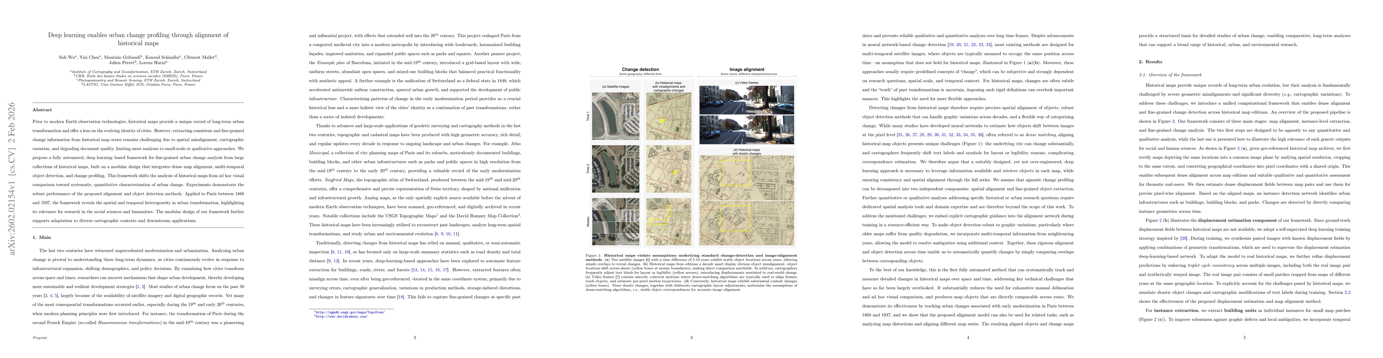
Prior to modern Earth observation technologies, historical maps provide a unique record of long-term urban transformation and offer a lens on the evolving identity of cities. However, extracting consi...
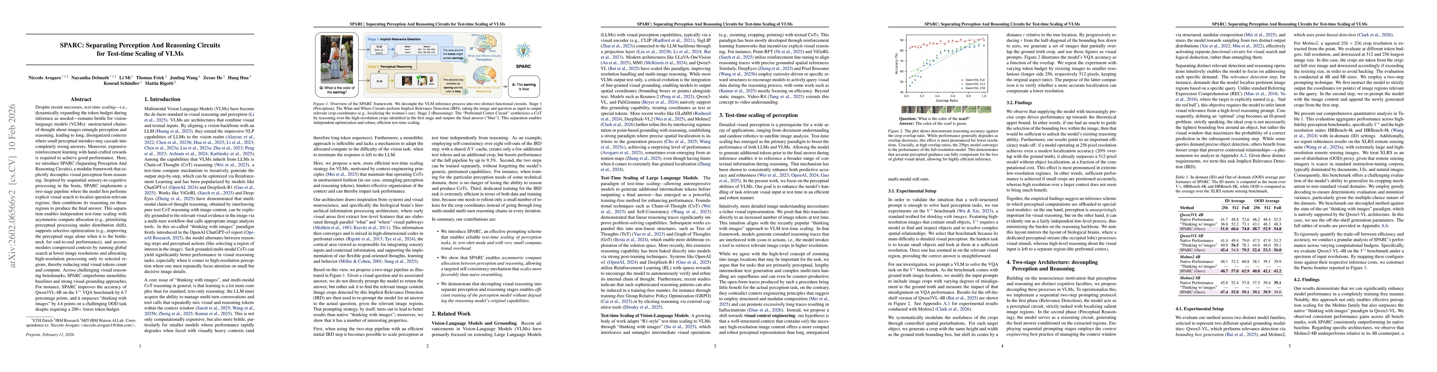
Despite recent successes, test-time scaling - i.e., dynamically expanding the token budget during inference as needed - remains brittle for vision-language models (VLMs): unstructured chains-of-though...
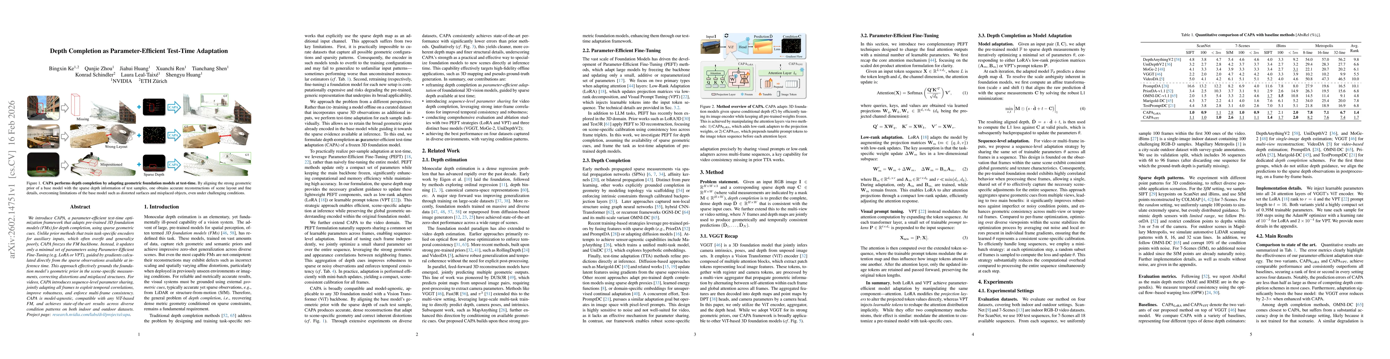
We introduce CAPA, a parameter-efficient test-time optimization framework that adapts pre-trained 3D foundation models (FMs) for depth completion, using sparse geometric cues. Unlike prior methods tha...
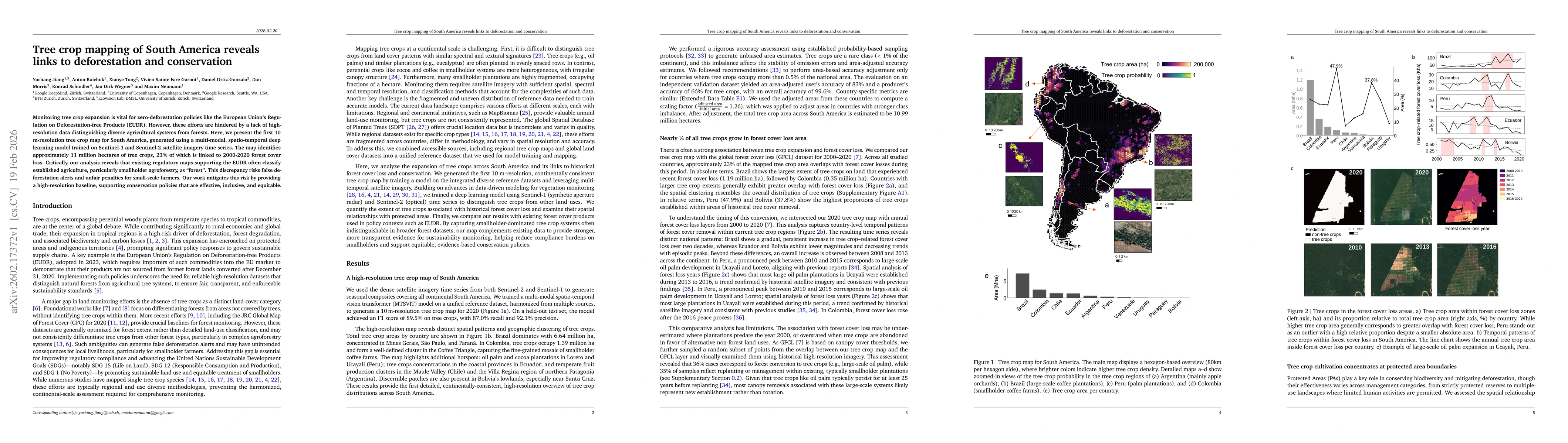
Monitoring tree crop expansion is vital for zero-deforestation policies like the European Union's Regulation on Deforestation-free Products (EUDR). However, these efforts are hindered by a lack of hig...
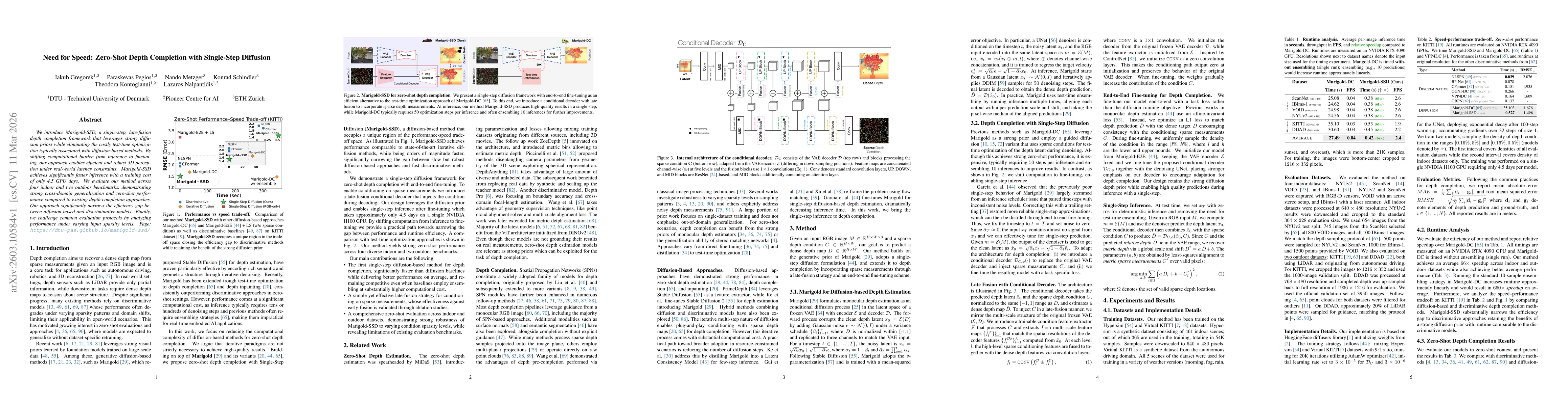
We introduce Marigold-SSD, a single-step, late-fusion depth completion framework that leverages strong diffusion priors while eliminating the costly test-time optimization typically associated with di...
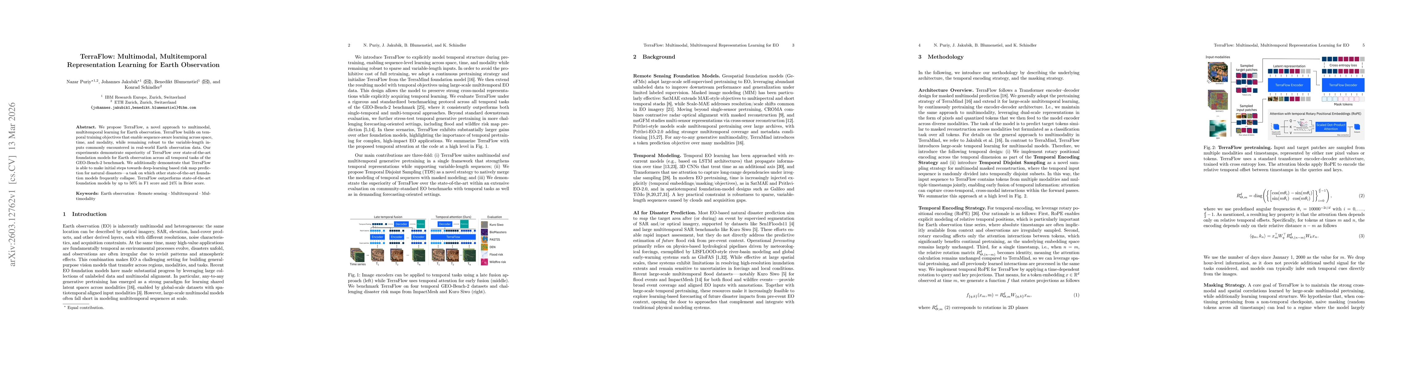
We propose TerraFlow, a novel approach to multimodal, multitemporal learning for Earth observation. TerraFlow builds on temporal training objectives that enable sequence-aware learning across space, t...
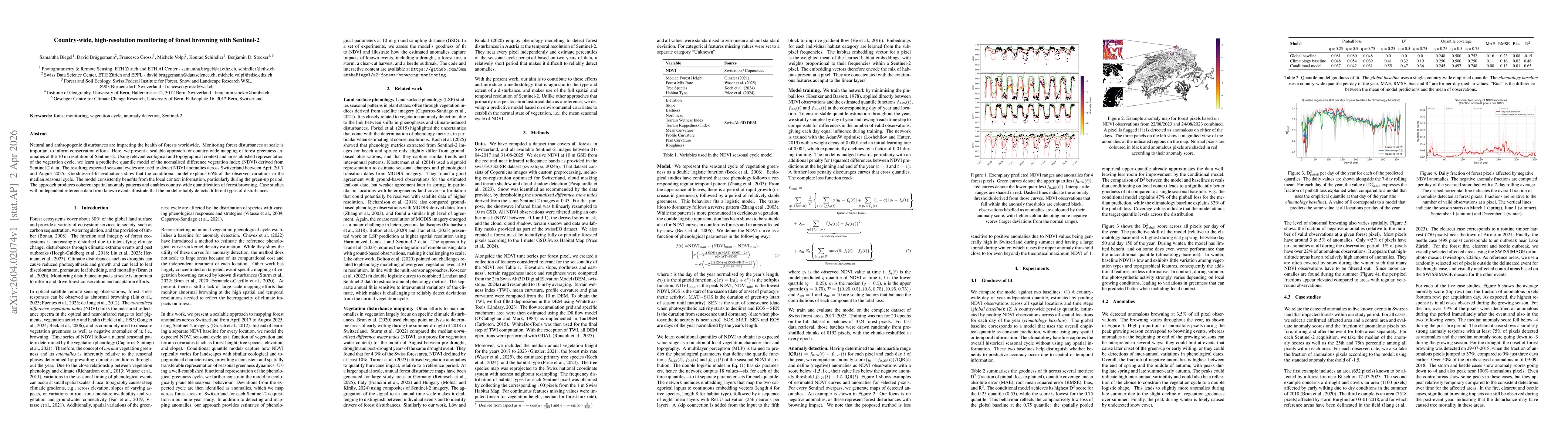
Natural and anthropogenic disturbances are impacting the health of forests worldwide. Monitoring forest disturbances at scale is important to inform conservation efforts. Here, we present a scalable a...
Domain adaptation (DA) addresses the challenge of transferring a machine learning model trained on a source domain to a target domain with a different data distribution. In this work, we study DA for ...
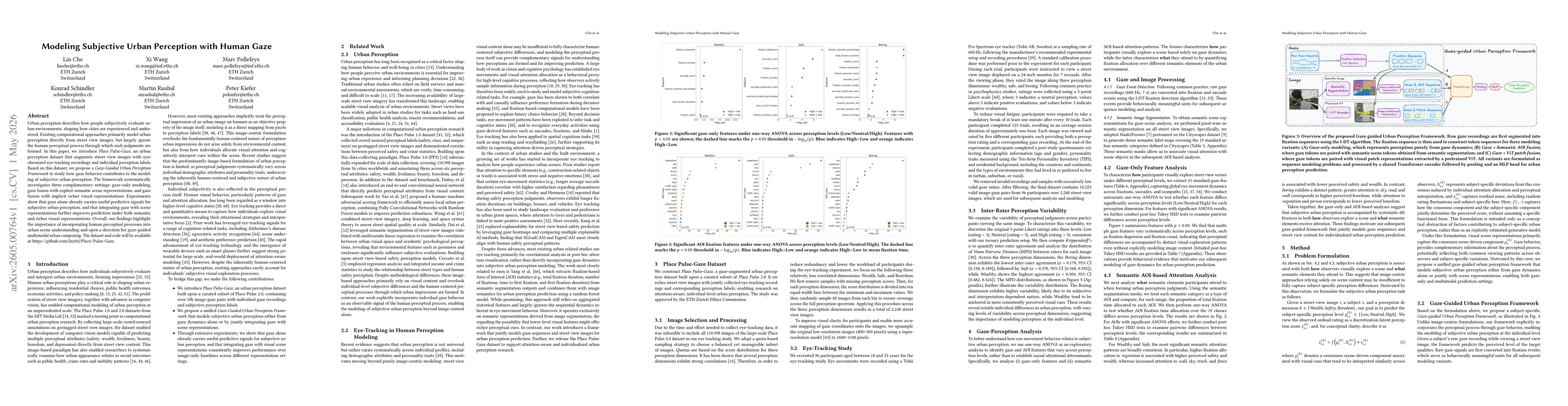
Urban perception describes how people subjectively evaluate urban environments, shaping how cities are experienced and understood. Existing computational approaches primarily model urban perception di...
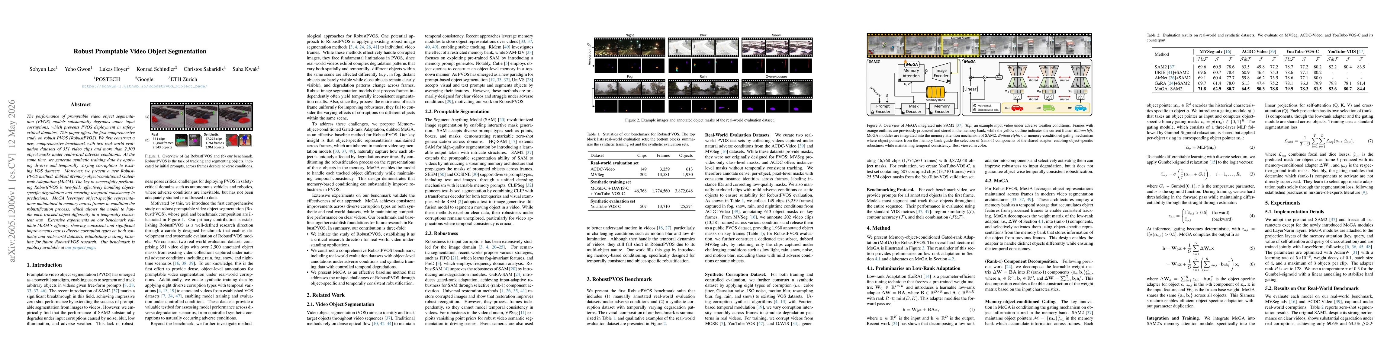
The performance of promptable video object segmentation (PVOS) models substantially degrades under input corruptions, which prevents PVOS deployment in safety-critical domains. This paper offers the f...
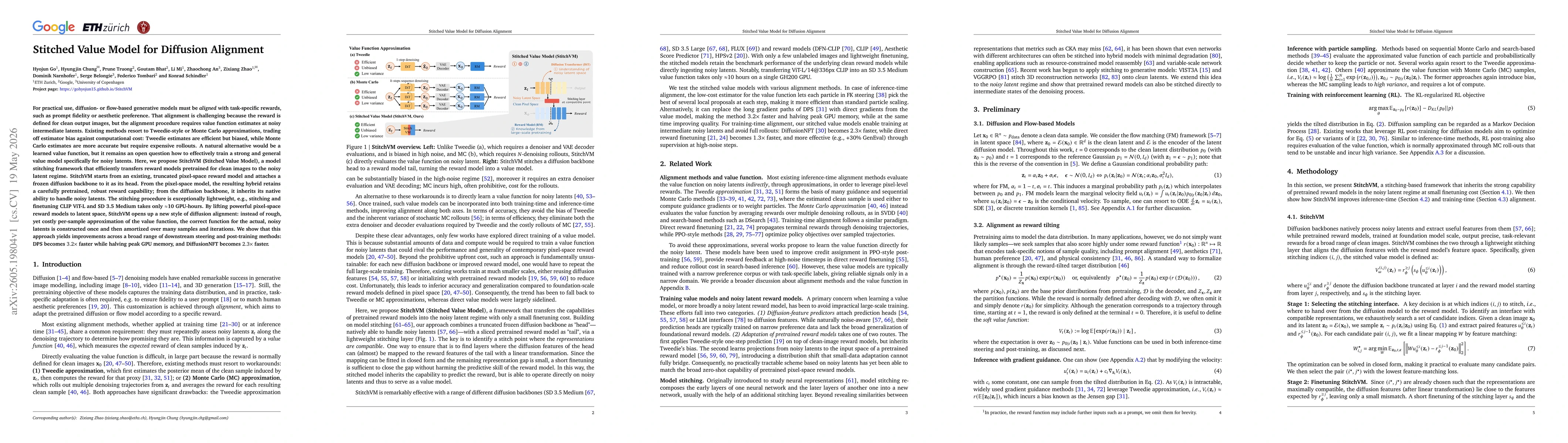
For practical use, diffusion- or flow-based generative models must be aligned with task-specific rewards, such as prompt fidelity or aesthetic preference. That alignment is challenging because the rew...

For practical use, diffusion- or flow-based generative models must be aligned with task-specific rewards, such as prompt fidelity or aesthetic preference. That alignment is challenging because the rew...
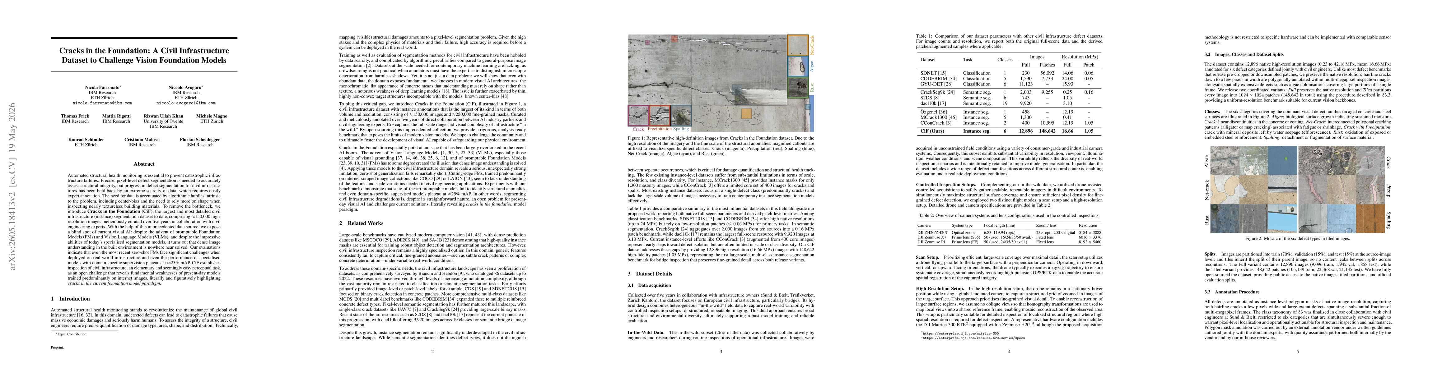
Automated structural health monitoring is essential to prevent catastrophic infrastructure failures. Precise, pixel-level defect segmentation is needed to accurately assess structural integrity, but p...
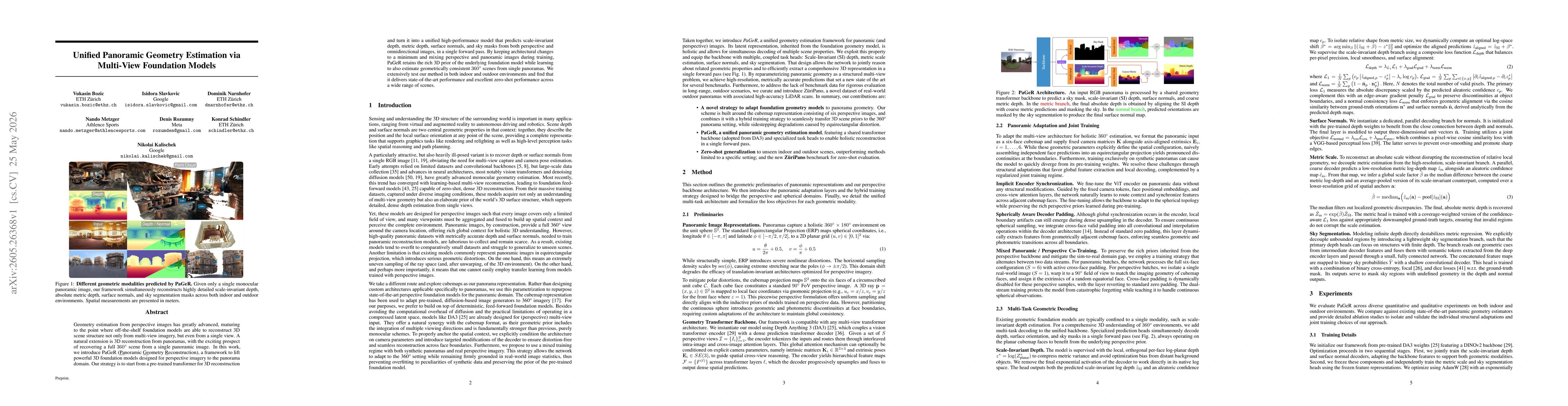
Geometry estimation from perspective images has greatly advanced, maturing to the point where off-the-shelf foundation models are able to reconstruct 3D scene structure not only from multi-view imager...