ImpliCity: City Modeling from Satellite Images with Deep Implicit Occupancy Fields
Publication
Metrics
AI Quick Summary
ImpliCity reconstructs high-quality 3D city models from satellite images using a neural implicit occupancy field, achieving a median height error of 0.7 m and outperforming traditional methods by capturing intricate details and smooth surfaces.
Paper Preview
Abstract
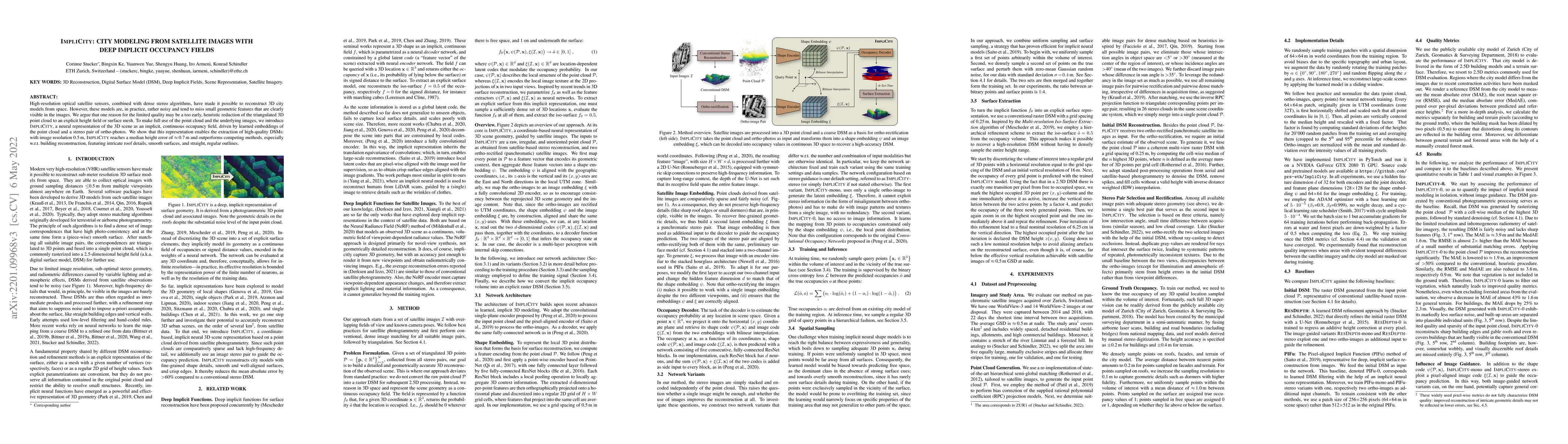
High-resolution optical satellite sensors, combined with dense stereo algorithms, have made it possible to reconstruct 3D city models from space. However, these models are, in practice, rather noisy and tend to miss small geometric features that are clearly visible in the images. We argue that one reason for the limited quality may be a too early, heuristic reduction of the triangulated 3D point cloud to an explicit height field or surface mesh. To make full use of the point cloud and the underlying images, we introduce ImpliCity, a neural representation of the 3D scene as an implicit, continuous occupancy field, driven by learned embeddings of the point cloud and a stereo pair of ortho-photos. We show that this representation enables the extraction of high-quality DSMs: with image resolution 0.5$\,$m, ImpliCity reaches a median height error of $\approx\,$0.7$\,$m and outperforms competing methods, especially w.r.t. building reconstruction, featuring intricate roof details, smooth surfaces, and straight, regular outlines.
AI Key Findings
Get AI-generated insights about this paper's methodology, results, significance, and more — seven facets brought into focus.
Impact
Paper Details
Authors
PDF Preview
Key Terms
Citation Network
Current paper (gray), citations (green), references (blue)
Display is limited for performance on very large graphs.
Discussion 0