Academic Profile
Statistics
Similar Authors
Papers on arXiv
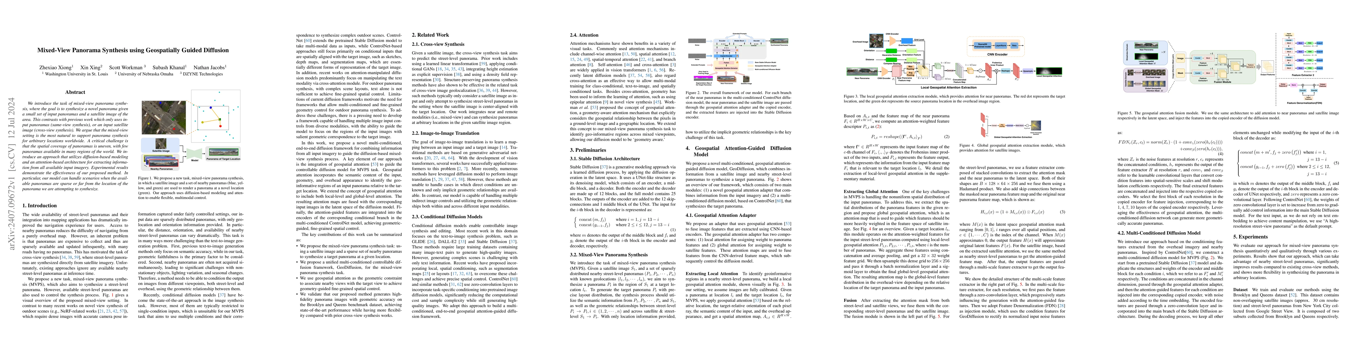
We introduce the task of mixed-view panorama synthesis, where the goal is to synthesize a novel panorama given a small set of input panoramas and a satellite image of the area. This contrasts with pre...
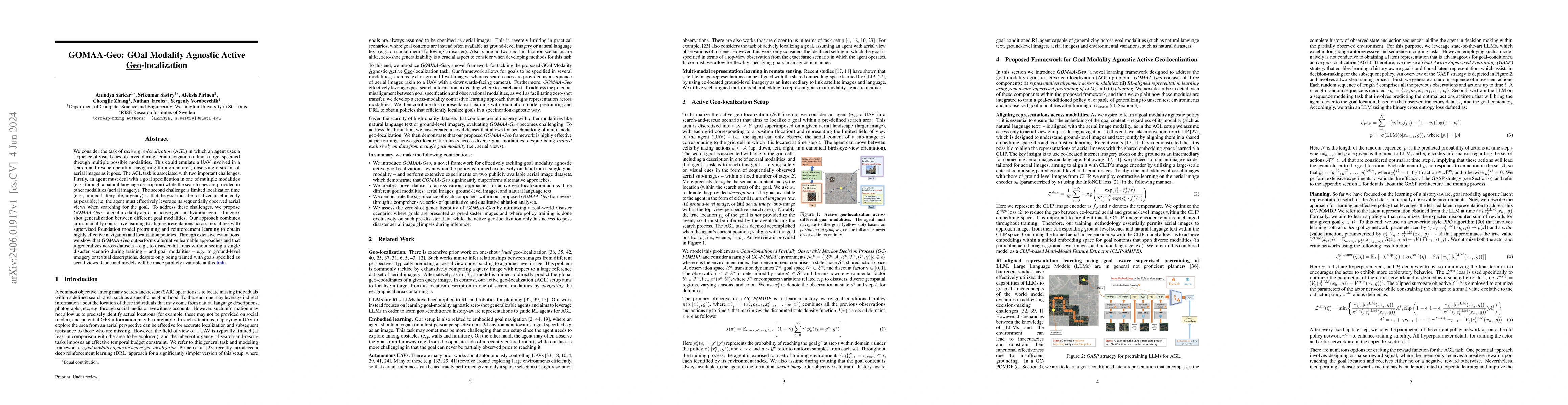
We consider the task of active geo-localization (AGL) in which an agent uses a sequence of visual cues observed during aerial navigation to find a target specified through multiple possible modaliti...
In remote sensing, we are interested in modeling various modalities for some geographic location. Several works have focused on learning the relationship between a location and type of landscape, ha...
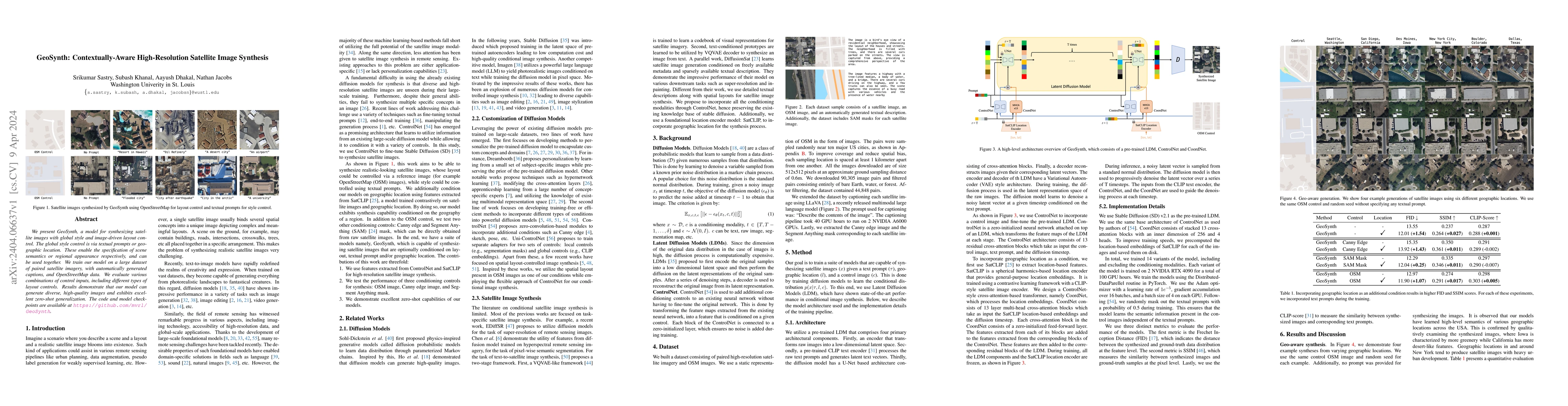
We present GeoSynth, a model for synthesizing satellite images with global style and image-driven layout control. The global style control is via textual prompts or geographic location. These enable...
Deep reinforcement learning has demonstrated remarkable achievements across diverse domains such as video games, robotic control, autonomous driving, and drug discovery. Common methodologies in part...
We focus on the problem of species distribution modeling using global-scale presence-only data. Most previous studies have mapped the range of a given species using geographical and environmental fe...
In critical operations where aerial imagery plays an essential role, the integrity and trustworthiness of data are paramount. The emergence of adversarial attacks, particularly those that exploit co...
We propose a metadata-aware self-supervised learning~(SSL)~framework useful for fine-grained classification and ecological mapping of bird species around the world. Our framework unifies two SSL str...
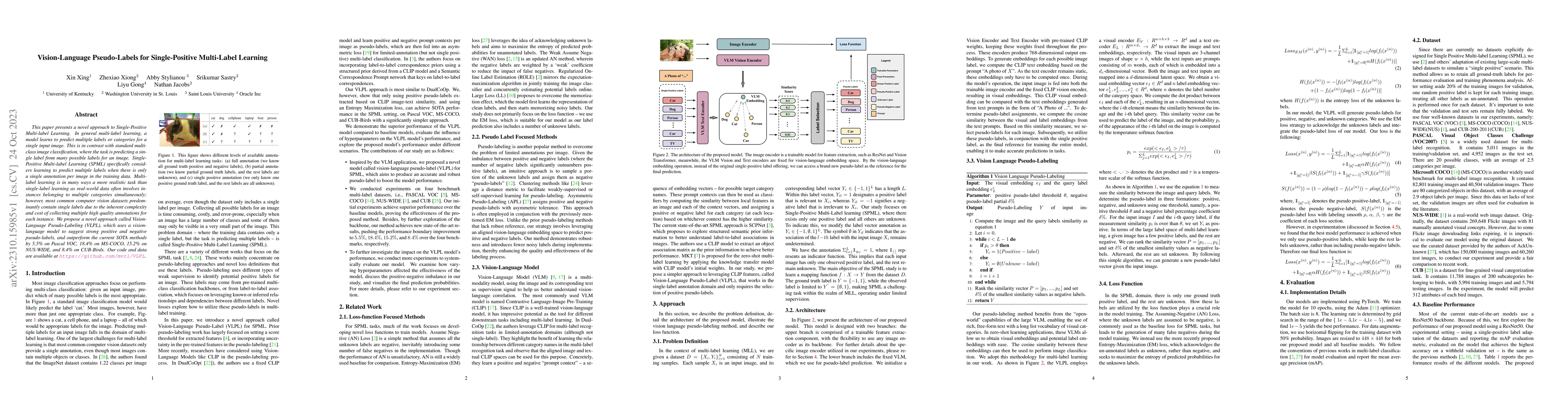
This paper presents a novel approach to Single-Positive Multi-label Learning. In general multi-label learning, a model learns to predict multiple labels or categories for a single input image. This ...
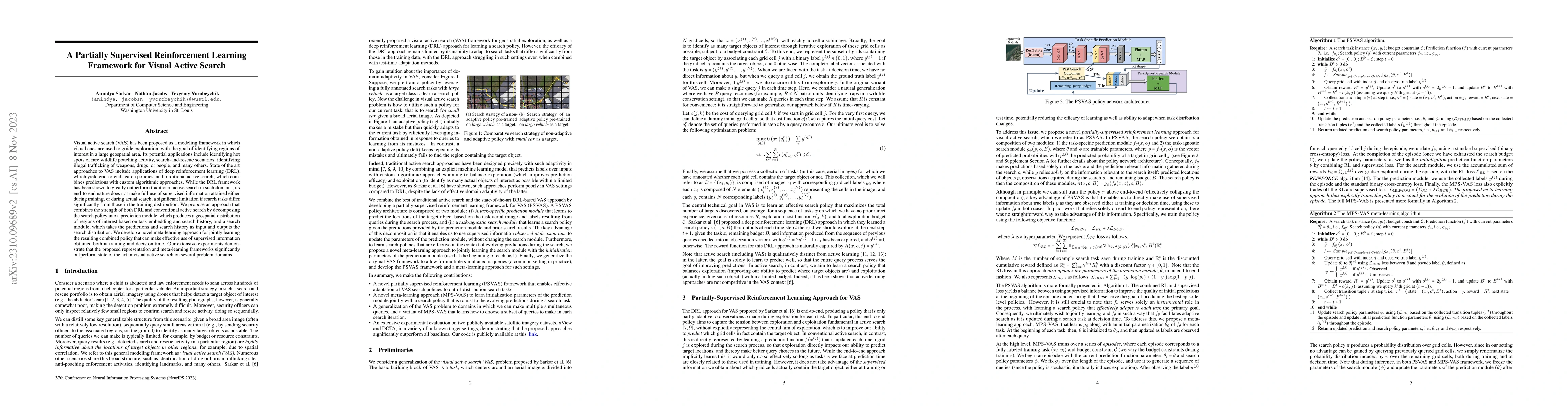
Visual active search (VAS) has been proposed as a modeling framework in which visual cues are used to guide exploration, with the goal of identifying regions of interest in a large geospatial area. ...
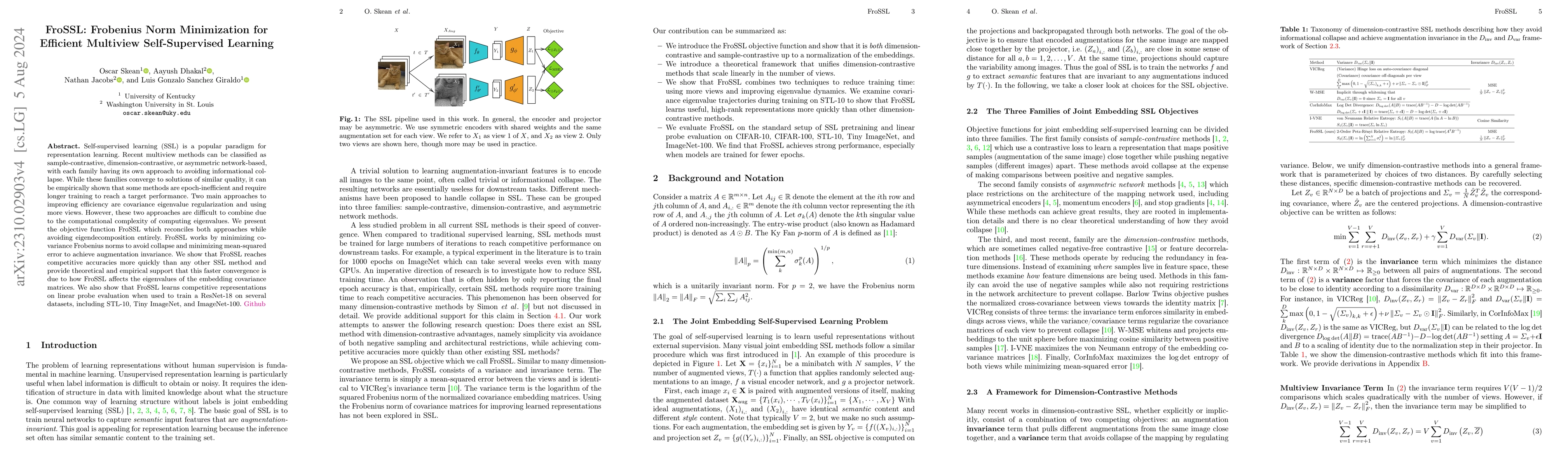
Self-supervised learning (SSL) is a popular paradigm for representation learning. Recent multiview methods can be classified as sample-contrastive, dimension-contrastive, or asymmetric network-based...
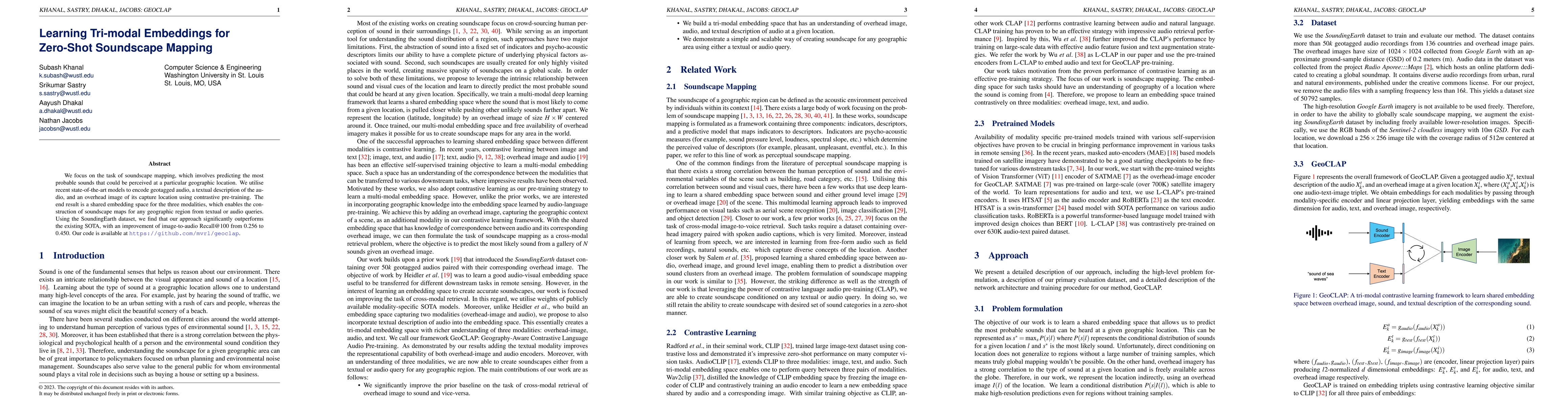
We focus on the task of soundscape mapping, which involves predicting the most probable sounds that could be perceived at a particular geographic location. We utilise recent state-of-the-art models ...
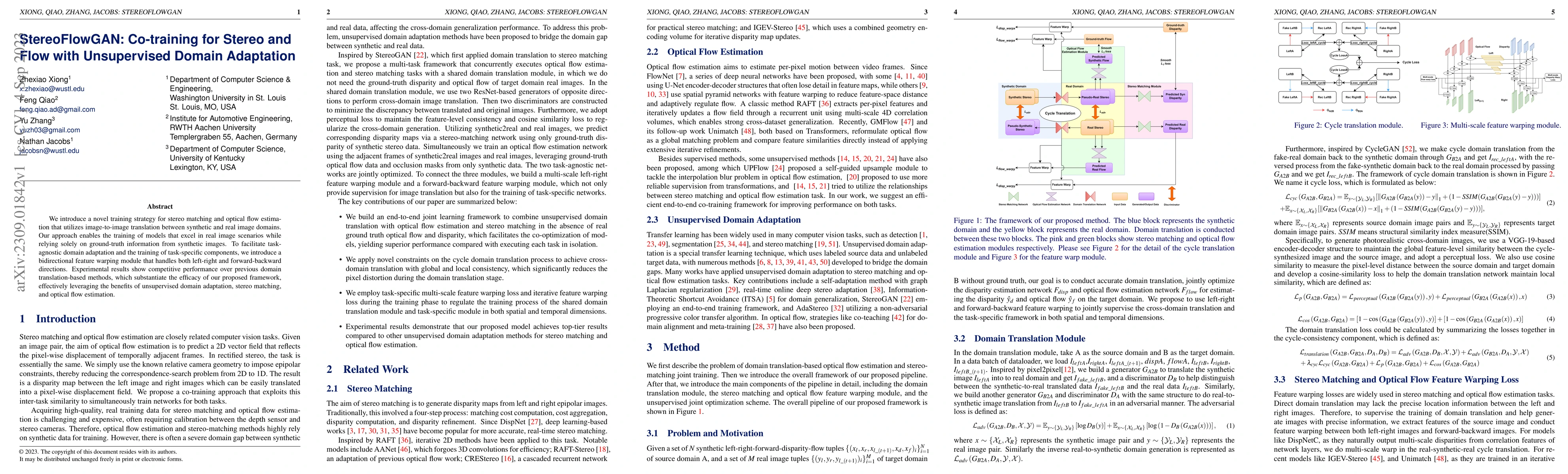
We introduce a novel training strategy for stereo matching and optical flow estimation that utilizes image-to-image translation between synthetic and real image domains. Our approach enables the tra...
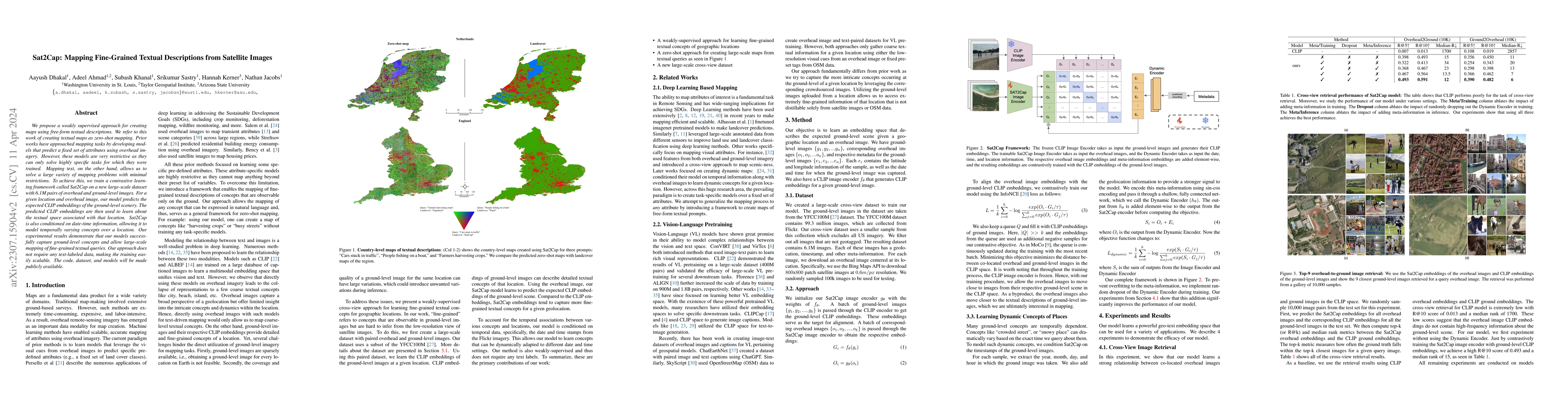
We propose a weakly supervised approach for creating maps using free-form textual descriptions. We refer to this work of creating textual maps as zero-shot mapping. Prior works have approached mappi...
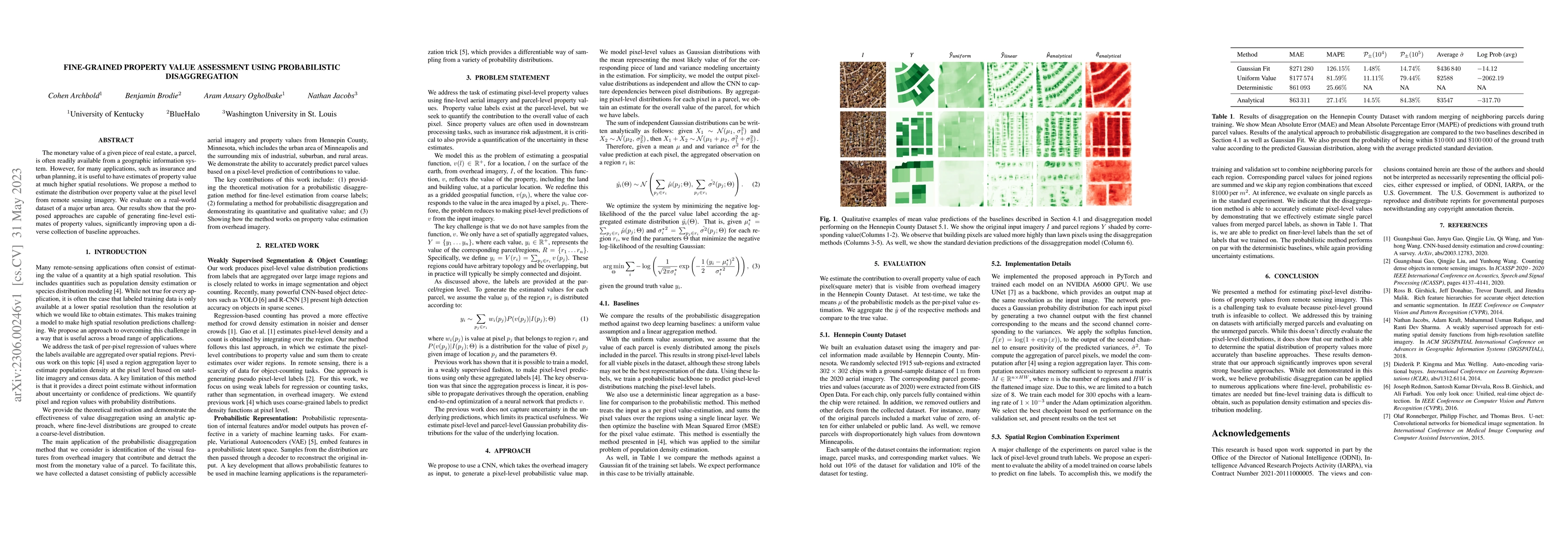
The monetary value of a given piece of real estate, a parcel, is often readily available from a geographic information system. However, for many applications, such as insurance and urban planning, i...
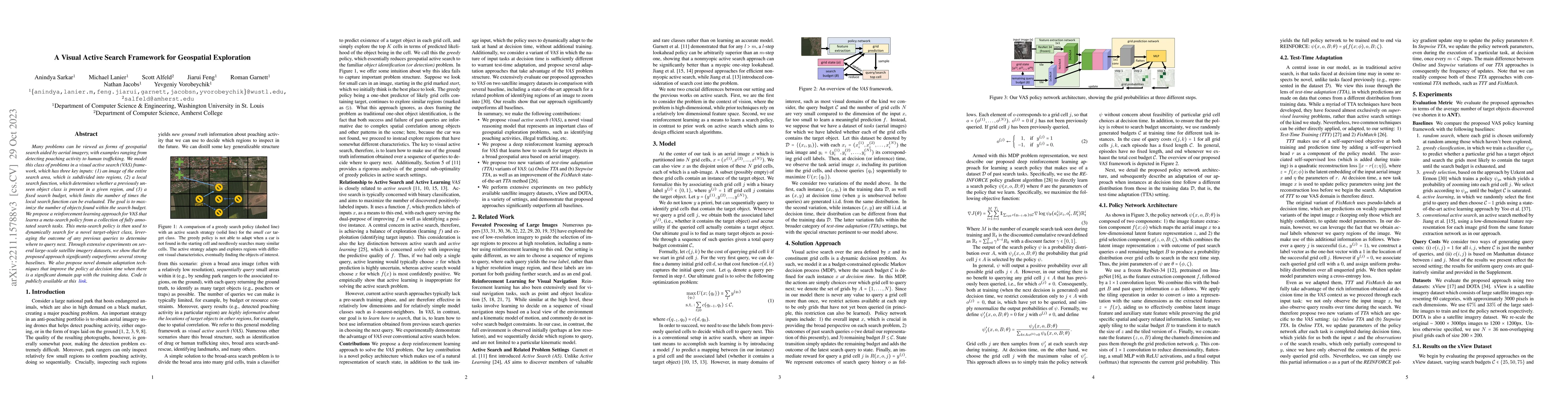
Many problems can be viewed as forms of geospatial search aided by aerial imagery, with examples ranging from detecting poaching activity to human trafficking. We model this class of problems in a v...
As unconventional sources of geo-information, massive imagery and text messages from open platforms and social media form a temporally quasi-seamless, spatially multi-perspective stream, but with un...
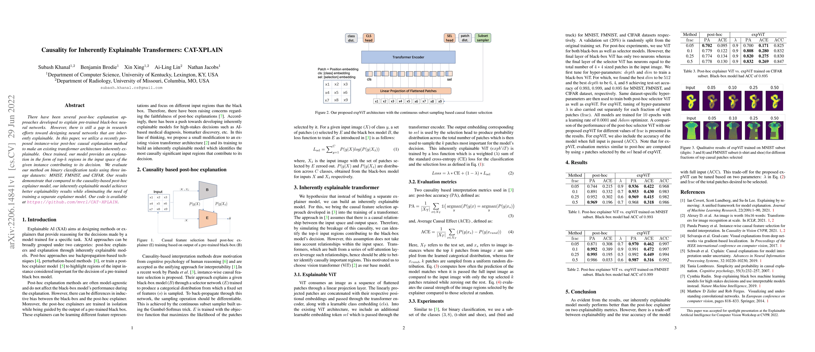
There have been several post-hoc explanation approaches developed to explain pre-trained black-box neural networks. However, there is still a gap in research efforts toward designing neural networks...
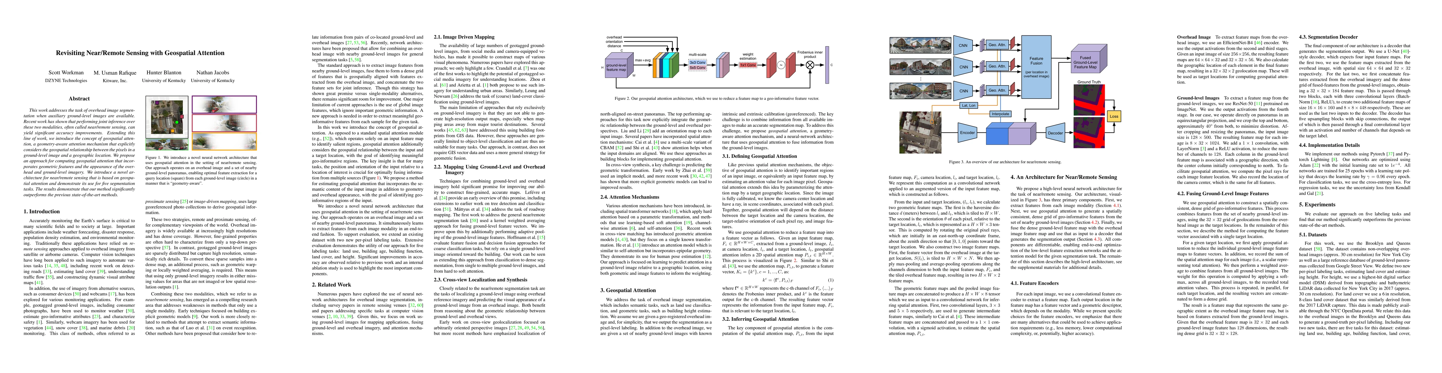
This work addresses the task of overhead image segmentation when auxiliary ground-level images are available. Recent work has shown that performing joint inference over these two modalities, often c...
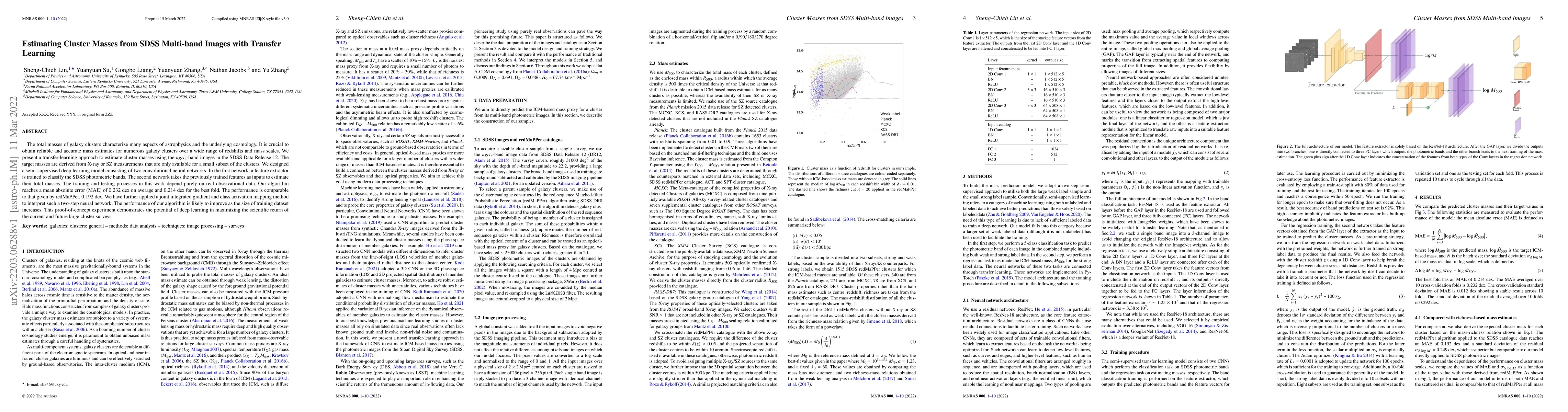
The total masses of galaxy clusters characterize many aspects of astrophysics and the underlying cosmology. It is crucial to obtain reliable and accurate mass estimates for numerous galaxy clusters ...
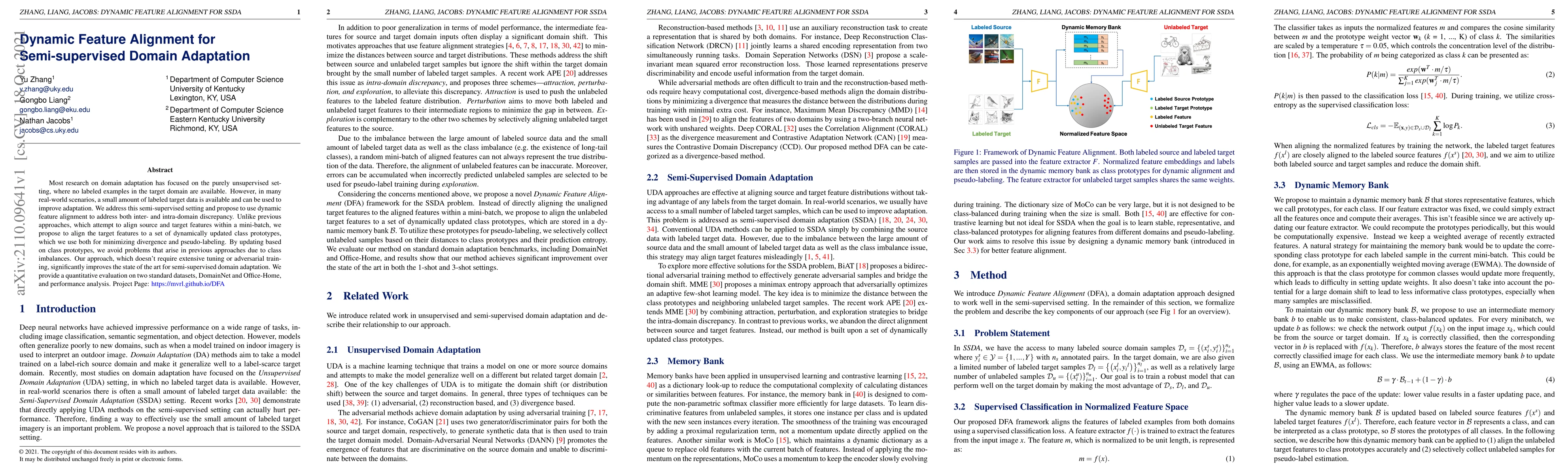
Most research on domain adaptation has focused on the purely unsupervised setting, where no labeled examples in the target domain are available. However, in many real-world scenarios, a small amount...
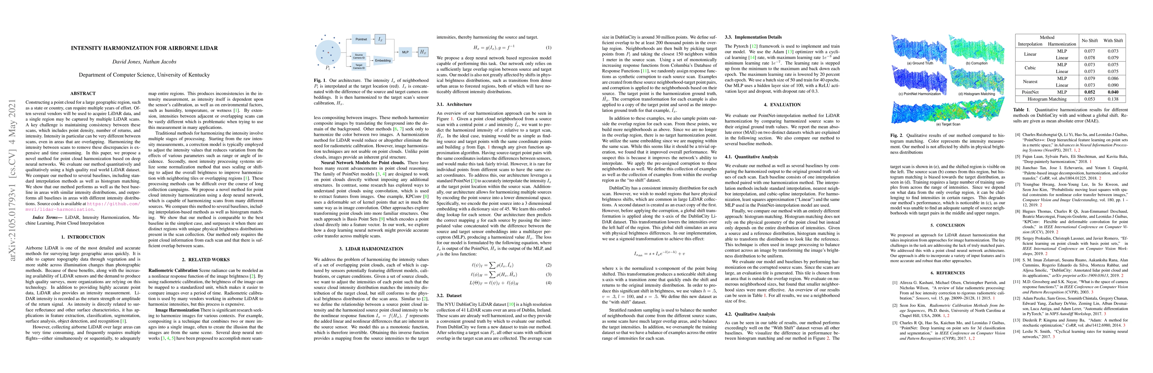
Constructing a point cloud for a large geographic region, such as a state or country, can require multiple years of effort. Often several vendors will be used to acquire LiDAR data, and a single reg...
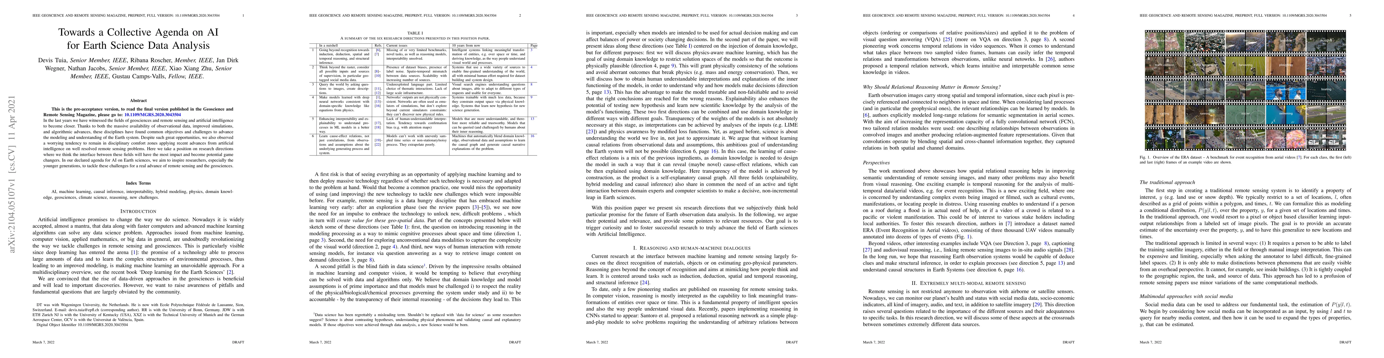
In the last years we have witnessed the fields of geosciences and remote sensing and artificial intelligence to become closer. Thanks to both the massive availability of observational data, improved...
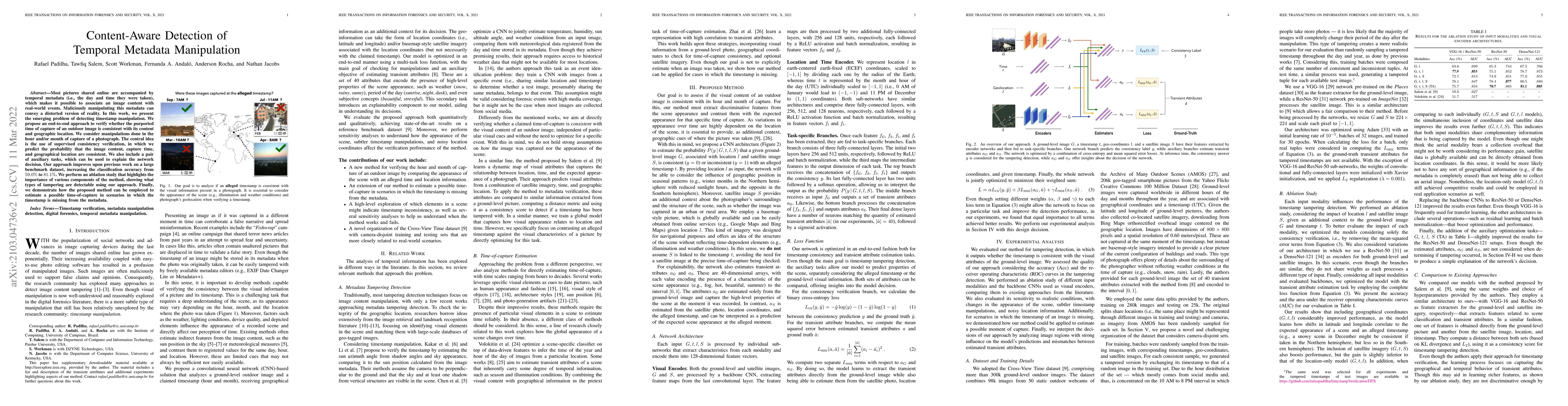
Most pictures shared online are accompanied by temporal metadata (i.e., the day and time they were taken), which makes it possible to associate an image content with real-world events. Maliciously m...
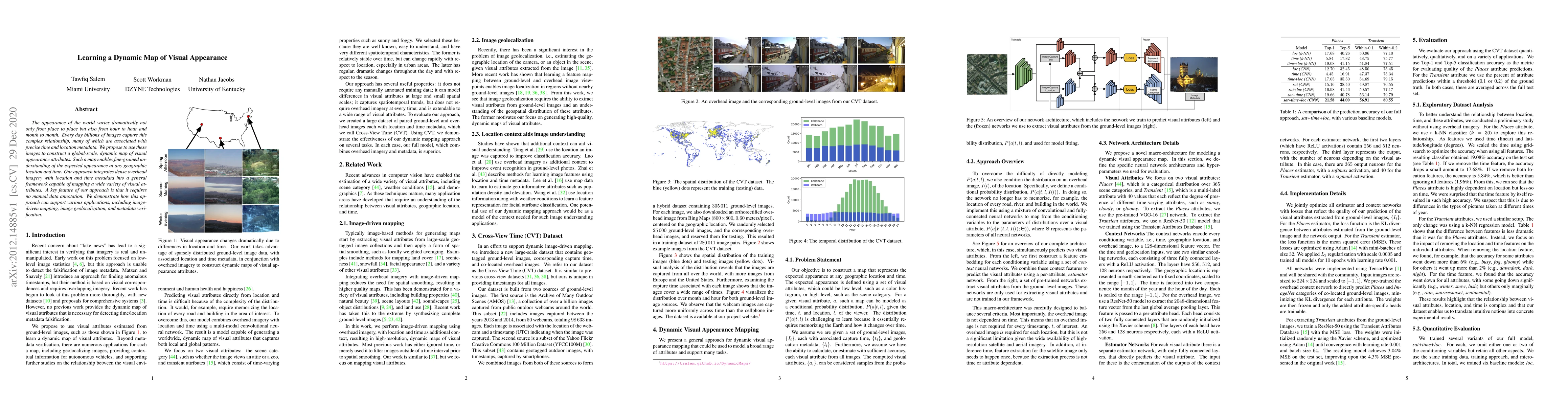
The appearance of the world varies dramatically not only from place to place but also from hour to hour and month to month. Every day billions of images capture this complex relationship, many of wh...
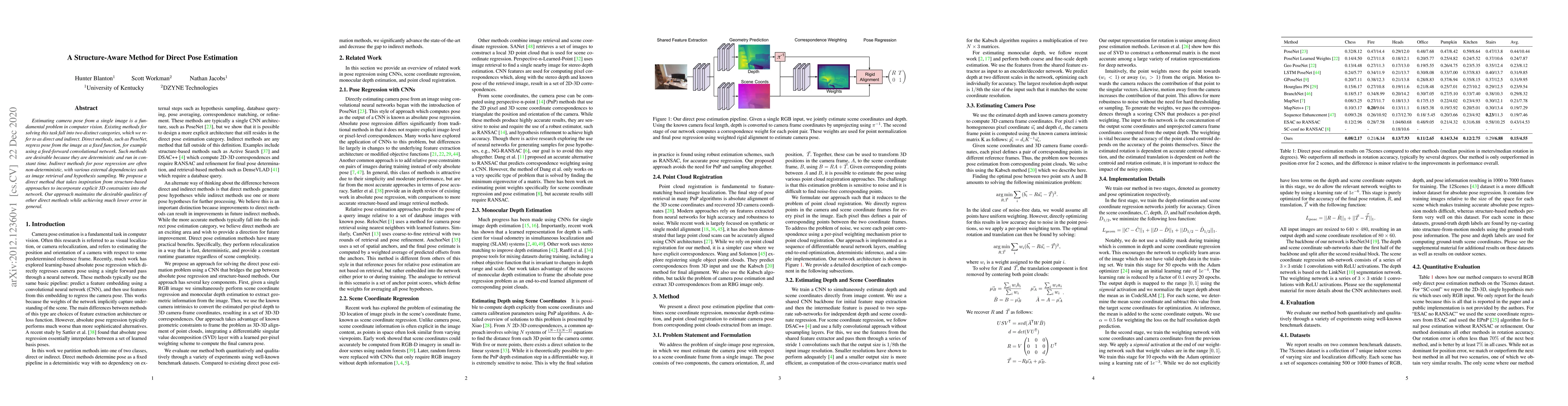
Estimating camera pose from a single image is a fundamental problem in computer vision. Existing methods for solving this task fall into two distinct categories, which we refer to as direct and indi...
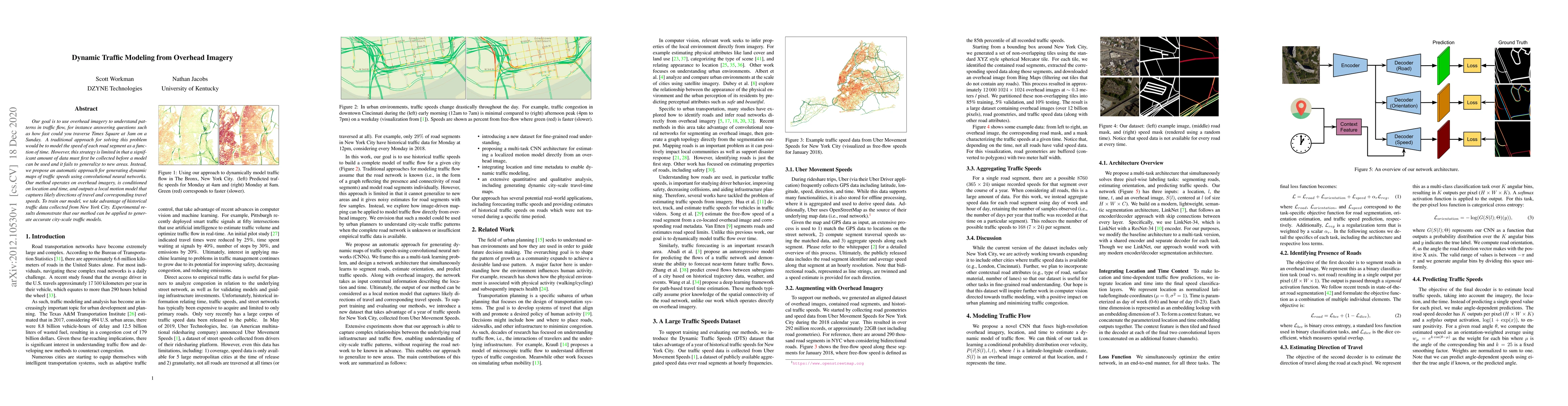
Our goal is to use overhead imagery to understand patterns in traffic flow, for instance answering questions such as how fast could you traverse Times Square at 3am on a Sunday. A traditional approa...
Most galaxies in the nearby Universe are gravitationally bound to a cluster or group of galaxies. Their optical contents, such as optical richness, are crucial for understanding the co-evolution of ...
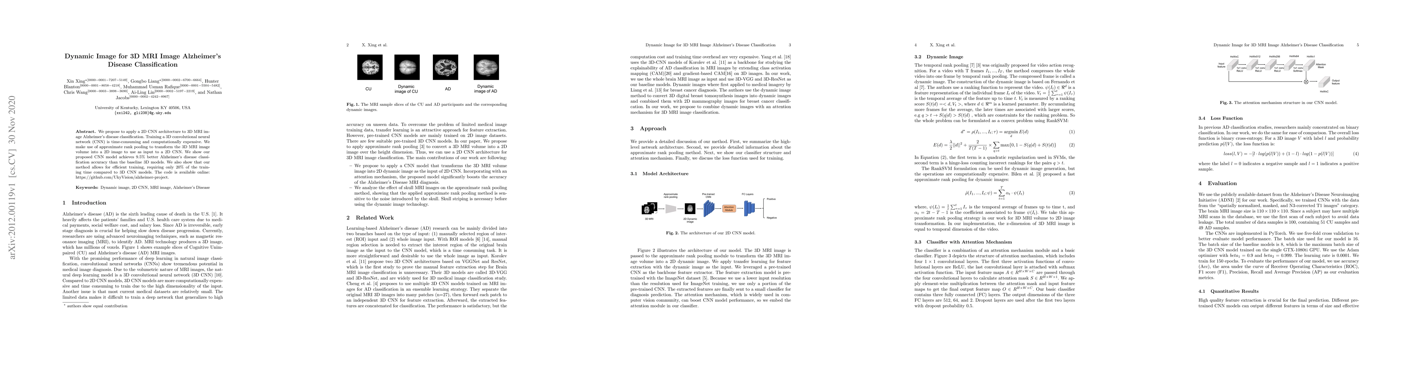
We propose to apply a 2D CNN architecture to 3D MRI image Alzheimer's disease classification. Training a 3D convolutional neural network (CNN) is time-consuming and computationally expensive. We mak...
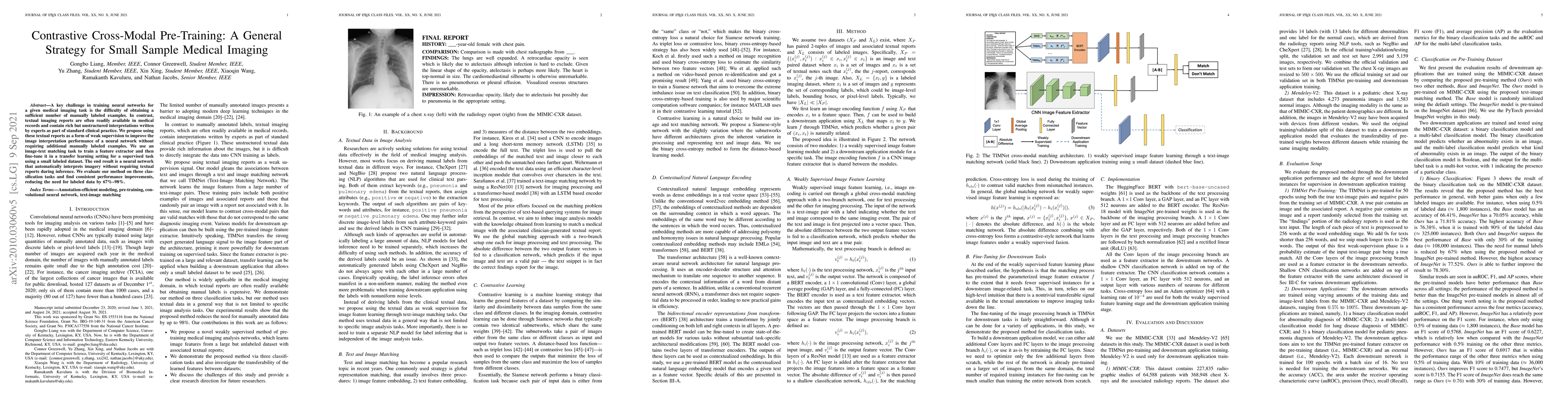
A key challenge in training neural networks for a given medical imaging task is often the difficulty of obtaining a sufficient number of manually labeled examples. In contrast, textual imaging repor...
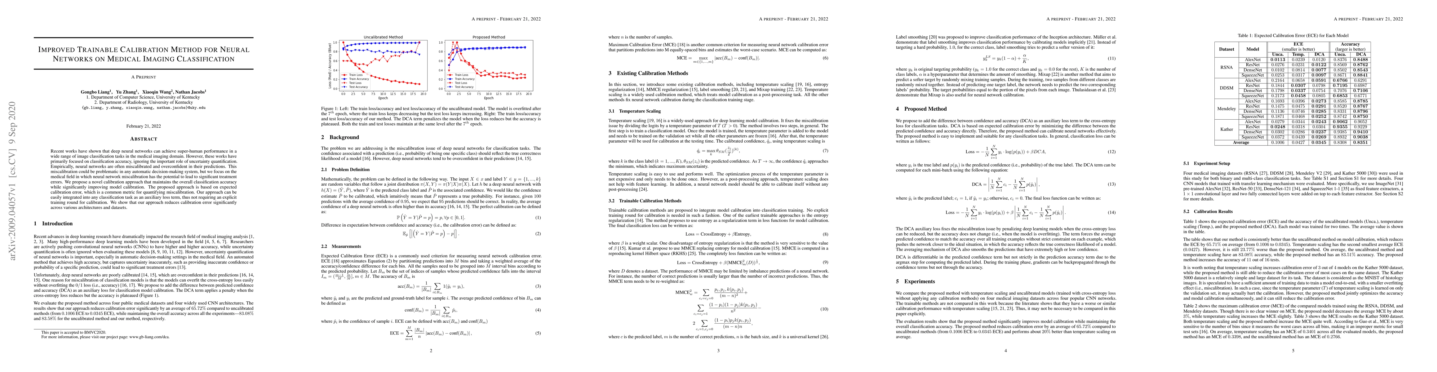
Recent works have shown that deep neural networks can achieve super-human performance in a wide range of image classification tasks in the medical imaging domain. However, these works have primarily...
Artifacts in imagery captured by remote sensing, such as clouds, snow, and shadows, present challenges for various tasks, including semantic segmentation and object detection. A primary challenge in...
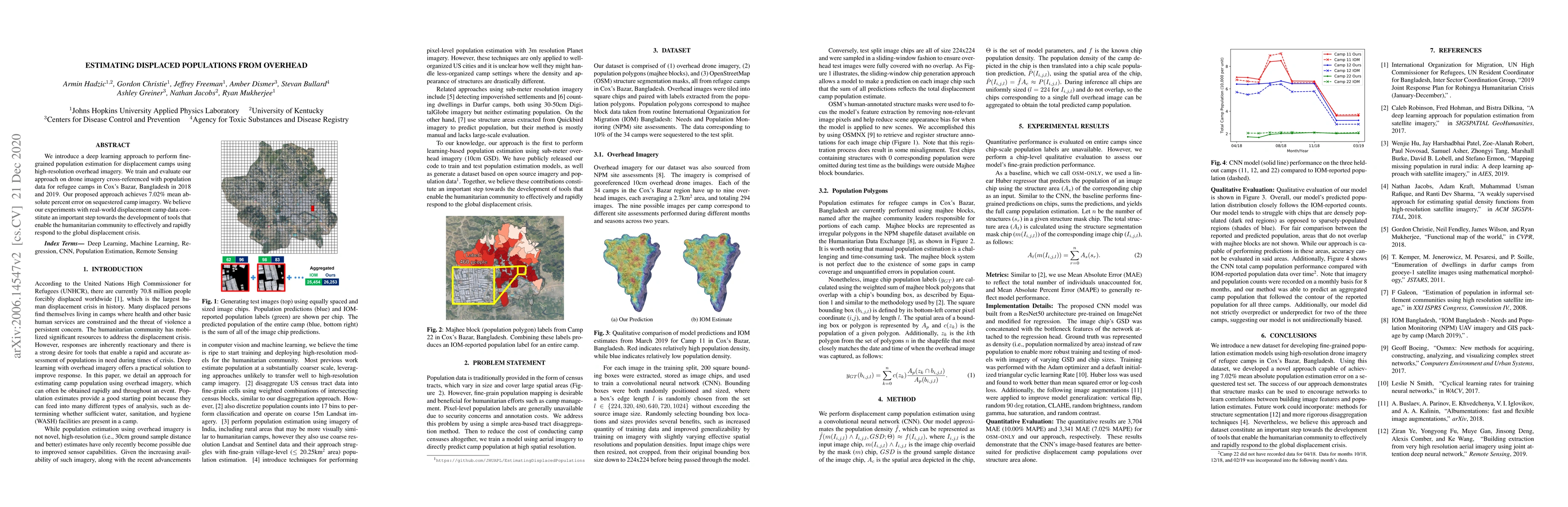
We introduce a deep learning approach to perform fine-grained population estimation for displacement camps using high-resolution overhead imagery. We train and evaluate our approach on drone imagery...
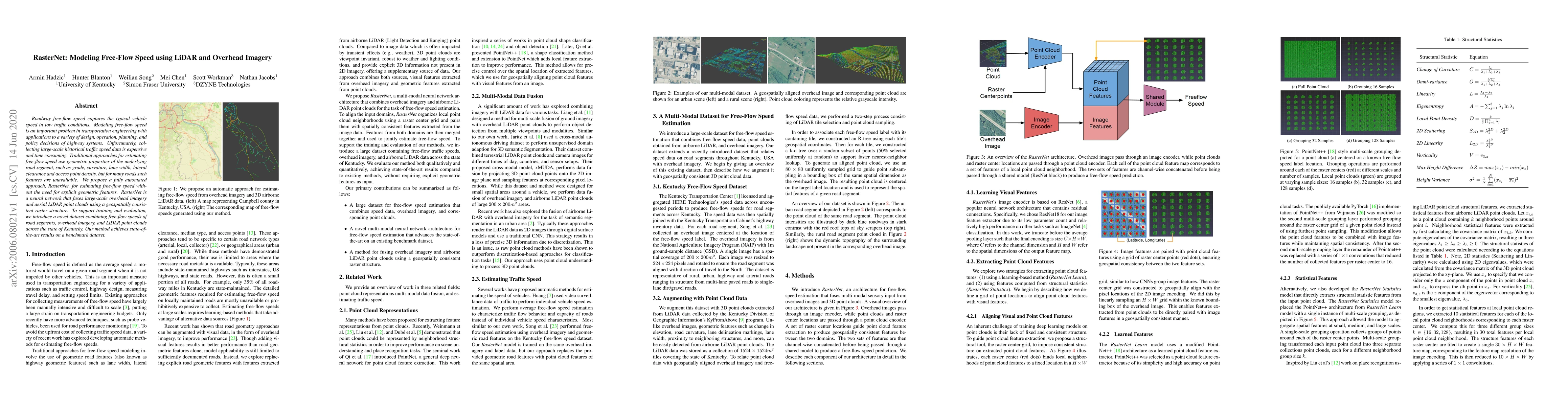
Roadway free-flow speed captures the typical vehicle speed in low traffic conditions. Modeling free-flow speed is an important problem in transportation engineering with applications to a variety of...

Generalization is one of the key challenges in the clinical validation and application of deep learning models to medical images. Studies have shown that such models trained on publicly available da...
Breast cancer is the malignant tumor that causes the highest number of cancer deaths in females. Digital mammograms (DM or 2D mammogram) and digital breast tomosynthesis (DBT or 3D mammogram) are th...
Automated methods for breast cancer detection have focused on 2D mammography and have largely ignored 3D digital breast tomosynthesis (DBT), which is frequently used in clinical practice. The two ke...
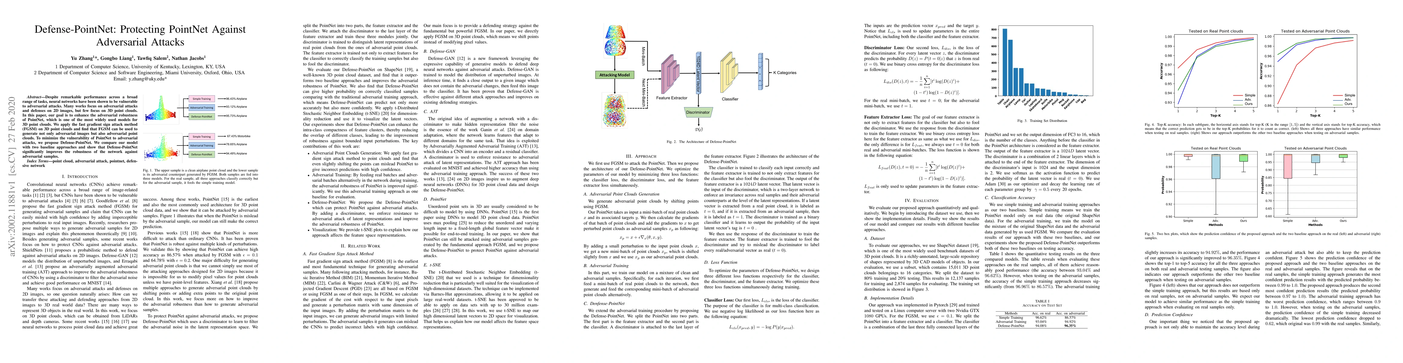
Despite remarkable performance across a broad range of tasks, neural networks have been shown to be vulnerable to adversarial attacks. Many works focus on adversarial attacks and defenses on 2D imag...
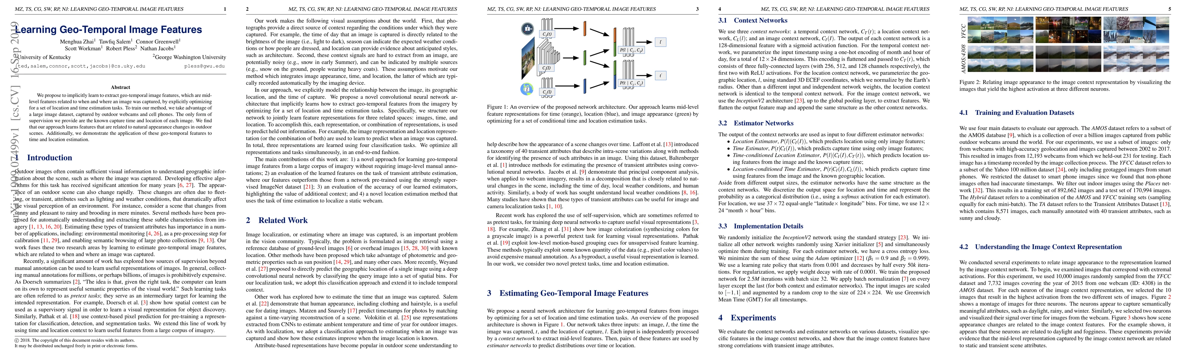
We propose to implicitly learn to extract geo-temporal image features, which are mid-level features related to when and where an image was captured, by explicitly optimizing for a set of location an...
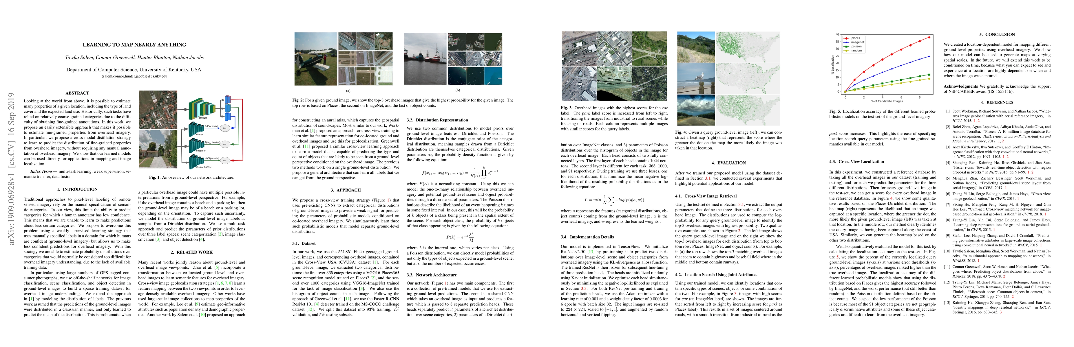
Looking at the world from above, it is possible to estimate many properties of a given location, including the type of land cover and the expected land use. Historically, such tasks have relied on r...
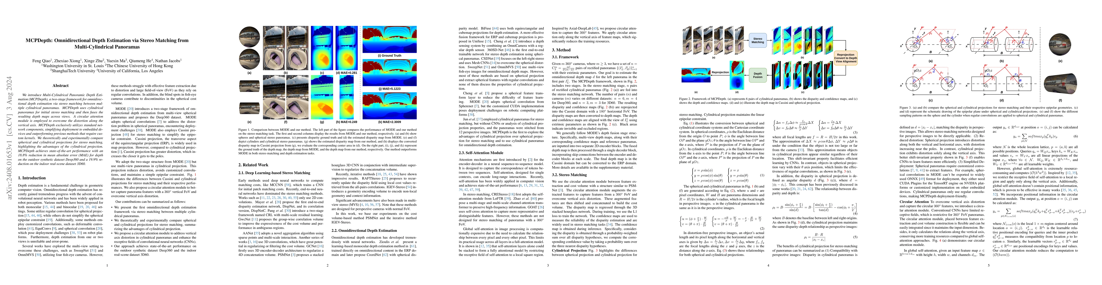
We introduce Multi-Cylindrical Panoramic Depth Estimation (MCPDepth), a two-stage framework for omnidirectional depth estimation via stereo matching between multiple cylindrical panoramas. MCPDepth us...
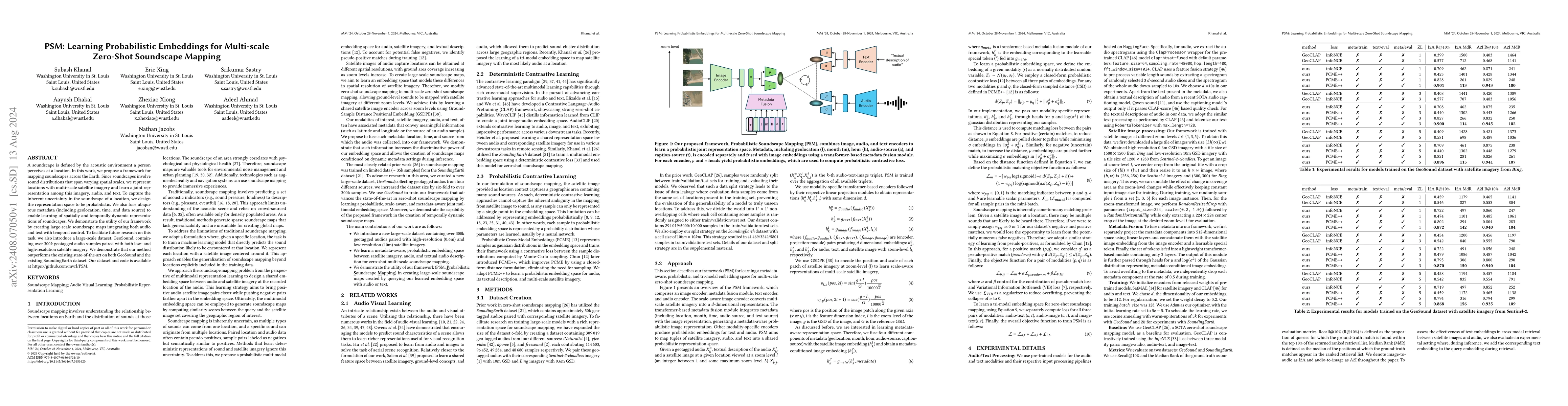
A soundscape is defined by the acoustic environment a person perceives at a location. In this work, we propose a framework for mapping soundscapes across the Earth. Since soundscapes involve sound dis...
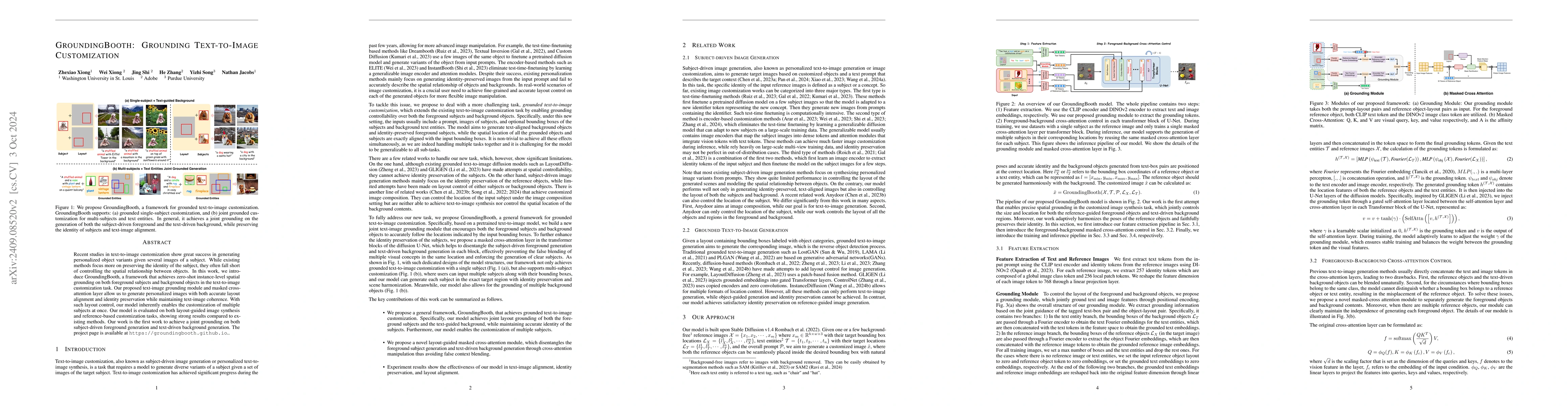
Recent studies in text-to-image customization show great success in generating personalized object variants given several images of a subject. While existing methods focus more on preserving the ident...
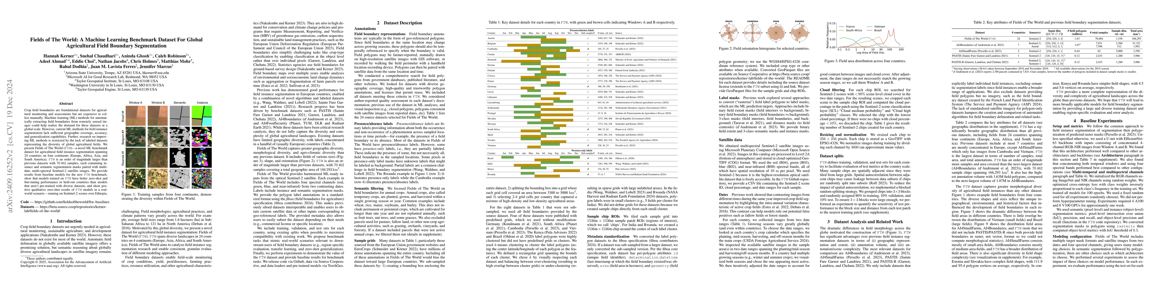
Crop field boundaries are foundational datasets for agricultural monitoring and assessments but are expensive to collect manually. Machine learning (ML) methods for automatically extracting field boun...
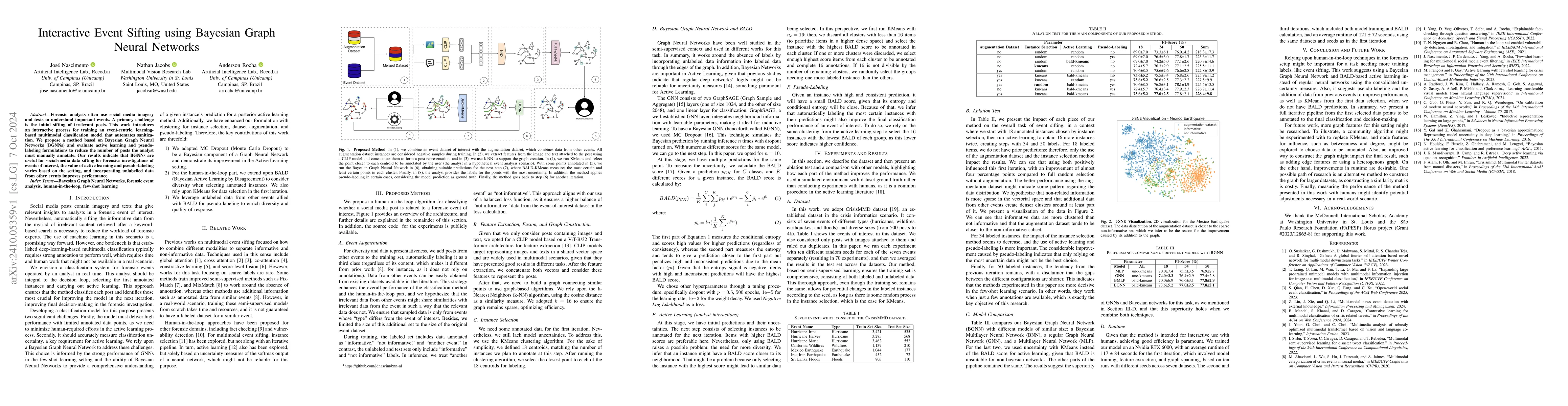
Forensic analysts often use social media imagery and texts to understand important events. A primary challenge is the initial sifting of irrelevant posts. This work introduces an interactive process f...
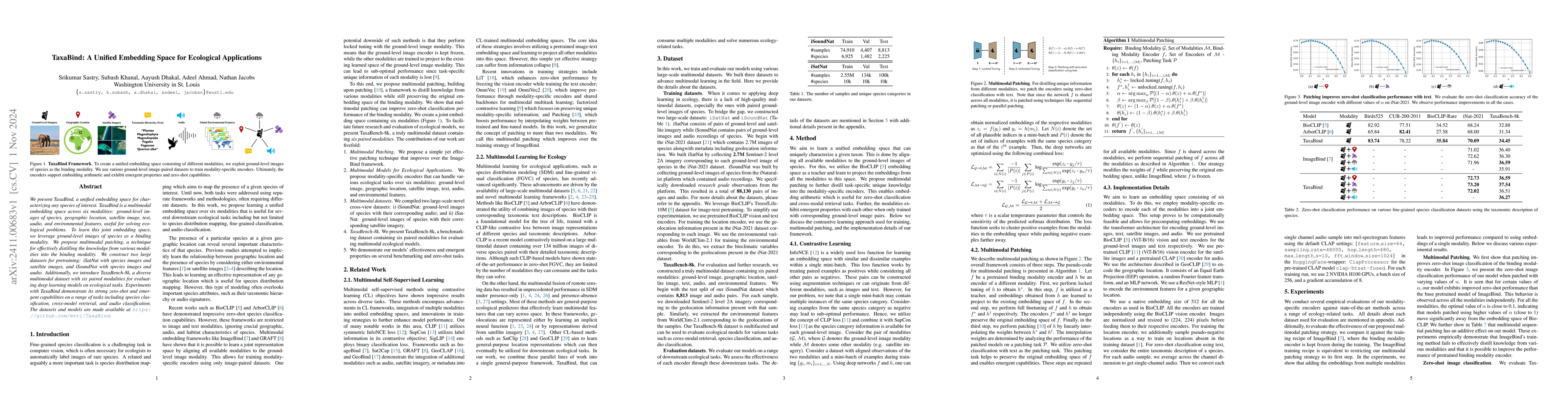
We present TaxaBind, a unified embedding space for characterizing any species of interest. TaxaBind is a multimodal embedding space across six modalities: ground-level images of species, geographic lo...
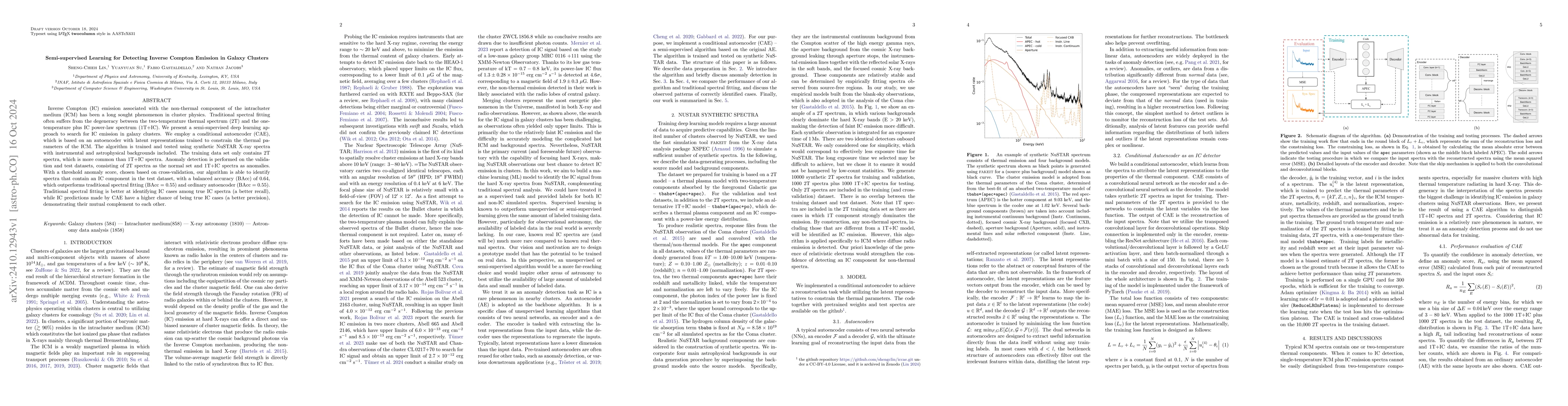
Inverse Compton (IC) emission associated with the non-thermal component of the intracluster medium (ICM) has been a long sought phenomenon in cluster physics. Traditional spectral fitting often suffer...
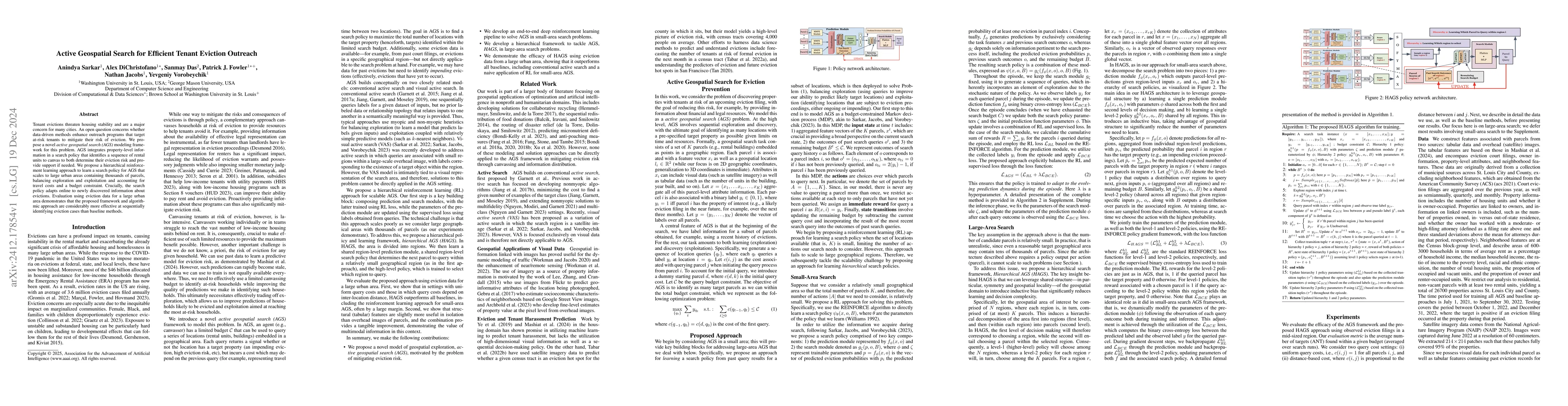
Tenant evictions threaten housing stability and are a major concern for many cities. An open question concerns whether data-driven methods enhance outreach programs that target at-risk tenants to miti...
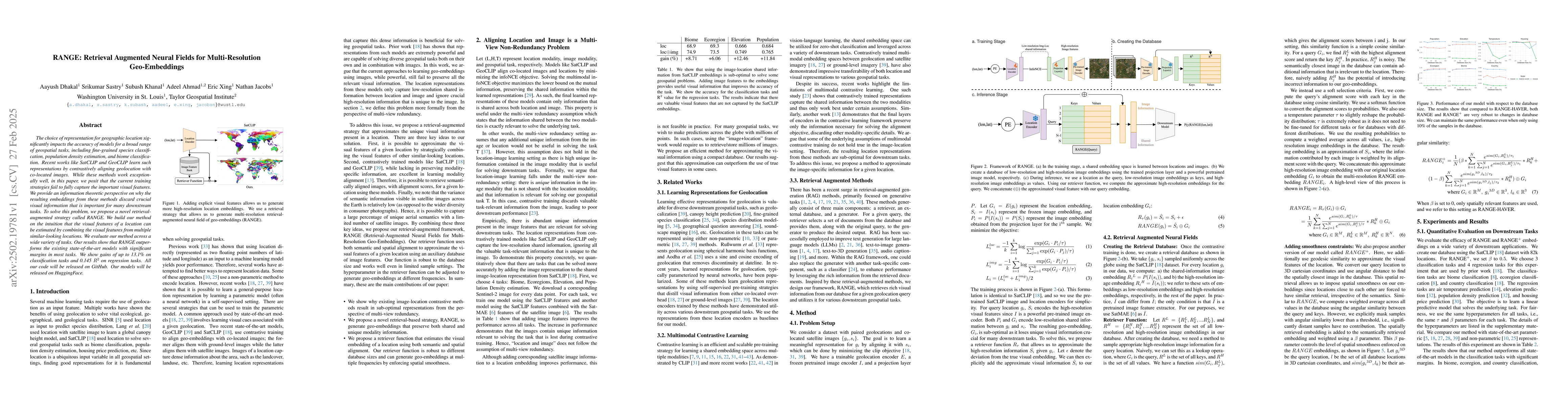
The choice of representation for geographic location significantly impacts the accuracy of models for a broad range of geospatial tasks, including fine-grained species classification, population densi...
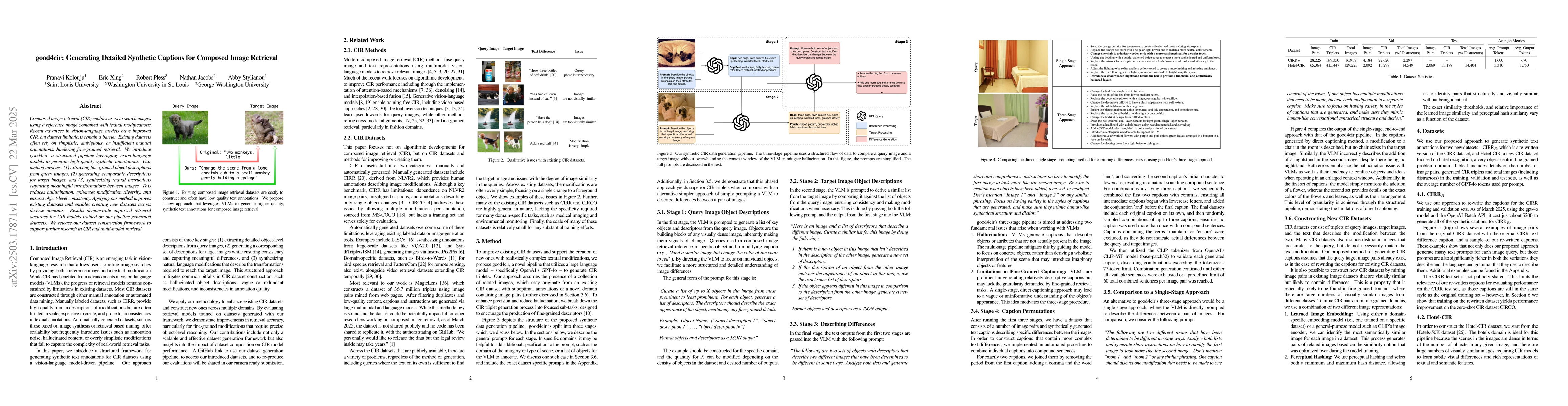
Composed image retrieval (CIR) enables users to search images using a reference image combined with textual modifications. Recent advances in vision-language models have improved CIR, but dataset limi...
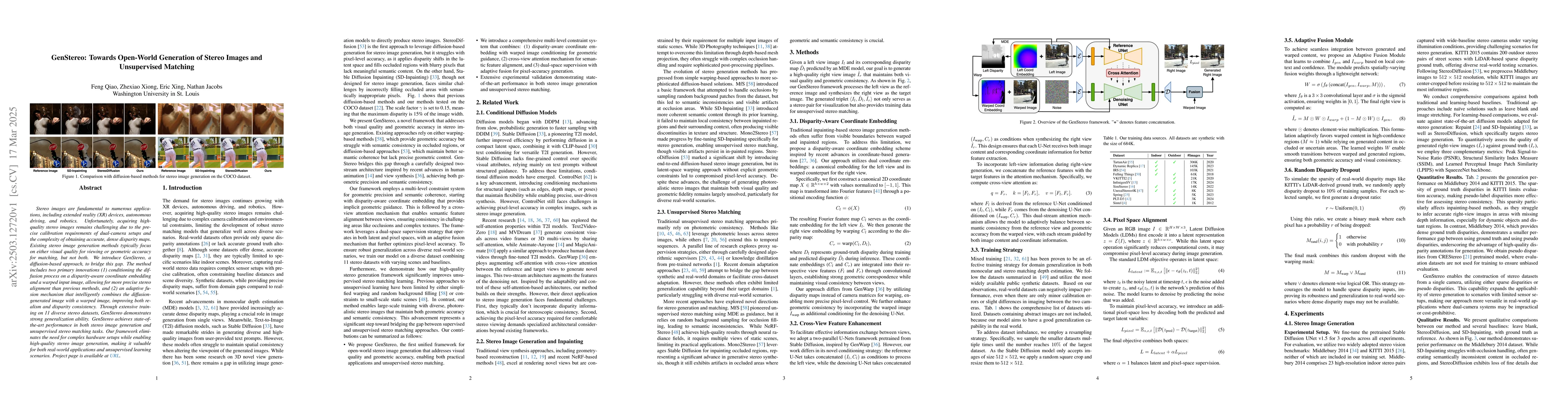
Stereo images are fundamental to numerous applications, including extended reality (XR) devices, autonomous driving, and robotics. Unfortunately, acquiring high-quality stereo images remains challengi...
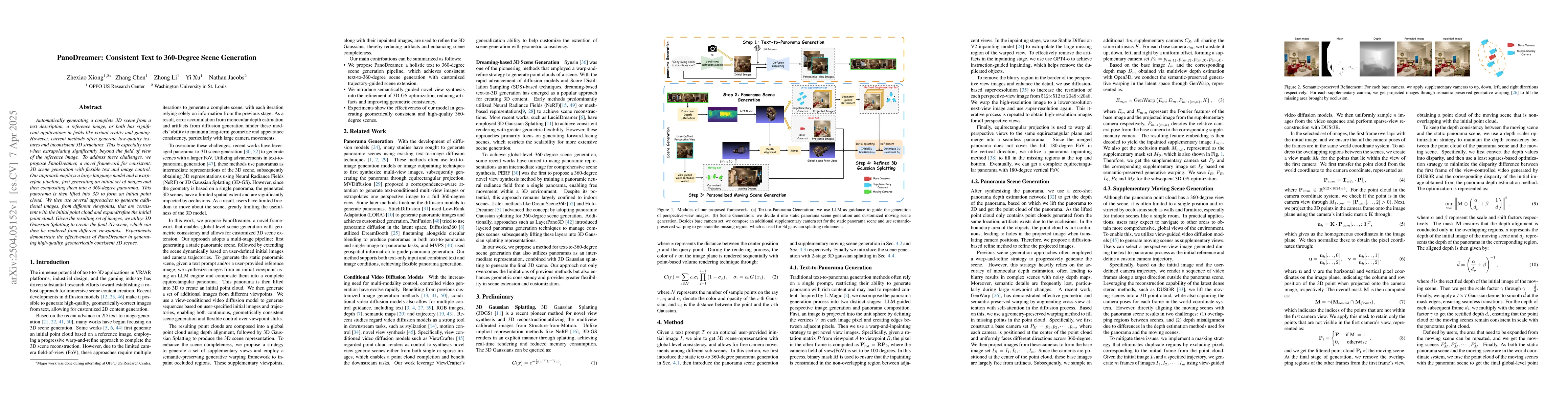
Automatically generating a complete 3D scene from a text description, a reference image, or both has significant applications in fields like virtual reality and gaming. However, current methods often ...
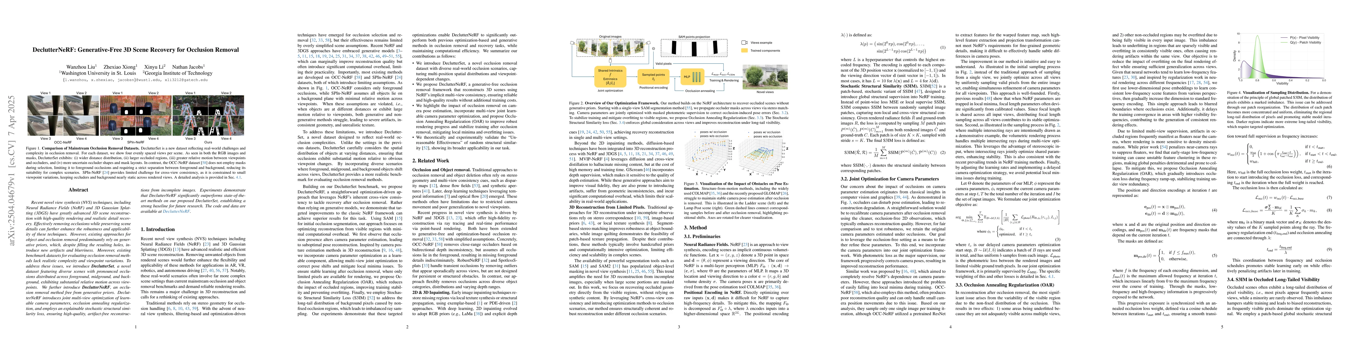
Recent novel view synthesis (NVS) techniques, including Neural Radiance Fields (NeRF) and 3D Gaussian Splatting (3DGS) have greatly advanced 3D scene reconstruction with high-quality rendering and rea...
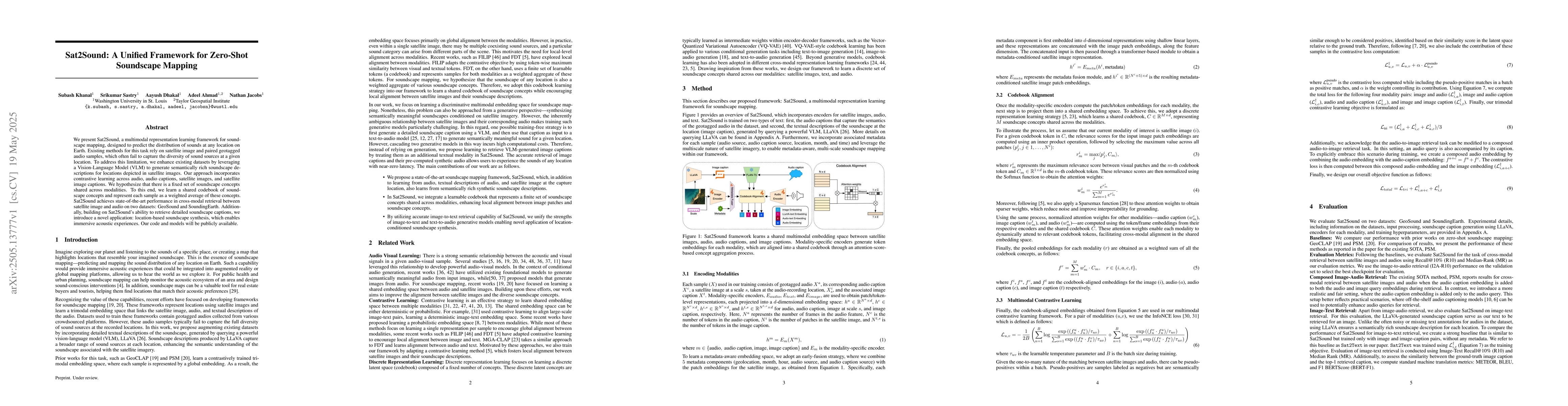
We present Sat2Sound, a multimodal representation learning framework for soundscape mapping, designed to predict the distribution of sounds at any location on Earth. Existing methods for this task rel...
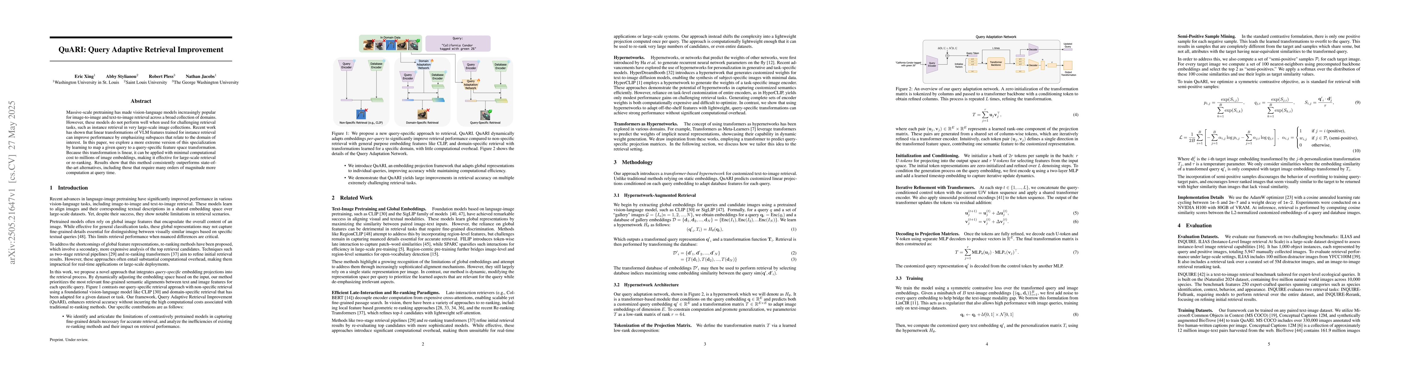
Massive-scale pretraining has made vision-language models increasingly popular for image-to-image and text-to-image retrieval across a broad collection of domains. However, these models do not perform...
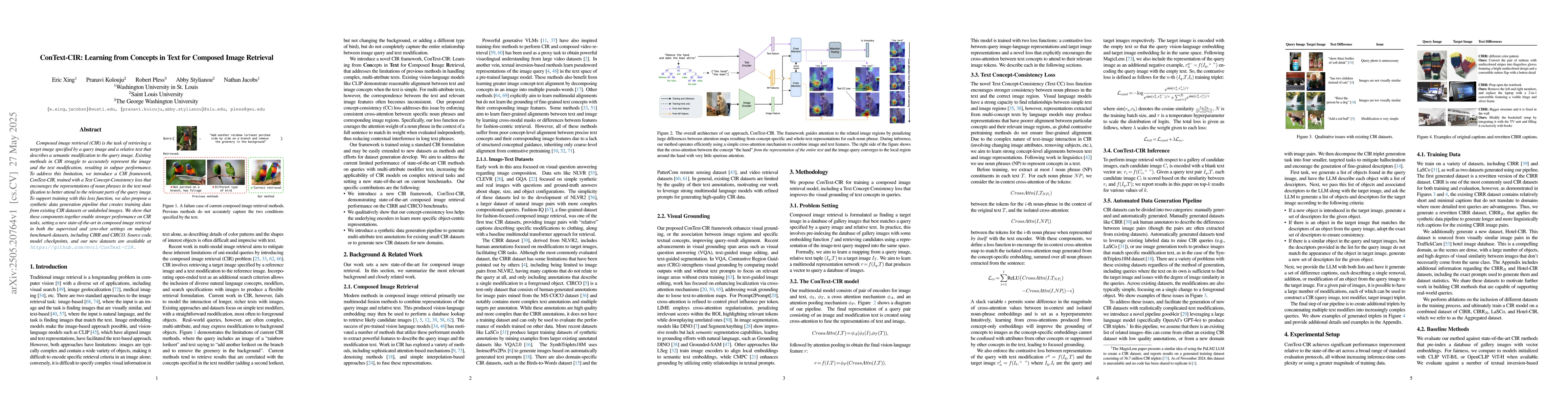
Composed image retrieval (CIR) is the task of retrieving a target image specified by a query image and a relative text that describes a semantic modification to the query image. Existing methods in CI...
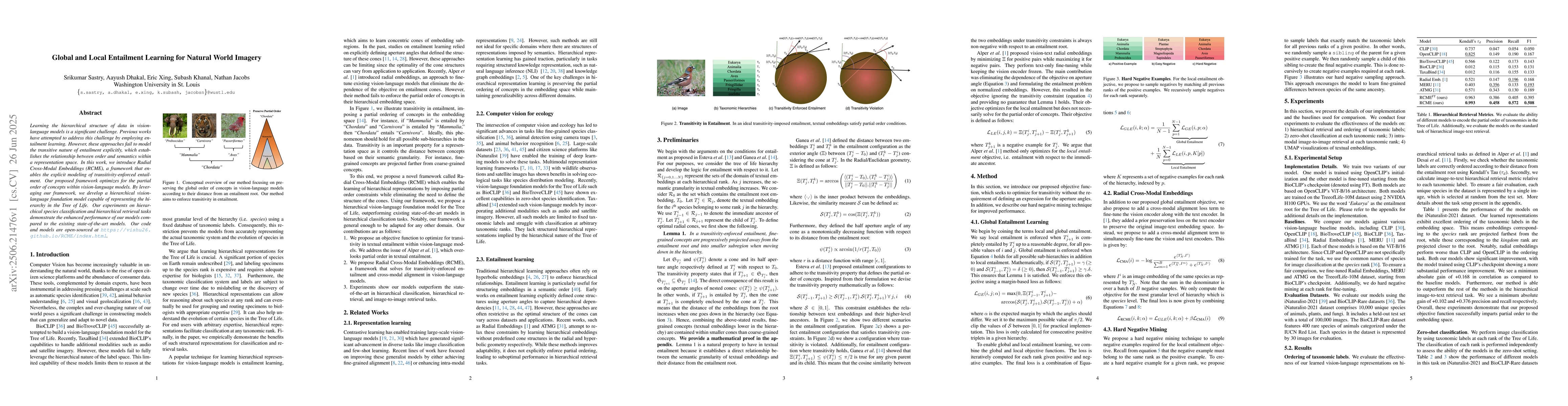
Learning the hierarchical structure of data in vision-language models is a significant challenge. Previous works have attempted to address this challenge by employing entailment learning. However, the...
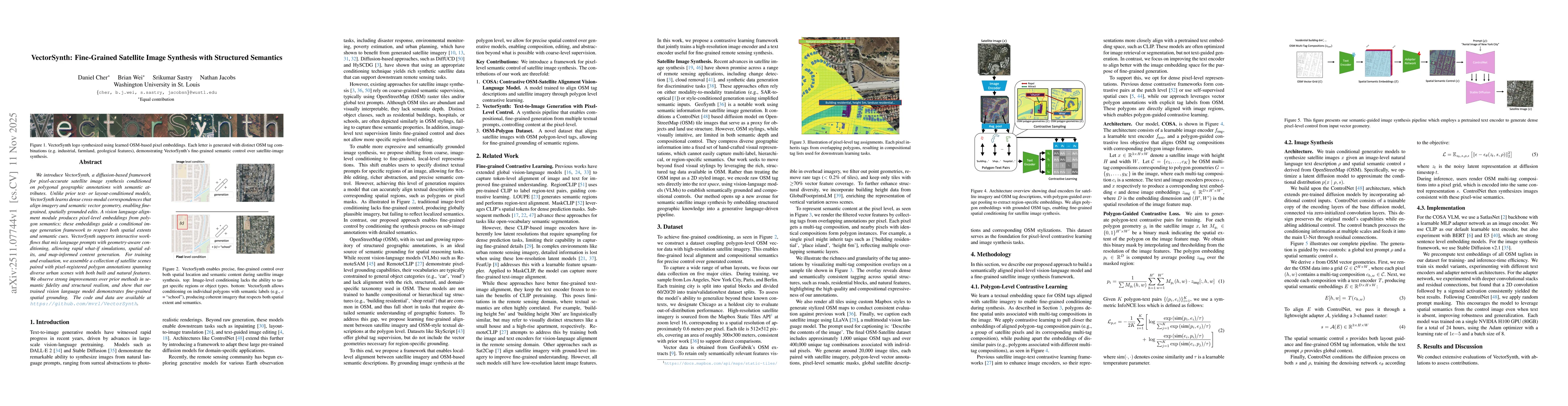
We introduce VectorSynth, a diffusion-based framework for pixel-accurate satellite image synthesis conditioned on polygonal geographic annotations with semantic attributes. Unlike prior text- or layou...
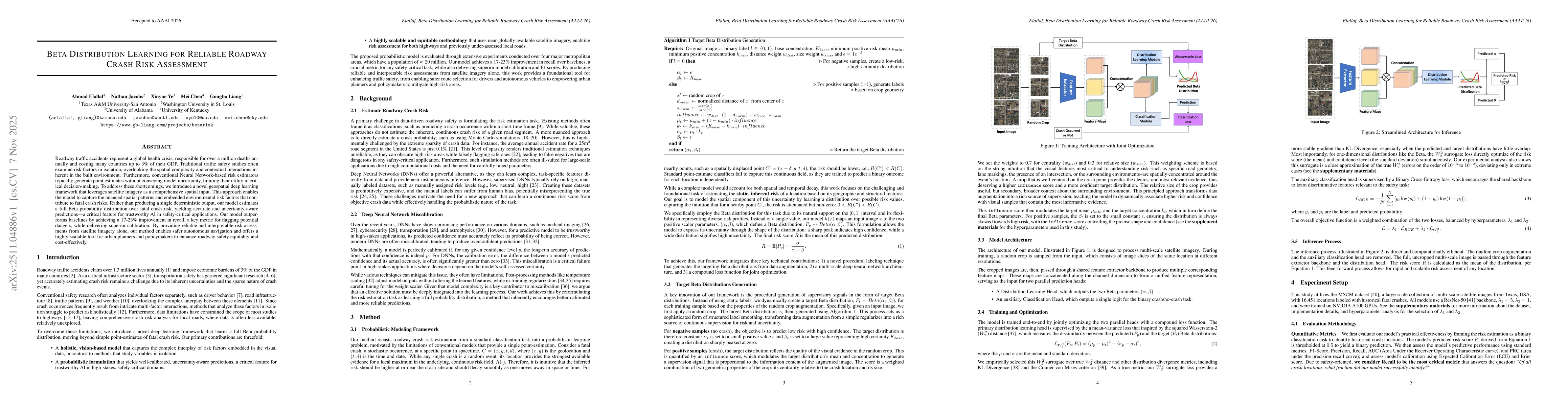
Roadway traffic accidents represent a global health crisis, responsible for over a million deaths annually and costing many countries up to 3% of their GDP. Traditional traffic safety studies often ex...
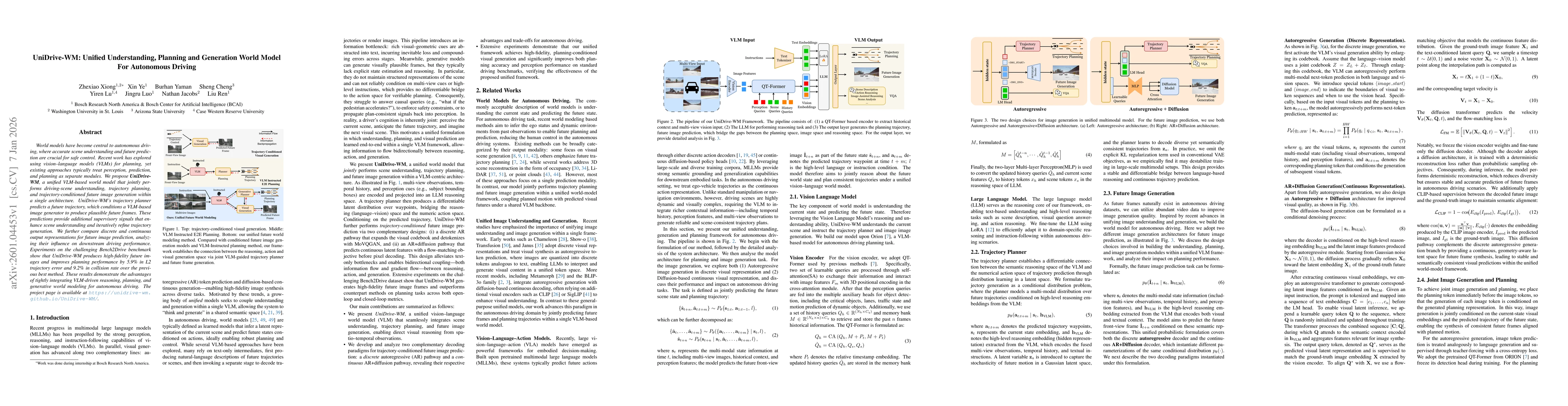
World models have become central to autonomous driving, where accurate scene understanding and future prediction are crucial for safe control. Recent work has explored using vision-language models (VL...
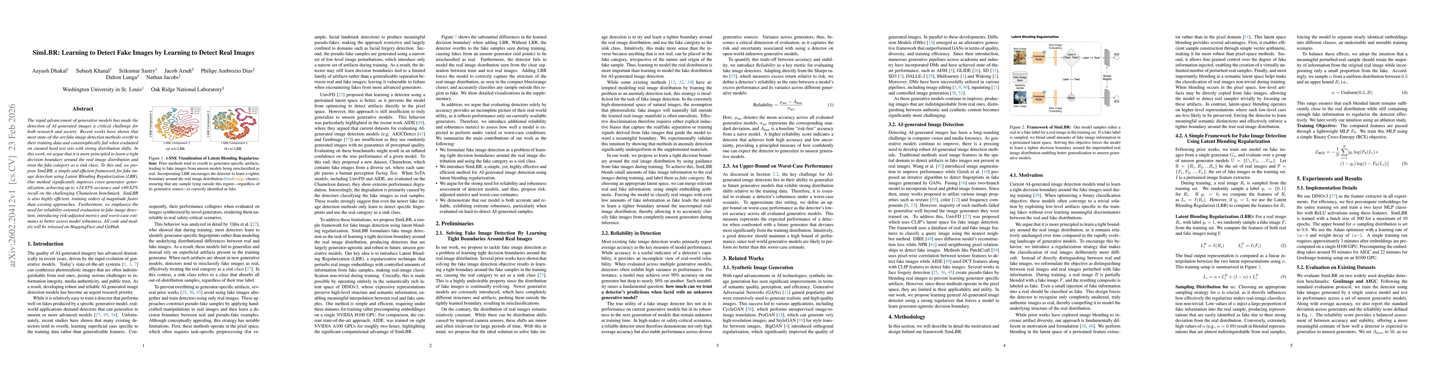
The rapid advancement of generative models has made the detection of AI-generated images a critical challenge for both research and society. Recent works have shown that most state-of-the-art fake ima...
We introduce GeoDiT, a diffusion transformer designed for text-to-satellite image generation with point-based control. Existing controlled satellite image generative models often require pixel-level m...
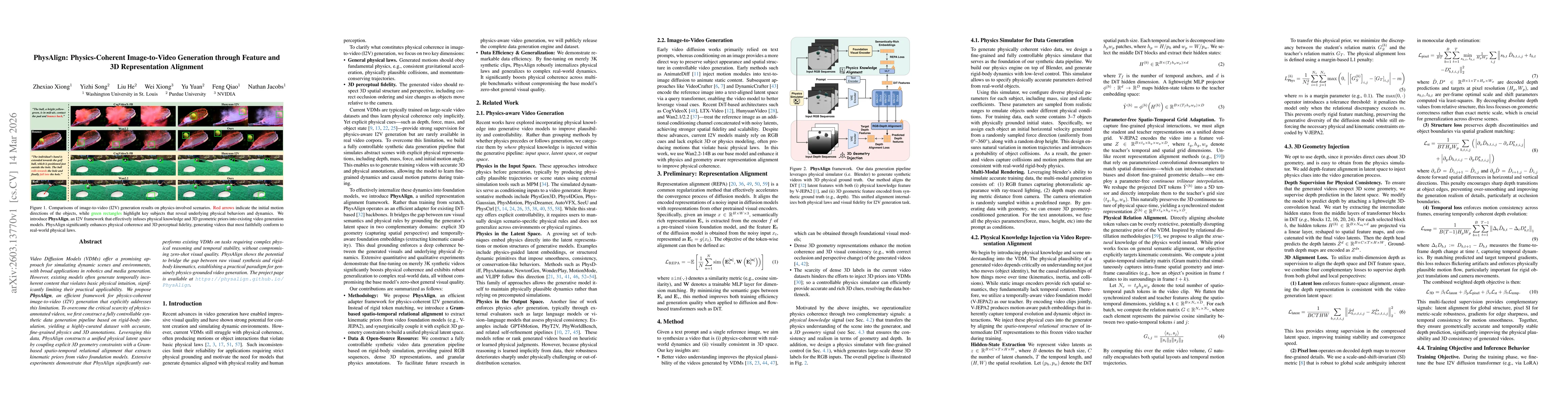
Video Diffusion Models (VDMs) offer a promising approach for simulating dynamic scenes and environments, with broad applications in robotics and media generation. However, existing models often genera...
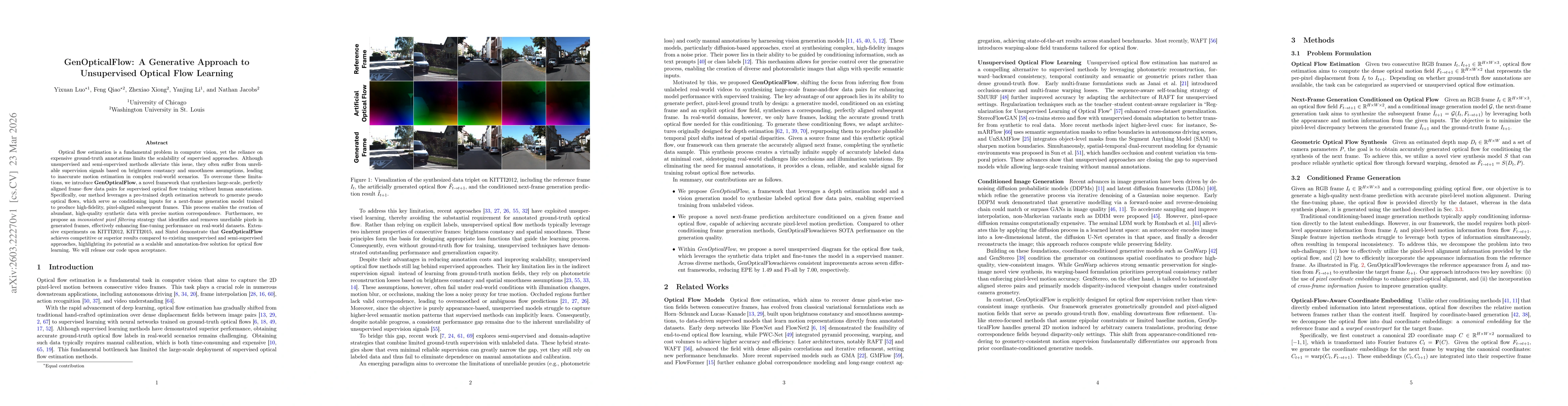
Optical flow estimation is a fundamental problem in computer vision, yet the reliance on expensive ground-truth annotations limits the scalability of supervised approaches. Although unsupervised and s...
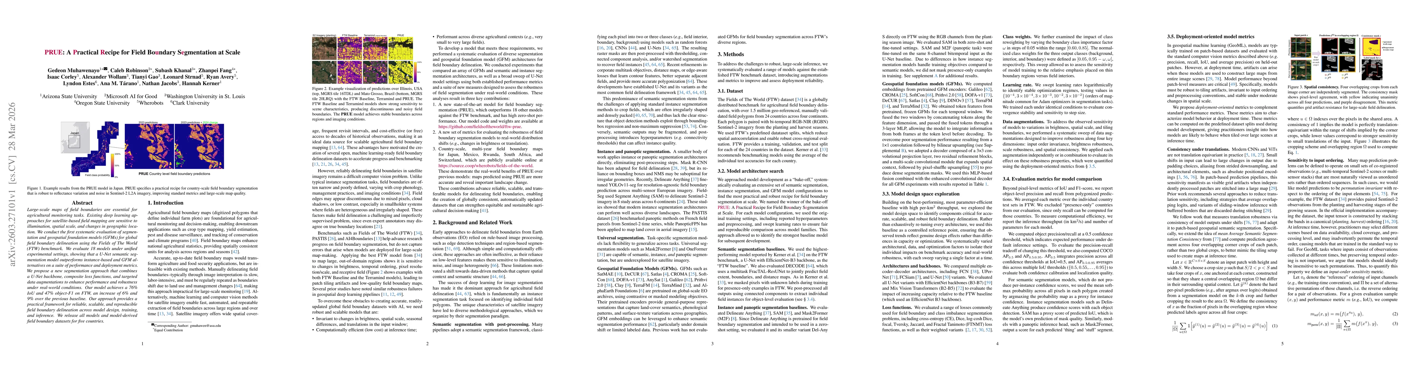
Large-scale maps of field boundaries are essential for agricultural monitoring tasks. Existing deep learning approaches for satellite-based field mapping are sensitive to illumination, spatial scale, ...
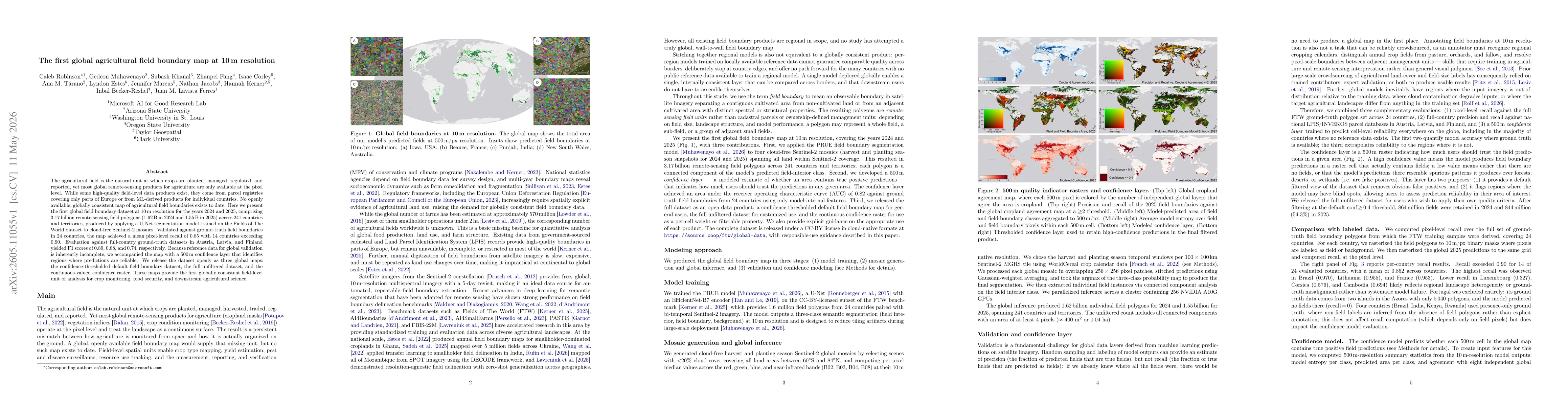
The agricultural field is the natural unit at which crops are planted, managed, regulated, and reported, yet most global remote-sensing products for agriculture are only available at the pixel level. ...
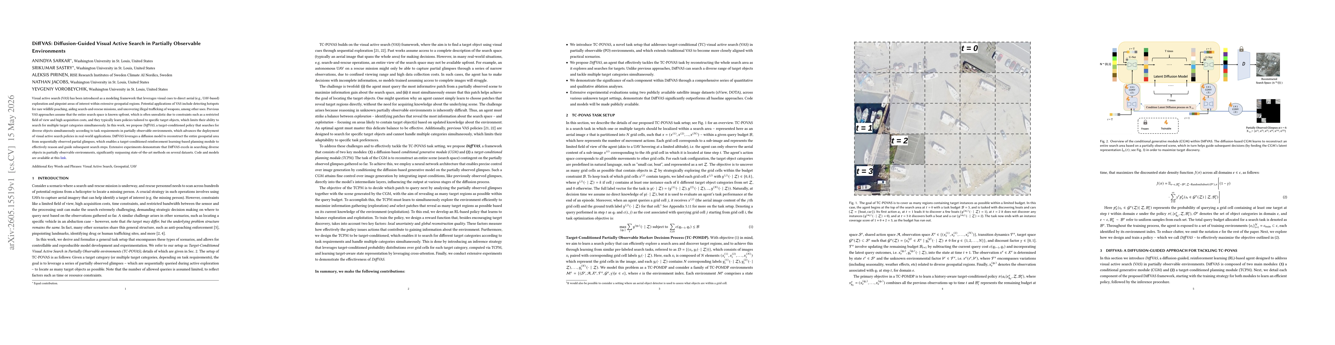
Visual active search (VAS) has been introduced as a modeling framework that leverages visual cues to direct aerial (e.g., UAV-based) exploration and pinpoint areas of interest within extensive geospat...
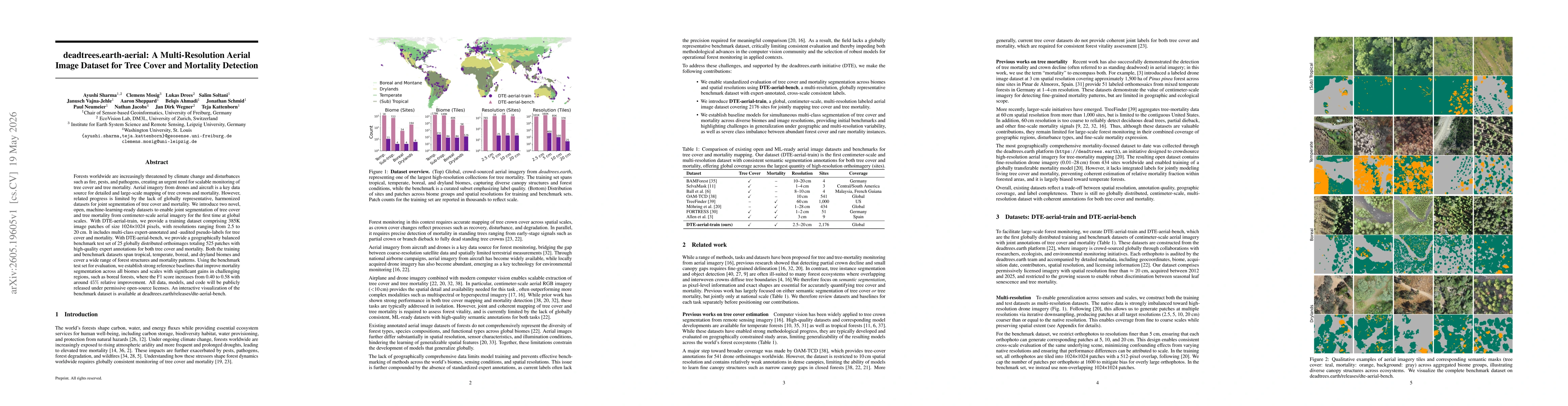
Forests worldwide are increasingly threatened by climate change and disturbances such as fire, pests, and pathogens, creating an urgent need for scalable monitoring of tree cover and tree mortality. A...
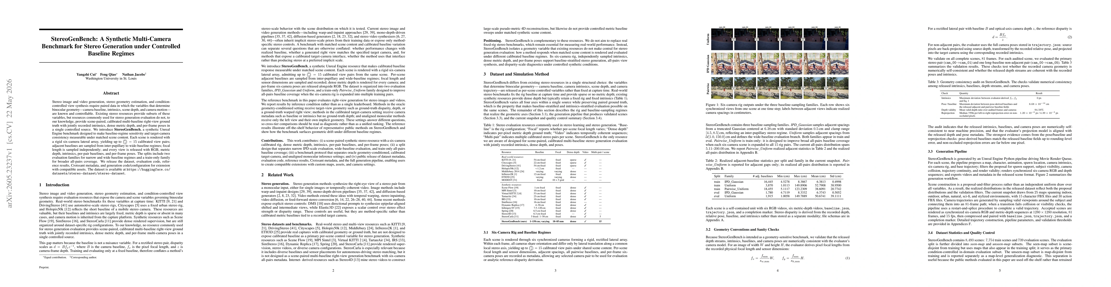
Stereo image and video generation, stereo geometry estimation, and condition-controlled view synthesis require paired data in which the variables that determine binocular geometry -- camera baseline, ...
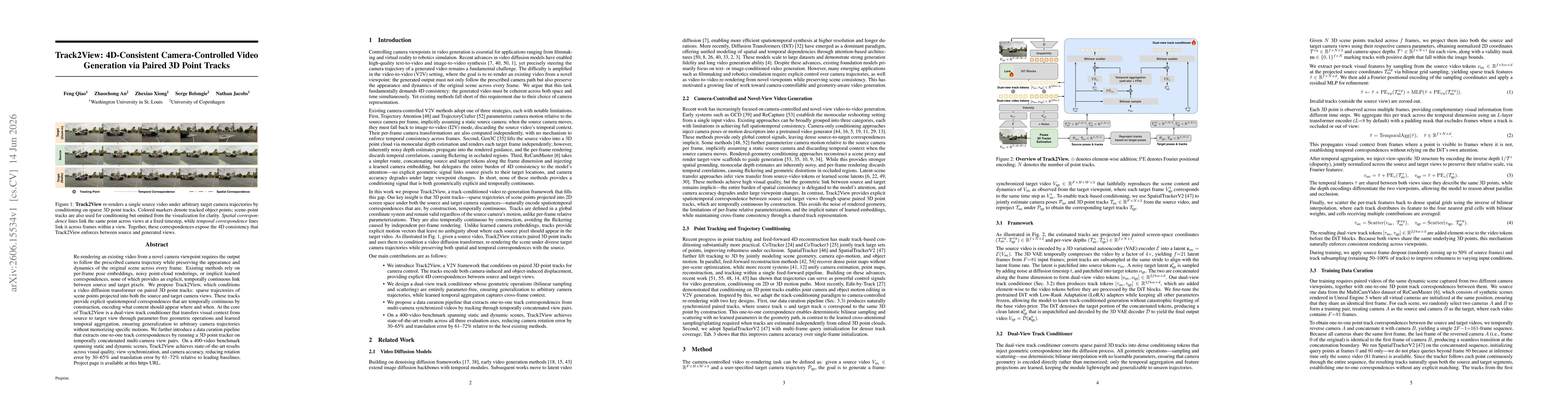
Re-rendering an existing video from a novel camera viewpoint requires the output to follow the prescribed camera trajectory while preserving the appearance and dynamics of the original scene across ev...
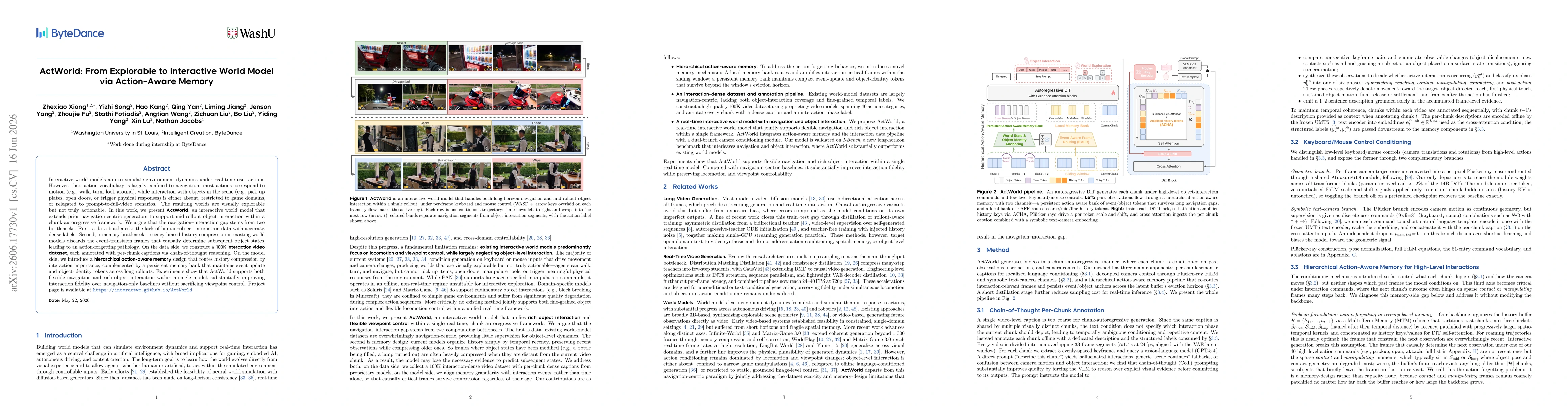
Interactive world models aim to simulate environment dynamics under real-time user actions. However, their action vocabulary is largely confined to navigation: most actions correspond to motion (e.g.,...

Interactive world models aim to simulate environment dynamics under real-time user actions. However, their action vocabulary is largely confined to navigation: most actions correspond to motion (e.g.,...
Multimodal contrastive learning has enabled zero-shot visual classification by aligning images with textual categories. However, in hierarchically structured label spaces, existing methods often produ...