GEOBIND: Binding Text, Image, and Audio through Satellite Images
Publication
Metrics
AI Quick Summary
GeoBind is a deep-learning model that uses satellite images to infer relationships between text, image, and audio data, creating a joint embedding space. It aligns multiple modalities through satellite imagery without requiring a single complex dataset, showcasing versatility in multi-modal reasoning.
Paper Preview
Abstract
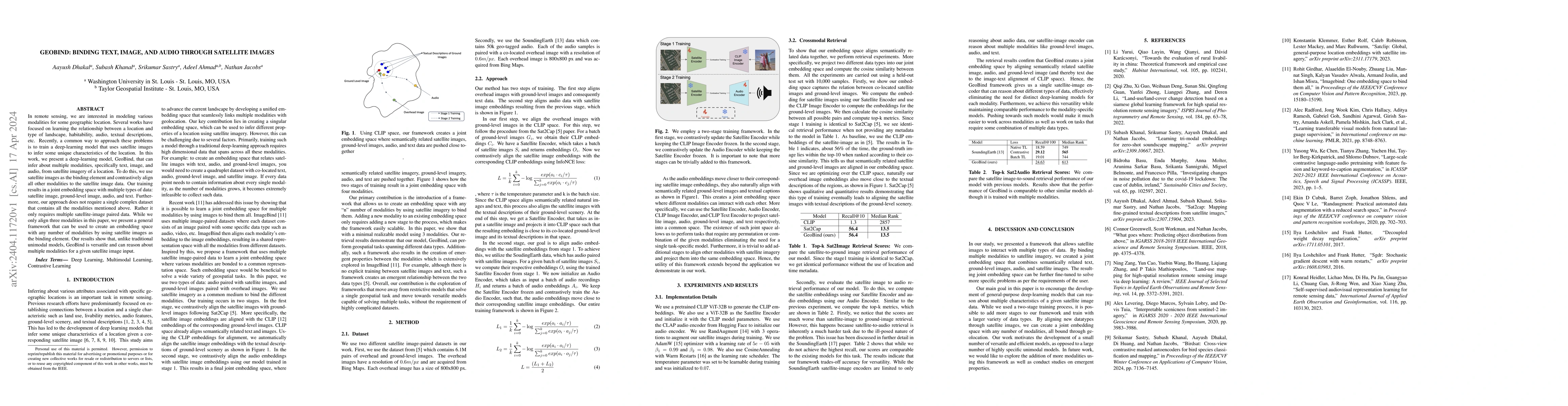
In remote sensing, we are interested in modeling various modalities for some geographic location. Several works have focused on learning the relationship between a location and type of landscape, habitability, audio, textual descriptions, etc. Recently, a common way to approach these problems is to train a deep-learning model that uses satellite images to infer some unique characteristics of the location. In this work, we present a deep-learning model, GeoBind, that can infer about multiple modalities, specifically text, image, and audio, from satellite imagery of a location. To do this, we use satellite images as the binding element and contrastively align all other modalities to the satellite image data. Our training results in a joint embedding space with multiple types of data: satellite image, ground-level image, audio, and text. Furthermore, our approach does not require a single complex dataset that contains all the modalities mentioned above. Rather it only requires multiple satellite-image paired data. While we only align three modalities in this paper, we present a general framework that can be used to create an embedding space with any number of modalities by using satellite images as the binding element. Our results show that, unlike traditional unimodal models, GeoBind is versatile and can reason about multiple modalities for a given satellite image input.
AI Key Findings
Get AI-generated insights about this paper's methodology, results, significance, and more — seven facets brought into focus.
Impact
Paper Details
Authors
PDF Preview
Key Terms
Citation Network
Current paper (gray), citations (green), references (blue)
Display is limited for performance on very large graphs.
Discussion 0