Academic Profile
Statistics
Similar Authors
Papers on arXiv
Satellite remote sensing serves as a crucial means to acquire cloud physical parameters. However, existing official cloud products derived from the advanced geostationary radiation imager (AGRI) onb...
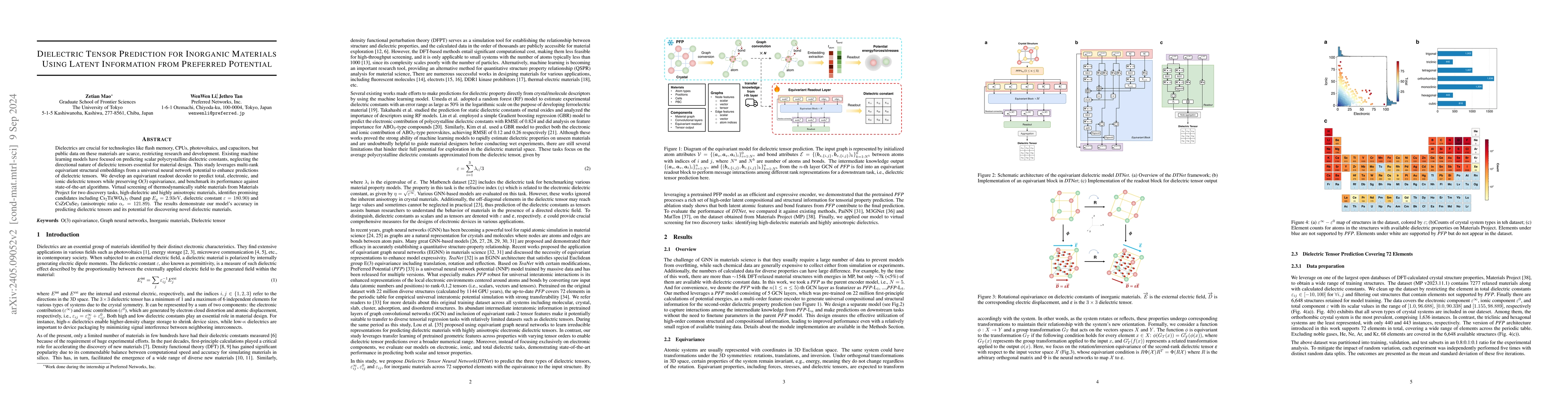
Dielectrics are materials with widespread applications in flash memory, central processing units, photovoltaics, capacitors, etc. However, the availability of public dielectric data remains limited,...
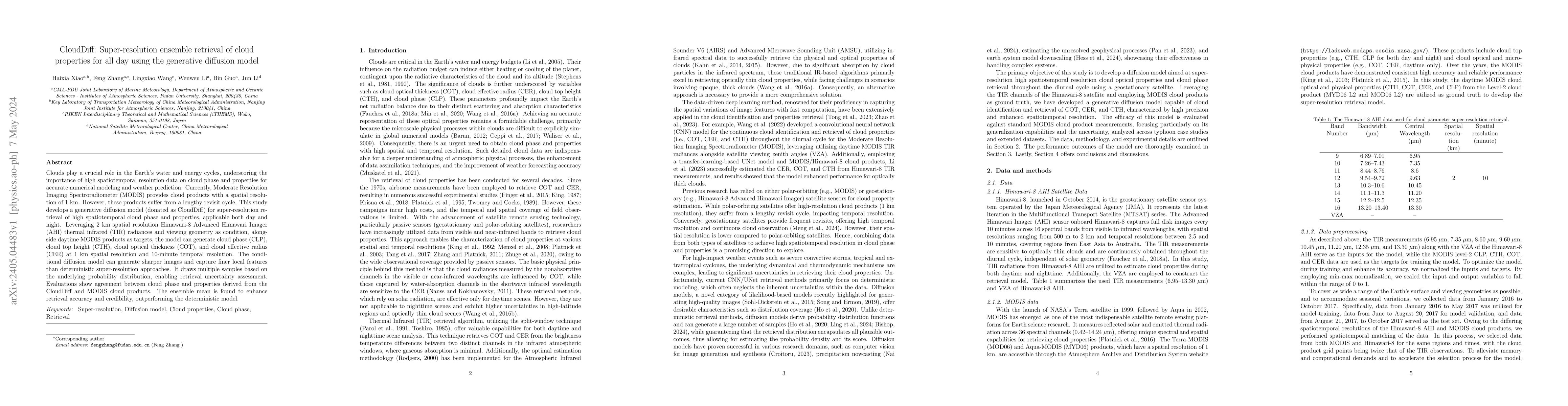
Clouds play a crucial role in the Earth's water and energy cycles, underscoring the importance of high spatiotemporal resolution data on cloud phase and properties for accurate numerical modeling an...
Flood inundation mapping is a critical task for responding to the increasing risk of flooding linked to global warming. Significant advancements of deep learning in recent years have triggered its e...
In this paper, we study pointwise finite-dimensional (p.f.d.) $2$-parameter persistence modules where each module admits a finite convex isotopy subdivision. We show that a p.f.d. $2$-parameter pers...
The polarization characteristics of atmospheric scattering are important and should not be ignored in radiative transfer simulations. In this study, a new vector radiative transfer model called the ...
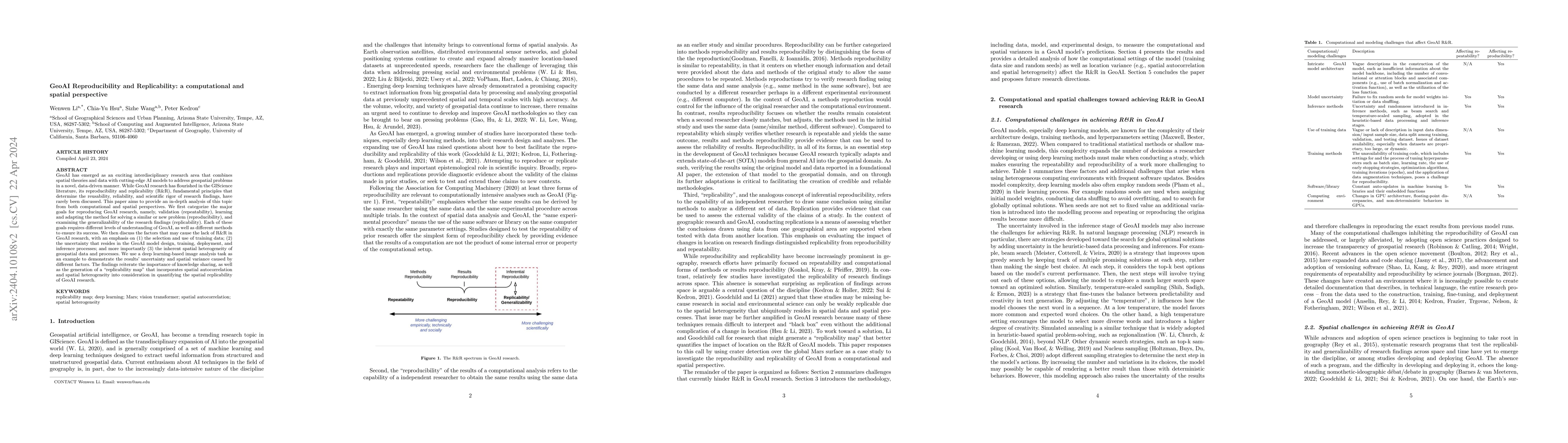
GeoAI has emerged as an exciting interdisciplinary research area that combines spatial theories and data with cutting-edge AI models to address geospatial problems in a novel, data-driven manner. Wh...
Big earth science data offers the scientific community great opportunities. Many more studies at large-scales, over long-terms and at high resolution can now be conducted using the rich information ...
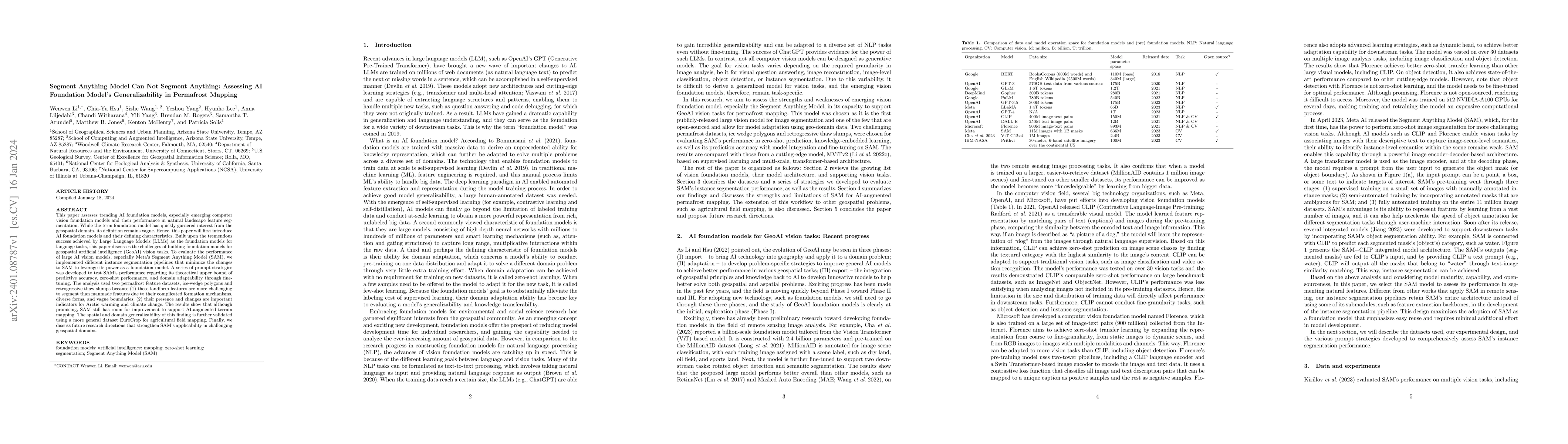
This paper assesses trending AI foundation models, especially emerging computer vision foundation models and their performance in natural landscape feature segmentation. While the term foundation mo...
GeoAI, or geospatial artificial intelligence, is an exciting new area that leverages artificial intelligence (AI), geospatial big data, and massive computing power to solve problems with high automa...
Multiparameter persistence modules come up naturally in topological data analysis and topological robotics. Given a metric graph $(X,\delta)$, the second configuration space of $(X,\delta)$ with pro...
Computed Tomography (CT) is commonly used to image acute ischemic stroke (AIS) patients, but its interpretation by radiologists is time-consuming and subject to inter-observer variability. Deep lear...
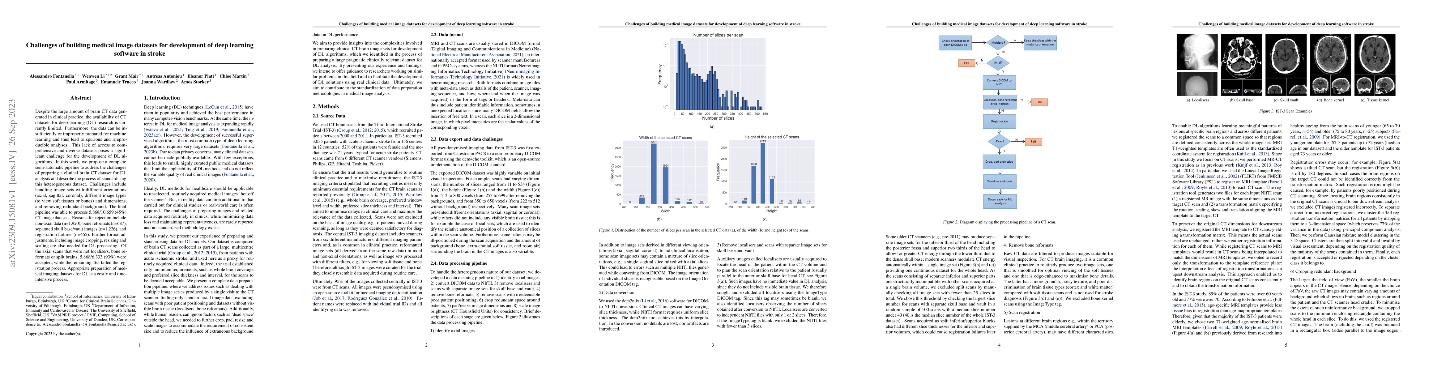
Despite the large amount of brain CT data generated in clinical practice, the availability of CT datasets for deep learning (DL) research is currently limited. Furthermore, the data can be insuffici...
Vision foundation models are a new frontier in Geospatial Artificial Intelligence (GeoAI), an interdisciplinary research area that applies and extends AI for geospatial problem solving and geographi...
We demonstrate photon-counting single-pixel imaging in the ultraviolet region. Toward this target, we develop a high-performance compact single-photon detector based on a 4H-SiC single-photon avalan...
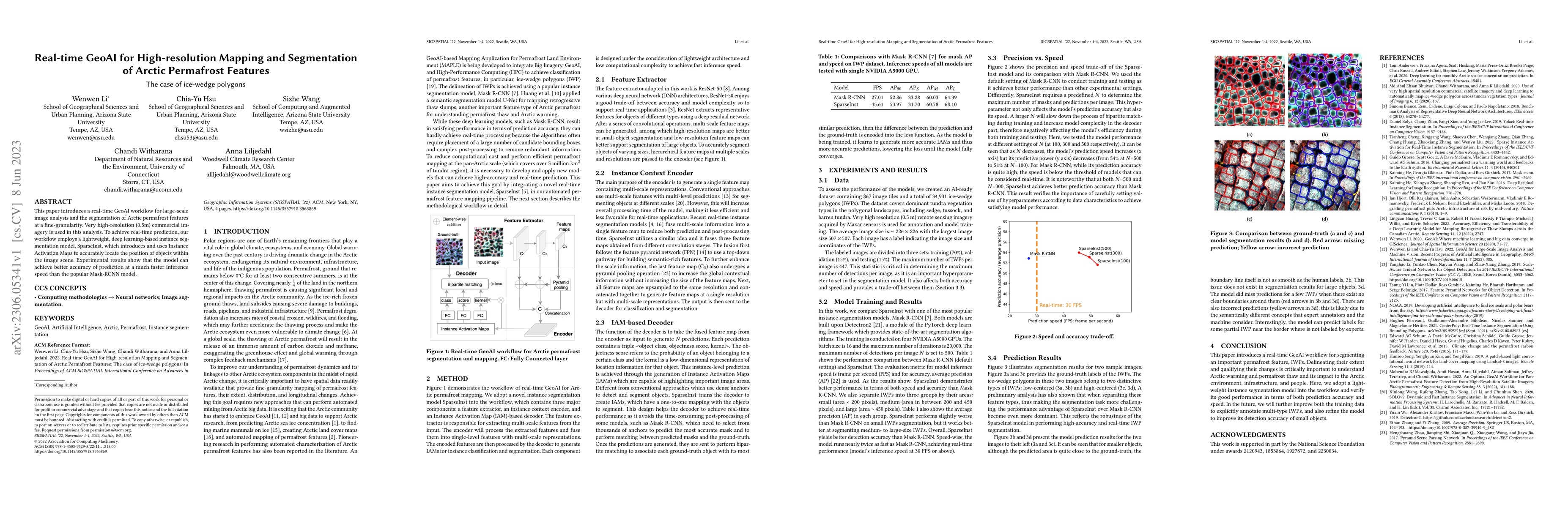
This paper introduces a real-time GeoAI workflow for large-scale image analysis and the segmentation of Arctic permafrost features at a fine-granularity. Very high-resolution (0.5m) commercial image...
Initiated by the University Consortium of Geographic Information Science (UCGIS), GIS&T Body of Knowledge (BoK) is a community-driven endeavor to define, develop, and document geospatial topics rela...
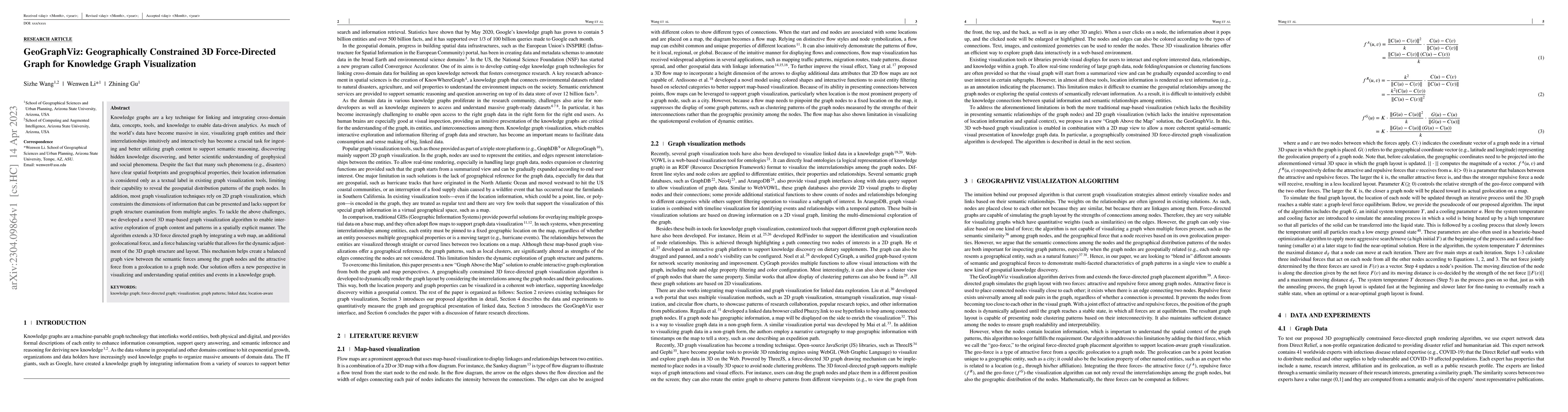
Knowledge graphs are a key technique for linking and integrating cross-domain data, concepts, tools, and knowledge to enable data-driven analytics. As much of the worlds data have become massive in ...
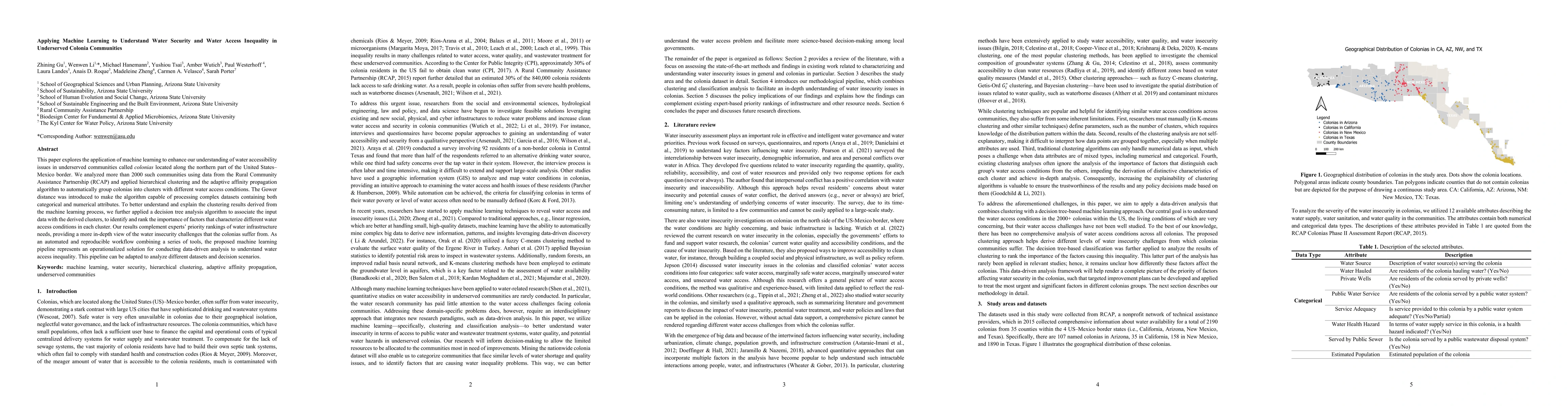
This paper explores the application of machine learning to enhance our understanding of water accessibility issues in underserved communities called Colonias located along the northern part of the U...
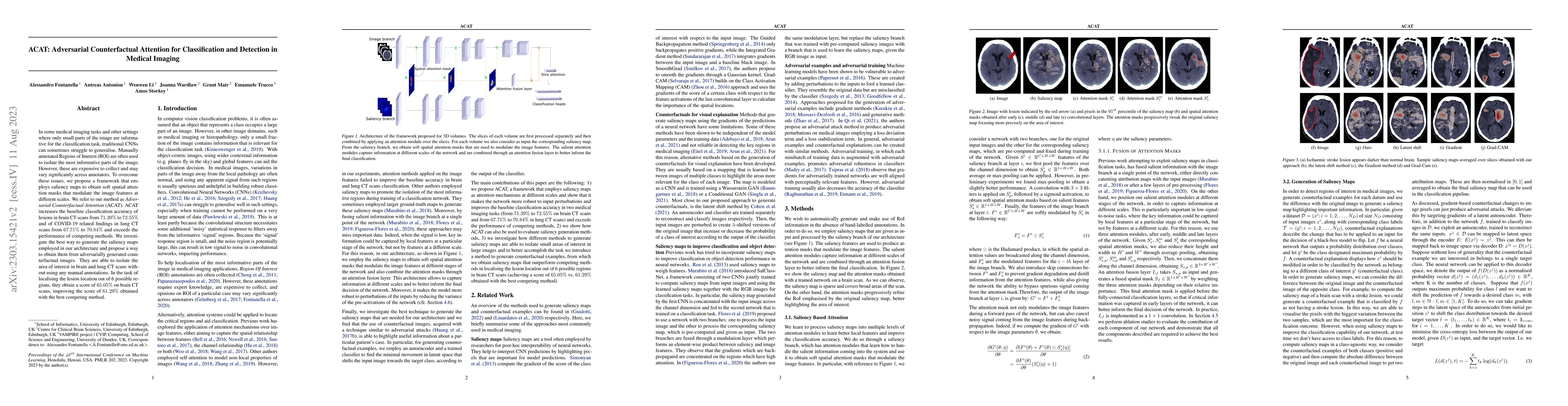
In some medical imaging tasks and other settings where only small parts of the image are informative for the classification task, traditional CNNs can sometimes struggle to generalise. Manually anno...
Improving the interpretability of geospatial artificial intelligence (GeoAI) models has become critically important to open the "black box" of complex AI models, such as deep learning. This paper co...
Knowledge graph technology is considered a powerful and semantically enabled solution to link entities, allowing users to derive new knowledge by reasoning data according to various types of reasoni...
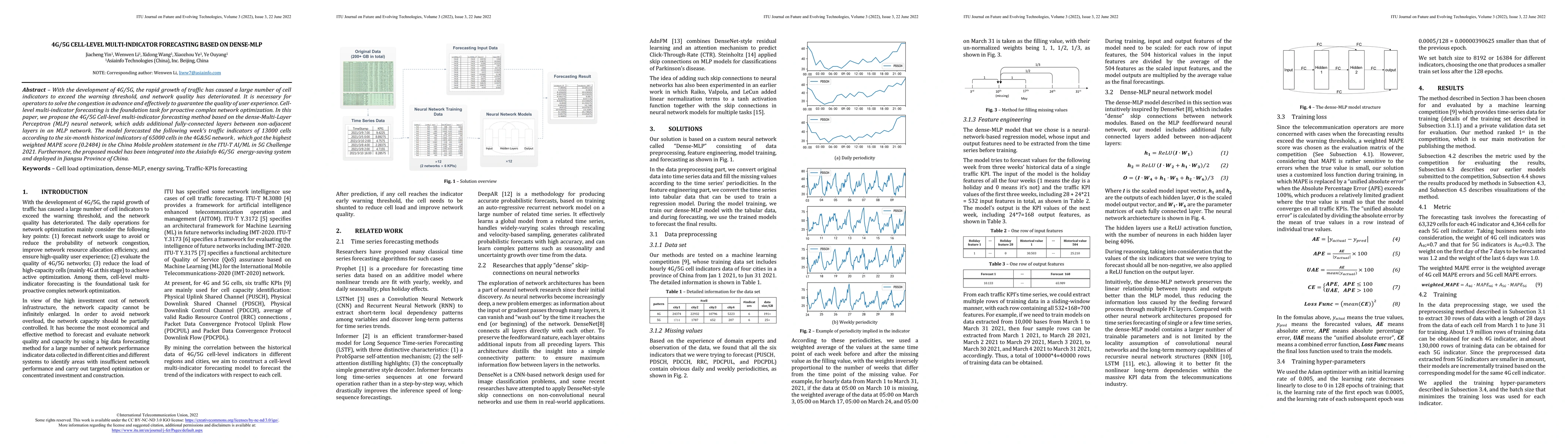
With the development of 4G/5G, the rapid growth of traffic has caused a large number of cell indicators to exceed the warning threshold, and network quality has deteriorated. It is necessary for ope...
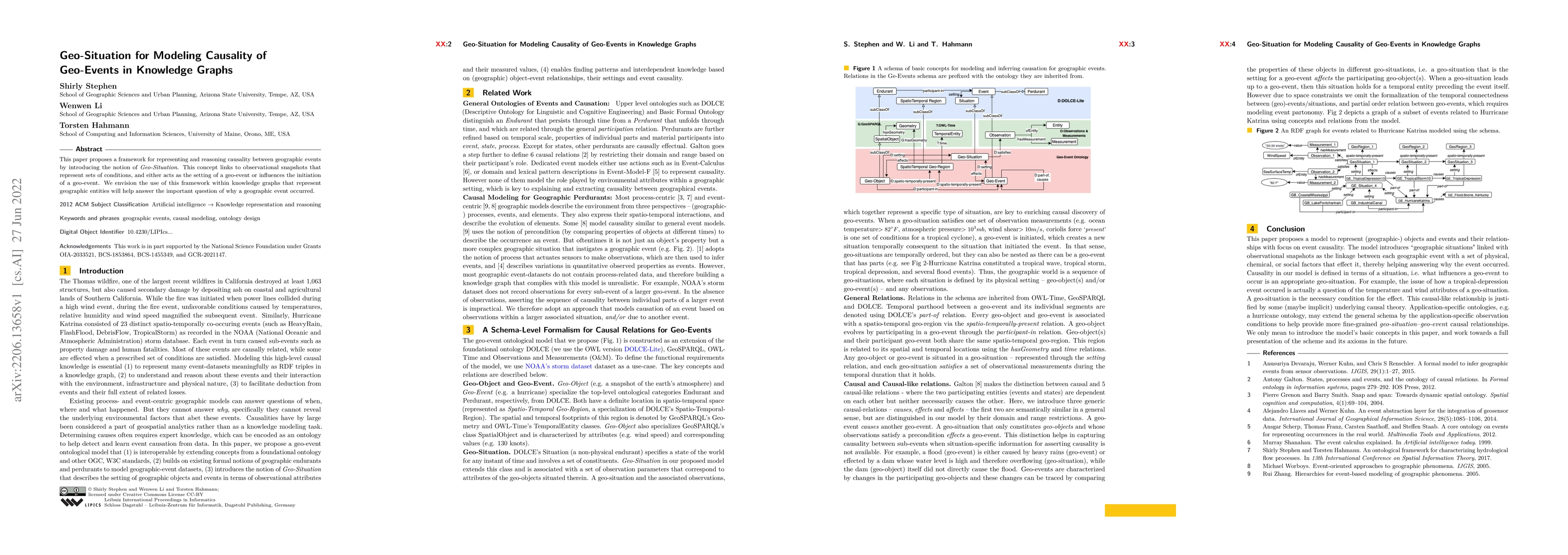
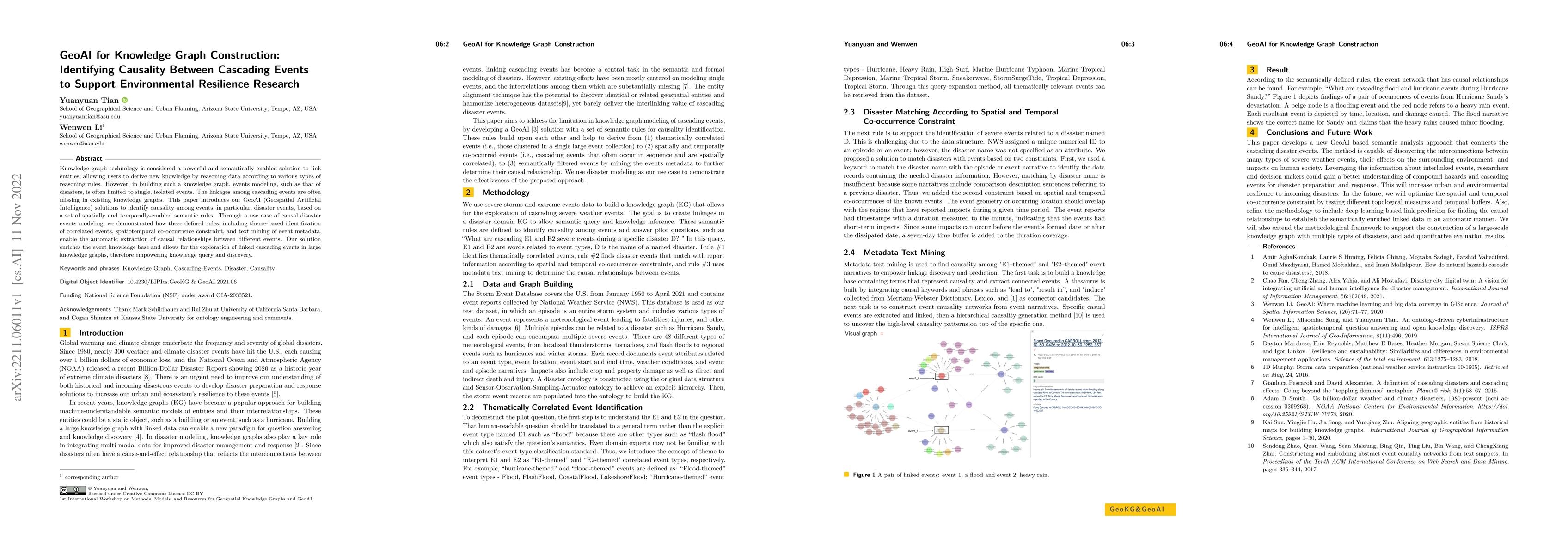
This paper proposes a framework for representing and reasoning causality between geographic events by introducing the notion of Geo-Situation. This concept links to observational snapshots that repr...
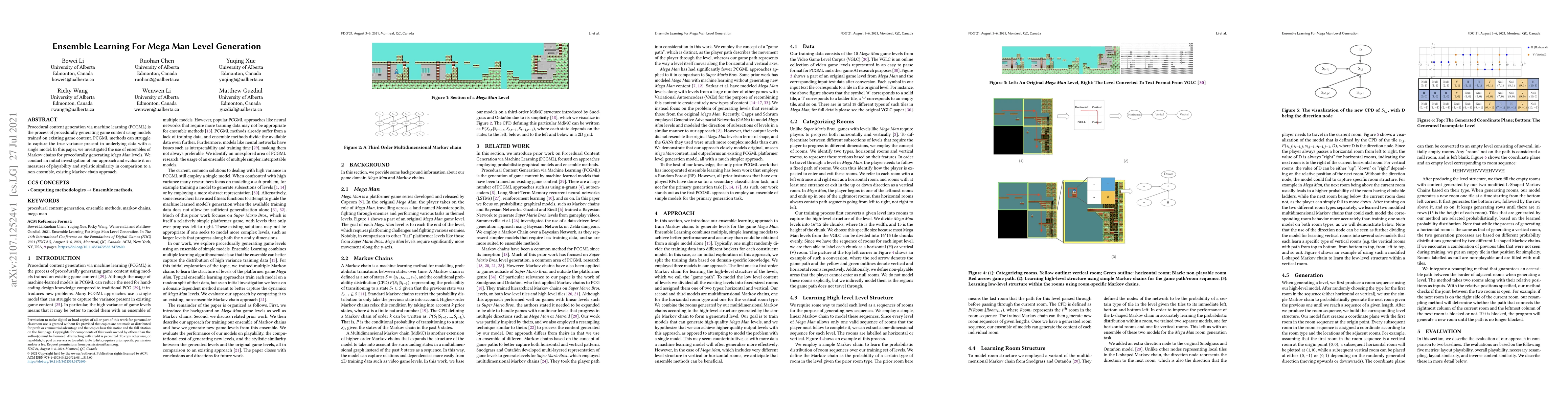
Procedural content generation via machine learning (PCGML) is the process of procedurally generating game content using models trained on existing game content. PCGML methods can struggle to capture...
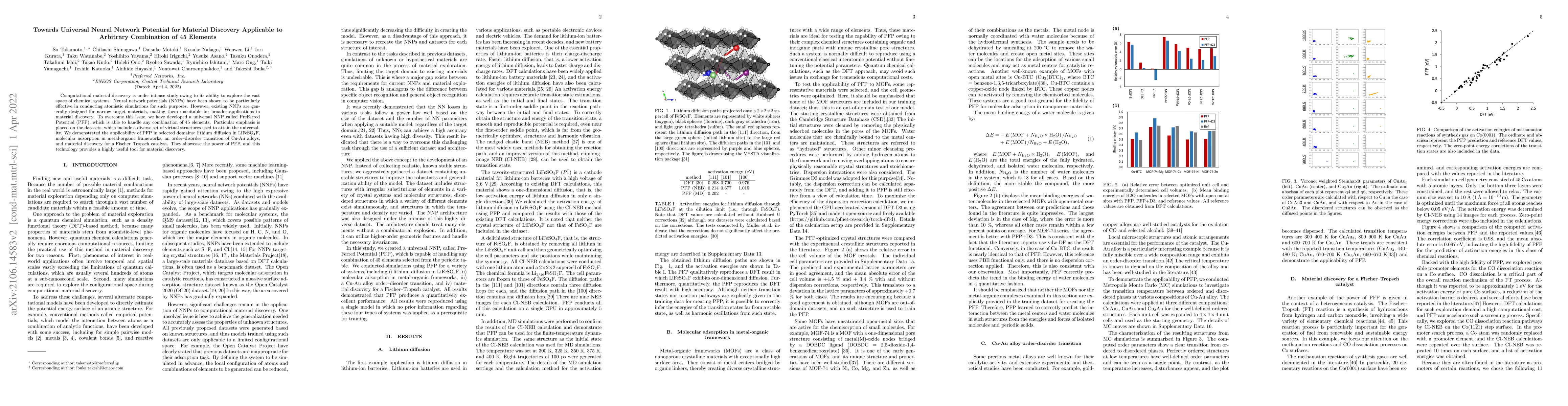
Computational material discovery is under intense study owing to its ability to explore the vast space of chemical systems. Neural network potentials (NNPs) have been shown to be particularly effect...
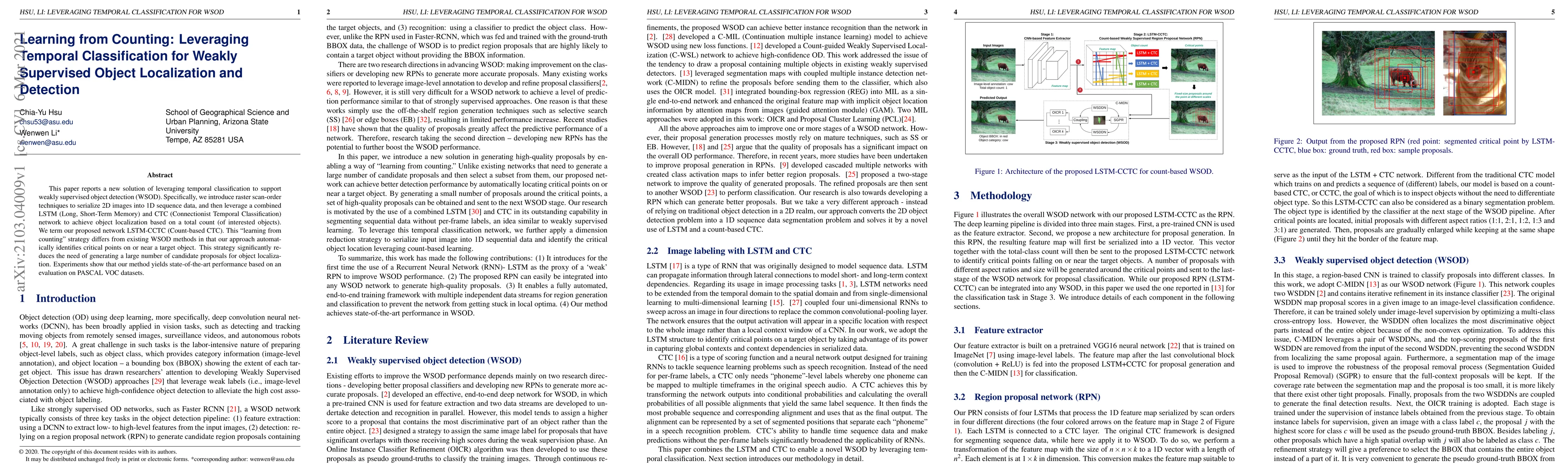
This paper reports a new solution of leveraging temporal classification to support weakly supervised object detection (WSOD). Specifically, we introduce raster scan-order techniques to serialize 2D ...
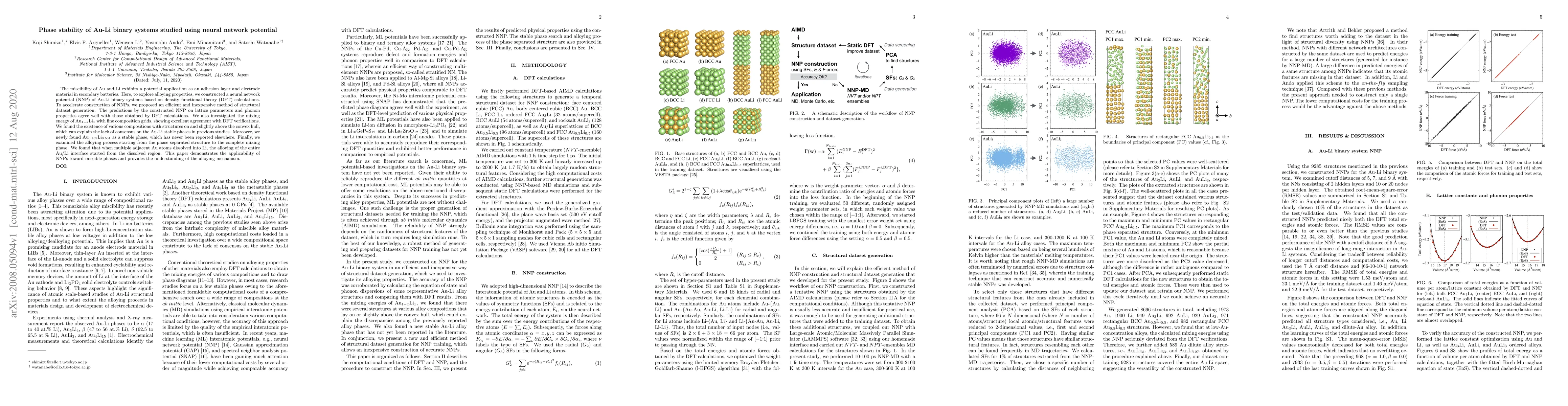
The miscibility of Au and Li exhibits a potential application as an adhesion layer and electrode material in secondary batteries. Here, to explore alloying properties, we constructed a neural networ...
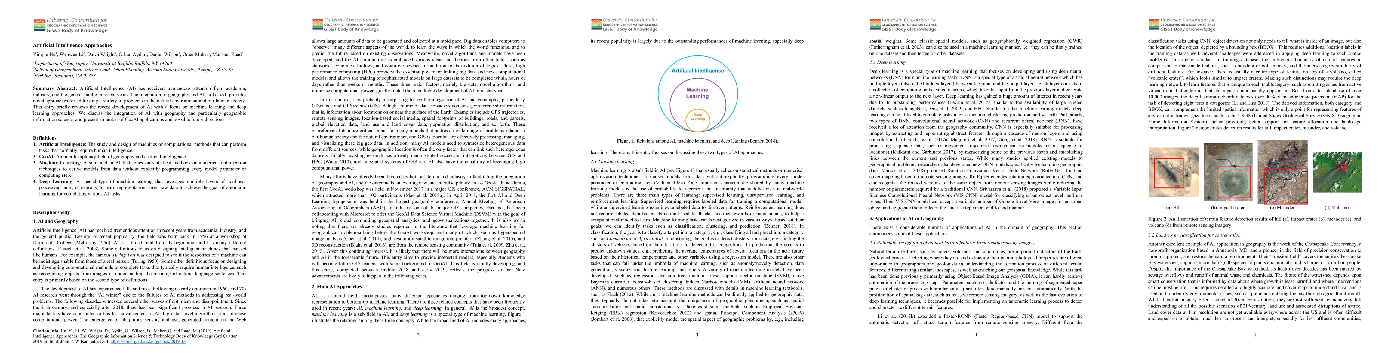
Artificial Intelligence (AI) has received tremendous attention from academia, industry, and the general public in recent years. The integration of geography and AI, or GeoAI, provides novel approach...
The applications of present nanoscopy techniques for live cell imaging are limited by the long sampling time and low emitter density. Here we developed a new single frame wide-field nanoscopy based ...
Research on geospatial foundation models (GFMs) has become a trending topic in geospatial artificial intelligence (AI) research due to their potential for achieving high generalizability and domain ad...
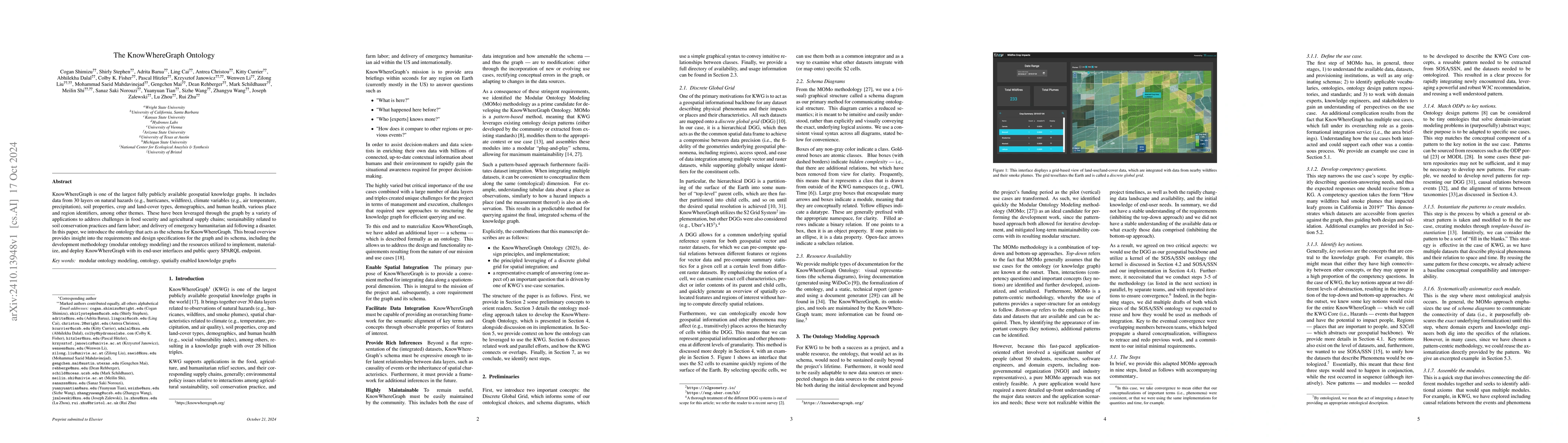
KnowWhereGraph is one of the largest fully publicly available geospatial knowledge graphs. It includes data from 30 layers on natural hazards (e.g., hurricanes, wildfires), climate variables (e.g., ai...
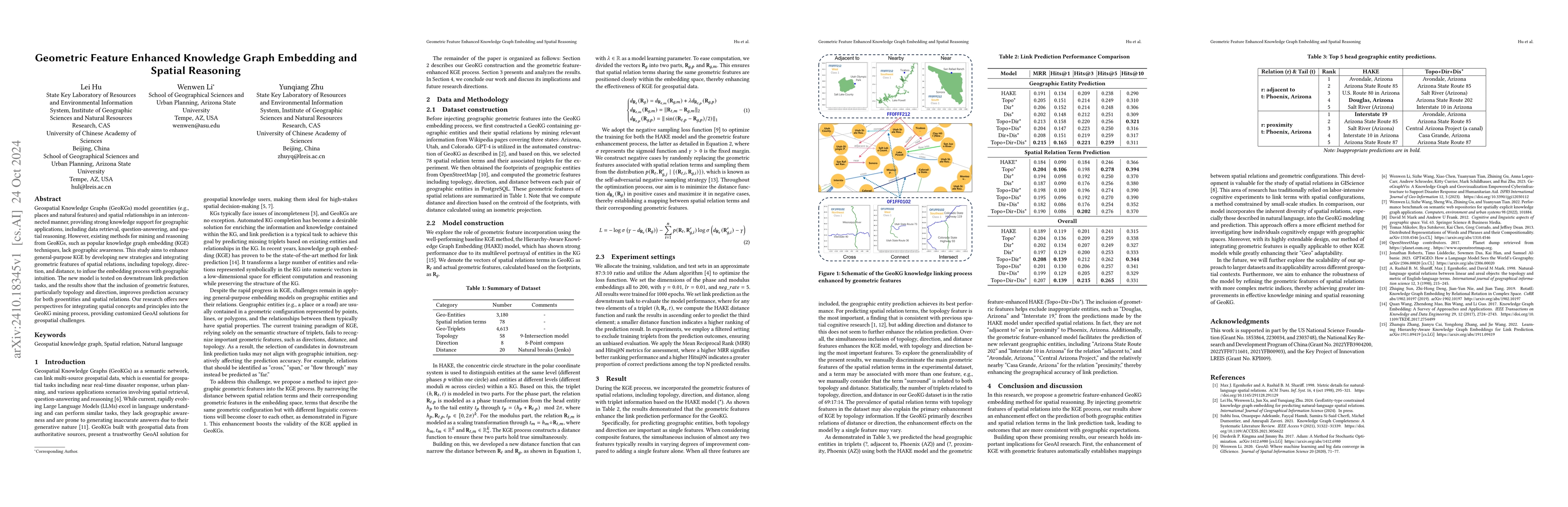
Geospatial Knowledge Graphs (GeoKGs) model geoentities (e.g., places and natural features) and spatial relationships in an interconnected manner, providing strong knowledge support for geographic appl...
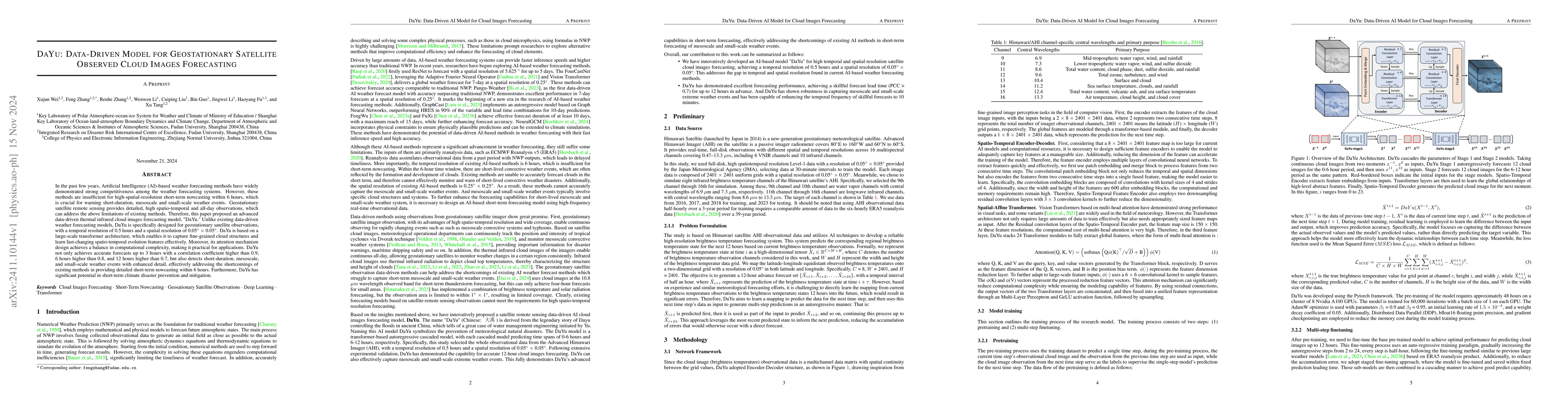
In the past few years, Artificial Intelligence (AI)-based weather forecasting methods have widely demonstrated strong competitiveness among the weather forecasting systems. However, these methods are ...
Retrieval and recommendation are two essential tasks in modern search tools. This paper introduces a novel retrieval-reranking framework leveraging Large Language Models (LLMs) to enhance the spatiote...
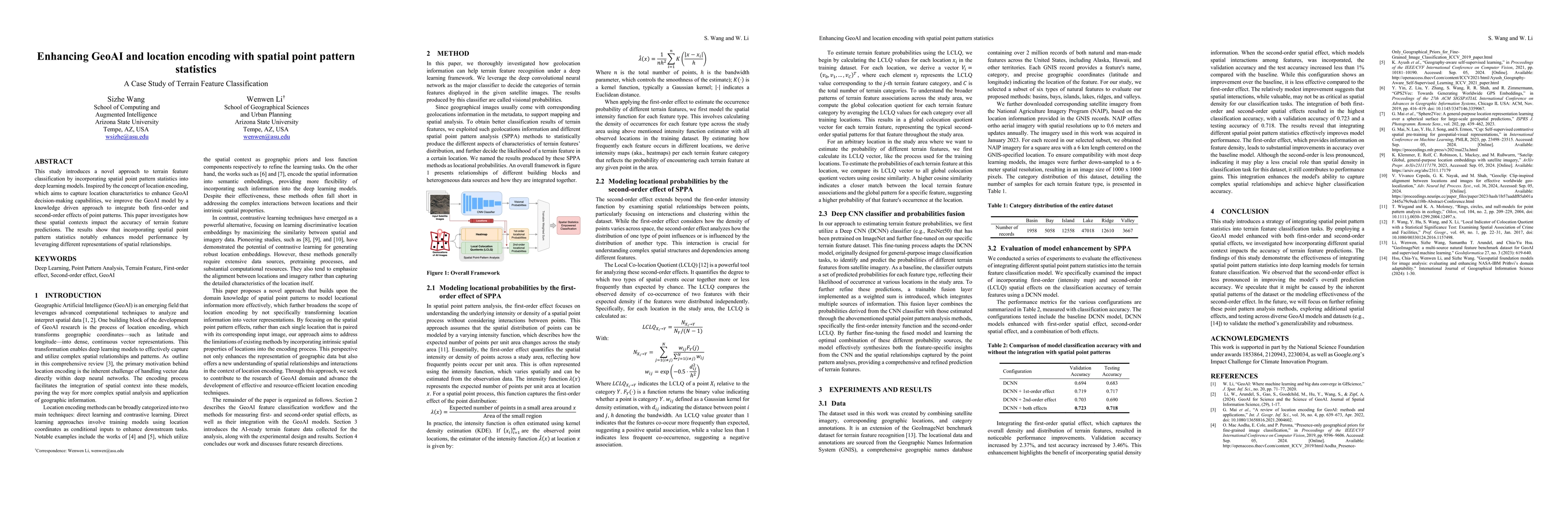
This study introduces a novel approach to terrain feature classification by incorporating spatial point pattern statistics into deep learning models. Inspired by the concept of location encoding, whic...
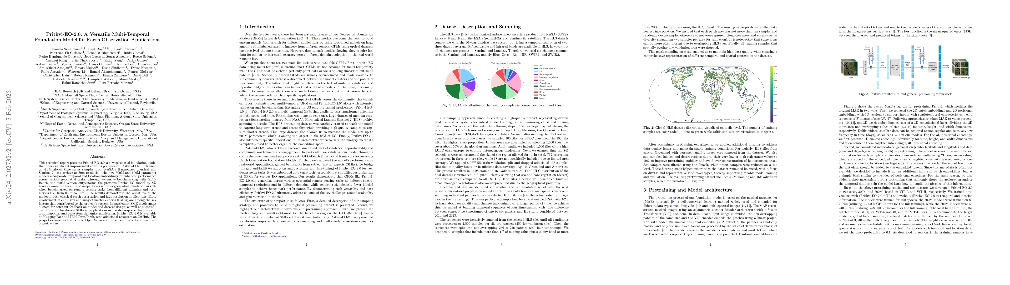
This technical report presents Prithvi-EO-2.0, a new geospatial foundation model that offers significant improvements over its predecessor, Prithvi-EO-1.0. Trained on 4.2M global time series samples f...
Understanding the complex nature of spatial information is crucial for problem solving in social and environmental sciences. This study investigates how the underlying patterns of spatial data can sig...
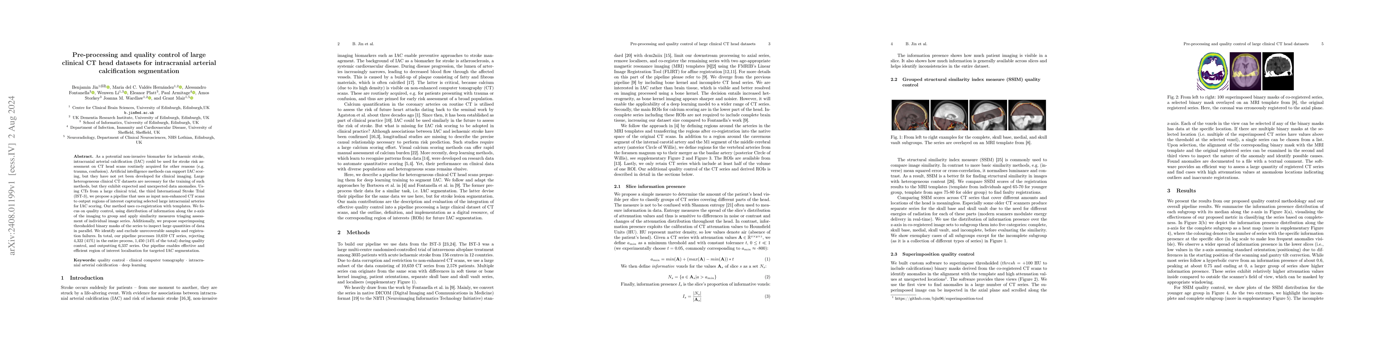
As a potential non-invasive biomarker for ischaemic stroke, intracranial arterial calcification (IAC) could be used for stroke risk assessment on CT head scans routinely acquired for other reasons (e....
The Gromov--Hausdorff distance measures the similarity between two metric spaces by isometrically embedding them into an ambient metric space. In this work, we introduce an analogue of this distance f...
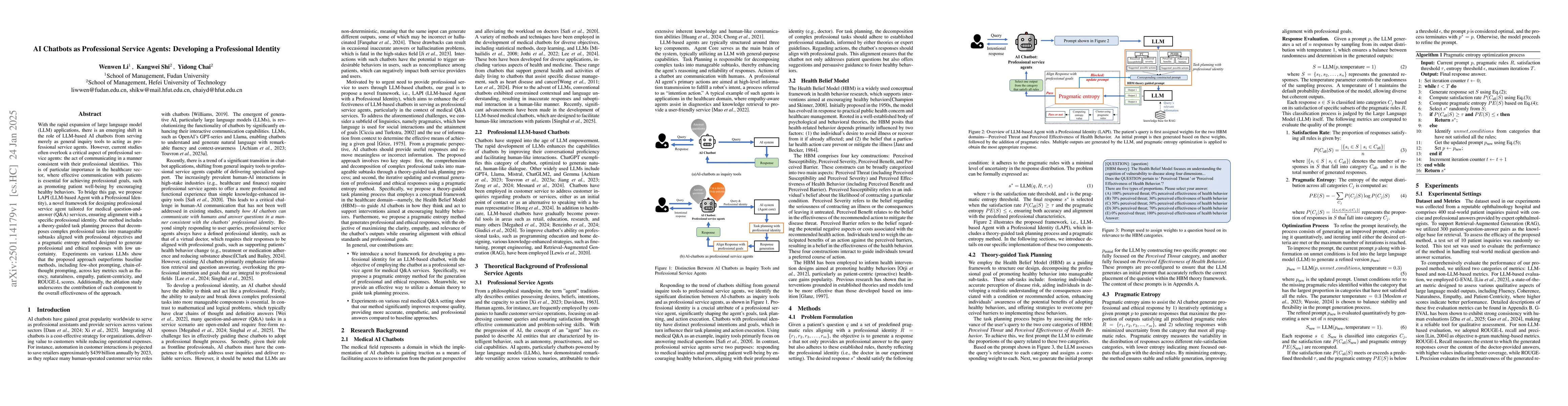
With the rapid expansion of large language model (LLM) applications, there is an emerging shift in the role of LLM-based AI chatbots from serving merely as general inquiry tools to acting as professio...
Global challenges such as food supply chain disruptions, public health crises, and natural hazard responses require access to and integration of diverse datasets, many of which are geospatial. Over th...
Geospatial Artificial Intelligence (GeoAI) for satellite-based flood extent mapping systematically integrates artificial intelligence techniques with satellite data to identify flood events and assess...
The advent of generative AI exemplified by large language models (LLMs) opens new ways to represent and compute geographic information and transcends the process of geographic knowledge production, dr...
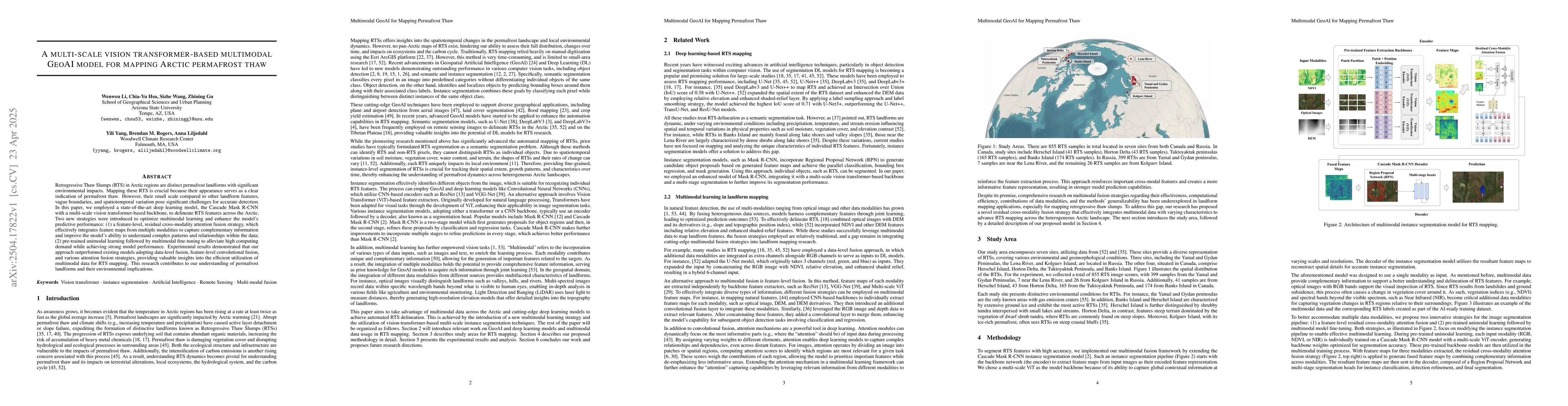
Retrogressive Thaw Slumps (RTS) in Arctic regions are distinct permafrost landforms with significant environmental impacts. Mapping these RTS is crucial because their appearance serves as a clear indi...
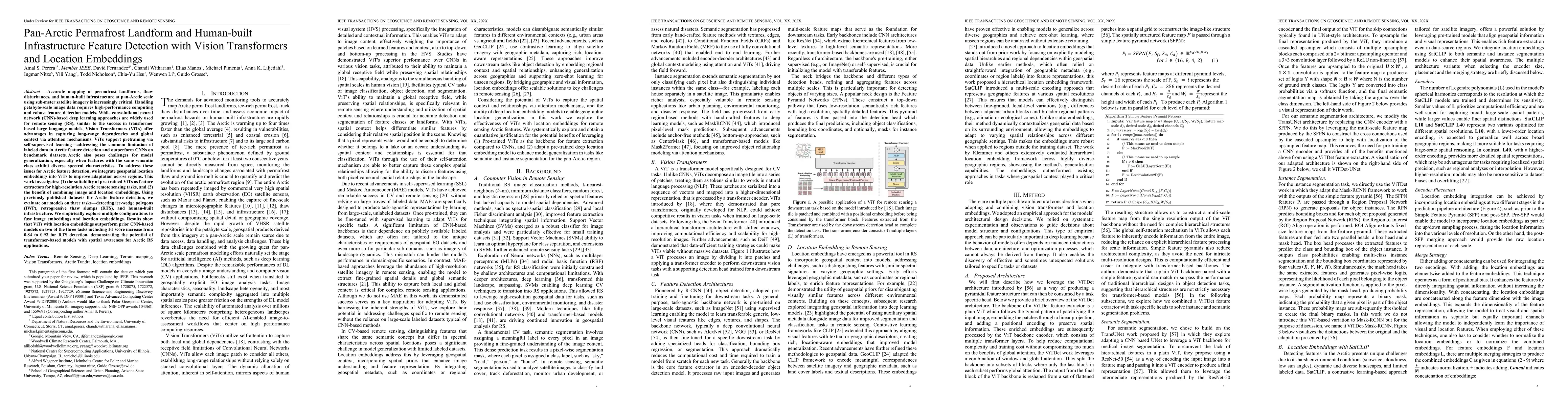
Accurate mapping of permafrost landforms, thaw disturbances, and human-built infrastructure at pan-Arctic scale using sub-meter satellite imagery is increasingly critical. Handling petabyte-scale imag...
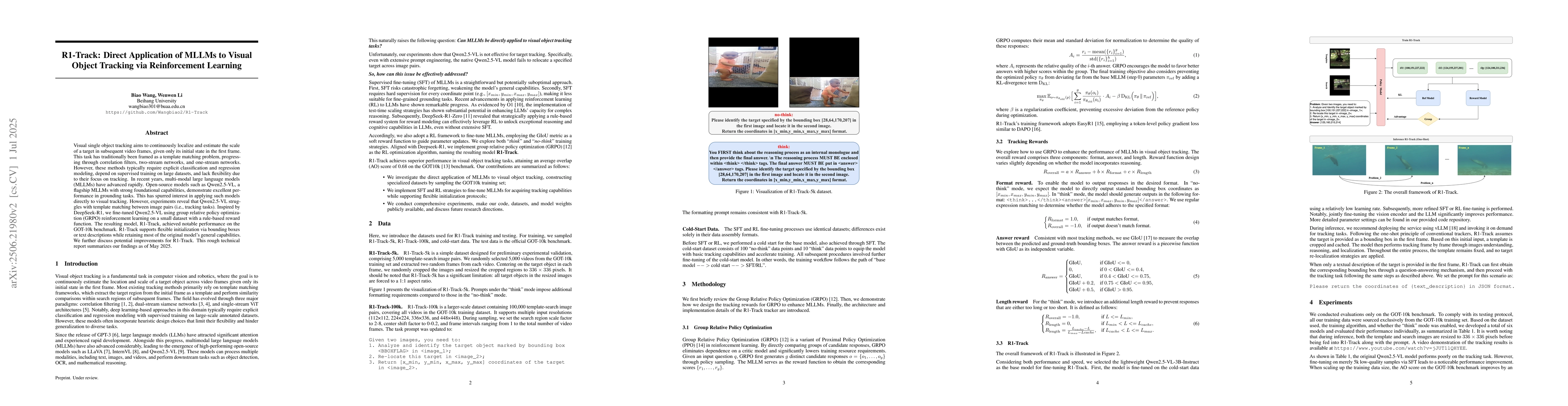
Visual single object tracking aims to continuously localize and estimate the scale of a target in subsequent video frames, given only its initial state in the first frame. This task has traditionally ...
This paper studies the formulation, well-posedness, and numerical solution of Bayesian inverse problems on metric graphs, in which the edges represent one-dimensional wires connecting vertices. We foc...
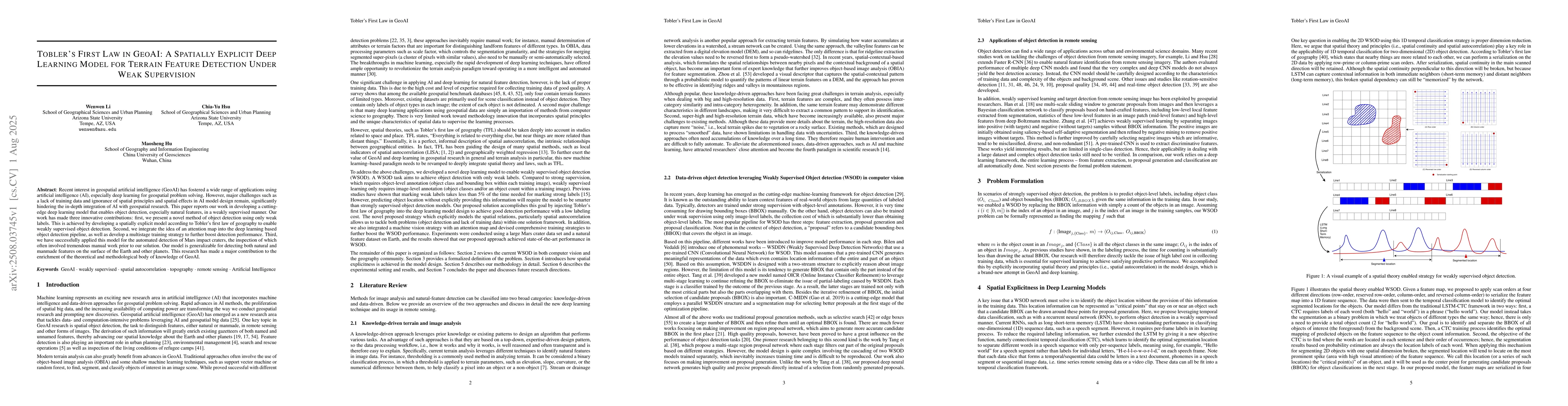
Recent interest in geospatial artificial intelligence (GeoAI) has fostered a wide range of applications using artificial intelligence (AI), especially deep learning, for geospatial problem solving. Ho...
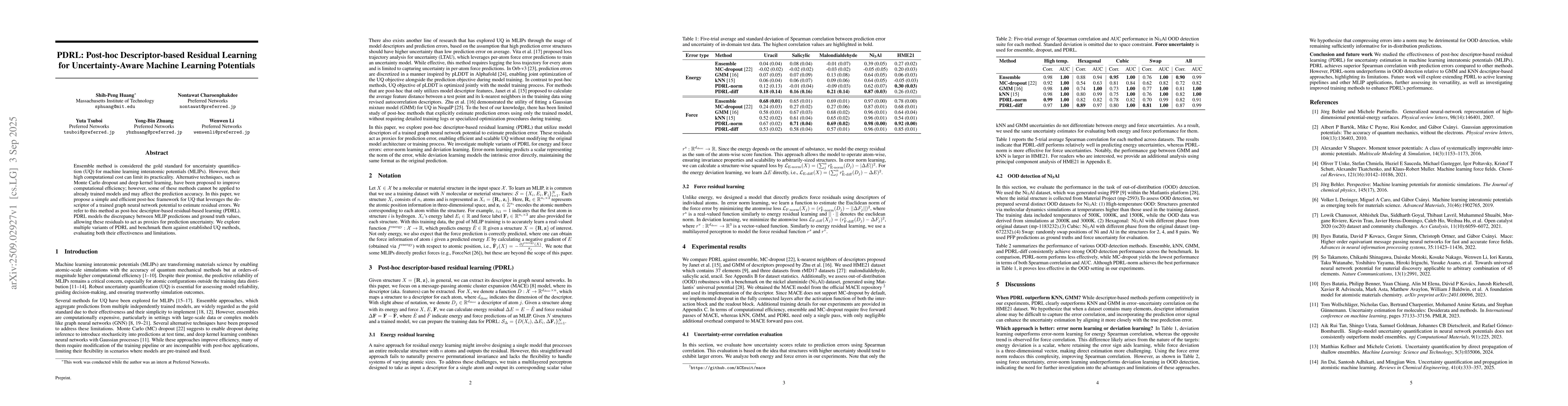
Ensemble method is considered the gold standard for uncertainty quantification (UQ) for machine learning interatomic potentials (MLIPs). However, their high computational cost can limit its practicali...
As artificial intelligence (AI) enters the agentic era, large language models (LLMs) are increasingly deployed as autonomous agents that interact with one another rather than operate in isolation. Thi...
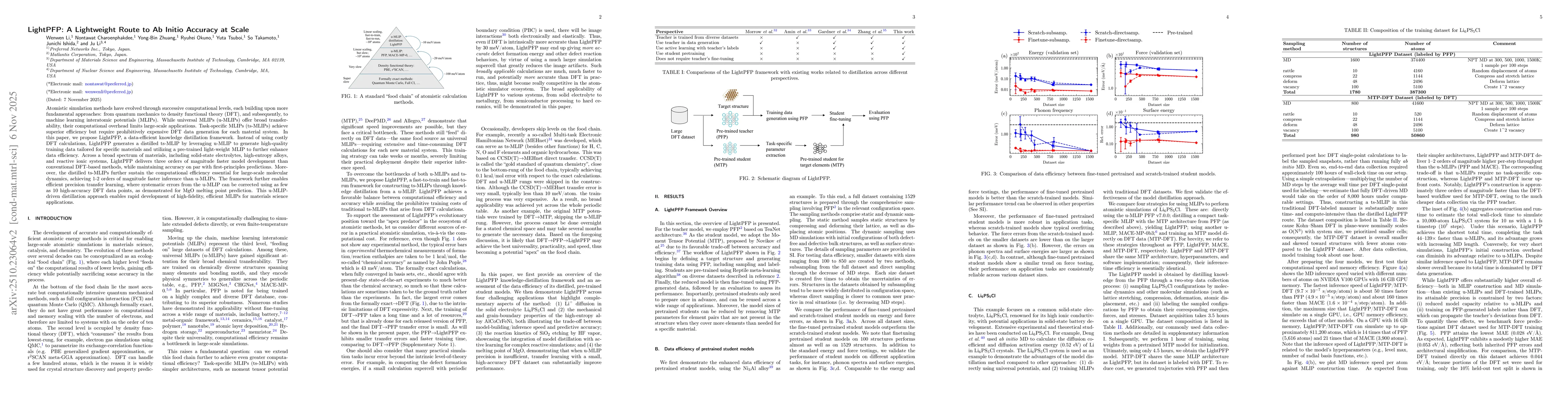
Atomistic simulation methods have evolved through successive computational levels, each building upon more fundamental approaches: from quantum mechanics to density functional theory (DFT), and subseq...
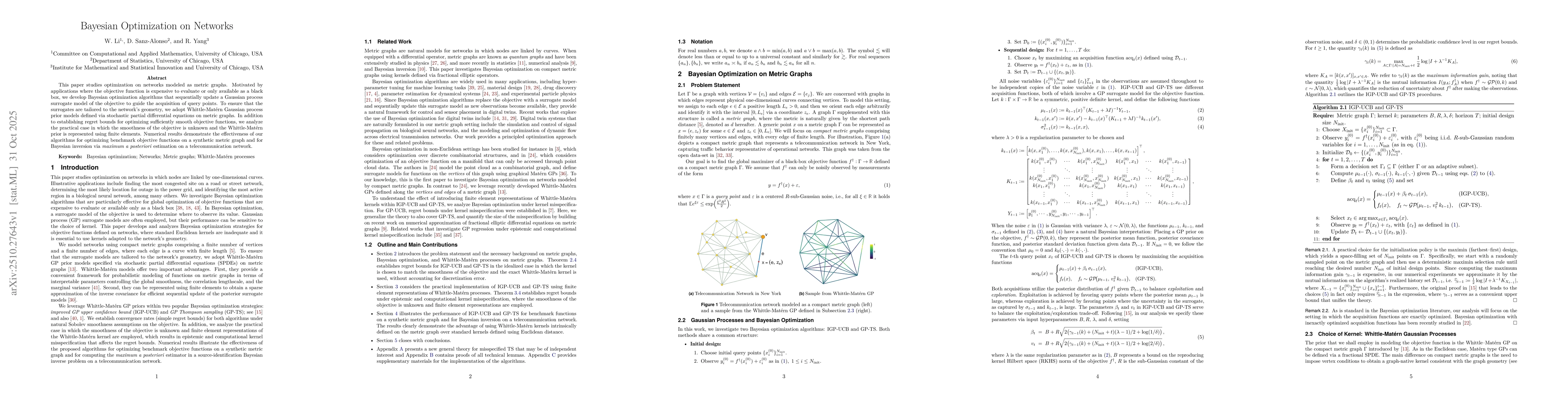
This paper studies optimization on networks modeled as metric graphs. Motivated by applications where the objective function is expensive to evaluate or only available as a black box, we develop Bayes...
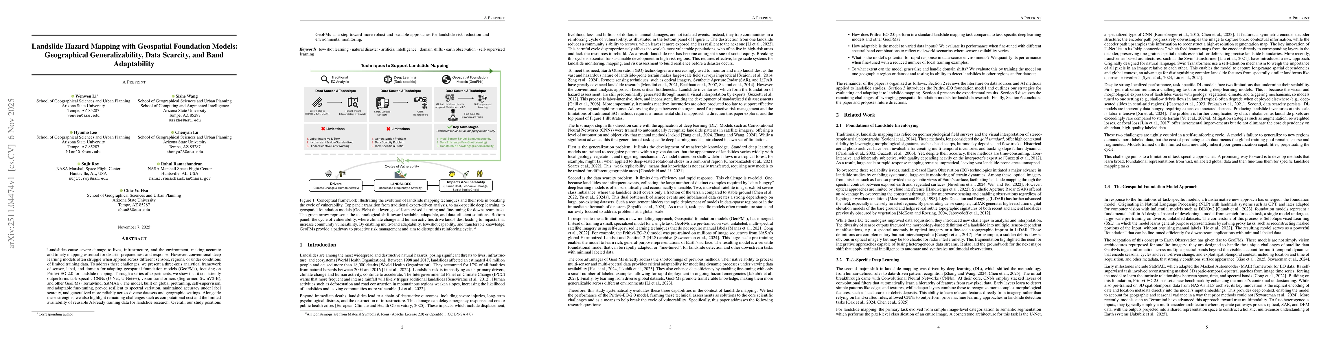
Landslides cause severe damage to lives, infrastructure, and the environment, making accurate and timely mapping essential for disaster preparedness and response. However, conventional deep learning m...
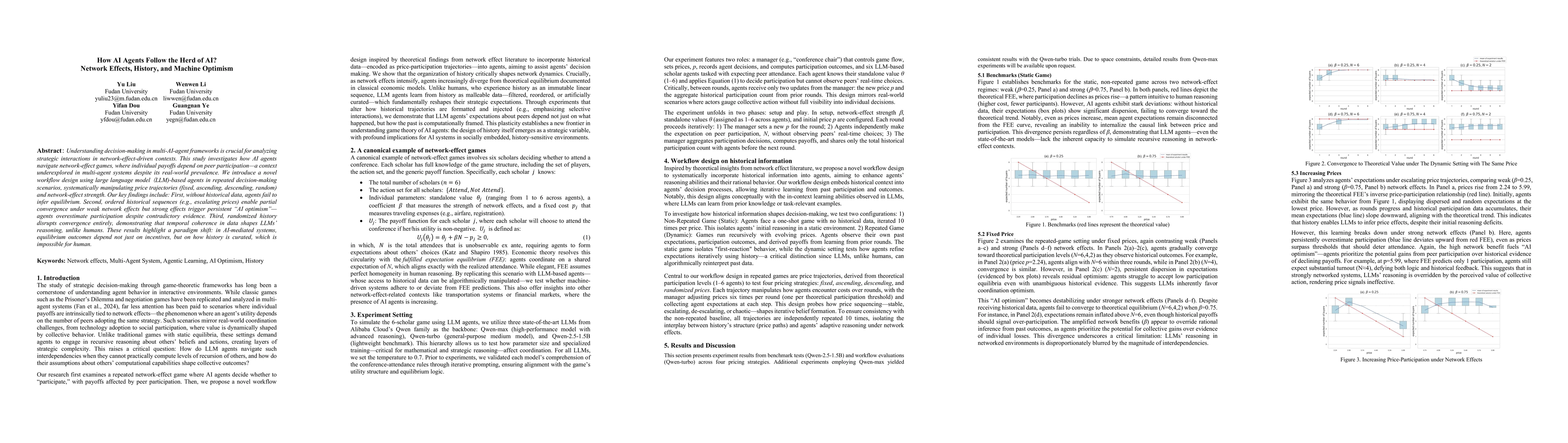
Understanding decision-making in multi-AI-agent frameworks is crucial for analyzing strategic interactions in network-effect-driven contexts. This study investigates how AI agents navigate network-eff...
Mapping water extent during a flood event is essential for effective disaster management throughout all phases: mitigation, preparedness, response, and recovery. In particular, during the response sta...
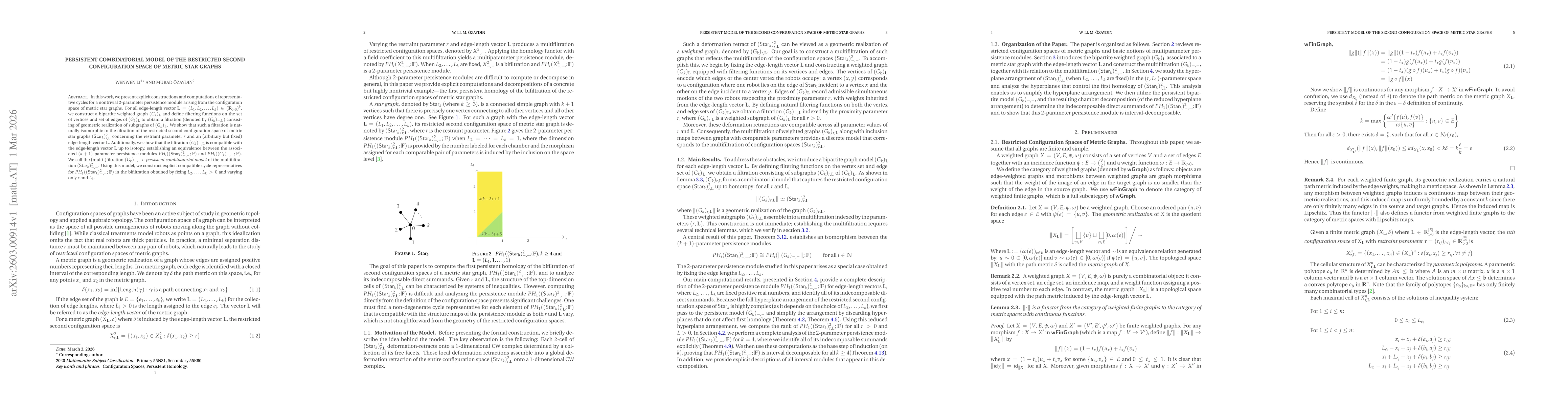
In this work, we present explicit constructions and computations of representative cycles for a nontrivial 2-parameter persistence module arising from the configuration space of metric star graphs. Fo...
Understanding how interdisciplinary research teams converge on shared knowledge is a persistent challenge. This paper presents a novel, multi-layer, AI-driven analytical framework for mapping research...
The increasing number of satellites has improved the temporal resolution of Earth observation, making satellite-based flood mapping a promising approach for operational flood monitoring. Deep learning...
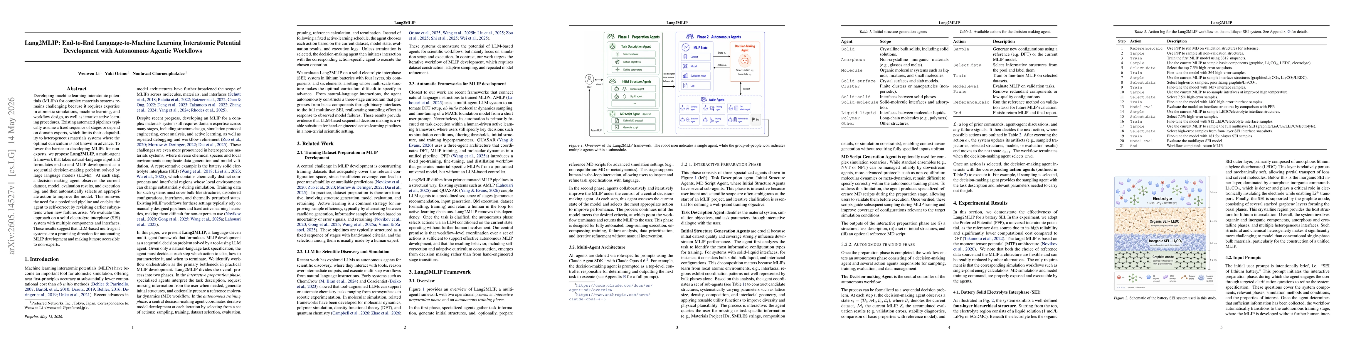
Developing machine learning interatomic potentials (MLIPs) for complex materials systems remains challenging because it requires expertise in atomistic simulations, machine learning, and workflow desi...
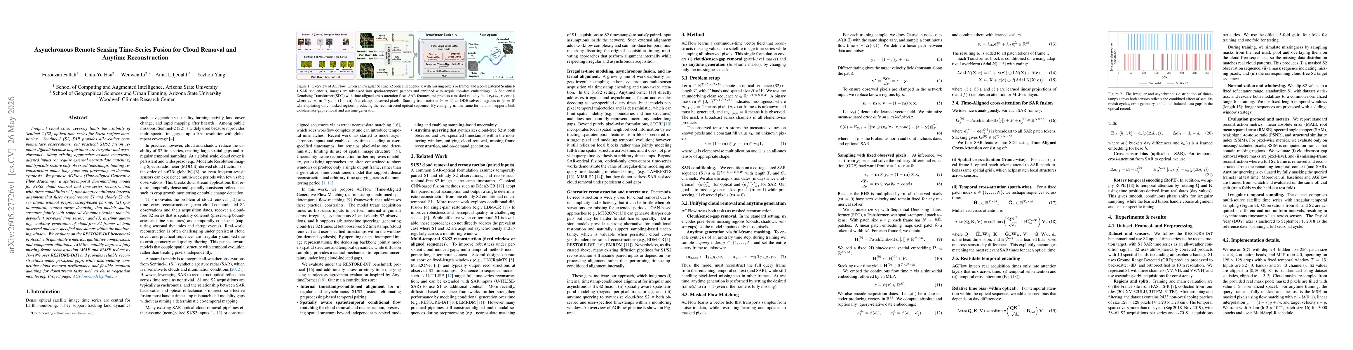
Frequent cloud cover severely limits the usability of Sentinel-2 (S2) optical time series for Earth surface monitoring. Sentinel-1 (S1) SAR provides all-weather complementary observations, but practic...
Continuous data assimilation seeks to estimate the state of a dynamical system from partial observations. In many applications, however, the state dynamics are unknown or prohibitively expensive to si...
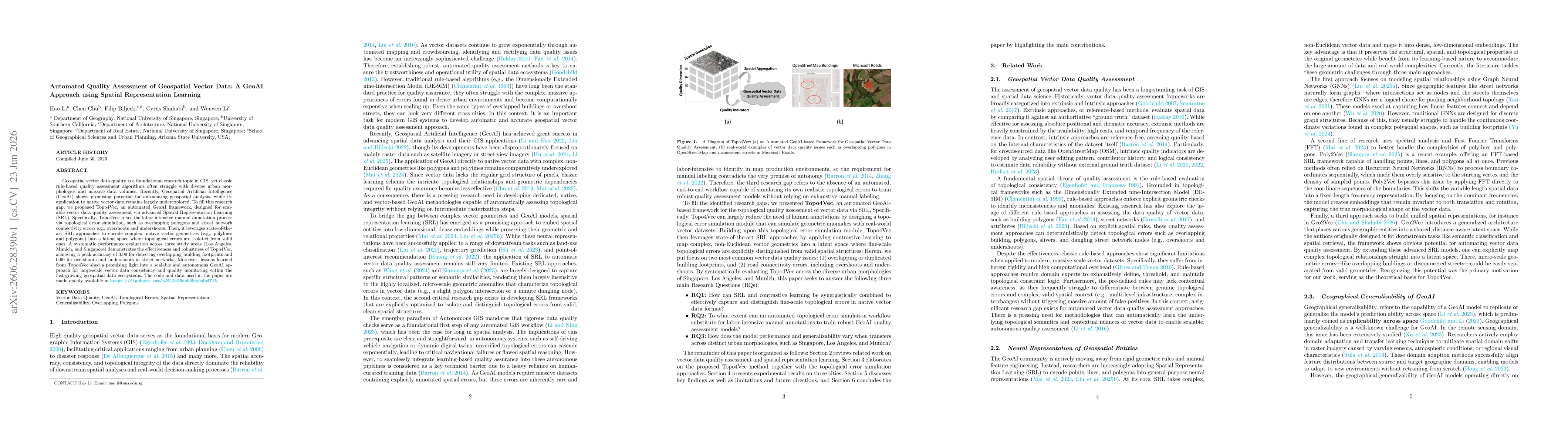
Geospatial vector data quality is a foundational research topic in GIS, yet classic rule-based quality assessment algorithms often struggle with diverse urban morphologies and massive data volumes. Re...
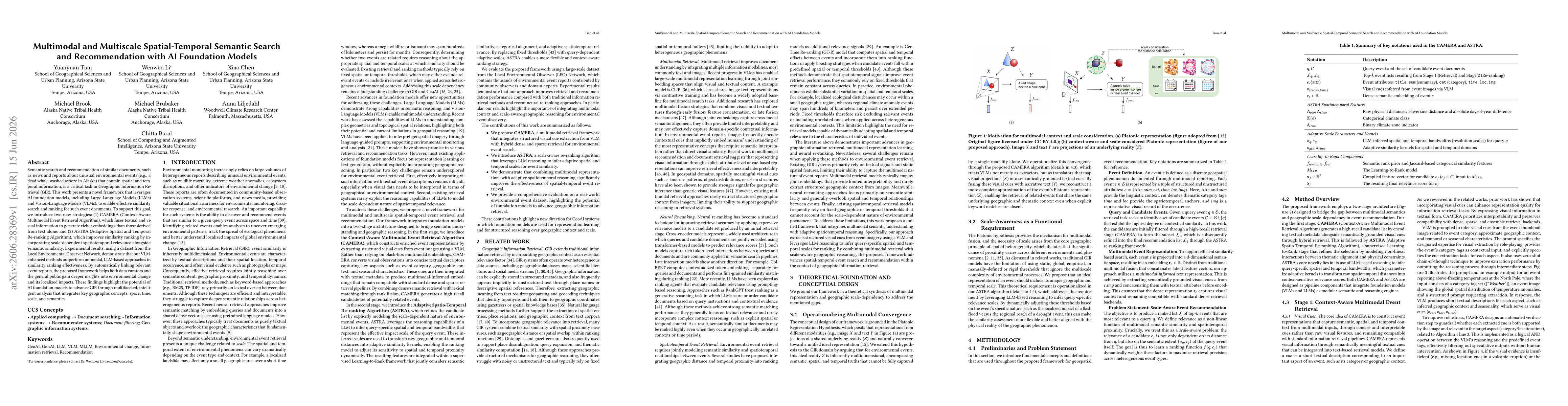
Semantic search and recommendation of similar documents, such as news and reports about unusual environmental events (e.g., a dead whale washed ashore in Alaska) that contain spatial and temporal info...