AI Quick Summary
A new deep learning model using a vision transformer-based backbone outperforms existing models in detecting Retrogressive Thaw Slumps in Arctic permafrost regions with improved multimodal learning strategies.
Quick Answers
What is "A multi-scale vision transformer-based multimodal GeoAI model for mapping Arctic permafrost thaw" about?
A new deep learning model using a vision transformer-based backbone outperforms existing models in detecting Retrogressive Thaw Slumps in Arctic permafrost regions with improved multimodal learning strategies.
What methodology did the authors use?
The research employs a multi-scale vision transformer-based multimodal GeoAI model using Cascade Mask R-CNN with a novel residual cross-modality attention fusion strategy for mapping Arctic permafrost thaw, specifically Retrogressive Thaw Slumps (RTS). More in Methodology →
What are the key results?
The proposed method outperforms existing models adopting data-level fusion, feature-level convolutional fusion, and various attention fusion strategies. — Pre-trained unimodal learning followed by multimodal fine-tuning significantly reduces computing demand while achieving strong model performance. More in Key Results →
Why is this work significant?
This research contributes to understanding permafrost landforms and their environmental implications, providing a robust method for mapping RTS, which are clear indicators of permafrost thaw in Arctic regions. More in Significance →
What are the main limitations?
The study is limited to the specific context of Arctic permafrost thaw mapping using RTS as the primary landform of interest. — Generalizability to other permafrost thaw indicators or non-Arctic regions remains to be explored. More in Limitations →
Abstract
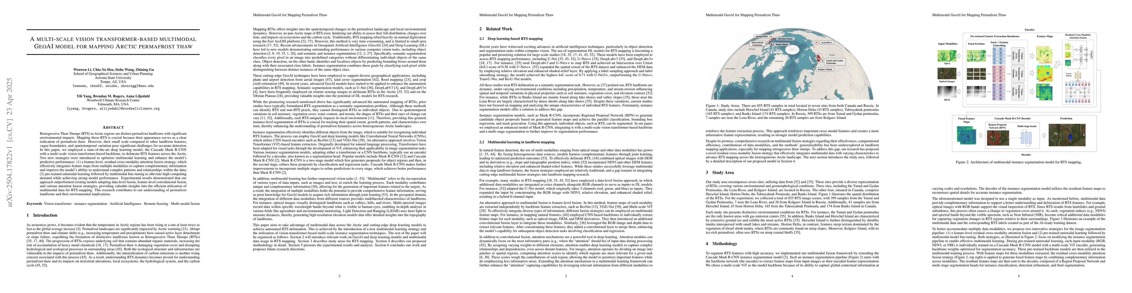
Retrogressive Thaw Slumps (RTS) in Arctic regions are distinct permafrost landforms with significant environmental impacts. Mapping these RTS is crucial because their appearance serves as a clear indication of permafrost thaw. However, their small scale compared to other landform features, vague boundaries, and spatiotemporal variation pose significant challenges for accurate detection. In this paper, we employed a state-of-the-art deep learning model, the Cascade Mask R-CNN with a multi-scale vision transformer-based backbone, to delineate RTS features across the Arctic. Two new strategies were introduced to optimize multimodal learning and enhance the model's predictive performance: (1) a feature-level, residual cross-modality attention fusion strategy, which effectively integrates feature maps from multiple modalities to capture complementary information and improve the model's ability to understand complex patterns and relationships within the data; (2) pre-trained unimodal learning followed by multimodal fine-tuning to alleviate high computing demand while achieving strong model performance. Experimental results demonstrated that our approach outperformed existing models adopting data-level fusion, feature-level convolutional fusion, and various attention fusion strategies, providing valuable insights into the efficient utilization of multimodal data for RTS mapping. This research contributes to our understanding of permafrost landforms and their environmental implications.
AI Key Findings
Generated Jun 09, 2025
Methodology — What approach did the authors take?
The research employs a multi-scale vision transformer-based multimodal GeoAI model using Cascade Mask R-CNN with a novel residual cross-modality attention fusion strategy for mapping Arctic permafrost thaw, specifically Retrogressive Thaw Slumps (RTS).
Key Results — What are the main findings?
- The proposed method outperforms existing models adopting data-level fusion, feature-level convolutional fusion, and various attention fusion strategies.
- Pre-trained unimodal learning followed by multimodal fine-tuning significantly reduces computing demand while achieving strong model performance.
- The residual cross-modality attention fusion strategy enhances the model's ability to understand complex patterns and relationships within the data.
- Experimental results demonstrate the efficiency of multimodal data utilization for RTS mapping.
Significance — Why does this research matter?
This research contributes to understanding permafrost landforms and their environmental implications, providing a robust method for mapping RTS, which are clear indicators of permafrost thaw in Arctic regions.
Technical Contribution — What is the technical contribution?
The paper introduces a novel residual cross-modality attention fusion strategy for multimodal learning, combined with a pre-trained unimodal learning and multimodal fine-tuning approach, to optimize the detection of small-scale, complex landforms like RTS in Arctic regions.
Novelty — What is new about this work?
The research presents a unique multimodal GeoAI model that effectively addresses the challenges of mapping small-scale permafrost thaw landforms by integrating a residual cross-modality attention fusion strategy, pre-trained unimodal learning, and multimodal fine-tuning, outperforming existing methods in RTS detection.
Limitations — What are the limitations of this study?
- The study is limited to the specific context of Arctic permafrost thaw mapping using RTS as the primary landform of interest.
- Generalizability to other permafrost thaw indicators or non-Arctic regions remains to be explored.
Future Work — What did the authors propose for future work?
- Investigate the applicability of the proposed method to other permafrost thaw indicators and diverse geographical contexts.
- Explore the integration of additional data modalities to further enhance the model's performance and robustness.
How to Cite This Paper
@article{liljedahl2025a,
title = {A multi-scale vision transformer-based multimodal GeoAI model for
mapping Arctic permafrost thaw},
author = {Liljedahl, Anna and Rogers, Brendan M. and Hsu, Chia-Yu and others},
year = {2025},
eprint = {2504.17822},
archivePrefix = {arXiv},
primaryClass = {cs.CV},
}
Liljedahl, A., Rogers, B., Hsu, C., Wang, S., Li, W., Yang, Y., & Gu, Z. (2025). A multi-scale vision transformer-based multimodal GeoAI model for
mapping Arctic permafrost thaw. arXiv. https://arxiv.org/abs/2504.17822
Liljedahl, Anna, et al. "A multi-scale vision transformer-based multimodal GeoAI model for
mapping Arctic permafrost thaw." arXiv, 2025, arxiv.org/abs/2504.17822.
PDF Preview
Citation Network
Current paper (gray), citations (green), references (blue)
Display is limited for performance on very large graphs.
Similar Papers
Found 4 papersReal-time GeoAI for High-resolution Mapping and Segmentation of Arctic Permafrost Features
Wenwen Li, Chia-Yu Hsu, Chandi Witharana et al.
Preserving Vertical Structure in 3D-to-2D Projection for Permafrost Thaw Mapping
Justin McMillen, Robert Van Alphen, Taha Sadeghi Chorsi et al.
Pan-Arctic Permafrost Landform and Human-built Infrastructure Feature Detection with Vision Transformers and Location Embeddings
Amal S. Perera, David Fernandez, Chandi Witharana et al.
No citations found for this paper.
Comments (0)