ArxivLens
X
Researcher

Xiaoji Niu

23 papers on arXiv

23 arXiv Papers
20 Total Publications
Profile

Academic Profile

Name Xiaojia Niu
Total Papers 20
Scholar Profile View on Semantic Scholar
Metrics

Statistics

23 arXiv Papers
20 Total Publications
Publications

Papers on arXiv

Thumbnail for BA-LINS: A Frame-to-Frame Bundle Adjustment for LiDAR-Inertial
  Navigation
arXiv
BA-LINS: A Frame-to-Frame Bundle Adjustment for LiDAR-Inertial Navigation

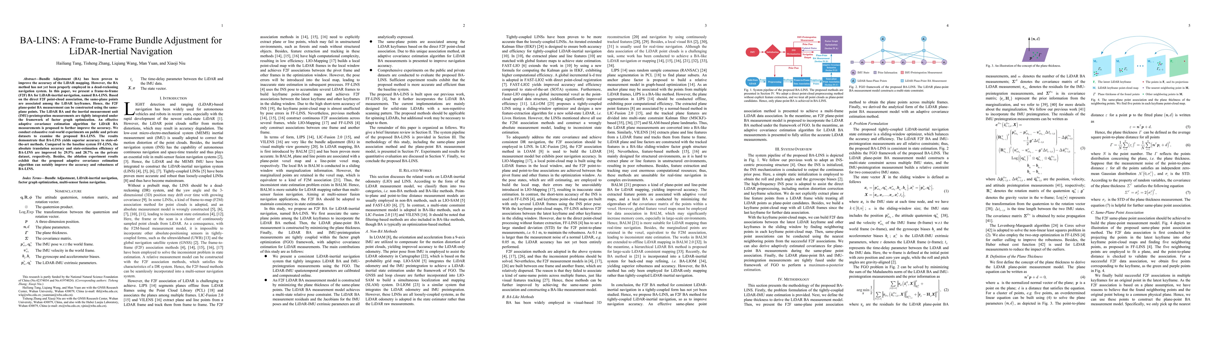
Bundle Adjustment (BA) has been proven to improve the accuracy of the LiDAR mapping. However, the BA method has not yet been properly employed in a dead-reckoning navigation system. In this paper, w...

Thumbnail for SE-LIO: Semantics-enhanced Solid-State-LiDAR-Inertial Odometry for
  Tree-rich Environments
arXiv
SE-LIO: Semantics-enhanced Solid-State-LiDAR-Inertial Odometry for Tree-rich Environments

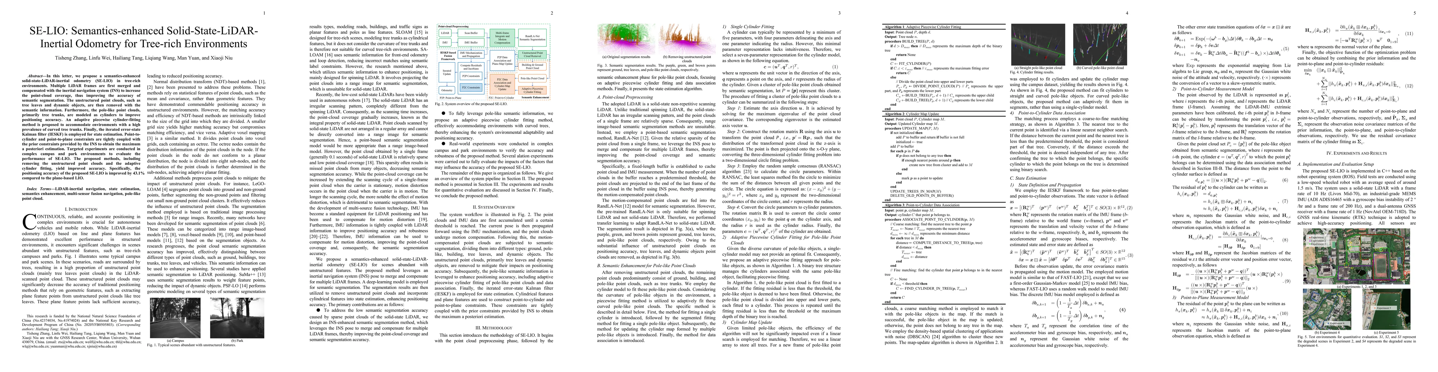
In this letter, we propose a semantics-enhanced solid-state-LiDAR-inertial odometry (SE-LIO) in tree-rich environments. Multiple LiDAR frames are first merged and compensated with the inertial navig...

Thumbnail for FF-LINS: A Consistent Frame-to-Frame Solid-State-LiDAR-Inertial State
  Estimator
arXiv
FF-LINS: A Consistent Frame-to-Frame Solid-State-LiDAR-Inertial State Estimator

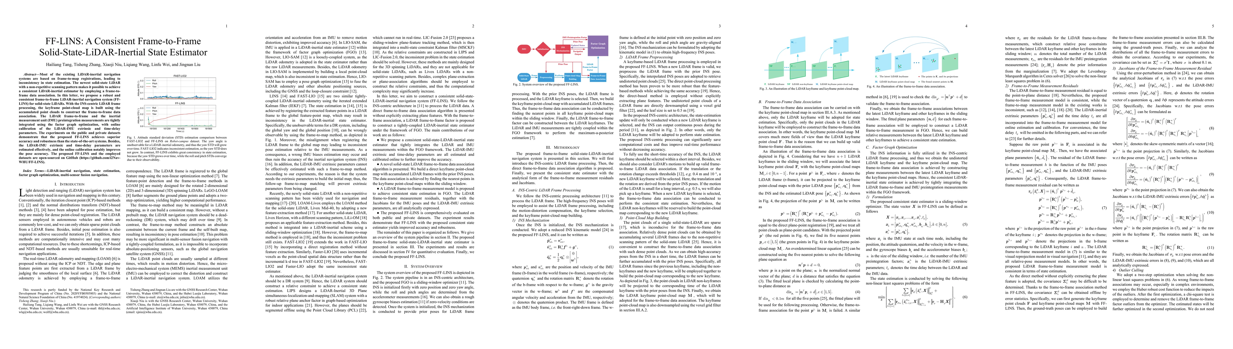
Most of the existing LiDAR-inertial navigation systems are based on frame-to-map registrations, leading to inconsistency in state estimation. The newest solid-state LiDAR with a non-repetitive scann...

Thumbnail for DynaVIG: Monocular Vision/INS/GNSS Integrated Navigation and Object
  Tracking for AGV in Dynamic Scenes
arXiv
DynaVIG: Monocular Vision/INS/GNSS Integrated Navigation and Object Tracking for AGV in Dynamic Scenes

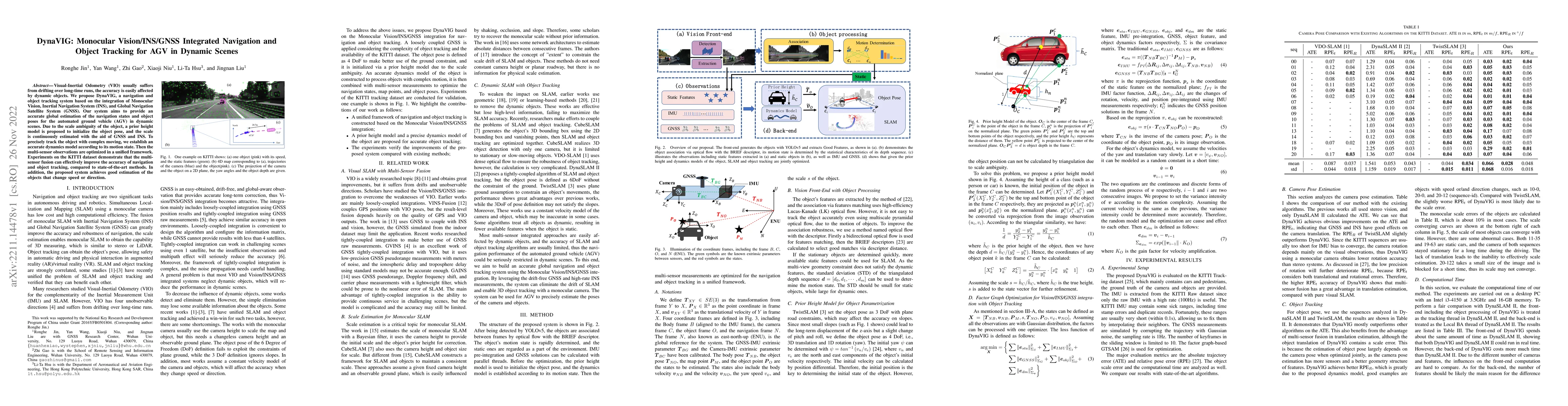
Visual-Inertial Odometry (VIO) usually suffers from drifting over long-time runs, the accuracy is easily affected by dynamic objects. We propose DynaVIG, a navigation and object tracking system base...

Thumbnail for Wheel-SLAM: Simultaneous Localization and Terrain Mapping Using One
  Wheel-mounted IMU
arXiv
Wheel-SLAM: Simultaneous Localization and Terrain Mapping Using One Wheel-mounted IMU

A reliable pose estimator robust to environmental disturbances is desirable for mobile robots. To this end, inertial measurement units (IMUs) play an important role because they can perceive the ful...

Thumbnail for IC-GVINS: A Robust, Real-time, INS-Centric GNSS-Visual-Inertial
  Navigation System for Wheeled Robot
arXiv
IC-GVINS: A Robust, Real-time, INS-Centric GNSS-Visual-Inertial Navigation System for Wheeled Robot

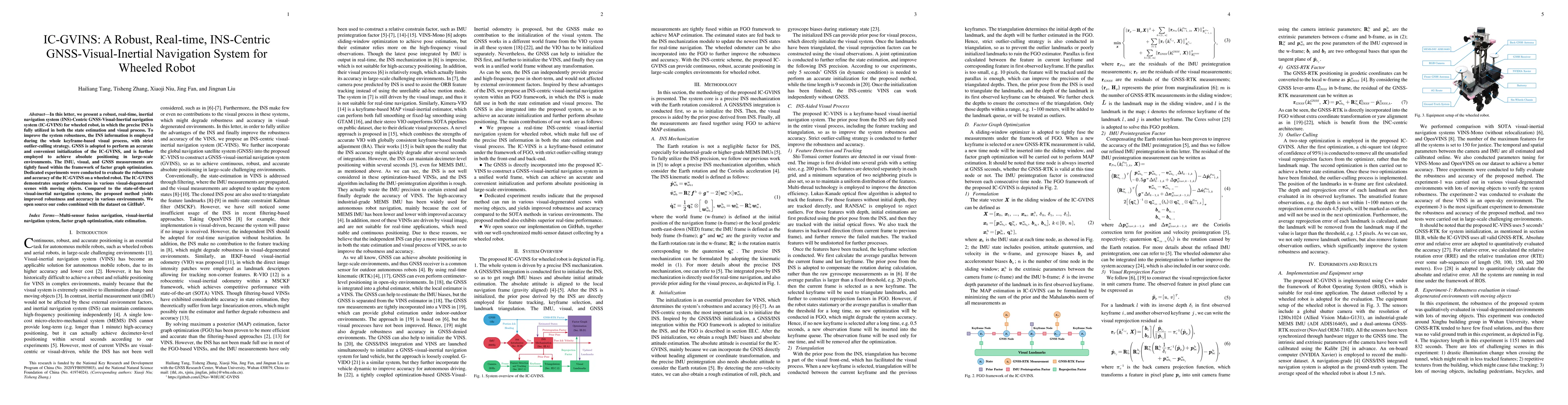
In this letter, we present a robust, real-time, inertial navigation system (INS)-Centric GNSS-Visual-Inertial navigation system (IC-GVINS) for wheeled robot, in which the precise INS is fully utiliz...

Thumbnail for OdoNet: Untethered Speed Aiding for Vehicle Navigation Without Hardware
  Wheeled Odometer
arXiv
OdoNet: Untethered Speed Aiding for Vehicle Navigation Without Hardware Wheeled Odometer

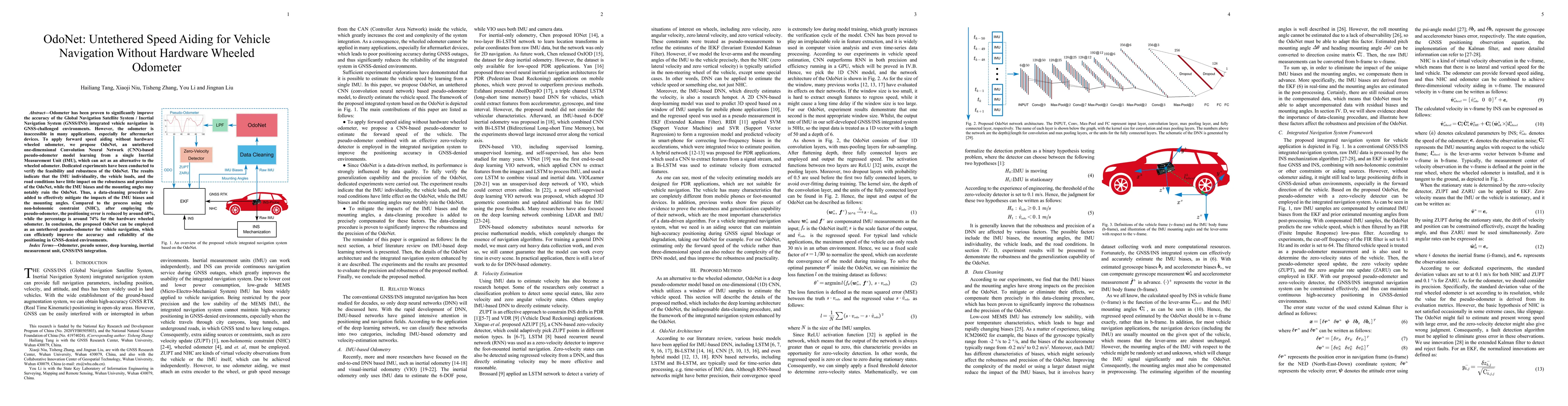
Odometer has been proven to significantly improve the accuracy of the Global Navigation Satellite System / Inertial Navigation System (GNSS/INS) integrated vehicle navigation in GNSS-challenged envi...

Thumbnail for Exploring the Accuracy Potential of IMU Preintegration in Factor Graph
  Optimization
arXiv
Exploring the Accuracy Potential of IMU Preintegration in Factor Graph Optimization

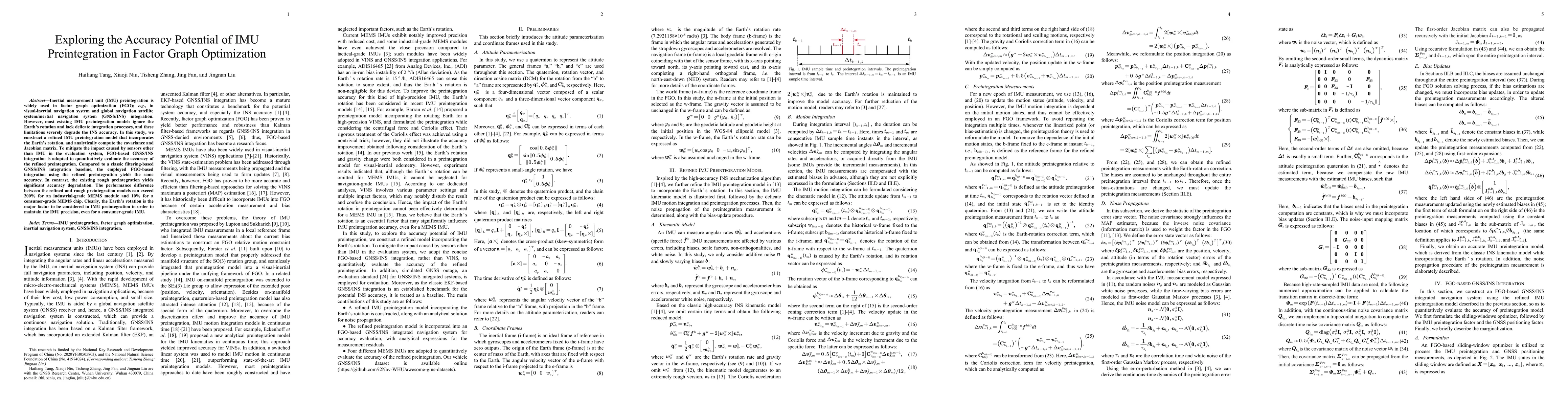
Inertial measurement unit (IMU) preintegration is widely used in factor graph optimization (FGO); e.g., in visual-inertial navigation system and global navigation satellite system/inertial navigatio...

Thumbnail for Wheel-INS2: Multiple MEMS IMU-based Dead Reckoning System for Wheeled
  Robots with Evaluation of Different IMU Configurations
arXiv
Wheel-INS2: Multiple MEMS IMU-based Dead Reckoning System for Wheeled Robots with Evaluation of Different IMU Configurations

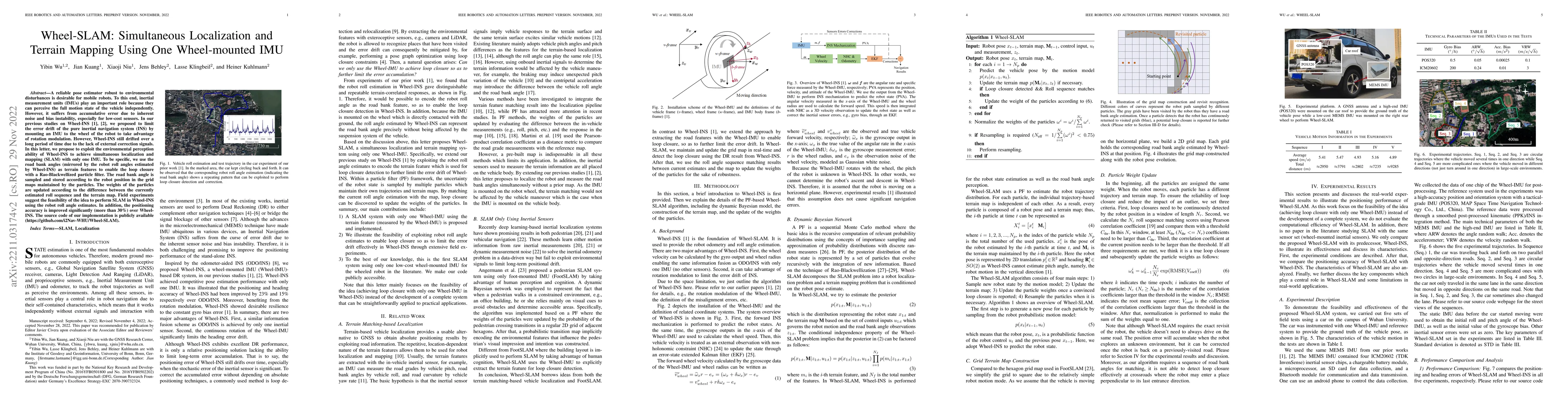
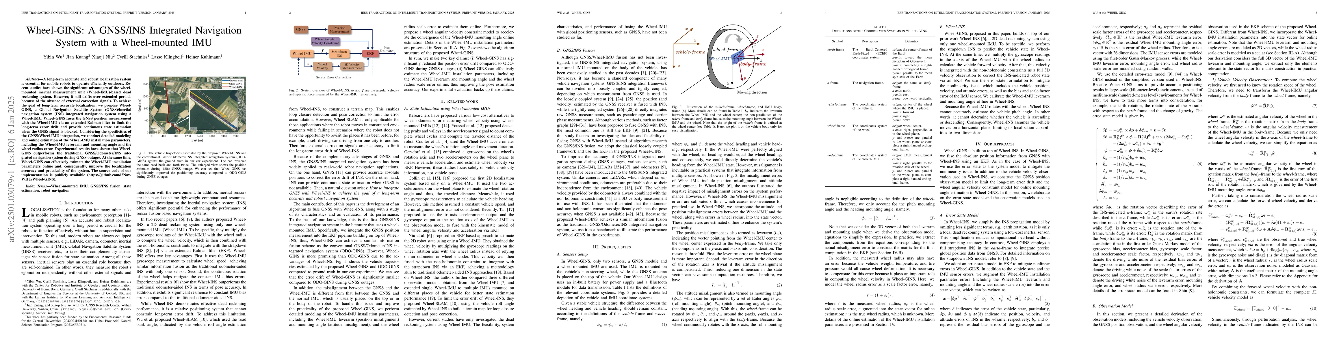
A reliable self-contained navigation system is essential for autonomous vehicles. Based on our previous study on Wheel-INS \cite{niu2019}, a wheel-mounted inertial measurement unit (Wheel-IMU)-based...

Thumbnail for Inertial Sensing Meets Artificial Intelligence: Opportunity or
  Challenge?
arXiv
Inertial Sensing Meets Artificial Intelligence: Opportunity or Challenge?

The inertial navigation system (INS) has been widely used to provide self-contained and continuous motion estimation in intelligent transportation systems. Recently, the emergence of chip-level iner...

Thumbnail for Autonomous Calibration of MEMS Gyros in Consumer Portable Devices
arXiv
Autonomous Calibration of MEMS Gyros in Consumer Portable Devices

This paper presents a real-time calibration method for gyro sensors in consumer portable devices. The calibration happens automatically without the need for external equipment or user intervention. ...

Thumbnail for Location-Enabled IoT (LE-IoT): A Survey of Positioning Techniques, Error
  Sources, and Mitigation
arXiv
Location-Enabled IoT (LE-IoT): A Survey of Positioning Techniques, Error Sources, and Mitigation

The Internet of Things (IoT) has started to empower the future of many industrial and mass-market applications. Localization techniques are becoming key to add location context to IoT data without h...

Thumbnail for Wheel-INS: A Wheel-mounted MEMS IMU-based Dead Reckoning System
arXiv
Wheel-INS: A Wheel-mounted MEMS IMU-based Dead Reckoning System

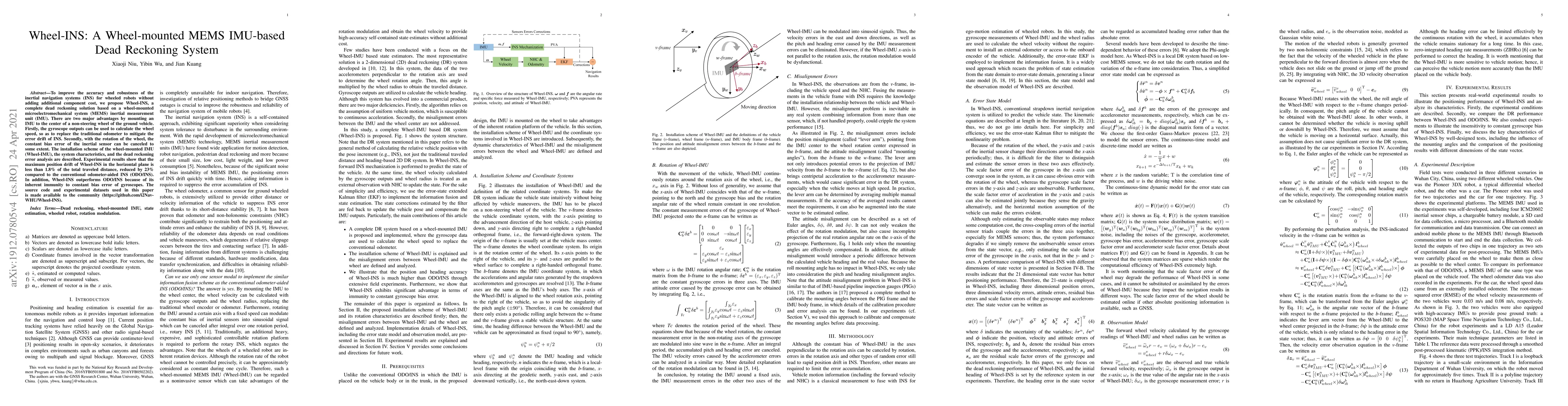
To improve the accuracy and robustness of the inertial navigation systems (INS) for wheeled robots without adding additional component cost, we propose Wheel-INS, a complete dead reckoning solution ...

Thumbnail for MR-ULINS: A Tightly-Coupled UWB-LiDAR-Inertial Estimator with
  Multi-Epoch Outlier Rejection
arXiv
MR-ULINS: A Tightly-Coupled UWB-LiDAR-Inertial Estimator with Multi-Epoch Outlier Rejection

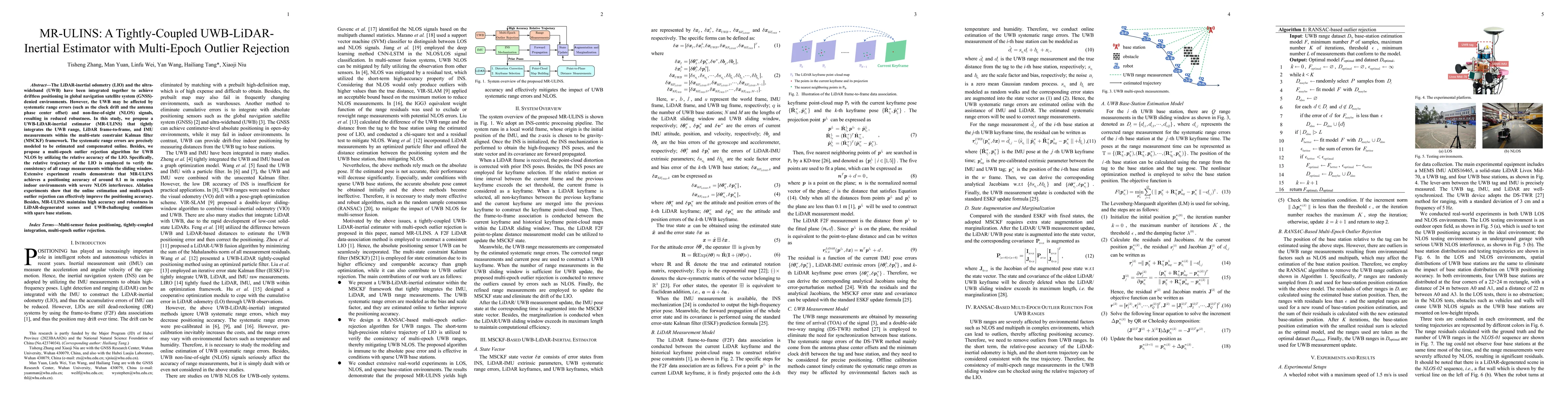
The LiDAR-inertial odometry (LIO) and the ultra-wideband (UWB) have been integrated together to achieve driftless positioning in global navigation satellite system (GNSS)-denied environments. However,...

Thumbnail for Wheel-GINS: A GNSS/INS Integrated Navigation System with a Wheel-mounted
  IMU
arXiv
Wheel-GINS: A GNSS/INS Integrated Navigation System with a Wheel-mounted IMU

A long-term accurate and robust localization system is essential for mobile robots to operate efficiently outdoors. Recent studies have shown the significant advantages of the wheel-mounted inertial m...

Thumbnail for DogLegs: Robust Proprioceptive State Estimation for Legged Robots Using
  Multiple Leg-Mounted IMUs
arXiv
DogLegs: Robust Proprioceptive State Estimation for Legged Robots Using Multiple Leg-Mounted IMUs

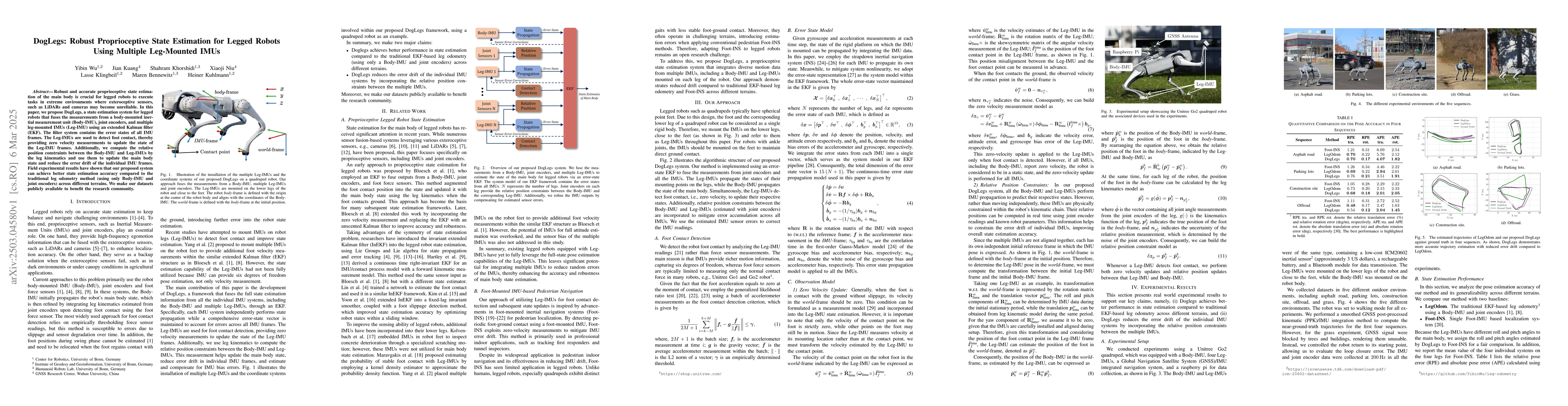
Robust and accurate proprioceptive state estimation of the main body is crucial for legged robots to execute tasks in extreme environments where exteroceptive sensors, such as LiDARs and cameras may b...

Thumbnail for SELC: Self-Supervised Efficient Local Correspondence Learning for Low
  Quality Images
arXiv
SELC: Self-Supervised Efficient Local Correspondence Learning for Low Quality Images

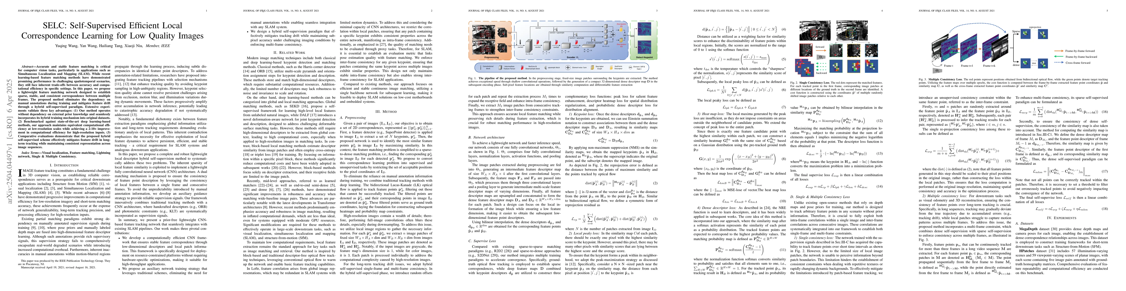
Accurate and stable feature matching is critical for computer vision tasks, particularly in applications such as Simultaneous Localization and Mapping (SLAM). While recent learning-based feature match...

Thumbnail for MSCEKF-MIO: Magnetic-Inertial Odometry Based on Multi-State Constraint
  Extended Kalman Filter
arXiv
MSCEKF-MIO: Magnetic-Inertial Odometry Based on Multi-State Constraint Extended Kalman Filter

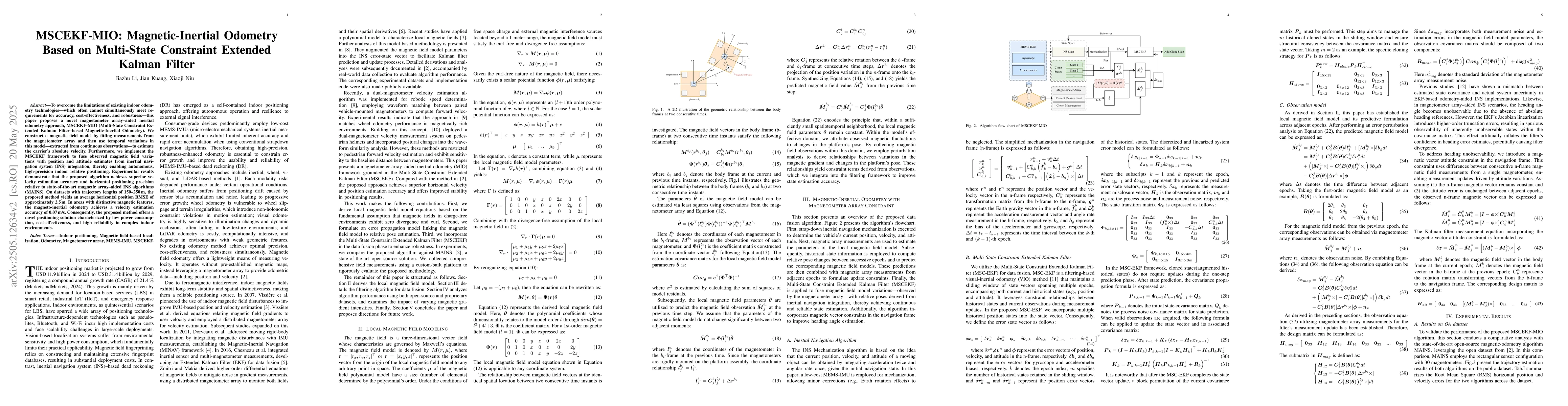
To overcome the limitation of existing indoor odometry technologies which often cannot simultaneously meet requirements for accuracy cost-effectiveness, and robustness-this paper proposes a novel magn...

Thumbnail for MSC-LIO: An MSCKF-Based LiDAR-Inertial Odometry with Same-Plane Cluster
  Tracking
arXiv
MSC-LIO: An MSCKF-Based LiDAR-Inertial Odometry with Same-Plane Cluster Tracking

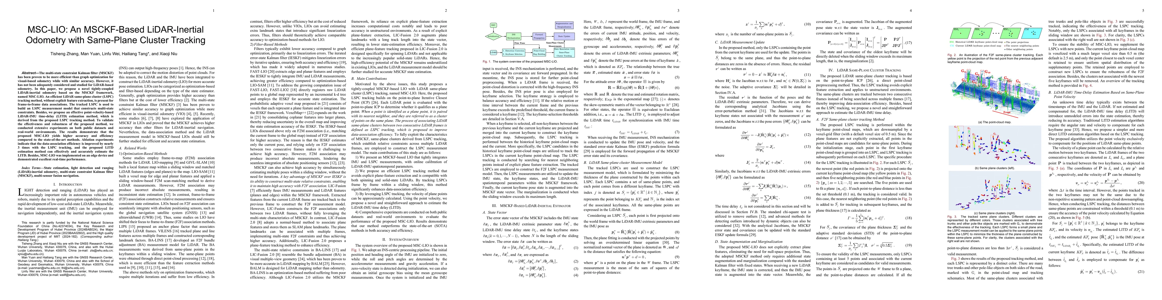
The multi-state constraint Kalman filter (MSCKF) has been proven to be more efficient than graph optimization for visual-based odometry while with similar accuracy. However, it has not been adequately...

Thumbnail for i2Nav-Robot: A Large-Scale Indoor-Outdoor Robot Dataset for Multi-Sensor
  Fusion Navigation and Mapping
arXiv
i2Nav-Robot: A Large-Scale Indoor-Outdoor Robot Dataset for Multi-Sensor Fusion Navigation and Mapping

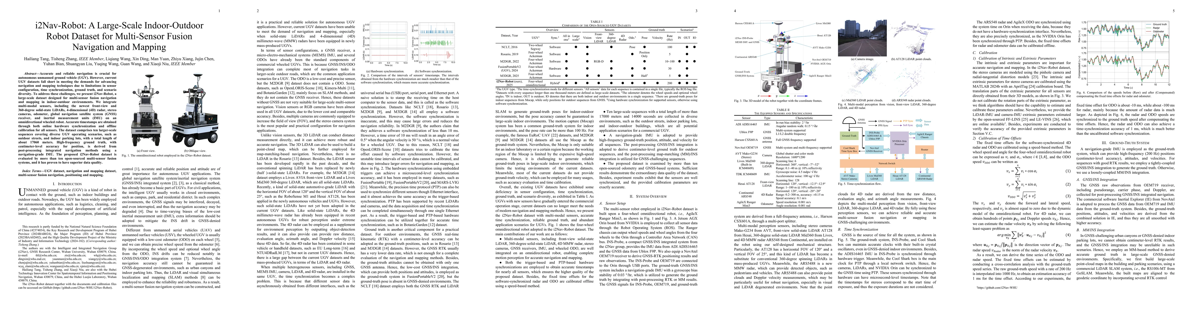
Accurate and reliable navigation is crucial for autonomous unmanned ground vehicle (UGV). However, current UGV datasets fall short in meeting the demands for advancing navigation and mapping technique...

Thumbnail for Learned Inertial Odometry for Cycling Based on Mixture of Experts
  Algorithm
arXiv
Learned Inertial Odometry for Cycling Based on Mixture of Experts Algorithm

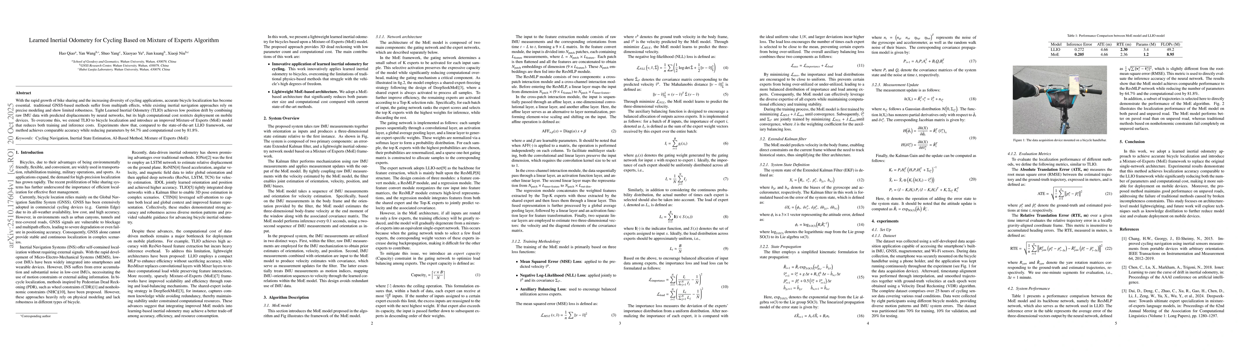
With the rapid growth of bike sharing and the increasing diversity of cycling applications, accurate bicycle localization has become essential. traditional GNSS-based methods suffer from multipath eff...

Thumbnail for PA-LVIO: Real-Time LiDAR-Visual-Inertial Odometry and Mapping with Pose-Only Bundle Adjustment
arXiv
PA-LVIO: Real-Time LiDAR-Visual-Inertial Odometry and Mapping with Pose-Only Bundle Adjustment

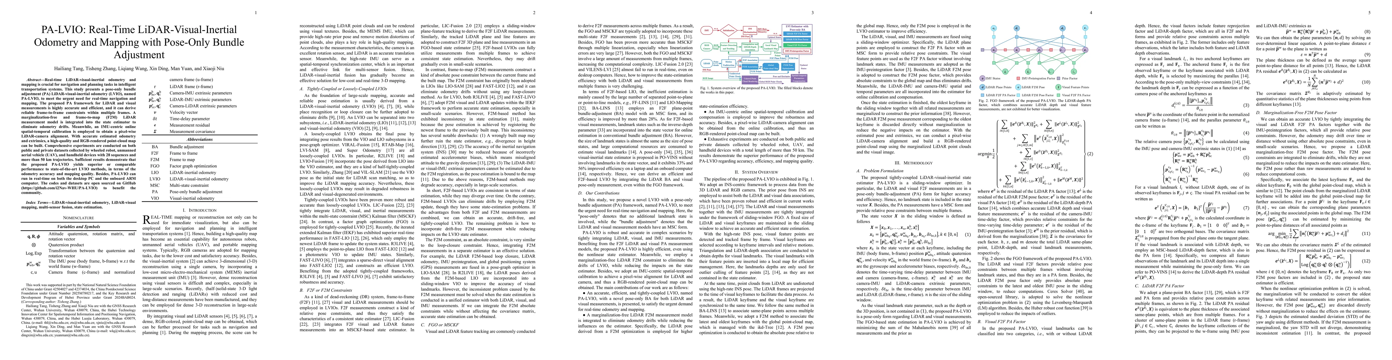
Real-time LiDAR-visual-inertial odometry and mapping is crucial for navigation and planning tasks in intelligent transportation systems. This study presents a pose-only bundle adjustment (PA) LiDAR-vi...

Thumbnail for ViBA: Implicit Bundle Adjustment with Geometric and Temporal Consistency for Robust Visual Matching
arXiv
ViBA: Implicit Bundle Adjustment with Geometric and Temporal Consistency for Robust Visual Matching

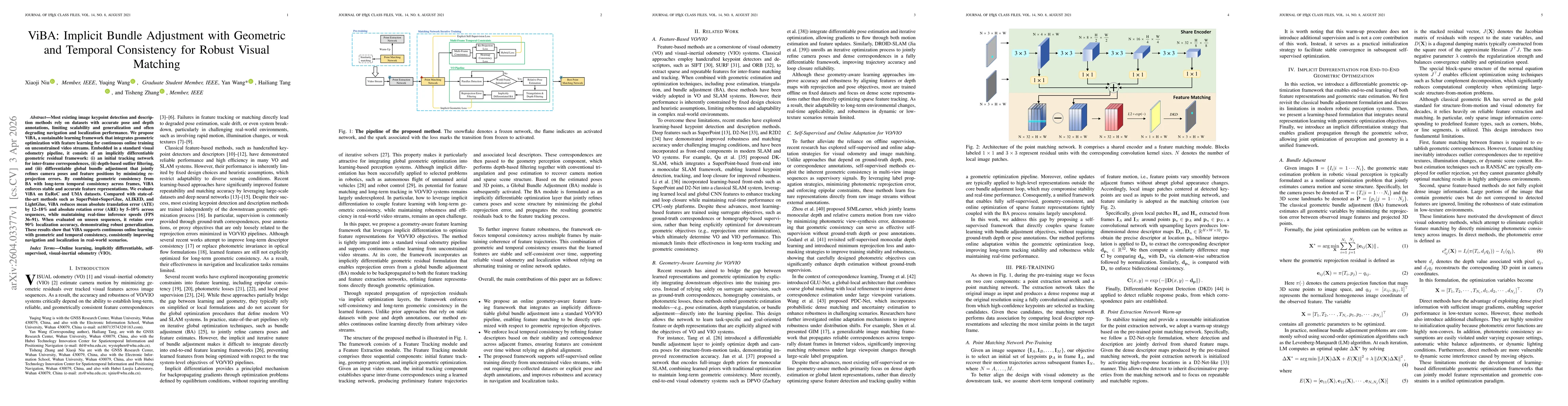
Most existing image keypoint detection and description methods rely on datasets with accurate pose and depth annotations, limiting scalability and generalization, and often degrading navigation and lo...

This website uses cookies to ensure you get the best experience. Learn more