ArxivLens
Y
Researcher

Yifu Tao

12 papers on arXiv

12 arXiv Papers
6 Total Publications
Profile

Academic Profile

Name Tao Yi-fu
Total Papers 6
Scholar Profile View on Semantic Scholar
Metrics

Statistics

12 arXiv Papers
6 Total Publications
Publications

Papers on arXiv

Thumbnail for SiLVR: Scalable Lidar-Visual Reconstruction with Neural Radiance Fields
  for Robotic Inspection
arXiv
SiLVR: Scalable Lidar-Visual Reconstruction with Neural Radiance Fields for Robotic Inspection

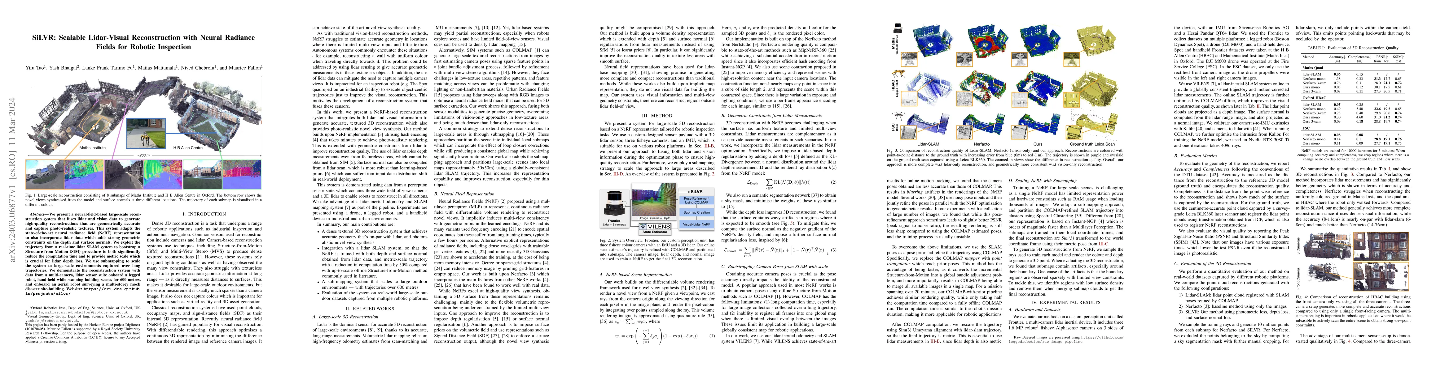
We present a neural-field-based large-scale reconstruction system that fuses lidar and vision data to generate high-quality reconstructions that are geometrically accurate and capture photo-realisti...

Thumbnail for Osprey: Multi-Session Autonomous Aerial Mapping with LiDAR-based SLAM
  and Next Best View Planning
arXiv
Osprey: Multi-Session Autonomous Aerial Mapping with LiDAR-based SLAM and Next Best View Planning

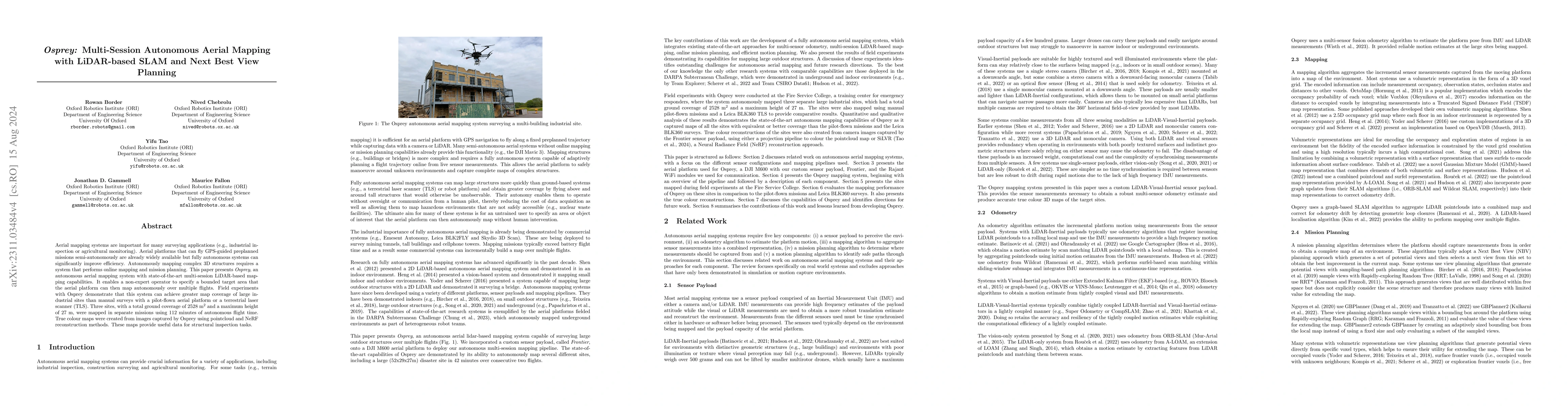
Aerial mapping systems are important for many surveying applications (e.g., industrial inspection or agricultural monitoring). Aerial platforms that can fly GPS-guided preplanned missions semi-auton...

Thumbnail for 3D Lidar Reconstruction with Probabilistic Depth Completion for Robotic
  Navigation
arXiv
3D Lidar Reconstruction with Probabilistic Depth Completion for Robotic Navigation

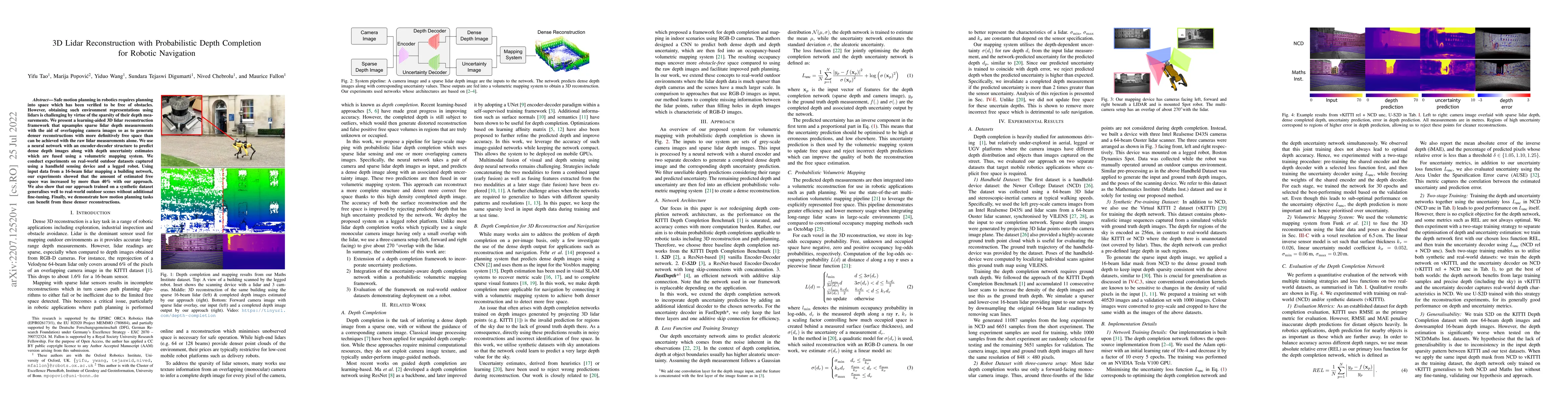
Safe motion planning in robotics requires planning into space which has been verified to be free of obstacles. However, obtaining such environment representations using lidars is challenging by virt...

Thumbnail for Visual Localization in 3D Maps: Comparing Point Cloud, Mesh, and NeRF
  Representations
arXiv
Visual Localization in 3D Maps: Comparing Point Cloud, Mesh, and NeRF Representations

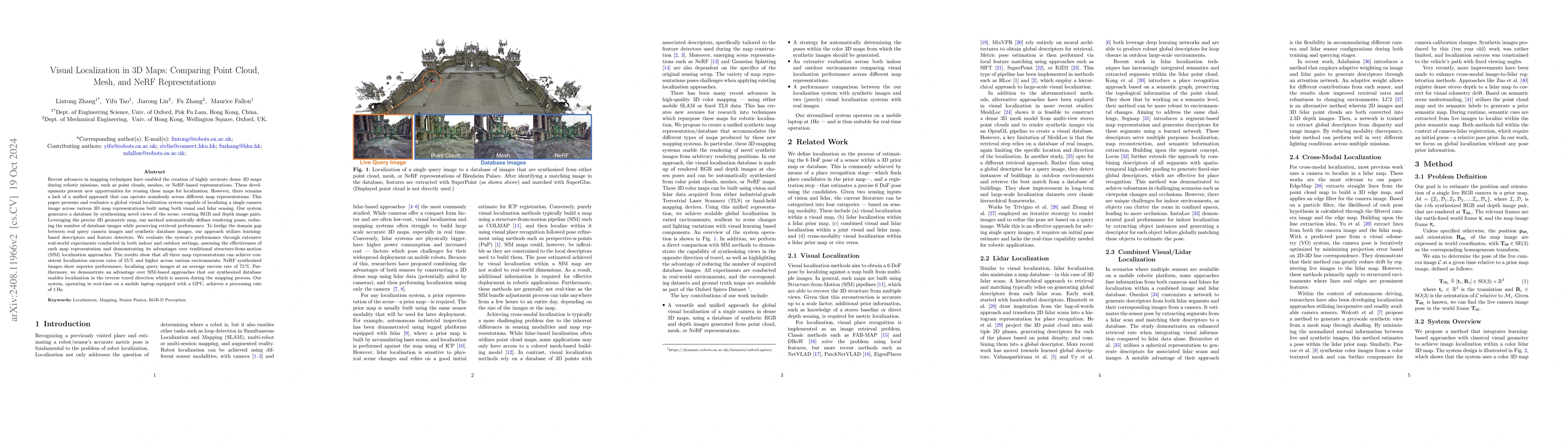
This paper introduces and assesses a cross-modal global visual localization system that can localize camera images within a color 3D map representation built using both visual and lidar sensing. We pr...

Thumbnail for The Oxford Spires Dataset: Benchmarking Large-Scale LiDAR-Visual
  Localisation, Reconstruction and Radiance Field Methods
arXiv
The Oxford Spires Dataset: Benchmarking Large-Scale LiDAR-Visual Localisation, Reconstruction and Radiance Field Methods

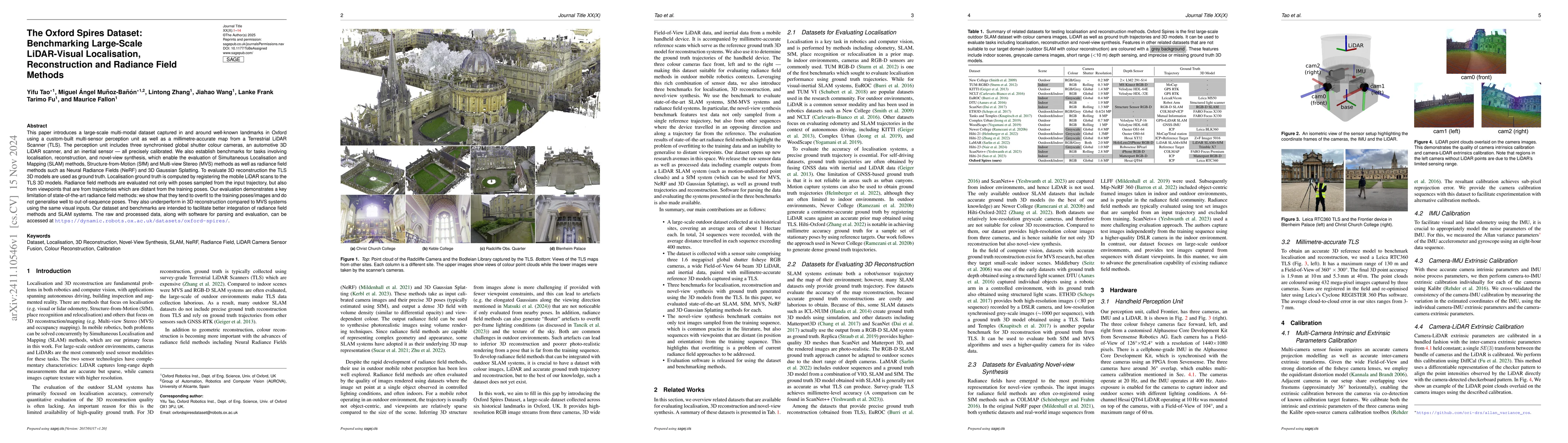
This paper introduces a large-scale multi-modal dataset captured in and around well-known landmarks in Oxford using a custom-built multi-sensor perception unit as well as a millimetre-accurate map fro...

Thumbnail for SiLVR: Scalable Lidar-Visual Radiance Field Reconstruction with
  Uncertainty Quantification
arXiv
SiLVR: Scalable Lidar-Visual Radiance Field Reconstruction with Uncertainty Quantification

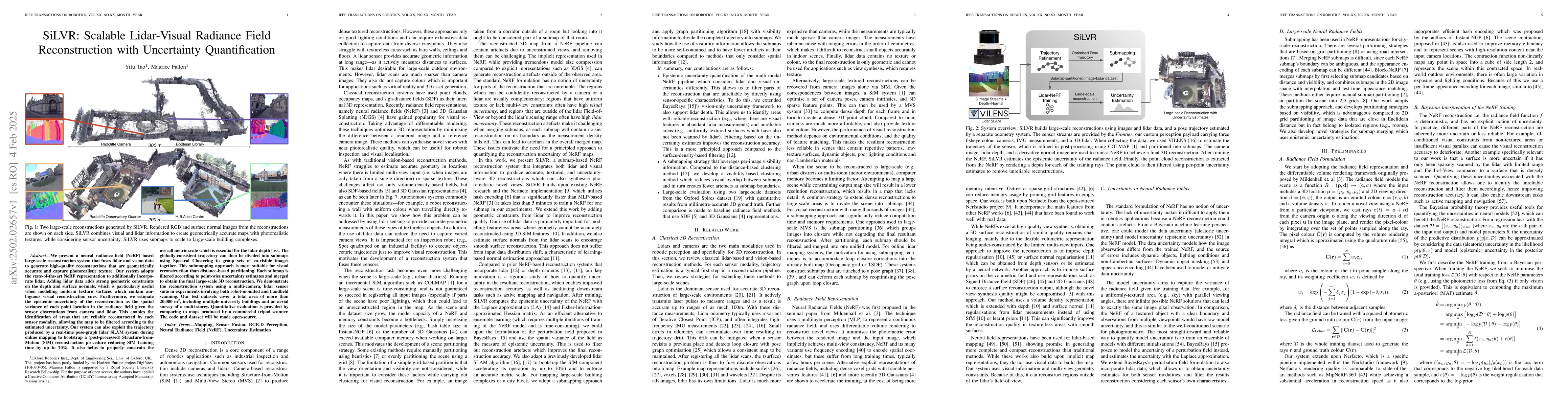
We present a neural radiance field (NeRF) based large-scale reconstruction system that fuses lidar and vision data to generate high-quality reconstructions that are geometrically accurate and capture ...

Thumbnail for Seeing in the Dark: Benchmarking Egocentric 3D Vision with the Oxford
  Day-and-Night Dataset
arXiv
Seeing in the Dark: Benchmarking Egocentric 3D Vision with the Oxford Day-and-Night Dataset

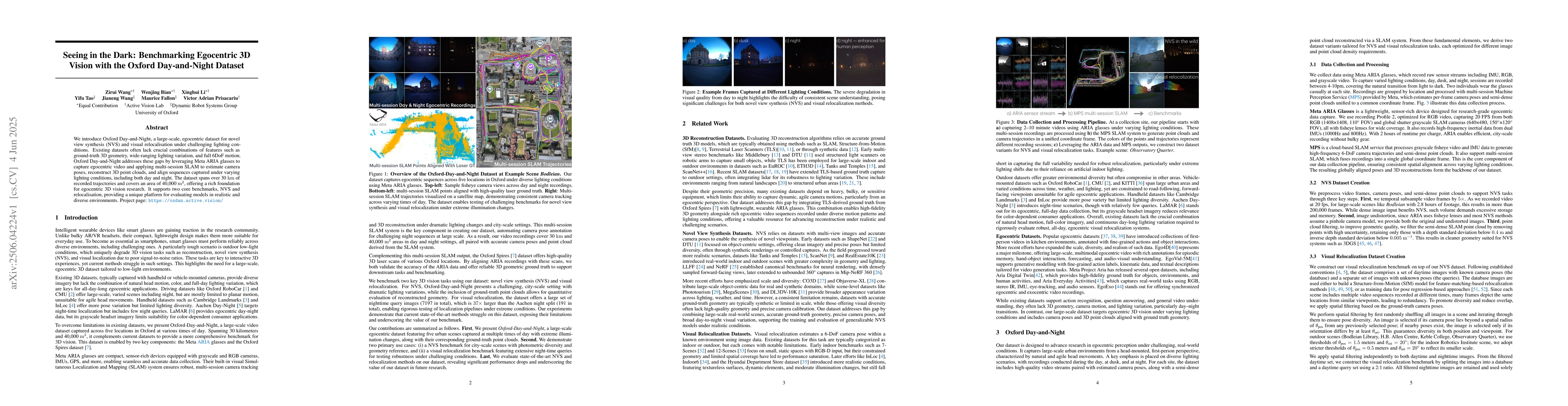
We introduce Oxford Day-and-Night, a large-scale, egocentric dataset for novel view synthesis (NVS) and visual relocalisation under challenging lighting conditions. Existing datasets often lack crucia...

Thumbnail for Neural-MMGS: Multi-modal Neural Gaussian Splats for Large-Scale Scene
  Reconstruction
arXiv
Neural-MMGS: Multi-modal Neural Gaussian Splats for Large-Scale Scene Reconstruction

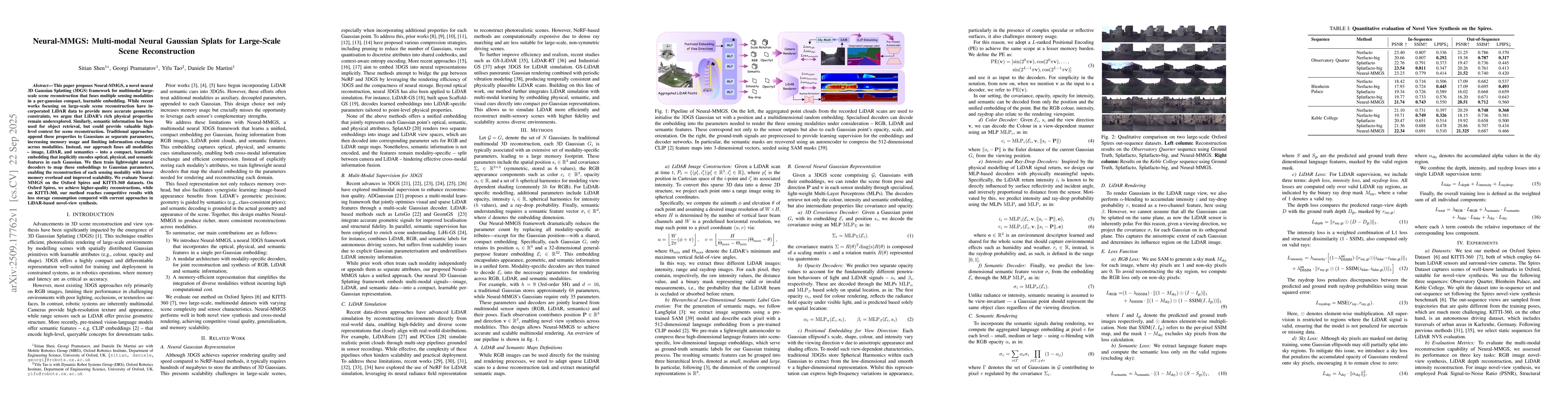
This paper proposes Neural-MMGS, a novel neural 3DGS framework for multimodal large-scale scene reconstruction that fuses multiple sensing modalities in a per-gaussian compact, learnable embedding. Wh...

Thumbnail for PlanarMesh: Building Compact 3D Meshes from LiDAR using Incremental
  Adaptive Resolution Reconstruction
arXiv
PlanarMesh: Building Compact 3D Meshes from LiDAR using Incremental Adaptive Resolution Reconstruction

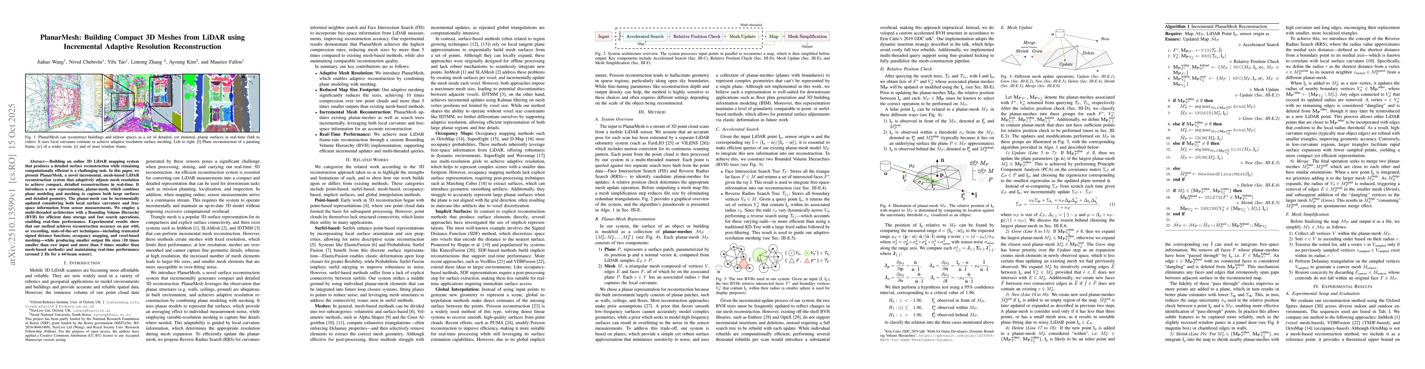
Building an online 3D LiDAR mapping system that produces a detailed surface reconstruction while remaining computationally efficient is a challenging task. In this paper, we present PlanarMesh, a nove...

Thumbnail for Sapling-NeRF: Geo-Localised Sapling Reconstruction in Forests for Ecological Monitoring
arXiv
Sapling-NeRF: Geo-Localised Sapling Reconstruction in Forests for Ecological Monitoring

Saplings are key indicators of forest regeneration and overall forest health. However, their fine-scale architectural traits are difficult to capture with existing 3D sensing methods, which make quant...

Thumbnail for LAPS: Improving Incremental LiDAR Mapping using Active Pooling and Sampling for Neural Distance Fields
arXiv
LAPS: Improving Incremental LiDAR Mapping using Active Pooling and Sampling for Neural Distance Fields

Neural distance fields offer a compact and continuous representation of 3D geometry, making them attractive for incremental LiDAR mapping. However, their online optimization is vulnerable to catastrop...

Thumbnail for ScaRF-SLAM: Scale-Consistent Reconstruction with Feed-Forward Models and Classical Visual SLAM
arXiv
ScaRF-SLAM: Scale-Consistent Reconstruction with Feed-Forward Models and Classical Visual SLAM

Recent works have explored unifying SLAM with geometric foundation models (GFMs). However, directly using GFM predictions for tracking is highly sensitive to model capability and uncertainty, as geome...

This website uses cookies to ensure you get the best experience. Learn more