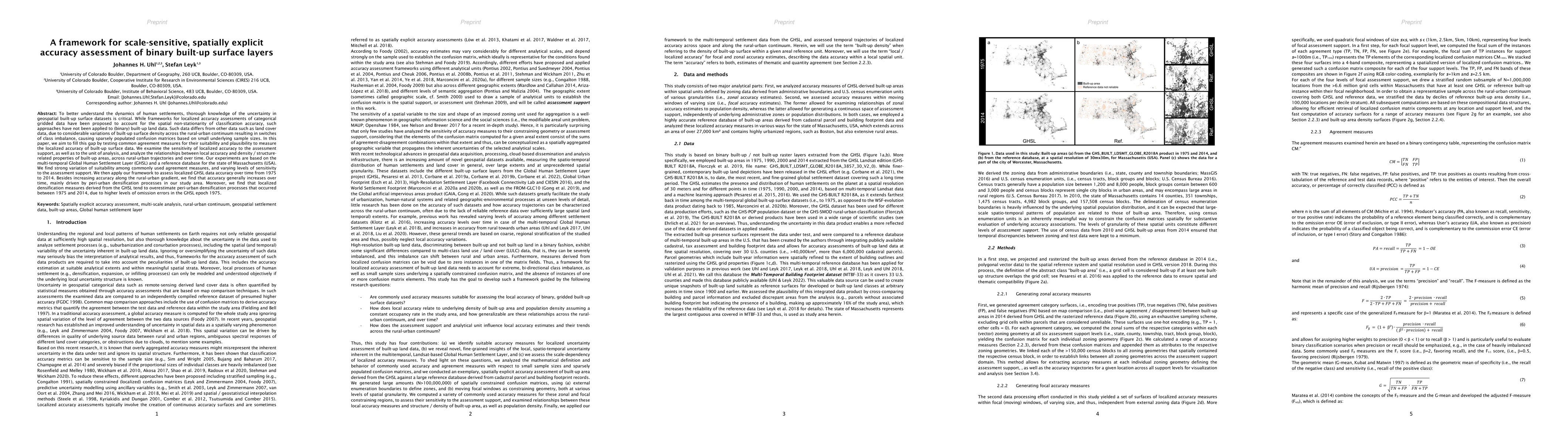
This paper proposes a framework for assessing the localized accuracy of binary built-up surface data, highlighting the variability in accuracy measures and their sensitivity to assessment support. The study finds increasing accuracy over time, driven by peri-urban densification, but notes overestimation of such processes due to higher omission errors in earlier datasets.
To better understand the dynamics of human settlements, thorough knowledge of the uncertainty in geospatial built-up surface datasets is critical. While frameworks for localized accuracy assessments of categorical gridded data have been proposed to account for the spatial non-stationarity of classification accuracy, such approaches have not been applied to (binary) built-up land data. Such data differs from other data such as land cover data, due to considerable variations of built-up surface density across the rural-urban continuum resulting in switches of class imbalance, causing sparsely populated confusion matrices based on small underlying sample sizes. In this paper, we aim to fill this gap by testing common agreement measures for their suitability and plausibility to measure the localized accuracy of built-up surface data. We examine the sensitivity of localized accuracy to the assessment support, as well as to the unit of analysis, and analyze the relationships between local accuracy and density / structure-related properties of built-up areas, across rural-urban trajectories and over time. Our experiments are based on the multi-temporal Global Human Settlement Layer (GHSL) and a reference database for the state of Massachusetts (USA). We find strong variation of suitability among commonly used agreement measures, and varying levels of sensitivity to the assessment support. We then apply our framework to assess localized GHSL data accuracy over time from 1975 to 2014. Besides increasing accuracy along the rural-urban gradient, we find that accuracy generally increases over time, mainly driven by peri-urban densification processes in our study area. Moreover, we find that localized densification measures derived from the GHSL tend to overestimate peri-urban densification processes that occurred between 1975 and 2014, due to higher levels of omission errors in the GHSL epoch 1975.
Get AI-generated insights about this paper's methodology, results, and significance.
Current paper (gray), citations (green), references (blue)
Johannes H. Uhl, Stefan Leyk
Jasper Roe, Mike Perkins, Leon Furze
Title | Authors | Year | Actions |
---|---|---|---|
Assessing the Accuracy and Consistency of Cropland Datasets and Their Influencing Factors on the Tibetan Plateau
|
Fuyao Zhang, Xue Wang, Liangjie Xin, Xiubin Li
|
2025
|
View Paper |
Exploration of the Urbanization Process and Its Impact on Vegetation in 125 Resource-Based Cities in China and Comparison with Other Cities
|
Jiazheng Han, P. Sajadi, Zhenqi Hu, Kaiping Zhou, Shijin Li, Zhanjie Feng, Francesco Pilla
|
2024
|
View Paper |
Advances on the Global Human Settlement Layer by joint assessment of Earth Observation and population survey data
|
M. Pesaresi, Marcello Schiavina, P. Politis, Sérgio Freire, Katarzyna Krasnodebska, Johannes H. Uhl, Alessandra Carioli, C. Corbane, Lewis Dijkstra, P. Florio, H. K. Friedrich, Jing Gao, S. Leyk, Linlin Lu, Luca Maffenini, Ines Mari-Rivero, Michele Melchiorri, V. Syrris, J. V. D. Hoek, T. Kemper
|
2024
|
View Paper |
Class imbalance: A crucial factor affecting the performance of tea plantations mapping by machine learning
|
Yuanjun Xiao, Jingfeng Huang, Wei Weng, Ran Huang, Qi Shao, Chang Zhou, Shengcheng Li
|
2024
|
View Paper |
Dataset of building locations in Poland in the 1970s and 1980s
|
Piotr Szubert, D. Kaim, Jacek Kozak
|
2024
|
View Paper |
Global spatial assessment of potential for new peri-urban forests to combat climate change
|
S. Francini, G. Chirici, L. Chiesi, Paolo Costa, Guido Caldarelli, Stefano Mancuso
|
2024
|
View Paper |
HISDAC-ES: historical settlement data compilation for Spain (1900–2020)
|
Johannes H. Uhl, D. Royé, K. Burghardt, José A. Aldrey Vázquez, Manuel Borobio Sanchiz, S. Leyk
|
2023
|
View Paper |
Mapping Urban Structure Types Based on Remote Sensing Data—A Universal and Adaptable Framework for Spatial Analyses of Cities
|
Andreas Braun, G. Warth, Felix Bachofer, Michael Schultz, V. Hochschild
|
2023
|
View Paper |
China Building Rooftop Area: the first multi-annual (2016–2021) and high-resolution (2.5 m) building rooftop area dataset in China derived with super-resolution segmentation from Sentinel-2 imagery
|
Zeping Liu, Hong Tang, Lin Feng, Siqing Lyu
|
2023
|
View Paper |
TOWARDS A PAN-EU BUILDING FOOTPRINT MAP BASED ON THE HIERARCHICAL CONFLATION OF OPEN DATASETS: THE DIGITAL BUILDING STOCK MODEL - DBSM
|
P. Florio, C. Giovando, K. Goch, M. Pesaresi, P. Politis, A. Martinez
|
2023
|
View Paper |
Spatially explicit accuracy assessment of deep learning-based, fine-resolution built-up land data in the United States
|
Johannes H. Uhl, S. Leyk
|
2023
|
View Paper |
Assessing the relationship between morphology and mapping accuracy of built-up areas derived from global human settlement data
|
Johannes H. Uhl, S. Leyk
|
2022
|
View Paper |
The Impact of Payments for Environmental Services in the Atlantic Forest: A Geospatial Study
|
Ricardo Cerveira, Nágela Bianca do Prado, Gabriela Tonini, Christiano França da Cunha
|
2024
|
View Paper |
O Impacto de Pagamentos de Serviços Ambientais na Mata Atlântica: Um Estudo Geoespacial
|
Ricardo Cerveira, Nágela Bianca do Prado, Gabriela Tonini, Christiano França da Cunha
|
2024
|
View Paper |
Comments (0)