A framework to determine micro-level population figures using spatially disaggregated population estimates
Publication
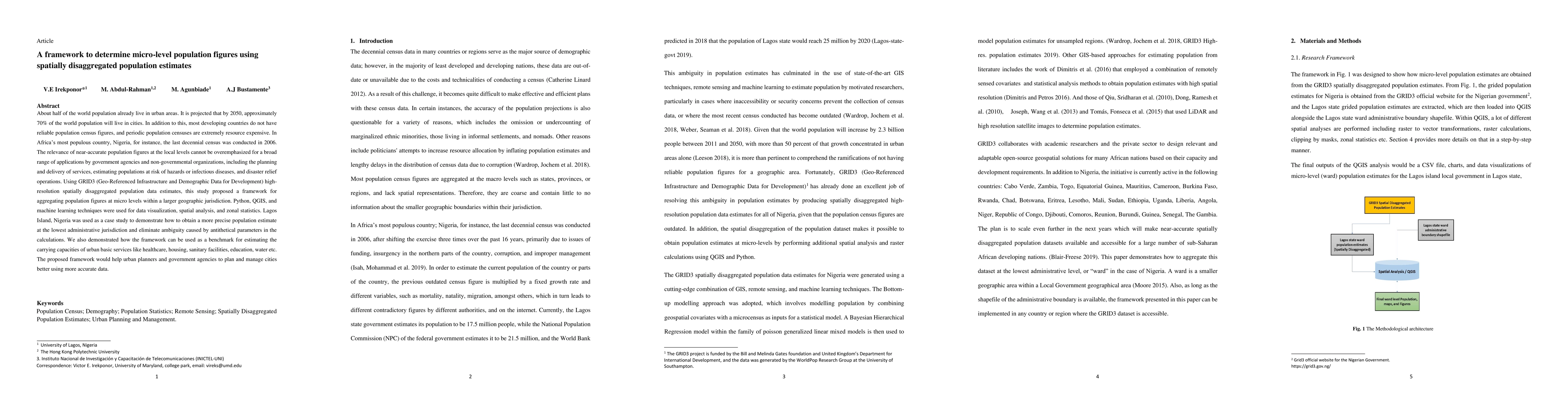
Metrics
AI Quick Summary
This paper proposes a framework for determining precise micro-level population figures using high-resolution spatially disaggregated data, demonstrated through Lagos Island, Nigeria. The framework utilizes Python, QGIS, and machine learning for spatial analysis, aiming to improve urban planning and service delivery by providing near-accurate population estimates.
Paper Preview
Abstract
About half of the world population already live in urban areas. It is projected that by 2050, approximately 70% of the world population will live in cities. In addition to this, most developing countries do not have reliable population census figures, and periodic population censuses are extremely resource expensive. In Africa's most populous country, Nigeria, for instance, the last decennial census was conducted in 2006. The relevance of near-accurate population figures at the local levels cannot be overemphasized for a broad range of applications by government agencies and non-governmental organizations, including the planning and delivery of services, estimating populations at risk of hazards or infectious diseases, and disaster relief operations. Using GRID3 (Geo-Referenced Infrastructure and Demographic Data for Development) high-resolution spatially disaggregated population data estimates, this study proposed a framework for aggregating population figures at micro levels within a larger geographic jurisdiction. Python, QGIS, and machine learning techniques were used for data visualization, spatial analysis, and zonal statistics. Lagos Island, Nigeria was used as a case study to demonstrate how to obtain a more precise population estimate at the lowest administrative jurisdiction and eliminate ambiguity caused by antithetical parameters in the calculations. We also demonstrated how the framework can be used as a benchmark for estimating the carrying capacities of urban basic services like healthcare, housing, sanitary facilities, education, water etc. The proposed framework would help urban planners and government agencies to plan and manage cities better using more accurate data.
AI Key Findings
Get AI-generated insights about this paper's methodology, results, significance, and more — seven facets brought into focus.
Impact
Paper Details
Authors
PDF Preview
Key Terms
Citation Network
Current paper (gray), citations (green), references (blue)
Display is limited for performance on very large graphs.
Discussion 0