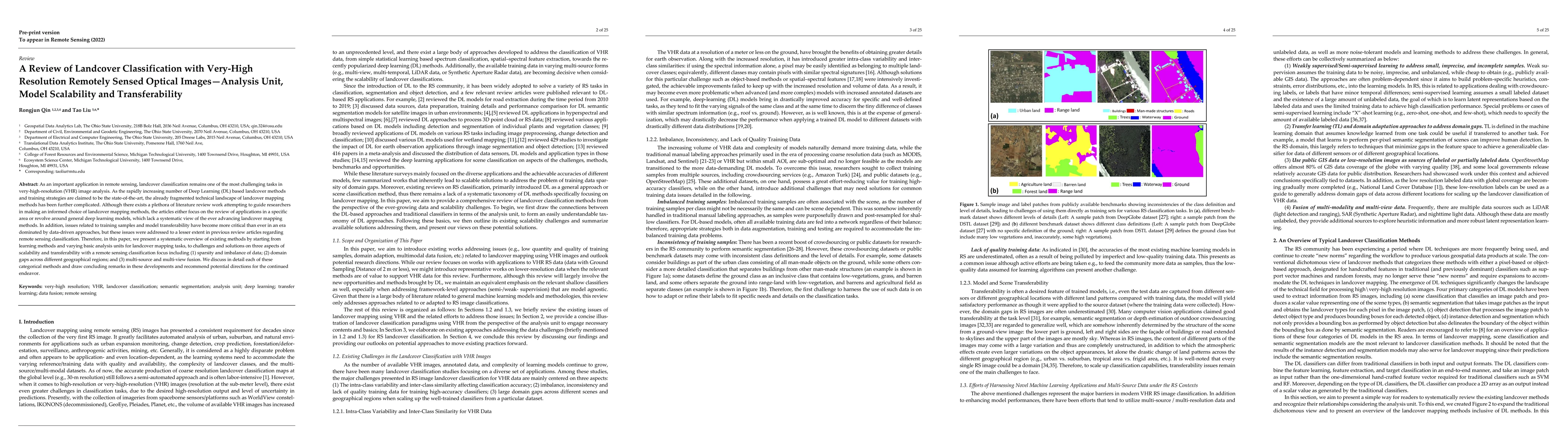
Quick Summary:

This paper provides a systematic review of landcover classification methods using very-high resolution remotely sensed optical images, highlighting scalability and transferability challenges and potential directions for future research.

Summary

As an important application in remote sensing, landcover classification remains one of the most challenging tasks in very-high-resolution (VHR) image analysis. As the rapidly increasing number of Deep Learning (DL) based landcover methods and training strategies are claimed to be the state-of-the-art, the already fragmented technical landscape of landcover mapping methods has been further complicated. Although there exists a plethora of literature review work attempting to guide researchers in making an informed choice of landcover mapping methods, the articles either focus on the review of applications in a specific area or revolve around general deep learning models, which lack a systematic view of the ever advancing landcover mapping methods. In addition, issues related to training samples and model transferability have become more critical than ever in an era dominated by data-driven approaches, but these issues were addressed to a lesser extent in previous review articles regarding remote sensing classification. Therefore, in this paper, we present a systematic overview of existing methods by starting from learning methods and varying basic analysis units for landcover mapping tasks, to challenges and solutions on three aspects of scalability and transferability with a remote sensing classification focus including (1) sparsity and imbalance of data; (2) domain gaps across different geographical regions; and (3) multi-source and multi-view fusion. We discuss in detail each of these categorical methods and draw concluding remarks in these developments and recommend potential directions for the continued endeavor.

AI Key Findings

Get AI-generated insights about this paper's methodology, results, and significance.

Paper Details

PDF Preview

Download PDF

Key Terms

remote sensing (0.247)
remote (0.211)
mapping (0.204)
articles (0.199)
sensing (0.189)
review (0.171)
classification (0.157)
methods (0.155)
deep learning (0.140)
issues (0.138)
systematic (0.137)
view (0.136)
focus (0.122)
multi view (0.119)
learning (0.118)
tasks (0.117)
dl (0.114)
deep (0.114)
training (0.114)
imbalance (0.112)
Title Authors Year Actions
Temporal scalability analysis of spectral remote sensing and Machine Learning-Based models for forest mapping in the tropical region of Nigeria
K. Pawłuszek-Filipiak, D. Włodarczyk, K. Stuchły, F.E. Ikuemonisan
2025
View Paper
A Deep Learning-Based Solution to the Class Imbalance Problem in High-Resolution Land Cover Classification
Pengdi Chen, Yong Liu, Yuanrui Ren, Baoan Zhang, Yuan Zhao
2025
View Paper
Comparison of Machine-Learning Algorithms for SPOT 7 Multispectral Image Classification
Davide Morale, Claudio Parente, Salvatore Falanga Bolognesi
2025
View Paper
Deep learning for efficient high-resolution image processing: A systematic review
Albert Dede, H. Nunoo‐Mensah, E. T. Tchao, A. S. Agbemenu, P. E. Adjei, F. A. Acheampong, J. J. Kponyo
2025
View Paper
Weakly supervised land-cover classification of high-resolution images with low-resolution labels through optimized label refinement
Yang Tang, Guixiang Zhang, Jung-Kuan Liu, Rongjun Qin
2025
View Paper
A Comprehensive Survey of Deep Learning Approaches in Image Processing
M. Trigka, Elias Dritsas
2025
View Paper
How will ai transform urban observing, sensing, imaging, and mapping?
Qihao Weng, Zhiwei Li, Yinxia Cao, Xiaoyan Lu, P. Gamba, Xiaoxia Zhu, Yonghao Xu, Fan Zhang, Rongjun Qin, Micheal. Y. Yang, Peifeng Ma, Wei Huang, Tiangang Yin, Qiming Zheng, Yuhan Zhou, G. Asner
2024
View Paper
Estimating surface water loss using WDI and ECI: a climatological study on different land covers
P. Pasquariello, G. Masiello, Carmine Serio, Vito Telesca, G. Liuzzi, Marco D'Emilio, Rocco Giosa, S. Venafra, I. De Feis, Fabio Della Rocca
2024
View Paper
Assessment of UAV-Based Deep Learning for Corn Crop Analysis in Midwest Brazil
J. Martins, Alberto Yoshiriki Hisano Higuti, A. Pellegrin, R. S. Juliano, Adriana Mello de Araújo, Luiz Alberto Pellegrin, V. Liesenberg, A. P. Ramos, Wesley Nunes Gonçalves, Diego André Sant'Ana, H. Pistori, José Marcato Júnior
2024
View Paper
High-Resolution SAR-to-Multispectral Image Translation Based on S2MS-GAN
Yang Liu, Qingcen Han, Hongwei Yang, Huizhu Hu
2024
View Paper
Despite regional variation, Gymnorhinus cyanocephalus (Pinyon Jay) densities generally increase with local pinyon–juniper cover and heterogeneous ground cover
Nicholas J. Van Lanen, A. Monroe, Cameron L. Aldridge
2024
View Paper
BAMFORESTS: Bamberg Benchmark Forest Dataset of Individual Tree Crowns in Very-High-Resolution UAV Images
Jonas-Dario Troles, Ute Schmid, Wen Fan, Jiaojiao Tian
2024
View Paper
Unsupervised Domain Adaptation Architecture Search with Self-Training for Land Cover Mapping
Clifford Broni-Bediako, Junshi Xia, Naoto Yokoya
2024
View Paper
Analysis of the hyperparameter optimisation of four machine learning satellite imagery classification methods
F. Alonso-Sarría, Carmen Valdivieso-Ros, F. Gomariz-Castillo
2024
View Paper
Multi-Temporal Passive and Active Remote Sensing for Agricultural Mapping and Acreage Estimation in Context of Small Farm Holds in Ethiopia
Tesfamariam Engida Mengesha, L. Desta, P. Gamba, G. Ayehu
2024
View Paper
A novel linear spectral unmixing-based method for tree decline monitoring by fusing UAV-RGB and optical space-borne data
Marziye Ghasemi, Hooman Latifi, Elham Shafeian, Hamed Naghavi, Mehdi Pourhashemi
2024
View Paper
Critical Assessment of Cocoa Classification with Limited Reference Data: A Study in Côte d'Ivoire and Ghana Using Sentinel-2 and Random Forest Model
Nikoletta Moraiti, Adugna G. Mullissa, Eric Rahn, M. Sassen, Johannes Reiche
2024
View Paper
Assisted learning for land use classification: The important role of semantic correlation between heterogeneous images
Wangbin Li, Kaimin Sun, Wenzhuo Li, Xiao Huang, Jinjiang Wei, Yepei Chen, Wei Cui, Xueyu Chen, Xianwei Lv
2024
View Paper
Remote sensing and hydrogeophysics give a new impetus to integrated hydrological models: A review
M. Lubczynski, M. Leblanc, O. Batelaan
2024
View Paper
Rapid Land Cover Classification Using a 36-Year Time Series of Multi-Source Remote Sensing Data
Xin-yan Yan, Jing Li, Andrew R. Smith, Di Yang, Tianyue Ma, Yiting Su
2023
View Paper
SSCNet: A Spectrum-Space Collaborative Network for Semantic Segmentation of Remote Sensing Images
Xin Li, Feng Xu, Xi Yong, Deqing Chen, Runliang Xia, Baoliu Ye, Hongmin Gao, Ziqi Chen, Xin Lyu
2023
View Paper
Learning CRF potentials through fully convolutional networks for satellite image semantic segmentation
Martina Pastorino, G. Moser, S. Serpico, J. Zerubia
2023
View Paper
“Urban-Satellite” estimates in the ABCD Study: Linking Neuroimaging and Mental Health to Satellite Imagery Measurements of Macro Environmental Factors
Ran Goldblatt, N. Holz, Garrett W. Tate, Kari Sherman, Selamawit Ghebremicael, S. Bhuyan, Yazan A. Al-Ajlouni, Sara Santillanes, Ghermay Araya, Shermaine Abad, M. Herting, Wesley K. Thompson, Bishal Thapaliya, Ram Sapkota, Jiayuan Xu, Jingyu Liu, Gunter Schumann, V. Calhoun
2023
View Paper
Modeling future urban network capacity and land use/land cover simulation using GEE and remote sensing data
Muhammad Nabeel Khalid, Muhammad Nasar Ahmad, Muhammad Asif Javed, S. Ahmad
2023
View Paper
Impact of segmentation algorithms on multisensor LULC classification in a semiarid Mediterranean area
Carmen Valdivieso-Ros, F. Alonso-Sarría, F. Gomariz-Castillo
2023
View Paper
GFCNet: Contrastive Learning Network with Geography Feature Space Joint Negative Sample Correction for Land Cover Classification
Zhaoyang Zhang, Wenxuan Jing, Haifeng Li, Chao Tao, Yunsheng Zhang
2023
View Paper
A Comprehensive Review of the Recent Advancement in Integrating Deep Learning with Geographic Information Systems
Asif Raihan
2023
View Paper
Leveraging High-Resolution Long-Wave Infrared Hyperspectral Laboratory Imaging Data for Mineral Identification Using Machine Learning Methods
Alireza Hamedianfar, Kati Laakso, M. Middleton, Tuomo Törmänen, Juha Köykkä, Johanna Torppa
2023
View Paper
A critical survey of GEOBIA methods for forest image detection and classification
Clopas Kwenda, M. V. Gwetu, Fonou-Dombeu Jean Vincent
2023
View Paper
ASSESSMENT OF IMAGE CLASSIFICATION ALGORITHMS FOR LAND COVER CLASSIFICATIONS IN TULLY, NY
A. Poudel, S. Bhatti, E. Bevilacqua
2023
View Paper
Automatic labelling for semantic segmentation of VHR satellite images: Application of airborne laser scanner data and object-based image analysis
Kirsi Karila, L. Matikainen, M. Karjalainen, E. Puttonen, Yuwei Chen, J. Hyyppä
2023
View Paper
An interactive and iterative method for crop mapping through crowdsourcing optimized field samples
Qiangyi Yu, Yulin Duan, Qingying Wu, Yuan Liu, Caiyun Wen, Jianping Qian, Qian Song, Wenjuan Li, Jing Sun, Wenbin Wu
2023
View Paper
FEATURE EXTRACTION USING AT-CONVLSTM BASED CULTURAL ALGORITHM FOR IMAGE UNDERSTANDING
S. Jain, Priya Pise, Akhilesh Mishra
2023
View Paper
Reflections from the Workshop on AI-Assisted Decision Making for Conservation
Lily Xu, Esther Rolf, Sara Beery, J. Bennett, T. Berger-Wolf, Tanya Birch, Elizabeth Bondi-Kelly, J. Brashares, Melissa S. Chapman, Anthony W. Corso, Andrew Davies, Nikhil Garg, A. Gaylard, Robert Heilmayr, H. Kerner, Konstantin Klemmer, Vipin Kumar, Lester W. Mackey, C. Monteleoni, P. Moorcroft, Jonathan Palmer, A. Perrault, D. Thau, M. Tambe
2023
View Paper
Bare Land Referenced Algorithm from Hyper-Temporal Data (BRAH) for Land Use and Land Cover Age Estimation
S. Boonprong, A. Khantachawana
2023
View Paper
Crop Mapping without Labels: Investigating Temporal and Spatial Transferability of Crop Classification Models Using a 5-Year Sentinel-2 Series and Machine Learning
Tomáš Rusňák, T. Kasanický, Peter Malík, J. Mojžiš, J. Zelenka, M. Svicek, Dominik Abrahám, A. Halabuk
2023
View Paper
Advances in Earth observation and machine learning for quantifying blue carbon
T. Pham, N. Ha, N. Saintilan, Andrew Skidmore, Duong Cao Phan, N. N. Le, H. L. Viet, W. Takeuchi, D. Friess
2023
View Paper
The human-elephant conflict in Sri Lanka: history and present status
Thakshila D. Gunawansa, K. Perera, A. Apan, N. Hettiarachchi
2023
View Paper
Assessing Transferability of Remote Sensing Pasture Estimates Using Multiple Machine Learning Algorithms and Evaluation Structures
Hunter D. Smith, J. Dubeux, Alina Zare, Chris H. Wilson
2023
View Paper
A comparison between Pixel-based deep learning and Object-based image analysis (OBIA) for individual detection of cabbage plants based on UAV Visible-light images
Zhangxi Ye, Kaile Yang, Yuwei Lin, Shijie Guo, Yiming Sun, Xunlong Chen, Riwen Lai, Houxi Zhang
2023
View Paper
Integrating Multiple Sources Knowledge for Class Asymmetry Domain Adaptation Segmentation of Remote Sensing Images
Kuiliang Gao, Anzhu Yu, Xiong You, Wenyue Guo, Ke Li, Ningbo Huang
2023
View Paper
Pre-processing training data improves accuracy and generalisability of convolutional neural network based landscape semantic segmentation
A. Clark, S. Phinn, P. Scarth
2023
View Paper
The Accuracy of Land Use and Cover Mapping across Time in Environmental Disaster Zones: The Case of the B1 Tailings Dam Rupture in Brumadinho, Brazil
Carlos Roberto Mangussi Filho, Renato Farias do Valle Junior, Maytê Maria Abreu Pires de Melo Silva, Rafaella Gouveia Mendes, Glauco de Souza Rolim, T. Pissarra, Marília Carvalho de Melo, C. Valera, F. Pacheco, L. Fernandes
2023
View Paper
Combining Deep Learning and Multi-Source GIS Methods to Analyze Urban and Greening Changes
M. Francini, C. Salvo, A. Vitale
2023
View Paper
DMAU-Net: An Attention-Based Multiscale Max-Pooling Dense Network for the Semantic Segmentation in VHR Remote-Sensing Images
Y. Yang, Junwu Dong, Yanhui Wang, Bibo Yu, Zhigang Yang
2023
View Paper
CTFuseNet: A Multi-Scale CNN-Transformer Feature Fused Network for Crop Type Segmentation on UAV Remote Sensing Imagery
Jianjian Xiang, Jia Liu, Du Chen, Qi Xiong, Chongjiu Deng
2023
View Paper
Transformers for mapping burned areas in Brazilian Pantanal and Amazon with PlanetScope imagery
D. Gonçalves, J. M. Junior, A. C. Carrilho, Plabiany Rodrigo Acosta, A. P. Ramos, Felipe David Georges Gomes, L. Osco, M. Oliveira, J. Martins, Geraldo Alves Damasceno Júnior, Márcio Santos Araújo, Jonathan Li, Fábio Roque, L. Peres, W. Gonçalves, R. Libonati
2023
View Paper
Geospatial-based machine learning techniques for land use and land cover mapping using a high-resolution unmanned aerial vehicle image
Taposh Mollick, M. Azam, Sabrina Karim
2022
View Paper
A Framework Integrating DeeplabV3+, Transfer Learning, Active Learning, and Incremental Learning for Mapping Building Footprints
Zhichao Li, Jinwei Dong
2022
View Paper
Land Use and Land Cover Mapping Using Deep Learning Based Segmentation Approaches and VHR Worldview-3 Images
Elif Sertel, Burak Ekim, P. Ettehadi Osgouei, M. E. Kabadayı
2022
View Paper
The Eyes of the Gods: A Survey of Unsupervised Domain Adaptation Methods Based on Remote Sensing Data
Mengqiu Xu, Ming Wu, Kaixin Chen, Chuang Zhang, Jun Guo
2022
View Paper
Migratable urban street scene sensing method based on vision language pre-trained model
Yan Zhang, Fan Zhang, Nengcheng Chen
2022
View Paper
An Ultra-Resolution Features Extraction Suite for Community-Level Vegetation Differentiation and Mapping at a Sub-Meter Resolution
Ram C. Sharma
2022
View Paper
Anthropogenic Land Use and Land Cover Changes—A Review on Its Environmental Consequences and Climate Change
P. Roy, R. Ramachandran, Oscar Paul, P. Thakur, S. Ravan, M. D. Behera, C. Sarangi, V. Kanawade
2022
View Paper
Evaluation of Different Satellite Images for Urban Land Use Analysis: A Case Study of Greater Manchester, United Kingdom
Rukevwe Aliogo, F. Anyiam
2022
View Paper
A Review on Rainfall Measurement Based on Commercial Microwave Links in Wireless Cellular Networks
Bin Lian, Zhongcheng Wei, Xiang Sun, Zhihua Li, Jijun Zhao
2022
View Paper
Self-supervised Audiovisual Representation Learning for Remote Sensing Data
Konrad Heidler, Lichao Mou, Di Hu, P. Jin, Guangyao Li, Chuang Gan, Ji-rong Wen, Xiao Xiang Zhu
2021
View Paper
Simulating urban expansion scenario by Logistic regression (LR) with CA-Markov chain Model for Bhanjanagar town (Odisha, India)
Sanu Dolui
2024
View Paper
CRFNet: A Deep Convolutional Network to Learn the Potentials of a CRF for the Semantic Segmentation of Remote Sensing Images
Martina Pastorino, G. Moser, S. Serpico, J. Zerubia
2024
View Paper
CLIM-SEG: A generalizable segmentation model for heat and flood risk mapping
Anushka Ray, Katherine Xu, Norhan Bayomi, John E. Fernandez
2024
View Paper
High-Resolution Remote Sensing Image Segmentation With Global-Guided Normalization and Local Affinity Distillation
Peng Zhu, Xiangrong Zhang, Xiao Han, Puhua Chen, Xu Tang, Xina Cheng, Licheng Jiao
2024
View Paper
Artificial intelligence to advance Earth observation: a perspective
D. Tuia, K. Schindler, B. Demir, Gustau Camps-Valls, Xiao Xiang Zhu, M. Kochupillai, Savso Dvzeroski, J. N. Rijn, H. Hoos, F. Frate, M. Datcu, Jorge-Arnulfo Quian'e-Ruiz, V. Markl, B. L. Saux, Rochelle Schneider
2023
View Paper
Rapid Land Cover Classification Using a 36-Year Time Series of Multi-Source Remote Sensing Data
C. Serio, G. Masiello, S. Venafra, Xin-yan Yan, Jing Li, Andrew R. Smith, Di Yang, Tianyue Ma, Yiting Su
View Paper
Weakly supervised land-cover classification of high-resolution images with low-resolution labels through optimized label refinement
Yang Tang, Guixiang Zhang, Jung-Kuan Liu, Rongjun Qin
View Paper

Comments (0)

This website uses cookies to ensure you get the best experience. Learn more