Academic Profile
Statistics
Similar Authors
Papers on arXiv
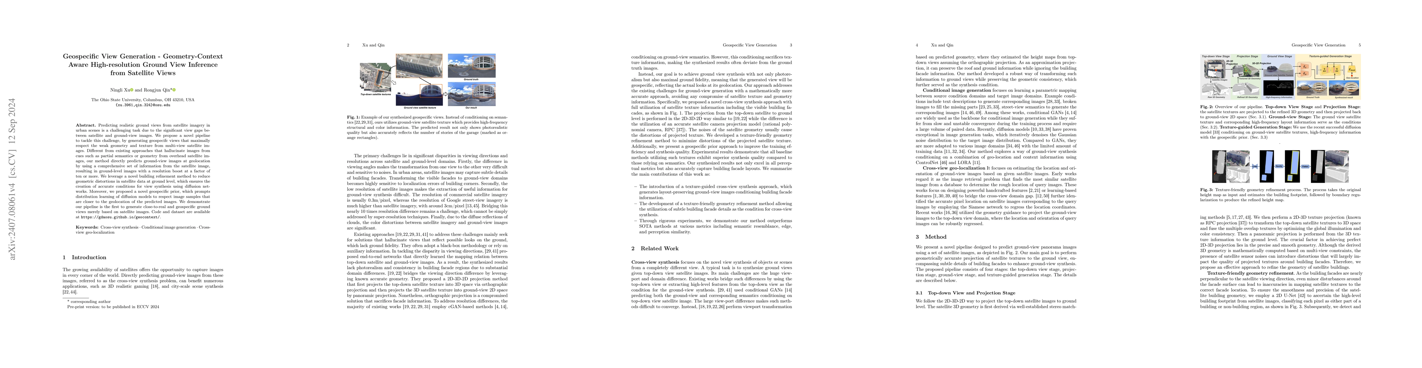
Predicting realistic ground views from satellite imagery in urban scenes is a challenging task due to the significant view gaps between satellite and ground-view images. We propose a novel pipeline to...
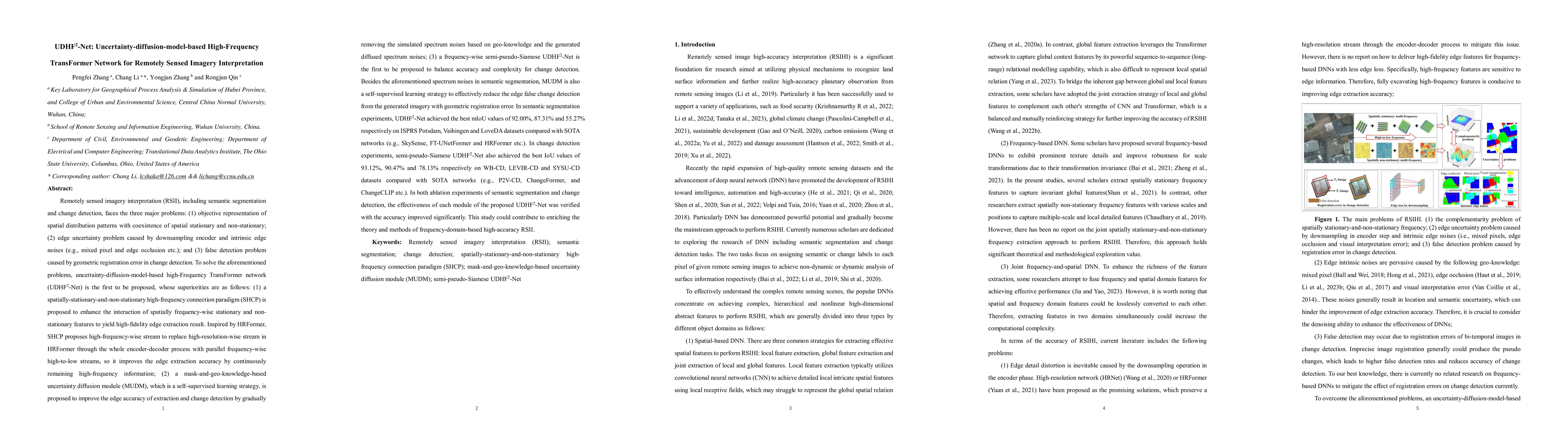
Remotely sensed image high-accuracy interpretation (RSIHI), including tasks such as semantic segmentation and change detection, faces the three major problems: (1) complementarity problem of spatially...
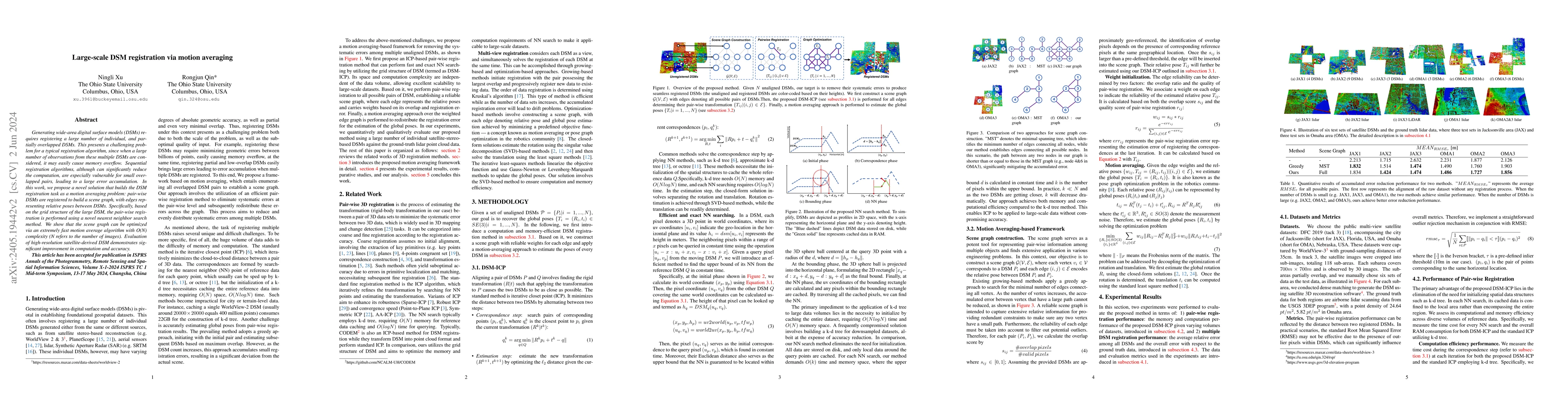
Generating wide-area digital surface models (DSMs) requires registering a large number of individual, and partially overlapped DSMs. This presents a challenging problem for a typical registration al...
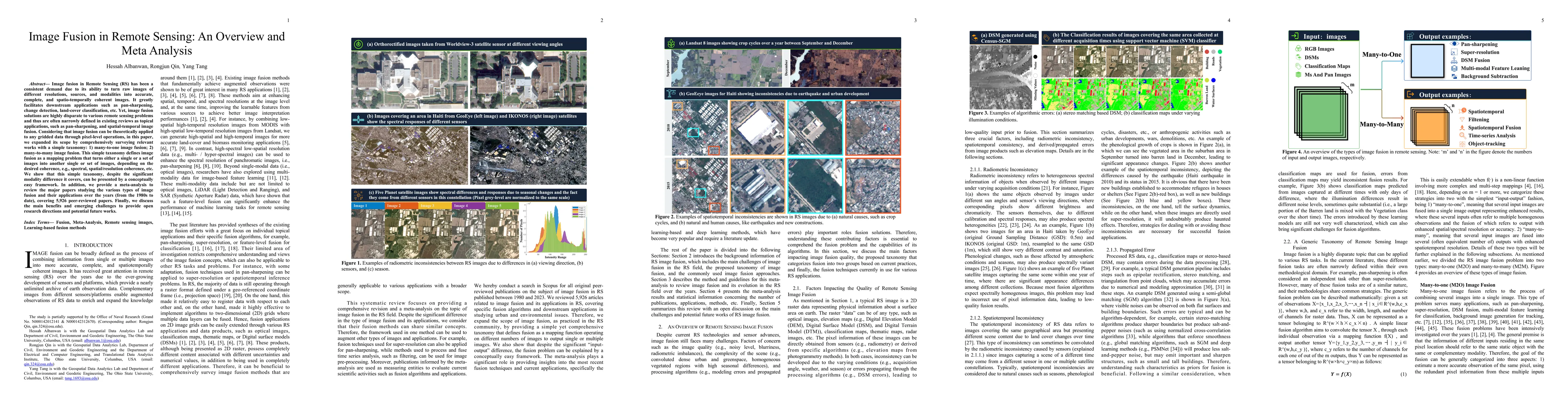
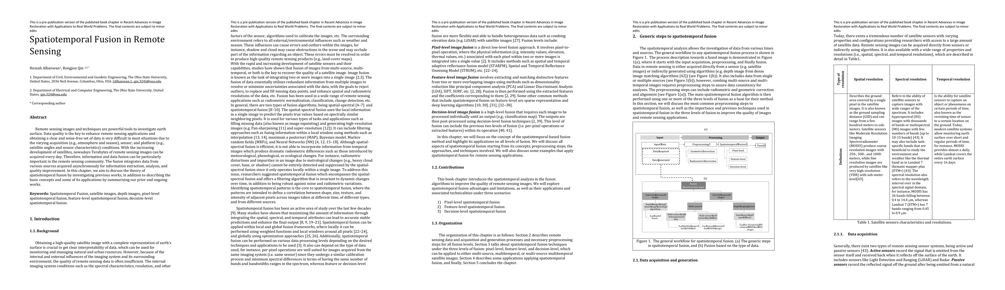
Image fusion in Remote Sensing (RS) has been a consistent demand due to its ability to turn raw images of different resolutions, sources, and modalities into accurate, complete, and spatio-temporall...
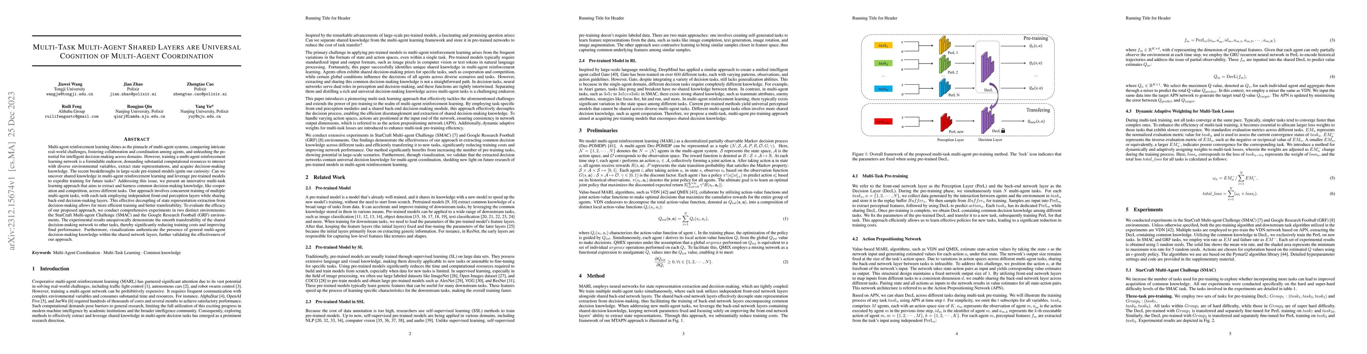
Multi-agent reinforcement learning shines as the pinnacle of multi-agent systems, conquering intricate real-world challenges, fostering collaboration and coordination among agents, and unleashing th...
Recent deep learning-based methods outperform traditional learning methods on remote sensing (RS) semantic segmentation/classification tasks. However, they require large training datasets and are ge...
Neural Radiance Fields (NeRF) offer the potential to benefit 3D reconstruction tasks, including aerial photogrammetry. However, the scalability and accuracy of the inferred geometry are not well-doc...
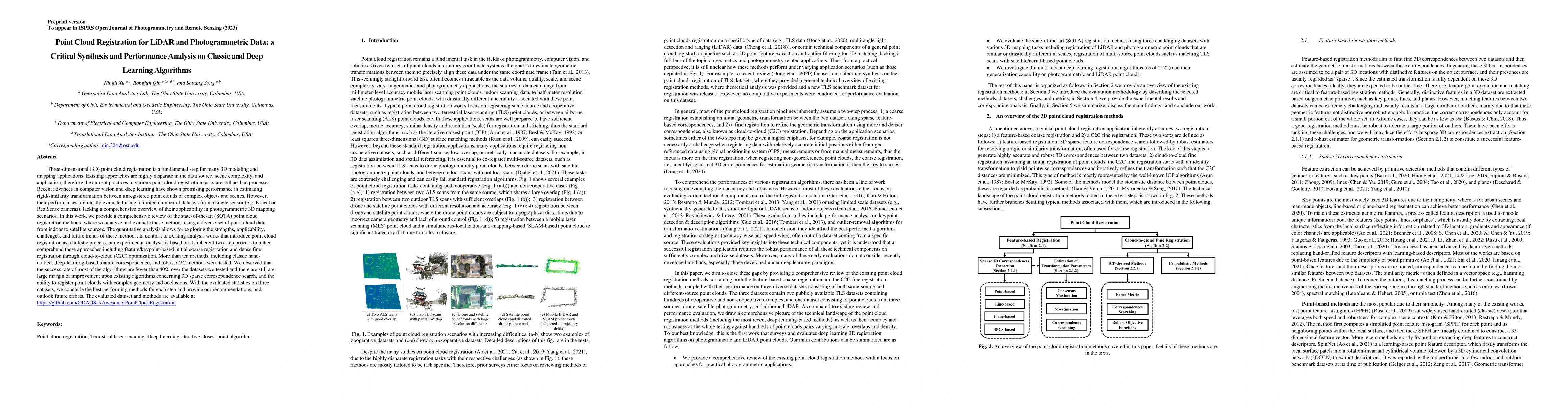
Nowadays, photogrammetrically derived point clouds are widely used in many civilian applications due to their low cost and flexibility in acquisition. Typically, photogrammetric point clouds are ass...
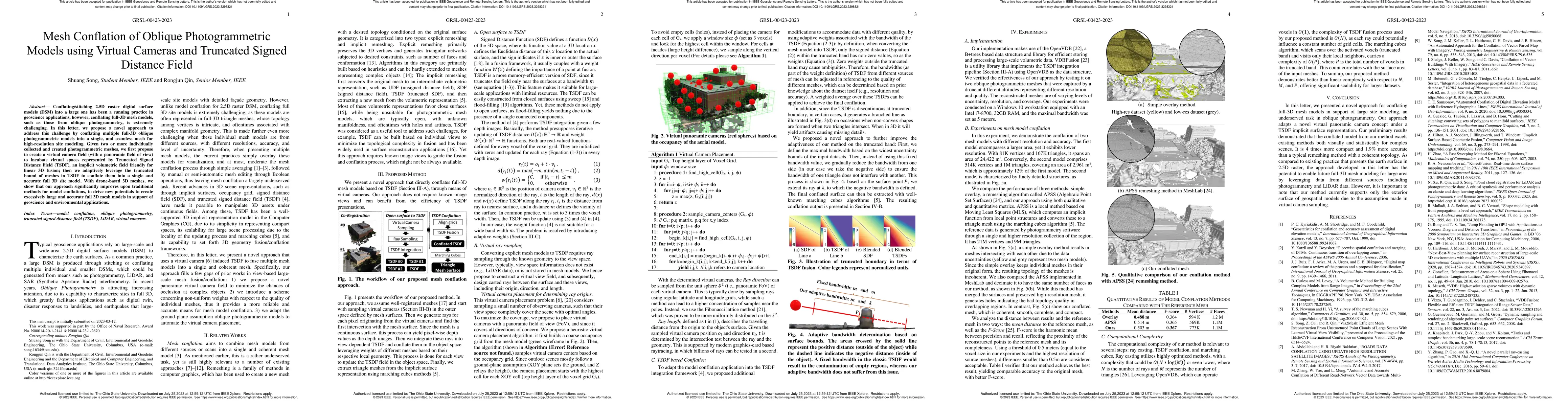
Conflating/stitching 2.5D raster digital surface models (DSM) into a large one has been a running practice in geoscience applications, however, conflating full-3D mesh models, such as those from obl...
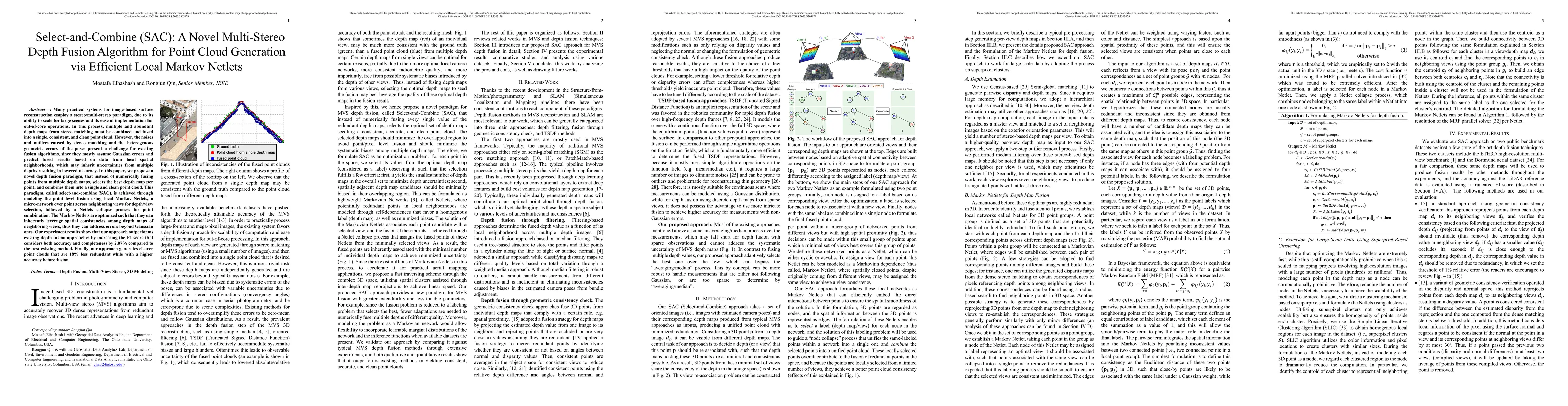
Many practical systems for image-based surface reconstruction employ a stereo/multi-stereo paradigm, due to its ability to scale for large scenes and its ease of implementation for out-of-core opera...
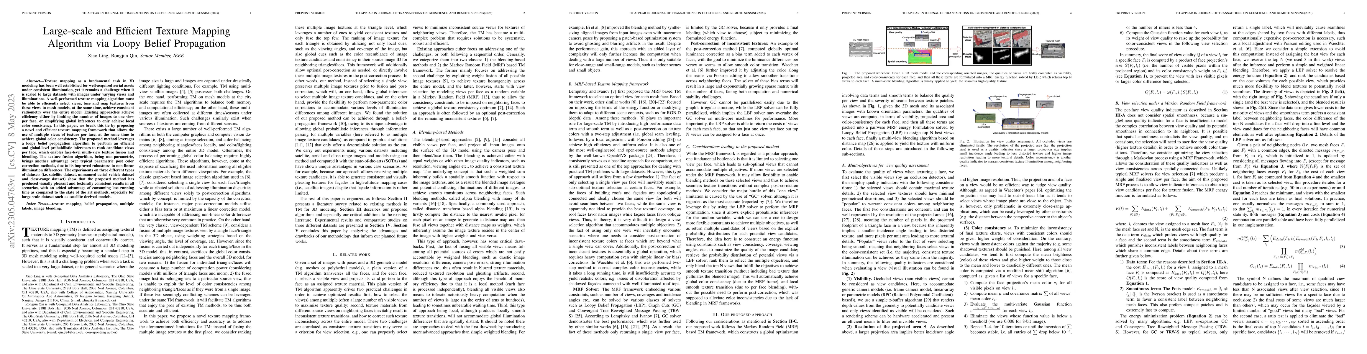
Texture mapping as a fundamental task in 3D modeling has been well established for well-acquired aerial assets under consistent illumination, yet it remains a challenge when it is scaled to large da...
Recent advances in computer vision and deep learning have shown promising performance in estimating rigid/similarity transformation between unregistered point clouds of complex objects and scenes. H...
Deep learning (DL) stereo matching methods gained great attention in remote sensing satellite datasets. However, most of these existing studies conclude assessments based only on a few/single stereo...
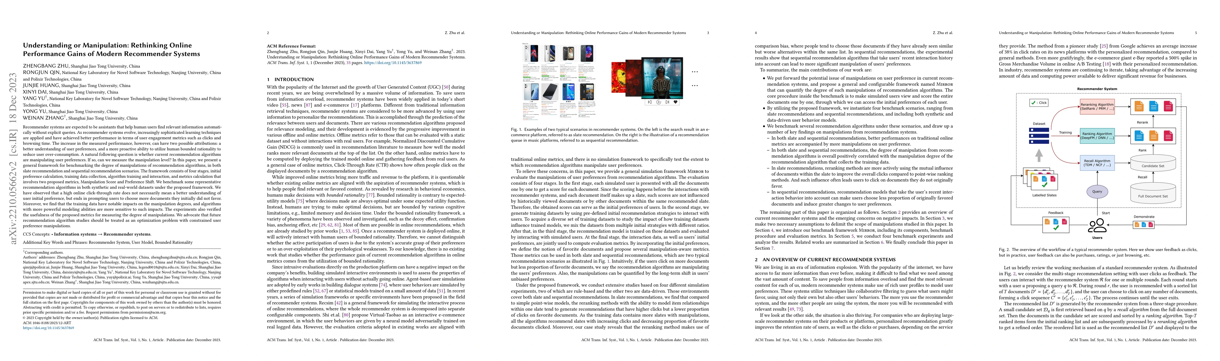
Recommender systems are expected to be assistants that help human users find relevant information automatically without explicit queries. As recommender systems evolve, increasingly sophisticated le...
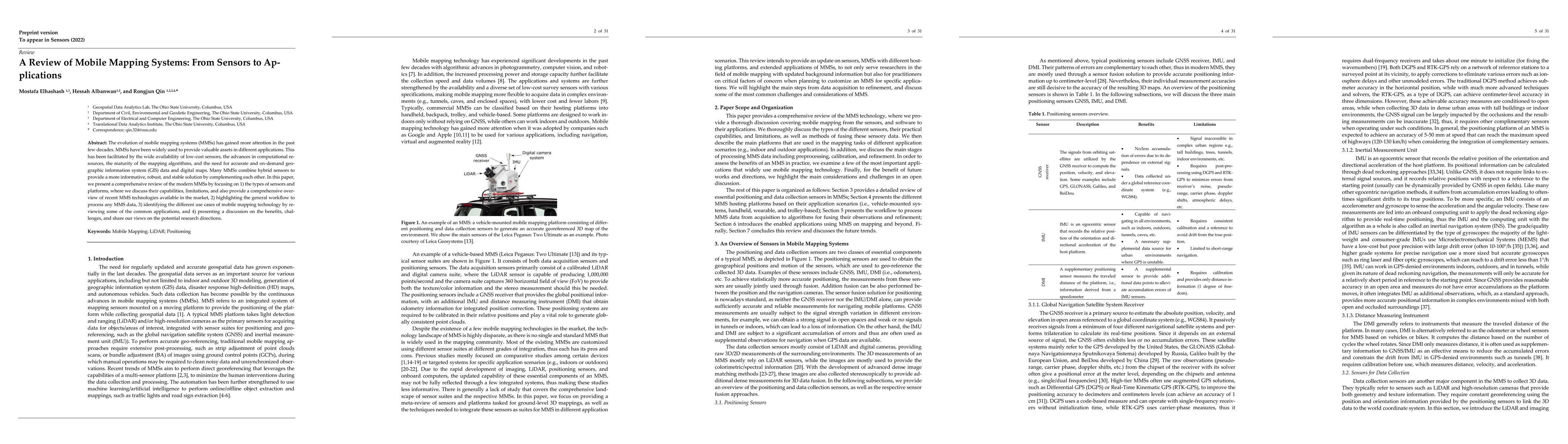
The evolution of mobile mapping systems (MMSs) has gained more attention in the past few decades. MMSs have been widely used to provide valuable assets in different applications. This has been facil...
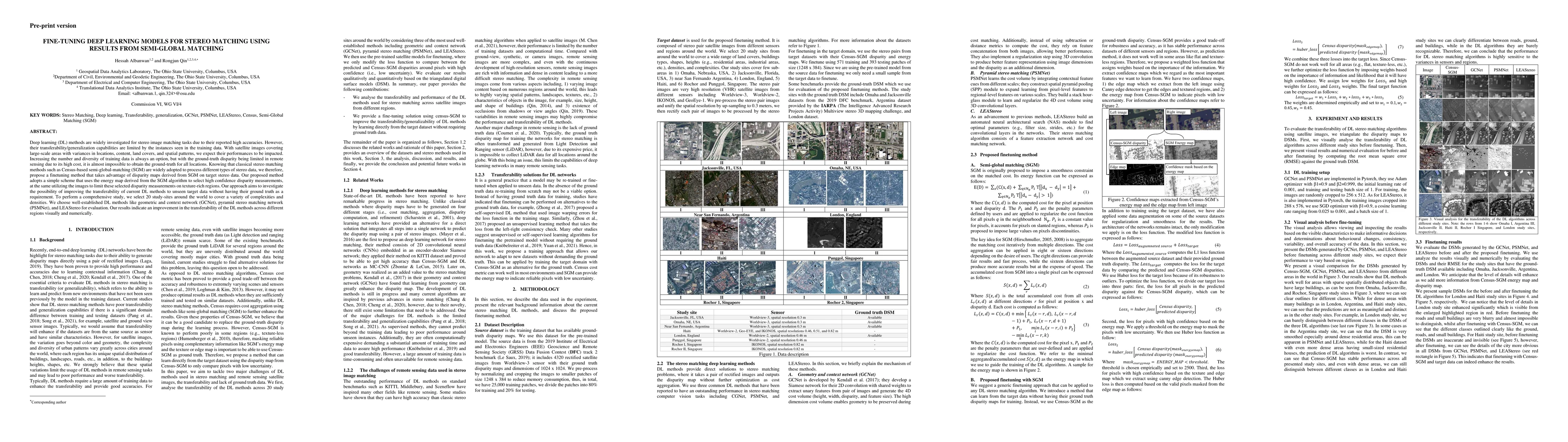
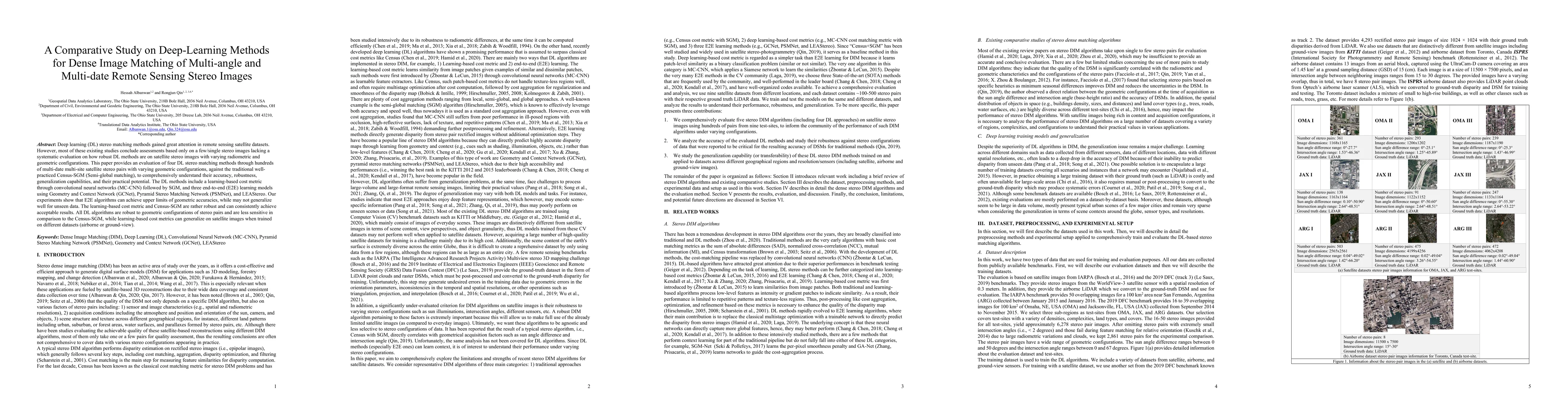
Deep learning (DL) methods are widely investigated for stereo image matching tasks due to their reported high accuracies. However, their transferability/generalization capabilities are limited by th...
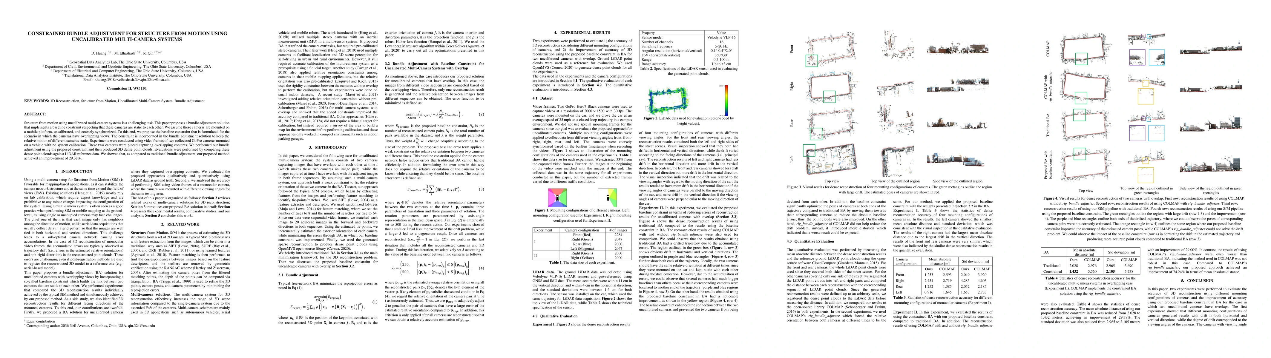
Structure from motion using uncalibrated multi-camera systems is a challenging task. This paper proposes a bundle adjustment solution that implements a baseline constraint respecting that these came...
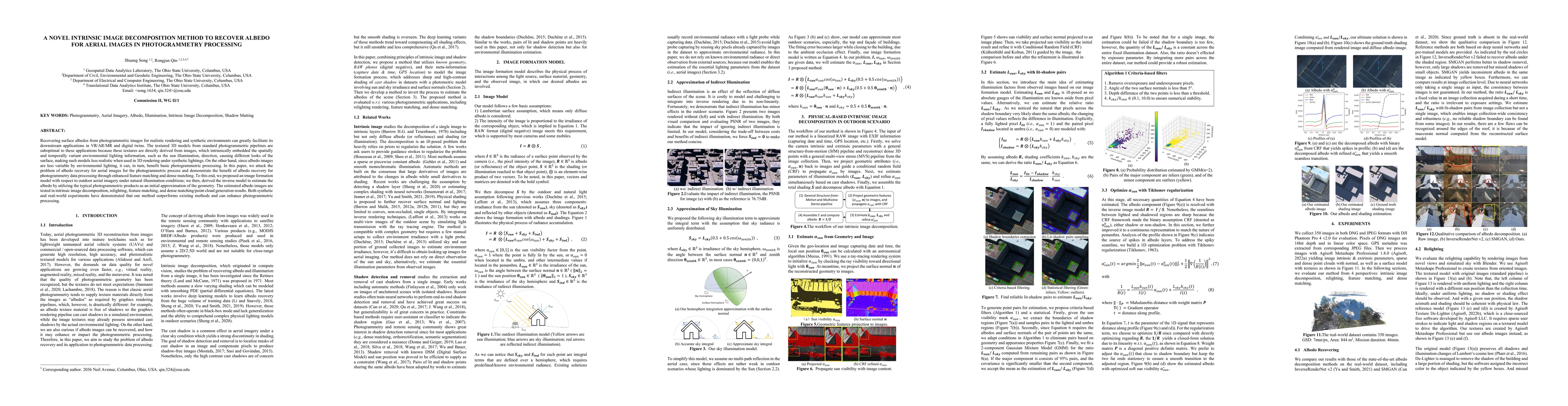
Recovering surface albedos from photogrammetric images for realistic rendering and synthetic environments can greatly facilitate its downstream applications in VR/AR/MR and digital twins. The textur...
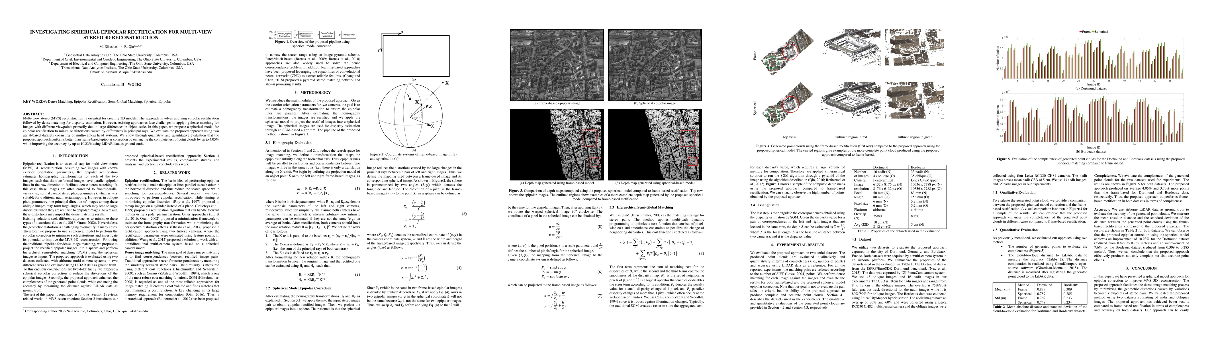
Multi-view stereo (MVS) reconstruction is essential for creating 3D models. The approach involves applying epipolar rectification followed by dense matching for disparity estimation. However, existi...
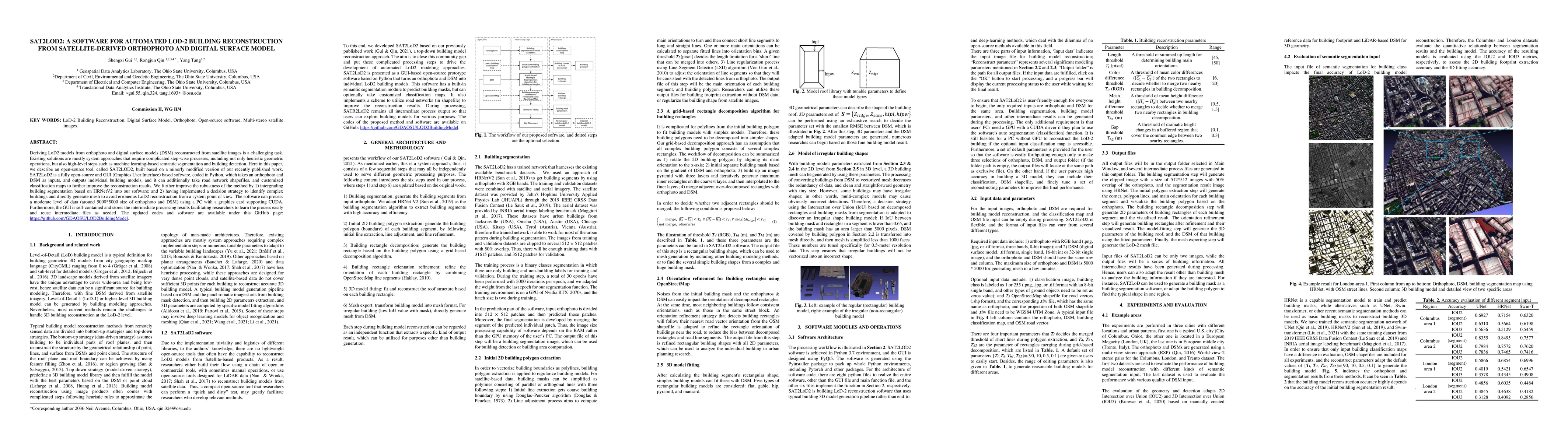
Deriving LoD2 models from orthophoto and digital surface models (DSM) reconstructed from satellite images is a challenging task. Existing solutions are mostly system approaches that require complica...
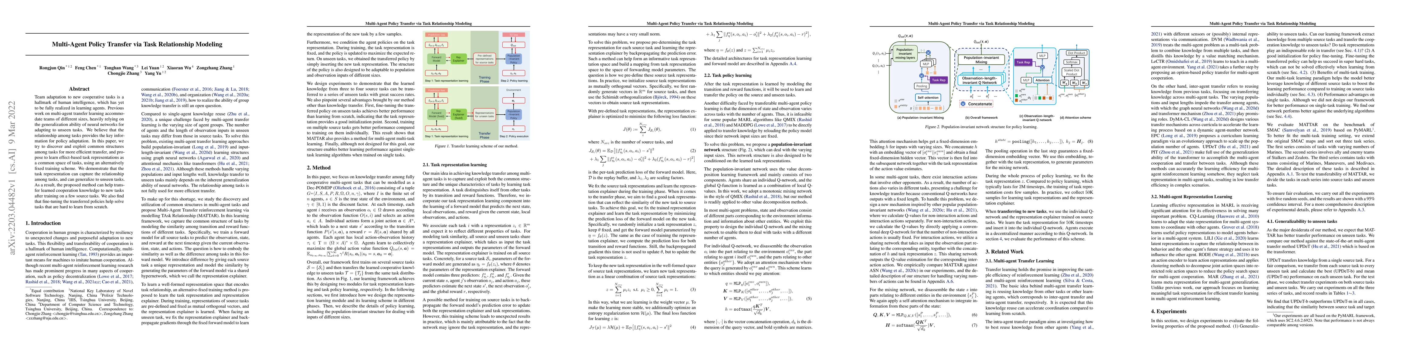
Team adaptation to new cooperative tasks is a hallmark of human intelligence, which has yet to be fully realized in learning agents. Previous work on multi-agent transfer learning accommodate teams ...
In this paper, based on the assumption that the object boundaries (e.g., buildings) from the over-view data should coincide with footprints of fa\c{c}ade 3D points generated from street-view photogr...
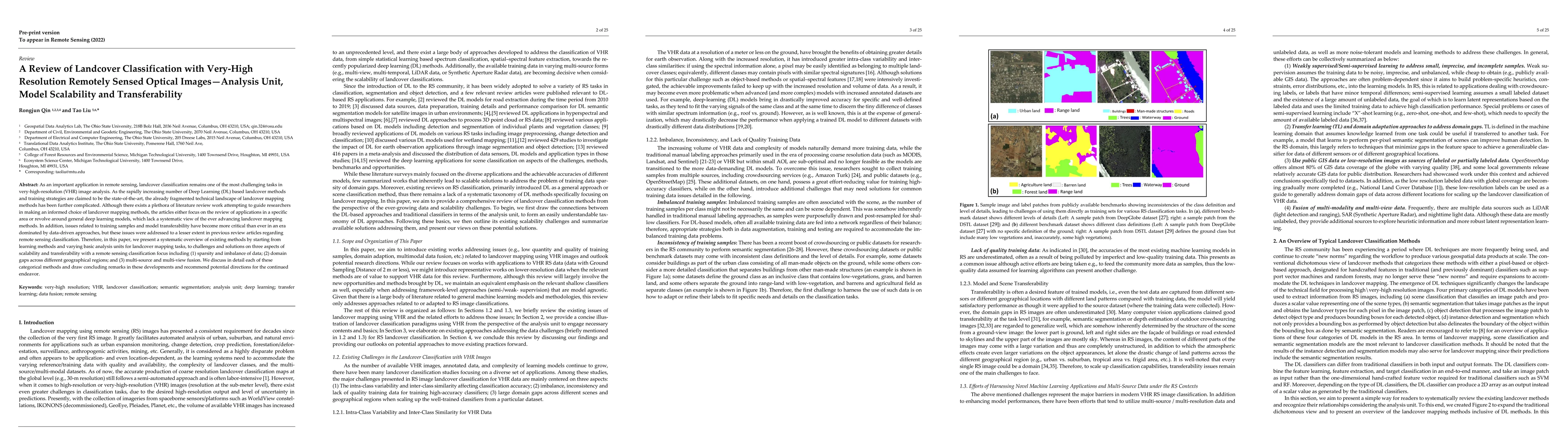
As an important application in remote sensing, landcover classification remains one of the most challenging tasks in very-high-resolution (VHR) image analysis. As the rapidly increasing number of De...
In this paper, we propose a model-driven method that reconstructs LoD-2 building models following a "decomposition-optimization-fitting" paradigm. The proposed method starts building detection resul...
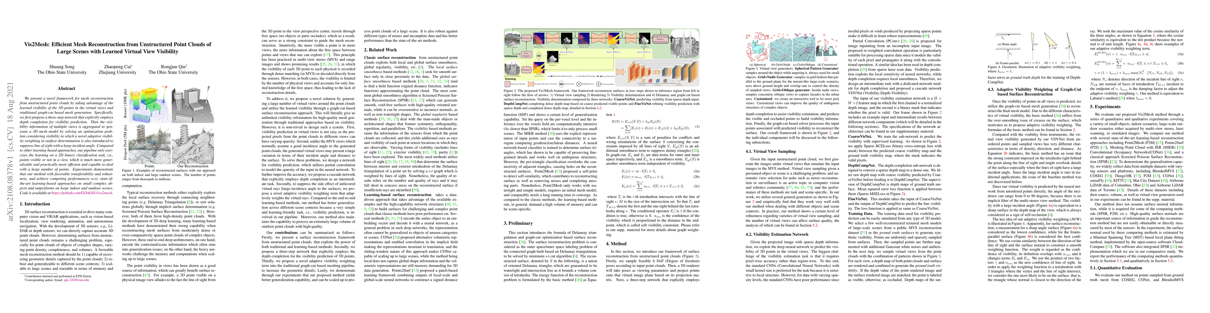
We present a novel framework for mesh reconstruction from unstructured point clouds by taking advantage of the learned visibility of the 3D points in the virtual views and traditional graph-cut base...
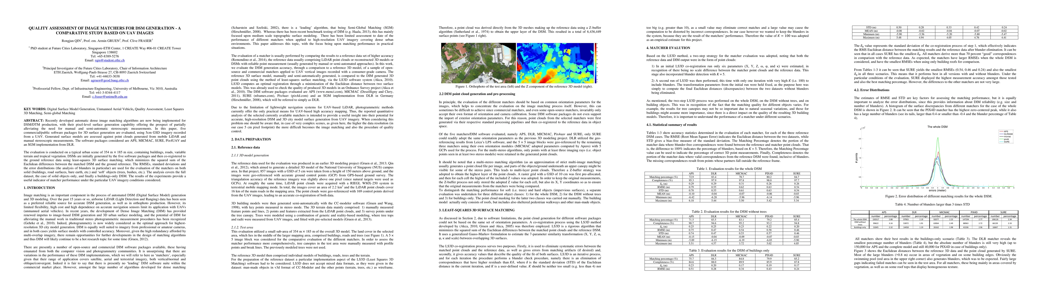
Recently developed automatic dense image matching algorithms are now being implemented for DSM/DTM production, with their pixel-level surface generation capability offering the prospect of partially...
In this paper, we present a case study that performs an unmanned aerial vehicle (UAV) based fine-scale 3D change detection and monitoring of progressive collapse performance of a building during a d...
Remote sensing images and techniques are powerful tools to investigate earth surface. Data quality is the key to enhance remote sensing applications and obtaining a clear and noise-free set of data ...
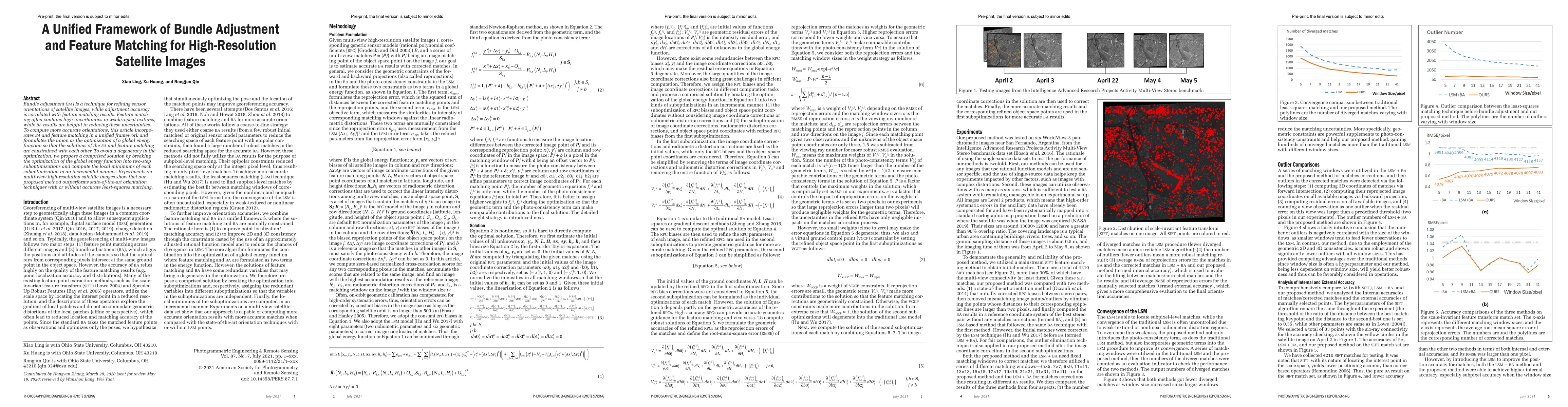
Bundle adjustment (BA) is a technique for refining sensor orientations of satellite images, while adjustment accuracy is correlated with feature matching results. Feature match-ing often contains hi...
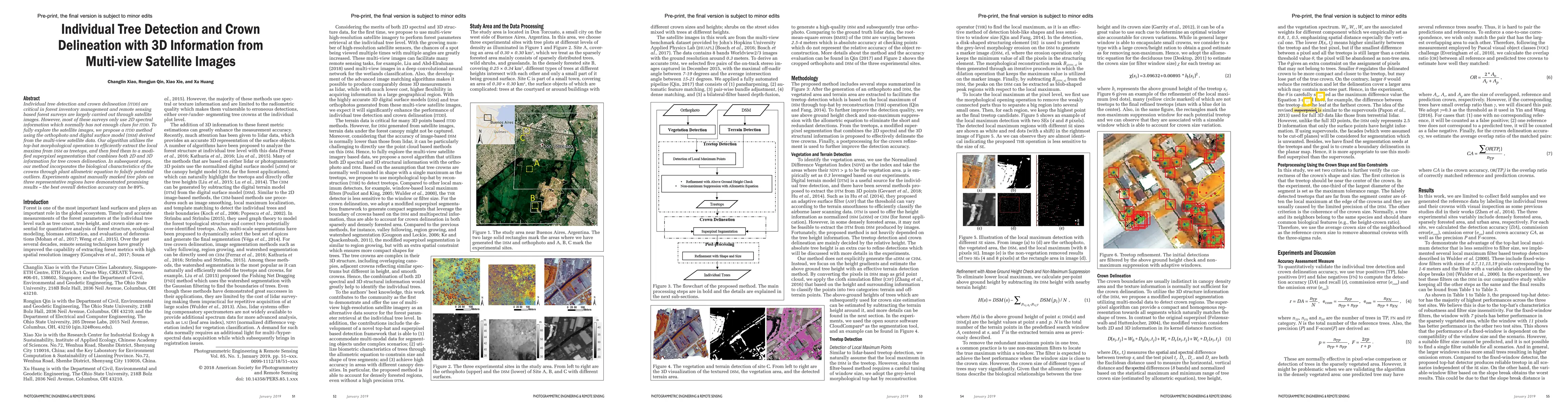
Individual tree detection and crown delineation (ITDD) are critical in forest inventory management and remote sensing based forest surveys are largely carried out through satellite images. However, ...
The current practice in land cover/land use change analysis relies heavily on the individually classified maps of the multitemporal data set. Due to varying acquisition conditions (e.g., illuminatio...
The geodatabase (vectorized data) nowadays becomes a rather standard digital city infrastructure; however, updating geodatabase efficiently and economically remains a fundamental and practical issue...
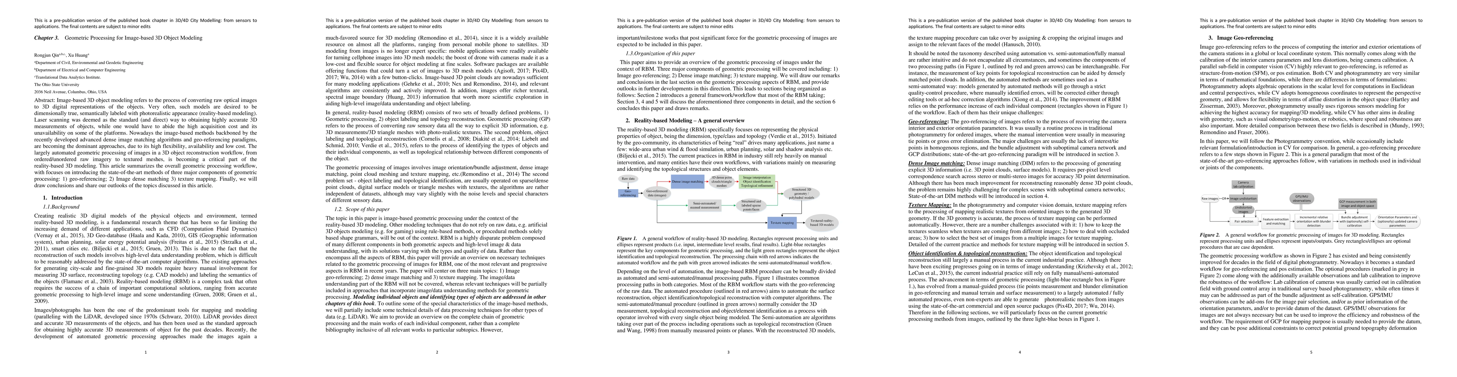
Image-based 3D object modeling refers to the process of converting raw optical images to 3D digital representations of the objects. Very often, such models are desired to be dimensionally true, sema...
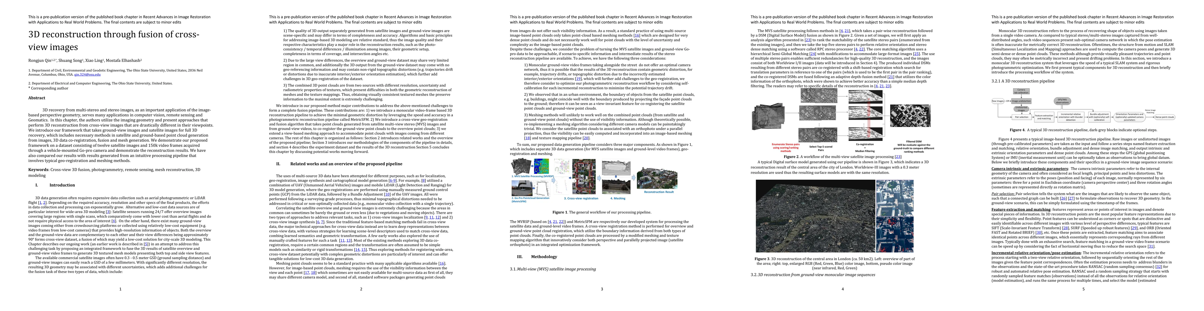
3D recovery from multi-stereo and stereo images, as an important application of the image-based perspective geometry, serves many applications in computer vision, remote sensing and Geomatics. In th...
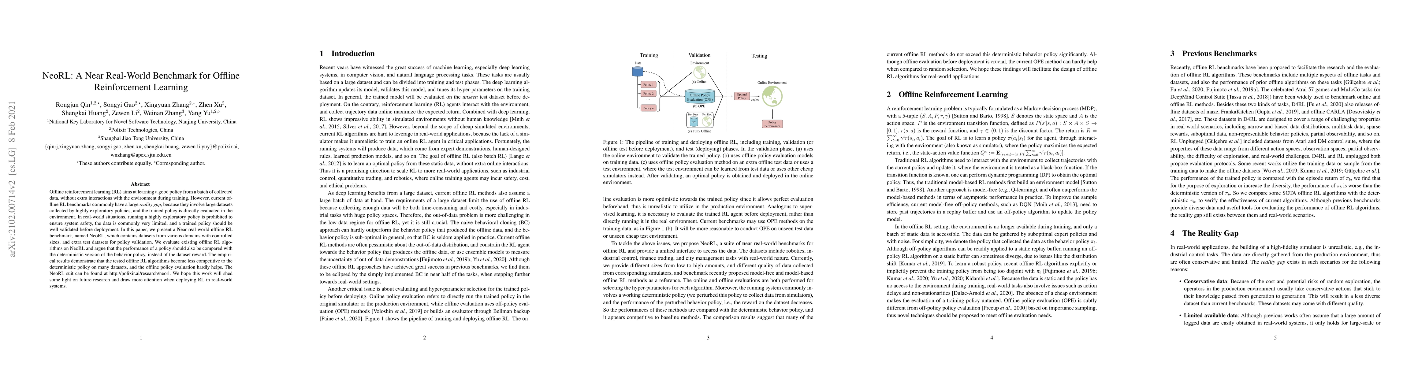
Offline reinforcement learning (RL) aims at learning a good policy from a batch of collected data, without extra interactions with the environment during training. However, current offline RL benchm...
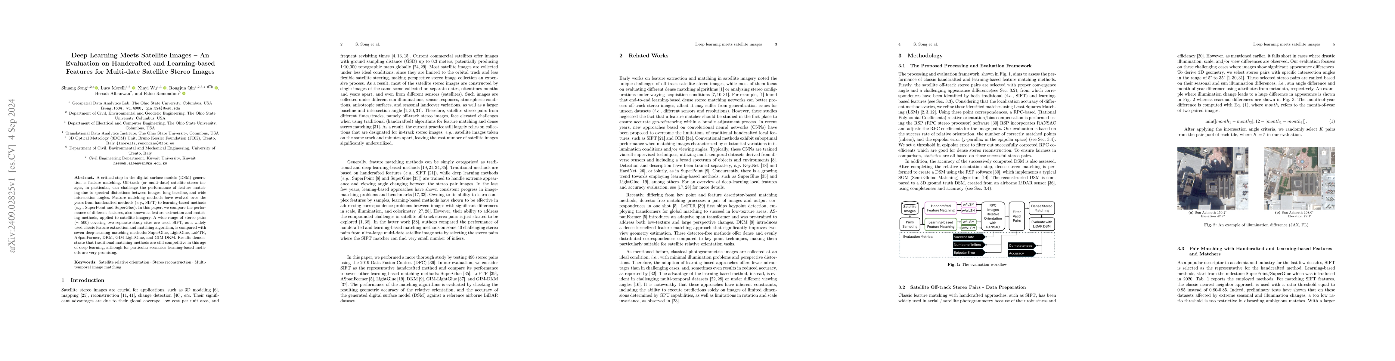
A critical step in the digital surface models(DSM) generation is feature matching. Off-track (or multi-date) satellite stereo images, in particular, can challenge the performance of feature matching d...
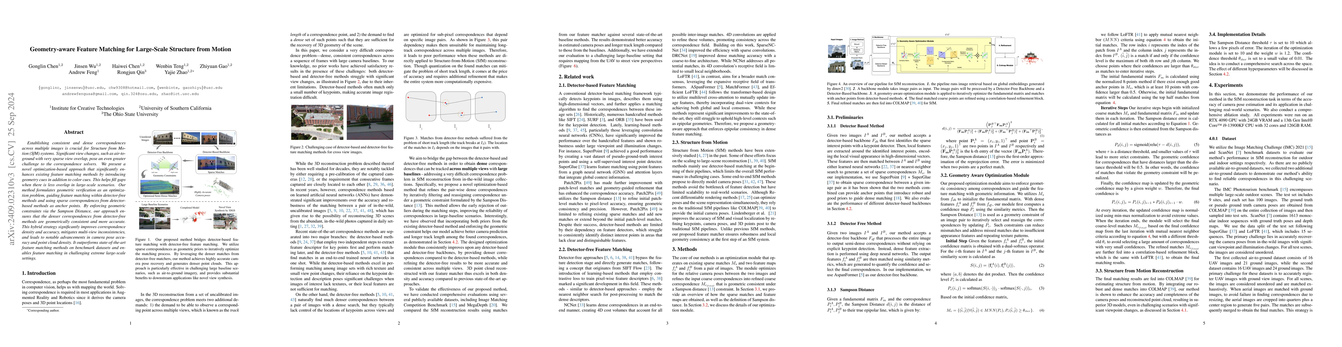
Establishing consistent and dense correspondences across multiple images is crucial for Structure from Motion (SfM) systems. Significant view changes, such as air-to-ground with very sparse view overl...
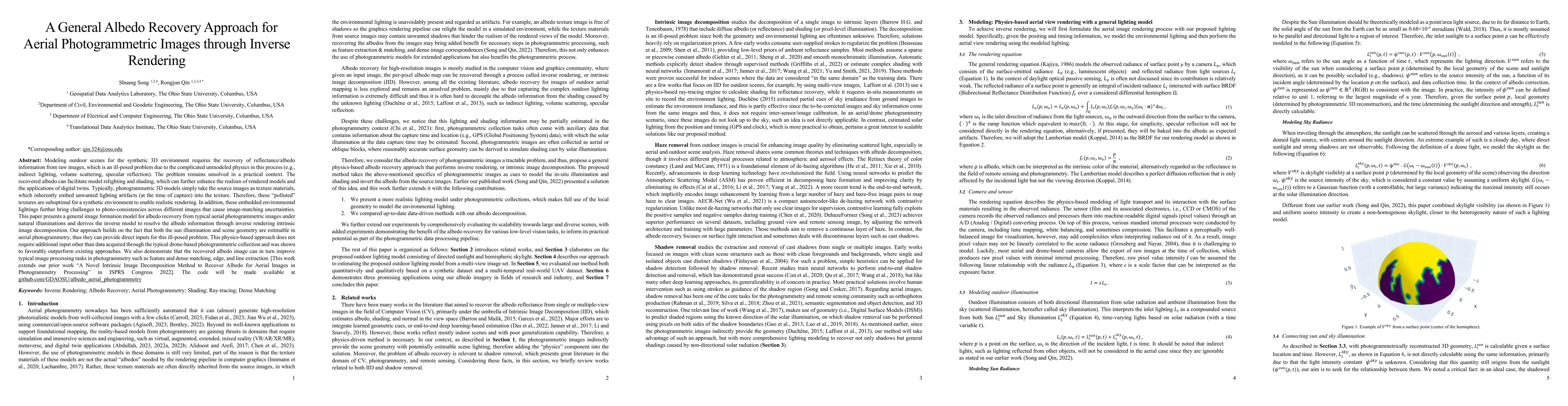
Modeling outdoor scenes for the synthetic 3D environment requires the recovery of reflectance/albedo information from raw images, which is an ill-posed problem due to the complicated unmodeled physics...
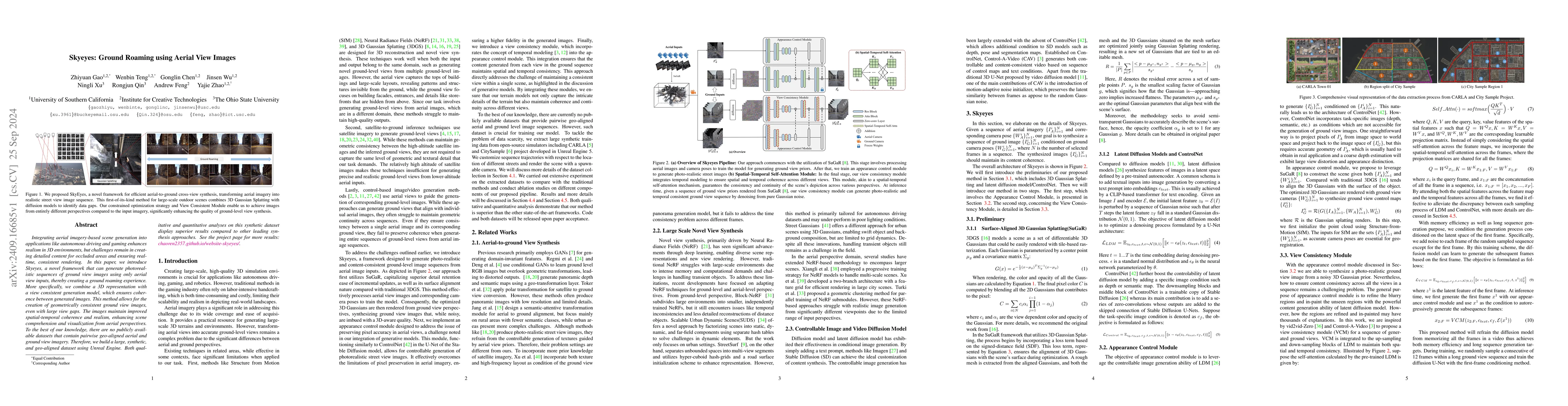
Integrating aerial imagery-based scene generation into applications like autonomous driving and gaming enhances realism in 3D environments, but challenges remain in creating detailed content for occlu...
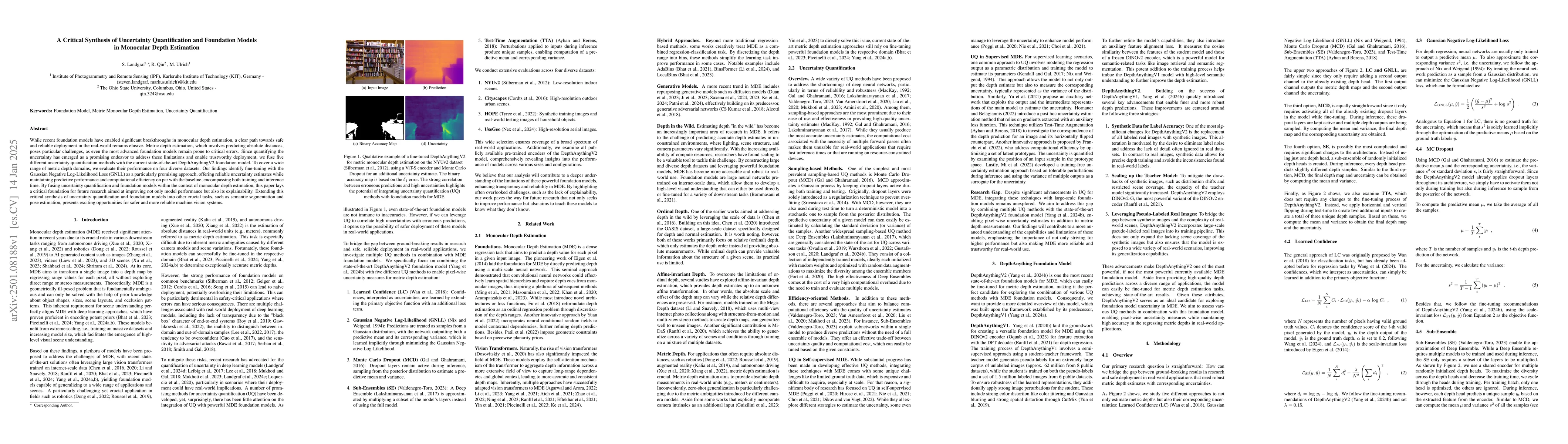
While recent foundation models have enabled significant breakthroughs in monocular depth estimation, a clear path towards safe and reliable deployment in the real-world remains elusive. Metric depth e...
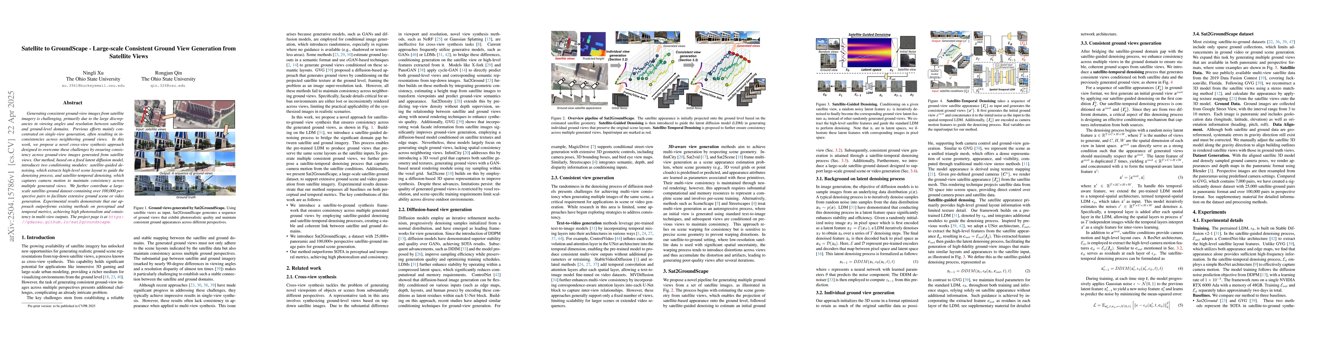
Generating consistent ground-view images from satellite imagery is challenging, primarily due to the large discrepancies in viewing angles and resolution between satellite and ground-level domains. Pr...
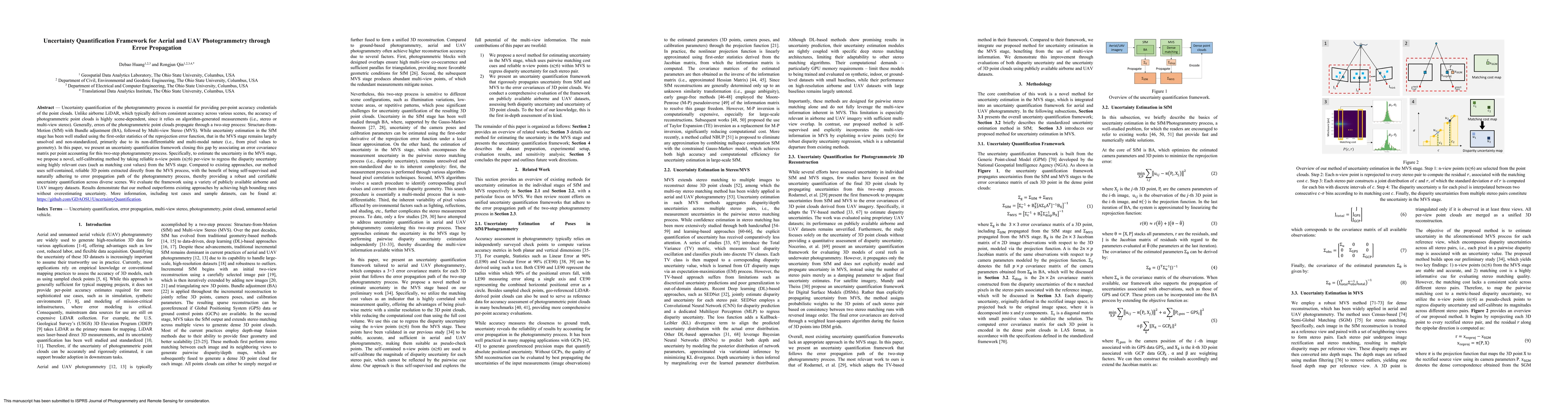
Uncertainty quantification of the photogrammetry process is essential for providing per-point accuracy credentials of the point clouds. Unlike airborne LiDAR, which typically delivers consistent accur...
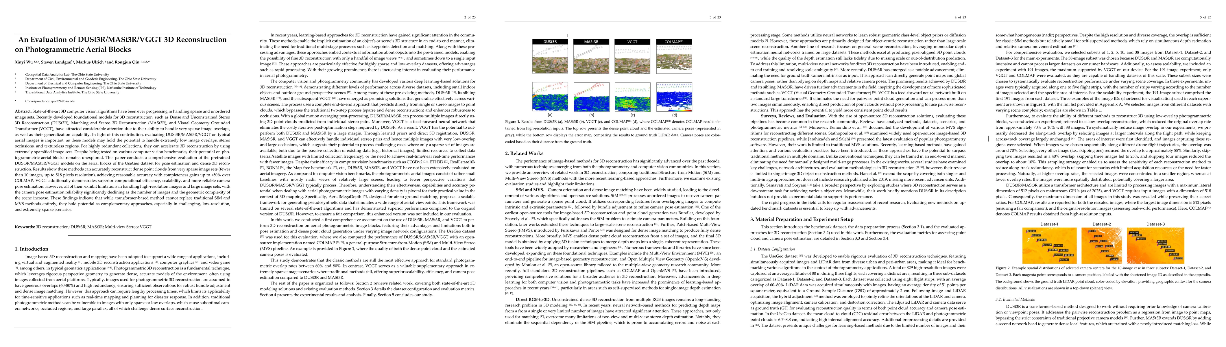
State-of-the-art 3D computer vision algorithms continue to advance in handling sparse, unordered image sets. Recently developed foundational models for 3D reconstruction, such as Dense and Unconstrain...
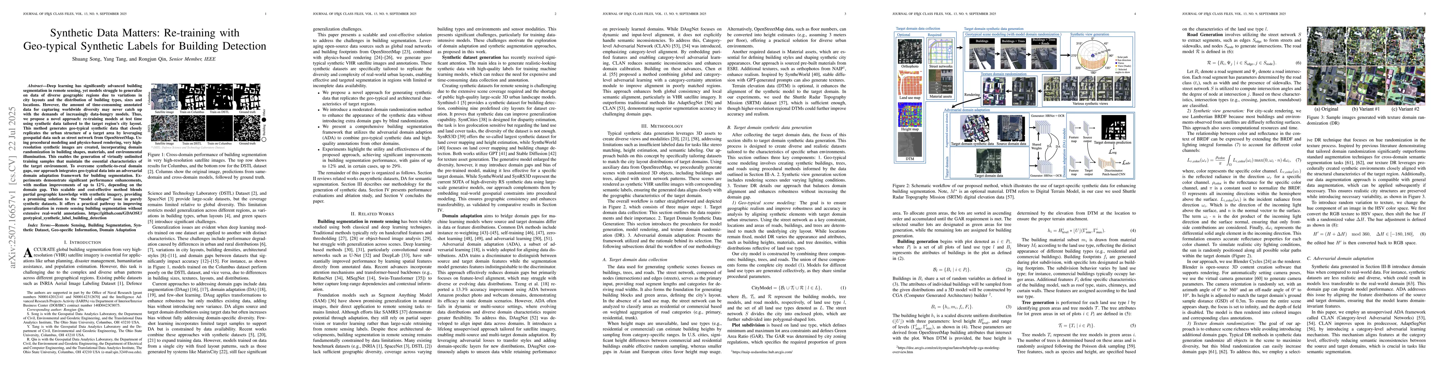
Deep learning has significantly advanced building segmentation in remote sensing, yet models struggle to generalize on data of diverse geographic regions due to variations in city layouts and the dist...
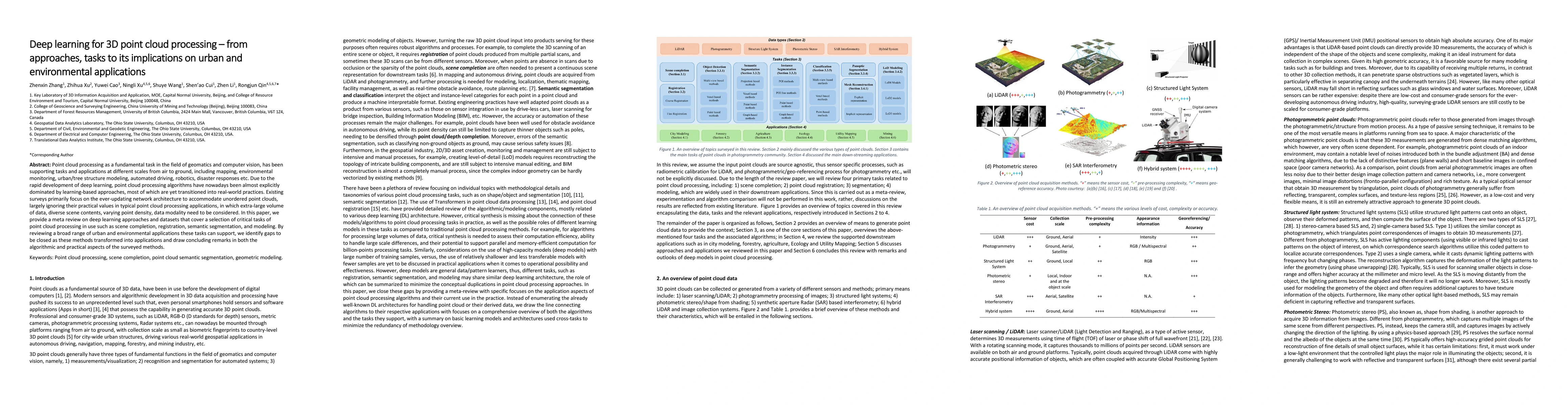
Point cloud processing as a fundamental task in the field of geomatics and computer vision, has been supporting tasks and applications at different scales from air to ground, including mapping, enviro...
Intrinsic image decomposition (IID) of outdoor scenes is crucial for relighting, editing, and understanding large-scale environments, but progress has been limited by the lack of real-world datasets w...
Recent advances in 4D scene reconstruction have significantly improved dynamic modeling across various domains. However, existing approaches remain limited under aerial conditions with single-view cap...
3D Gaussian Splatting (3DGS) has revolutionized real-time rendering with its state-of-the-art novel view synthesis, but its utility for accurate geometric measurement remains underutilized. Compared t...
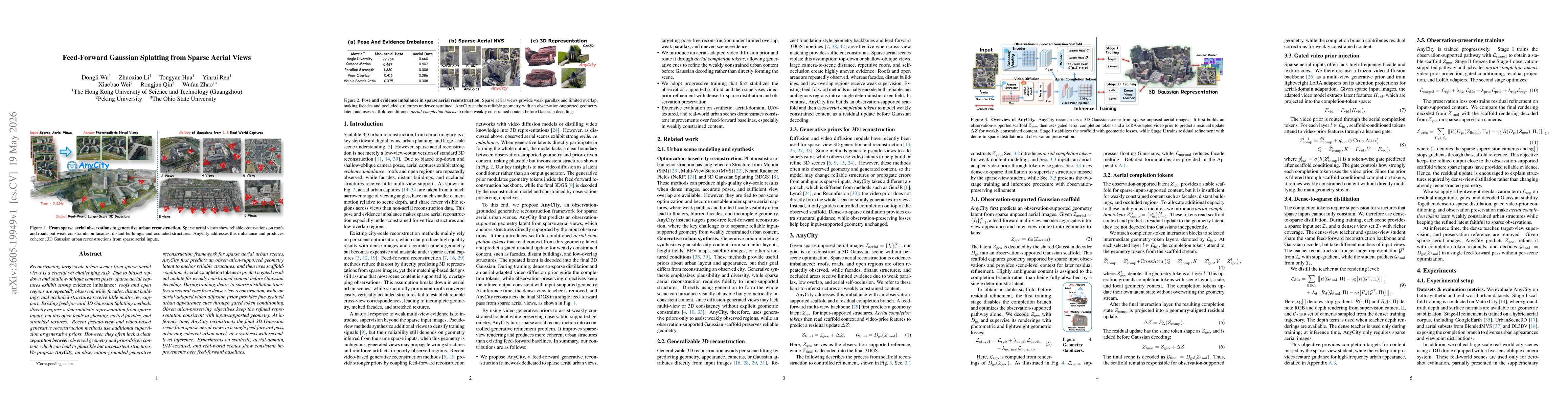
Reconstructing large-scale urban scenes from sparse aerial views is a crucial yet challenging task. Due to biased top-down and shallow-oblique camera poses, sparse aerial captures exhibit strong evide...
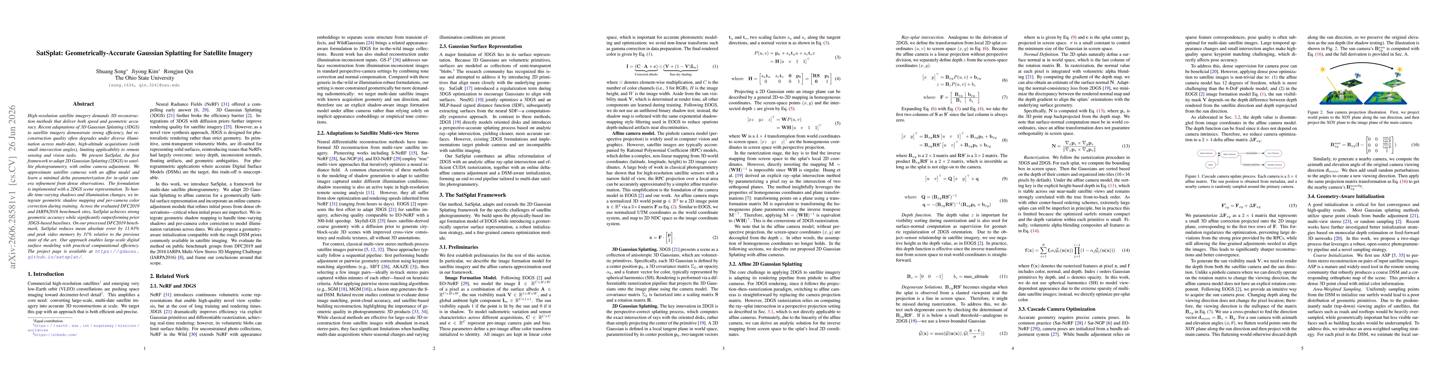
High-resolution satellite imagery demands 3D reconstruction methods that deliver both speed and geometric accuracy. Recent adaptations of 3D Gaussian Splatting (3DGS) to satellite imagery demonstrate ...