This paper provides a comprehensive overview and meta-analysis of image fusion in remote sensing, categorizing it into many-to-one and many-to-many fusion types. It reviews 5,926 papers to highlight major advancements and challenges, offering future research directions.
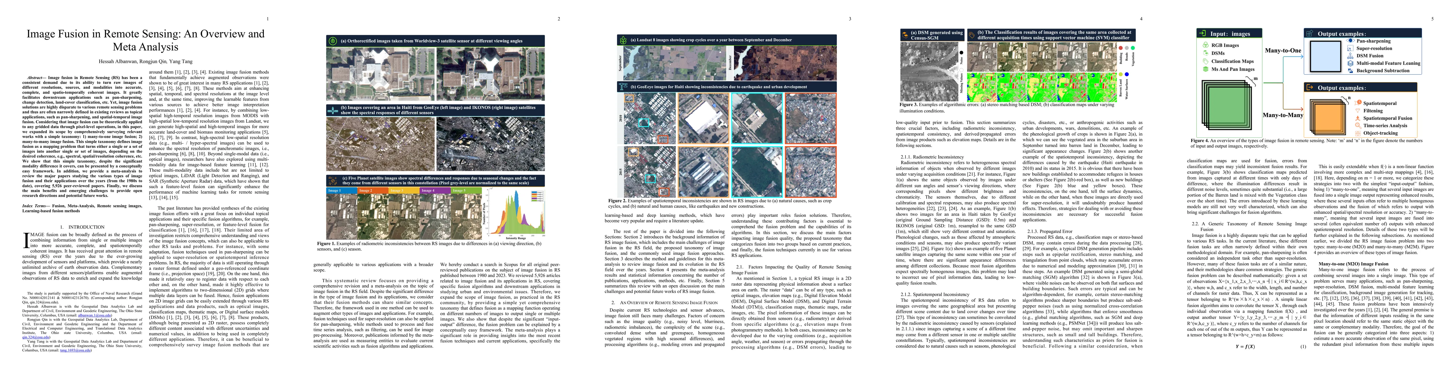
Image fusion in Remote Sensing (RS) has been a consistent demand due to its ability to turn raw images of different resolutions, sources, and modalities into accurate, complete, and spatio-temporally coherent images. It greatly facilitates downstream applications such as pan-sharpening, change detection, land-cover classification, etc. Yet, image fusion solutions are highly disparate to various remote sensing problems and thus are often narrowly defined in existing reviews as topical applications, such as pan-sharpening, and spatial-temporal image fusion. Considering that image fusion can be theoretically applied to any gridded data through pixel-level operations, in this paper, we expanded its scope by comprehensively surveying relevant works with a simple taxonomy: 1) many-to-one image fusion; 2) many-to-many image fusion. This simple taxonomy defines image fusion as a mapping problem that turns either a single or a set of images into another single or set of images, depending on the desired coherence, e.g., spectral, spatial/resolution coherence, etc. We show that this simple taxonomy, despite the significant modality difference it covers, can be presented by a conceptually easy framework. In addition, we provide a meta-analysis to review the major papers studying the various types of image fusion and their applications over the years (from the 1980s to date), covering 5,926 peer-reviewed papers. Finally, we discuss the main benefits and emerging challenges to provide open research directions and potential future works.
Get AI-generated insights about this paper's methodology, results, and significance.
Current paper (gray), citations (green), references (blue)
Title | Authors | Year | Actions |
---|---|---|---|
Distilling Textual Priors from LLM to Efficient Image Fusion
|
Ran Zhang, Xuanhua He, Ke Cao, Liu Liu, Li Zhang, Man Zhou, Jie Zhang
|
2025
|
View Paper |
Task-driven Image Fusion with Learnable Fusion Loss
|
Haowen Bai, Jiangshe Zhang, Zixiang Zhao, Yichen Wu, Lilun Deng, Yukun Cui, Tao Feng, Shuang Xu
|
2024
|
View Paper |
Title | Authors | Year | Actions |
---|---|---|---|
A survey of machine learning and deep learning in remote sensing of geological environment: Challenges, advances, and opportunities
|
Wei Han, Xiaohan Zhang, Yi Wang, Lizhe Wang, Xiaohui Huang, Jun Li, Shengte Wang, Weitao Chen, Xianju Li, Ruyi Feng, R. Fan, Xinyu Zhang, Yuewei Wang
|
2023
|
View Paper |
Adaptive Speckle Filter for Multi-Temporal PolSAR Image with Multi-Dimensional Information Fusion
|
Hao-Liang Li, X. Cui, Ming-Dian Li, Junwu Deng, Siwei Chen
|
2023
|
View Paper |
Graph Neural Network-Based Method of Spatiotemporal Land Cover Mapping Using Satellite Imagery
|
Domen Kavran, Domen Mongus, B. Žalik, N. Lukač
|
2023
|
View Paper |
Panchromatic and multispectral image fusion for remote sensing and earth observation: Concepts, taxonomy, literature review, evaluation methodologies and challenges ahead
|
Kai Zhang, Feng Zhang, Wenbo Wan, Hui Yu, Jiande Sun, Javier Del Ser, Eyad Elyan, Amir Hussain
|
2023
|
View Paper |
Thick Cloud Removal in Multi-Temporal Remote Sensing Images via Frequency Spectrum-Modulated Tensor Completion
|
Zhihong Chen, P. Zhang, Yu Zhang, Xunpeng Xu, Luyan Ji, Hairong Tang
|
2023
|
View Paper |
Prediction of Radar Echo Space-Time Sequence Based on Improving TrajGRU Deep-Learning Model
|
Qiangyu Zeng, Haoran Li, Tao Zhang, Jianxin He, Fugui Zhang, Hao Wang, Zhipeng Qing, Qiu Yu, Bangyue Shen
|
2022
|
View Paper |
Reconstruction of Sentinel-2 Image Time Series Using Google Earth Engine
|
Kaixiang Yang, You-Zhen Luo, Mengyao Li, Shouyi Zhong, Qiang Liu, Xiuhong Li
|
2022
|
View Paper |
Transformers in Remote Sensing: A Survey
|
Abdulaziz Amer Aleissaee, Amandeep Kumar, R. Anwer, Salman H. Khan, Hisham Cholakkal, Guisong Xia, F. Khan
|
2022
|
View Paper |
Review of pixel-level remote sensing image fusion based on deep learning
|
Zhaobin Wang, Yikun Ma, Yaonan Zhang
|
2022
|
View Paper |
Retrieval of high spatial resolution precipitable water vapor maps using heterogeneous earth observation data
|
Xiongwei Ma, Yibin Yao, Bao Zhang, Changyong He
|
2022
|
View Paper |
Deep Pansharpening via 3D Spectral Super-Resolution Network and Discrepancy-Based Gradient Transfer
|
Haonan Su, Haiyan Jin, Ce Sun
|
2022
|
View Paper |
Mapping an alien invasive shrub within conservation corridors using super-resolution satellite imagery.
|
K. J. Theron, J. Pryke, Nicolas Latte, M. Samways
|
2022
|
View Paper |
Object Tracking Based on Satellite Videos: A Literature Review
|
Zhaoxiang Zhang, Chenghang Wang, Jianing Song, Yuelei Xu
|
2022
|
View Paper |
Water Body Extraction in Remote Sensing Imagery Using Domain Adaptation-Based Network Embedding Selective Self-Attention and Multi-Scale Feature Fusion
|
Jiahang Liu, Yue Wang
|
2022
|
View Paper |
Image Fusion Based on Discrete Cosine Transform with High Compression
|
Emadalden Alhatami, U. Bhatti, Mengxing Huang, Siling Feng
|
2022
|
View Paper |
Swin-Transformer-Enabled YOLOv5 with Attention Mechanism for Small Object Detection on Satellite Images
|
Hang Gong, Tingkui Mu, Qiuxia Li, H. Dai, Chunlai Li, Zhiping He, Wenjing Wang, Feng Han, Abudusalamu Tuniyazi, Haoyang Li, Xuechan Lang, Zhiyuan Li, Bin Wang
|
2022
|
View Paper |
Self-supervised Vision Transformers for Land-cover Segmentation and Classification
|
L. Scheibenreif, Joelle Hanna, Michael Mommert, Damian Borth
|
2022
|
View Paper |
Uncertainty-Guided Depth Fusion from Multi-View Satellite Images to Improve the Accuracy in Large-Scale DSM Generation
|
R. Qin, Xiao Ling, Elisabetta Farella, F. Remondino
|
2022
|
View Paper |
Transformer with Transfer CNN for Remote-Sensing-Image Object Detection
|
Qingyun Li, Yushi Chen, Ying Zeng
|
2022
|
View Paper |
Flood Discharge Prediction Based on Remote-Sensed Spatiotemporal Features Fusion and Graph Attention
|
Chen Chen, Dingbin Luan, Song Zhao, Zhan Liao, Yang Zhou, Jiange Jiang, Qingqi Pei
|
2021
|
View Paper |
A Robust Hybrid Deep Learning Model for Spatiotemporal Image Fusion
|
Zijun Yang, C. Diao, Bo Li
|
2021
|
View Paper |
Generating gapless land surface temperature with a high spatio-temporal resolution by fusing multi-source satellite-observed and model-simulated data
|
Jun Ma, Huanfeng Shen, Penghai Wu, Jingan Wu, Meiling Gao, C. Meng
|
2021
|
View Paper |
Research on Building DSM Fusion Method Based on Adaptive Spline and Target Characteristic Guidance
|
Jinming Liu, Hao Chen, Shuting Yang
|
2021
|
View Paper |
Building Extraction from Remote Sensing Images with Sparse Token Transformers
|
Keyan Chen, Zhengxia Zou, Zhenwei Shi
|
2021
|
View Paper |
Comparison of Remote Sensing Image Fusion Rules Based on the Laplacian Pyramid Transformation
|
Ruixue Su, Li Sun, Jinling Wang
|
2021
|
View Paper |
MSNet: A Multi-Stream Fusion Network for Remote Sensing Spatiotemporal Fusion Based on Transformer and Convolution
|
Weisheng Li, Dongwen Cao, Yidong Peng, Chao Yang
|
2021
|
View Paper |
Robust deep alignment network with remote sensing knowledge graph for zero-shot and generalized zero-shot remote sensing image scene classification
|
Yansheng Li, Deyu Kong, Yongjun Zhang, Yihua Tan, Ling Chen
|
2021
|
View Paper |
MSResNet: Multiscale Residual Network via Self-Supervised Learning for Water-Body Detection in Remote Sensing Imagery
|
Bo Dang, Yansheng Li
|
2021
|
View Paper |
Deep Learning: A Comprehensive Overview on Techniques, Taxonomy, Applications and Research Directions
|
Iqbal H. Sarker
|
2021
|
View Paper |
Remote Sensing Image Spatiotemporal Fusion Using a Generative Adversarial Network
|
Hongyan Zhang, Yiyao Song, Chang Han, L. Zhang
|
2021
|
View Paper |
Multisensor and Multiresolution Remote Sensing Image Classification through a Causal Hierarchical Markov Framework and Decision Tree Ensembles
|
Martina Pastorino, Alessandro Montaldo, L. Fronda, Ihsen Hedhli, G. Moser, S. Serpico, J. Zerubia
|
2021
|
View Paper |
Vision Transformers for Remote Sensing Image Classification
|
Y. Bazi, Laila Bashmal, Mohamad Mahmoud Al Rahhal, Reham Al Dayil, N. A. Ajlan
|
2021
|
View Paper |
Spatiotemporal analysis of land surface temperature using multi-temporal and multi-sensor image fusion techniques
|
K. Ezimand, Manouchehr Chahardoli, M. Azadbakht, A. Matkan
|
2021
|
View Paper |
Fourier Domain Anomaly Detection and Spectral Fusion for Stripe Noise Removal of TIR Imagery
|
Qingjie Zeng, Hanlin Qin, Xiang Yan, Tingwu Yang
|
2020
|
View Paper |
A Comparison of UAV and Satellites Multispectral Imagery in Monitoring Onion Crop. An Application in the 'Cipolla Rossa di Tropea' (Italy)
|
G. Messina, J. Peña, Marco Vizzari, G. Modica
|
2020
|
View Paper |
Stereo Dense Image Matching by Adaptive Fusion of Multiple-Window Matching Results
|
Yilong Han, Wei Liu, Xu Huang, Shugen Wang, R. Qin
|
2020
|
View Paper |
Detection of Canopy Chlorophyll Content of Corn Based on Continuous Wavelet Transform Analysis
|
Junyi Zhang, Hong Sun, Dehua Gao, Lang Qiao, Ning Liu, Minzan Li, Yao Zhang
|
2020
|
View Paper |
Stereo matching algorithm based on deep learning: A survey
|
M. Hamid, N. A. Manap, R. A. Hamzah, A. F. Kadmin
|
2020
|
View Paper |
Vehicle Detection of Multi-source Remote Sensing Data Using Active Fine-tuning Network
|
Xin Wu, Wei Li, D. Hong, Jiaojiao Tian, R. Tao, Q. Du
|
2020
|
View Paper |
Combining Kriging Interpolation to Improve the Accuracy of Forest Aboveground Biomass Estimation Using Remote Sensing Data
|
Yingchang Li, Mingyang Li, Zhenzhen Liu, Chao-kui Li
|
2020
|
View Paper |
Multi-image Super Resolution of Remotely Sensed Images using Residual Feature Attention Deep Neural Networks
|
Francesco Salvetti, Vittorio Mazzia, Aleem Khaliq, M. Chiaberge
|
2020
|
View Paper |
A pixel-level fusion method for multi-source optical remote sensing image combining the principal component analysis and curvelet transform
|
Chao Chen, Xinyue He, Biyun Guo, Xin Zhao, Yanli Chu
|
2020
|
View Paper |
Land Use/Land Cover Mapping Using Multitemporal Sentinel-2 Imagery and Four Classification Methods - A Case Study from Dak Nong, Vietnam
|
H. Nguyen, T. M. Doan, E. Tomppo, R. McRoberts
|
2020
|
View Paper |
CNN based spectral super-resolution of remote sensing images
|
P. V. Arun, K. Buddhiraju, A. Porwal, J. Chanussot
|
2020
|
View Paper |
Review of Stereo Matching Algorithms Based on Deep Learning
|
Kun Zhou, Xiangxi Meng, Bo Cheng
|
2020
|
View Paper |
A PCA-PD fusion method for change detection in remote sensing multi temporal images
|
Soltana Achour, Miloud Chikr Elmezouar, N. Taleb, K. Kpalma, J. Ronsin
|
2020
|
View Paper |
ResDepth: Learned Residual Stereo Reconstruction
|
Corinne Stucker, K. Schindler
|
2020
|
View Paper |
Learning discriminative spatiotemporal features for precise crop classification from multi-temporal satellite images
|
Shunping Ji, Zhili Zhang, Chi Zhang, Shiqing Wei, Meng Lu, Y. Duan
|
2019
|
View Paper |
Bidirectional Convolutional LSTM Neural Network for Remote Sensing Image Super-Resolution
|
Yunpeng Chang, Bin Luo
|
2019
|
View Paper |
Unsupervised Image Regression for Heterogeneous Change Detection
|
L. Luppino, F. Bianchi, G. Moser, S. N. Anfinsen
|
2019
|
View Paper |
A critical analysis of satellite stereo pairs for digital surface model generation and a matching quality prediction model
|
R. Qin
|
2019
|
View Paper |
Remote sensing data quality model: from data sources to lifecycle phases
|
Á. Barsi, Z. Kugler, A. Juhász, G. Szabó, C. Batini, H. Abdulmuttalib, Guoman Huang, Huanfeng Shen
|
2019
|
View Paper |
Spatial frequency discrete wavelet transform image fusion technique for remote sensing applications
|
Joy Jinju, N. Santhi, K. Ramar, B. Bama
|
2019
|
View Paper |
Land Cover Classification from fused DSM and UAV Images Using Convolutional Neural Networks
|
H. Al-Najjar, B. Kalantar, B. Pradhan, V. Saeidi, Alfian Abdul Halin, N. Ueda, S. Mansor
|
2019
|
View Paper |
A probabilistic fusion of a support vector machine and a joint sparsity model for hyperspectral imagery classification
|
Qishuo Gao, Samsung Lim
|
2019
|
View Paper |
An Efficient Approach to Remove Thick Cloud in VNIR Bands of Multi-Temporal Remote Sensing Images
|
Wenhui Du, Zhihao Qin, Jinlong Fan, Maofang Gao, Fei Wang, B. Abbasi
|
2019
|
View Paper |
Automated 3D recovery from very high resolution multi-view satellite images
|
R. Qin
|
2019
|
View Paper |
Long-Term Satellite Image Time-Series for Land Use/Land Cover Change Detection Using Refined Open Source Data in a Rural Region
|
Cláudia M. Viana, Inês Girão, J. Rocha
|
2019
|
View Paper |
Robust Band-Dependent Spatial-Detail Approaches for Panchromatic Sharpening
|
G. Vivone
|
2019
|
View Paper |
Spatiotemporal Image Fusion in Remote Sensing
|
Mariana Belgiu, A. Stein
|
2019
|
View Paper |
Change detection techniques for remote sensing applications: a survey
|
A. Asokan, J. Anitha
|
2019
|
View Paper |
Remote Sensing Image Fusion Based on Sparse Representation and Guided Filtering
|
Xiaole Ma, Shaohai Hu, Shuaiqi Liu, Jing Fang, Shuwen Xu
|
2019
|
View Paper |
Review of the pansharpening methods for remote sensing images based on the idea of meta-analysis: Practical discussion and challenges
|
Xiangchao Meng, Huanfeng Shen, Huifang Li, Liangpei Zhang, Randi Fu
|
2019
|
View Paper |
Evaluation of Different Machine Learning Methods and Deep-Learning Convolutional Neural Networks for Landslide Detection
|
O. Ghorbanzadeh, T. Blaschke, Khalil Gholamnia, S. Meena, D. Tiede, J. Aryal
|
2019
|
View Paper |
A Long Time-Series Radiometric Normalization Method for Landsat Images
|
Wei Wu, Xia Sun, Xianwei Wang, Jing Fan, Jiancheng Luo, Ying Shen, Yingpin Yang
|
2018
|
View Paper |
Fusion of SAR and Multispectral Images Using Random Forest Regression for Change Detection
|
D. Seo, Y. Kim, Y. Eo, Mi Hee Lee, Wan-Yong Park
|
2018
|
View Paper |
Pixel-wise regression using U-Net and its application on pansharpening
|
Wei Yao, Z. Zeng, Cheng Lian, Huiming Tang
|
2018
|
View Paper |
A Spectral-Temporal Patch-Based Missing Area Reconstruction for Time-Series Images
|
Wei Wu, Luoqi Ge, Jiancheng Luo, R. Huan, Yingpin Yang
|
2018
|
View Paper |
A novel spectrum enhancement technique for multi-temporal, multi-spectral data using spatial-temporal filtering
|
H. Albanwan, R. Qin
|
2018
|
View Paper |
Refining Land Cover Classification Maps Based on Dual-Adaptive Majority Voting Strategy for Very High Resolution Remote Sensing Images
|
Guoqing Cui, Z. Lv, Guangfei Li, J. Benediktsson, Yudong Lu
|
2018
|
View Paper |
Recurrent Multiresolution Convolutional Networks for VHR Image Classification
|
J. R. Bergado, C. Persello, A. Stein
|
2018
|
View Paper |
Spatiotemporal Fusion of Multisource Remote Sensing Data: Literature Survey, Taxonomy, Principles, Applications, and Future Directions
|
Xiaolin Zhu, Fangyi Cai, Jiaqi Tian, Trecia Kay-Ann Williams
|
2018
|
View Paper |
Full Scale Regression-Based Injection Coefficients for Panchromatic Sharpening
|
G. Vivone, R. Restaino, J. Chanussot
|
2018
|
View Paper |
Pyramid Stereo Matching Network
|
Jia-Ren Chang, Yonghao Chen
|
2018
|
View Paper |
A CNN-Based Fusion Method for Feature Extraction from Sentinel Data
|
G. Scarpa, M. Gargiulo, Antonio Mazza, R. Gaetano
|
2018
|
View Paper |
Implementation of machine-learning classification in remote sensing: an applied review
|
Aaron E. Maxwell, T. Warner, Fang Fang
|
2018
|
View Paper |
Spatio-Temporal Super-Resolution Reconstruction of Remote-Sensing Images Based on Adaptive Multi-Scale Detail Enhancement
|
Hong Zhu, Xinming Tang, Junfeng Xie, Weidong Song, F. Mo, Xiaoming Gao
|
2018
|
View Paper |
A Bayesian Data Fusion Approach to Spatio-Temporal Fusion of Remotely Sensed Images
|
Jie Xue, Y. Leung, T. Fung
|
2017
|
View Paper |
Construction of smooth daily remote sensing time series data: a higher spatiotemporal resolution perspective
|
Zhuokun Pan, Yueming Hu, Bin Cao
|
2017
|
View Paper |
Spatio-Temporal Series Remote Sensing Image Prediction Based on Multi-Dictionary Bayesian Fusion
|
Chu He, Zhi Zhang, Dehui Xiong, Juan Du, M. Liao
|
2017
|
View Paper |
Separate segmentation of multi-temporal high-resolution remote sensing images for object-based change detection in urban area
|
Xue-liang Zhang, P. Xiao, Xuezhi Feng, Minglei Yuan
|
2017
|
View Paper |
A Sparse Dictionary Learning-Based Adaptive Patch Inpainting Method for Thick Clouds Removal from High-Spatial Resolution Remote Sensing Imagery
|
Fan Meng, Xiaomei Yang, Chenghu Zhou, Zhi Li
|
2017
|
View Paper |
Deep Wavelet Prediction for Image Super-Resolution
|
Tiantong Guo, Hojjat Seyed Mousavi, T. Vu, V. Monga
|
2017
|
View Paper |
An approach based on discrete wavelet transform to unsupervised change detection in multispectral images
|
Huifu Zhuang, K. Deng, Yang Yu, H. Fan
|
2017
|
View Paper |
Super-resolution Reconstruction of Satellite Video Images Based on Interpolation Method
|
Qifang Xie, Guoqing Yao, L. Pin
|
2017
|
View Paper |
Iterative Reweighting Heterogeneous Transfer Learning Framework for Supervised Remote Sensing Image Classification
|
Xue Li, Liangpei Zhang, Bo Du, Lefei Zhang, Q. Shi
|
2017
|
View Paper |
Spatiotemporal regression Kriging to predict precipitation using time-series MODIS data
|
Dangui Hu, Hong Shu, Hongda Hu, Jianhui Xu
|
2017
|
View Paper |
Data Fusion and Remote Sensing: An ever-growing relationship
|
M. Schmitt, Xiaoxiang Zhu
|
2016
|
View Paper |
A review of remote sensing image fusion methods
|
H. Ghassemian
|
2016
|
View Paper |
A multiple view stereo benchmark for satellite imagery
|
Marc Bosch, Zachary Kurtz, Shea Hagstrom, M. Brown
|
2016
|
View Paper |
DEM Fusion using a modified k-means clustering algorithm
|
C. Fuss, A. Berg, J. Lindsay
|
2016
|
View Paper |
A scene change detection framework for multi-temporal very high resolution remote sensing images
|
Chen Wu, Lefei Zhang, Liangpei Zhang
|
2016
|
View Paper |
Remote Sensing Image Fusion with Convolutional Neural Network
|
Jinying Zhong, Bin Yang, Guo-fu Huang, Fei Zhong, Zhongze Chen
|
2016
|
View Paper |
SUPER RESOLUTION RECONSTRUCTION BASED ON ADAPTIVE DETAIL ENHANCEMENT FOR ZY-3 SATELLITE IMAGES
|
Hong Zhu, Weidong Song, Hai Tan, Jingxue Wang, Di Jia
|
2016
|
View Paper |
Image Fusion in Remote Sensing Applications: A Review
|
Vaibhav R. Pandit, R. J. Bhiwani, John A. Richards, Yufeng Zheng, Zhijun Wang, D. Ziou, C. Armenakis, Deren Li, Qingquan Li, V. Vijayaraj, N. Younan, Charles G. OaposHara, Zhihui Wang, Yueping Liu, G. Vivone, L. Alparone, Jocelyn Chanussot, M. Mura, A. Garzelli, G. Licciardi, R. Restaino, Wenqing Wang, Licheng Jiao, Shuyuan Yang
|
2015
|
View Paper |
Remote sensing image fusion via wavelet transform and sparse representation
|
Jian Cheng, Haijun Liu, T. Liu, Feng Wang, Hongsheng Li
|
2015
|
View Paper |
Remotely sensed image restoration using partial differential equations and watershed transformation
|
Avishan Nazari, Amin Zehtabian, M. Gribaudo, H. Ghassemian
|
2015
|
View Paper |
A Simple Fusion Method for Image Time Series Based on the Estimation of Image Temporal Validity
|
M. Bisquert, Gloria Bordogna, A. Bégué, G. Candiani, M. Teisseire, P. Poncelet
|
2015
|
View Paper |
Fusion Based Seamless Mosaic for Remote Sensing Images
|
Ting Lu, Shutao Li, Wei Fu
|
2014
|
View Paper |
Super-resolution: a comprehensive survey
|
Kamal Nasrollahi, T. Moeslund
|
2014
|
View Paper |
Satellite image fusion using Fast Discrete Curvelet Transforms
|
C. Rao, J. Rao, A. Kumar, D. Jain, V. Dadhwal
|
2014
|
View Paper |
Recovering missing pixels for Landsat ETM + SLC-off imagery using multi-temporal regression analysis and a regularization method
|
Chao Zeng, Huanfeng Shen, Liangpei Zhang
|
2013
|
View Paper |
Evaluation of pansharpening algorithms in support of earth observation based rapid-mapping workflows
|
C. Witharana, D. Civco, T. H. Meyer
|
2013
|
View Paper |
Assessing Optimal Image Fusion Methods for Very High Spatial Resolution Satellite Images to Support Coastal Monitoring
|
Byungyun Yang, Minho Kim, M. Madden
|
2012
|
View Paper |
Statistical Wavelet Subband Modeling for Multi-Temporal SAR Change Detection
|
S. Cui, M. Datcu
|
2012
|
View Paper |
A New Approach to Change Vector Analysis Using Distance and Similarity Measures
|
O. C. Júnior, R. Guimarães, A. Gillespie, Nilton Correia Silva, R. Gomes
|
2011
|
View Paper |
A survey of classical methods and new trends in pansharpening of multispectral images
|
Israa Amro, J. Mateos, M. Vega, R. Molina, A. Katsaggelos
|
2011
|
View Paper |
Kriging interpolation method and its application in retrieval of MODIS aerosol optical depth
|
Chao Yu, Liangfu Chen, L. Su, M. Fan, Shenshen Li
|
2011
|
View Paper |
Multi-source remote sensing data fusion: status and trends
|
Jixian Zhang
|
2010
|
View Paper |
Multi-sensor image fusion for pansharpening in remote sensing
|
M. Ehlers, S. Klonus, Pär Johan Åstrand, P. Rosso
|
2010
|
View Paper |
Regression estimation techniques with remote sensing: a review and case study
|
B. Haack, A. Rafter
|
2010
|
View Paper |
Domain Adaptation via Transfer Component Analysis
|
Sinno Jialin Pan, I. Tsang, J. Kwok, Qiang Yang
|
2009
|
View Paper |
Editorial
|
M. Dodgson, L. Xue
|
2009
|
View Paper |
A Fourier Transform-based Approach to Fusion High Spatial Resolution Remote Sensing Images
|
Juliana G. Denipote, M. S. V. Paiva
|
2008
|
View Paper |
A DCT-based Change Detection Method for Multi-Temporal SAR Images
|
Hongtao Yu, Zhiping Lin, Geok Ling Chai, C. Yan, N. Raman
|
2008
|
View Paper |
Analysis of co‐occurrence and discrete wavelet transform textures for differentiation of forest and non‐forest vegetation in very‐high‐resolution optical‐sensor imagery
|
Y. Ouma, J. Tetuko, Ryutaro Tateishi
|
2008
|
View Paper |
Automatic radiometric normalization of multitemporal satellite imagery with the iteratively re-weighted MAD transformation
|
M. Canty, A. Nielsen
|
2008
|
View Paper |
Object-based Land Cover Classification and Change Analysis in the Baltimore Metropolitan Area Using Multitemporal High Resolution Remote Sensing Data
|
Weiqi Zhou, A. Troy, M. Grove
|
2008
|
View Paper |
Wavelet based image fusion techniques — An introduction, review and comparison
|
Krista Amolins, Yun Zhang, P. Dare
|
2007
|
View Paper |
Rule-based classification of multi-temporal satellite imagery for habitat and agricultural land cover mapping
|
R. Lucas, A. Rowlands, Alan Brown, S. Keyworth, P. Bunting
|
2007
|
View Paper |
Remote sensing image fusion using the curvelet transform
|
F. Nencini, A. Garzelli, S. Baronti, L. Alparone
|
2007
|
View Paper |
A filtering approach for estimating lake water quality from remote sensing data
|
A. Voutilainen, T. Pyhälahti, K. Kallio, J. Pulliainen, H. Haario, J. Kaipio
|
2007
|
View Paper |
Classification of a complex landscape using Dempster–Shafer theory of evidence
|
L. Cayuela, J. D. Golicher, J. S. Rey, J. Benayas
|
2006
|
View Paper |
Land cover classification and change analysis of the Twin Cities (Minnesota) Metropolitan Area by multitemporal Landsat remote sensing
|
F. Yuan, Kali E. Sawaya, Brian C. Loeffelholz, M. Bauer
|
2005
|
View Paper |
Remote sensing image fusion based on average gradient of wavelet transform
|
Jin Wu, Honglin Huang, Ya Qiu, Huaiyu Wu, J. Tian, Jian Liu
|
2005
|
View Paper |
Super resolution: an overview
|
Christos Papathanassiou, M. Petrou
|
2005
|
View Paper |
Satellite remote sensing for detailed landslide inventories using change detection and image fusion
|
J. Nichol, M. Wong
|
2005
|
View Paper |
Fusion of multispectral and panchromatic Satellite images using the curvelet transform
|
Myungjin Choi, R. Kim, Myeong-Ryong Nam, Hong Oh Kim
|
2005
|
View Paper |
Fusion of multispectral and panchromatic satellite sensor imagery based on tailored filtering in the Fourier domain
|
M. Lillo‐Saavedra, C. Gonzalo, A. Arquero, E. Martínez
|
2005
|
View Paper |
A simple method for reconstructing a high-quality NDVI time-series data set based on the Savitzky-Golay filter
|
Jin Chen, P. Jönsson, M. Tamura, Z. Gu, B. Matsushita, L. Eklundh
|
2004
|
View Paper |
Automatic radiometric normalization of multitemporal satellite imagery
|
M. Canty, A. Nielsen, Michael Schmidt
|
2004
|
View Paper |
Patterns and dynamics of coastal waters in multi-temporal satellite images: support to water quality monitoring in the Archipelago Sea, Finland
|
A. Erkkilä, R. Kalliola
|
2004
|
View Paper |
Evaluation of wavelet transform algorithms for multi-resolution image fusion
|
Saim Muhammad, Monica Wachowicz, Luis Marcelo Tavares De Carvalho
|
2002
|
View Paper |
Multiset canonical correlations analysis and multispectral, truly multitemporal remote sensing data
|
A. Nielsen
|
2002
|
View Paper |
Comparison of relative radiometric normalization techniques
|
D. Yuan, C. Elvidge
|
1996
|
View Paper |
Random sample consensus: a paradigm for model fitting with applications to image analysis and automated cartography
|
M. Fischler, R. Bolles
|
1981
|
View Paper |
Methods
|
Una MacLean
|
1970
|
View Paper |
Point Transformer for Shape Classification and Retrieval of Urban Roof Point Clouds
|
Dimple A. Shajahan, Mukund Varma T., Ramanathan Muthuganapathy
|
2022
|
View Paper |
A Novel Image Registration Algorithm Using Wavelet Transform and Matrix-Multiply Discrete Fourier Transform
|
Cui Zhou, Gui Zhang, Zefa Yang, Jinghong Zhou
|
2022
|
View Paper |
Change Detection
|
J. Mundy
|
2021
|
View Paper |
A review of image fusion techniques for pan-sharpening of high-resolution satellite imagery
|
F. Dadrass Javan, F. Samadzadegan, S. Mehravar, A. Toosi, Reza Khatami, A. Stein
|
2021
|
View Paper |
Feature-Level Fusion of Polarized SAR and Optical Images Based on Random Forest and Conditional Random Fields
|
Y. Kong, Biyuan Yan, Yanjuan Liu, H. Leung, Xiangyang Peng
|
2021
|
View Paper |
A Nonlinear Radiometric Normalization Model for Satellite Imgaes Time Series Based on Artificial Neural Networks and Greedy Algroithm
|
Zhaohui Yin, L. Zou, Jiayu Sun, Haoran Zhang, Wenyi Zhang, Xiaohua Shen
|
2021
|
View Paper |
Multimodal Change Detection in Remote Sensing Images Using an Unsupervised Pixel Pairwise-Based Markov Random Field Model
|
Redha Touati, M. Mignotte, M. Dahmane
|
2020
|
View Paper |
A Comprehensive Survey
|
Yuxiang Ma, Yulei Wu, Jingguo Ge
|
2020
|
View Paper |
Spectral-consistent relative radiometric normalization for multitemporal Landsat 8 imagery
|
M. A. Syariz, B. Lin, Lino Garda Denaro, Lalu Muhamad Jaelani, M. V. Nguyen, C. Lin
|
2019
|
View Paper |
Fusing Landsat and SAR time series to detect deforestation in the tropics
|
J. Reiche, J. Verbesselt, D. Hoekman, M. Herold
|
2015
|
View Paper |
A novel image fusion method using IKONOS satellite images
|
D. Yıldırım, Oguz Gungor
|
2012
|
View Paper |
doi: Priors,”
|
2012
|
||
Models Using Sparse
|
2011
|
||
Super-Resolution Reconstruction Algorithm To MODIS Remote Sensing Images
|
Huanfeng Shen, M. Ng, Pingxiang Li, Liangpei Zhang
|
2009
|
View Paper |
Accurate and Efficient Stereo Processing by Semi-Global Matching and Mutual Information
|
H. Hirschmüller
|
2005
|
View Paper |
Land-use mapping and change detection in a coal mining area - a case study in the Jharia coalfield, India
|
A. Prakash, Rajat Gupta
|
1998
|
View Paper |
Multisensor image fusion in remote sensing: Concepts, methods and applications
|
Christine Pohl, J. L. V. Genderen
|
1998
|
View Paper |
Airborne measurements of reflected solar radiation
|
V. Salomonson, W. Marlatt
|
1971
|
View Paper |
An effort to identify the Canadian Forest-Tundra ecotone signature on weather satellite imagery☆
|
S. A. Aldrich, F. Aldrich, R. Rudd
|
1971
|
View Paper |
Super-Resolution_for_Remote_Sensing_Using_Deep_Recurrent_Networks_CVPRW_2020_paper.html
|
|||
Data and Random Forest Technique,”
|
Showing first page preview. Click "Open Full PDF" to view the complete paper.
Your comment contains inappropriate language and has been rejected.
Are you sure you want to remove this tag? This action cannot be undone.
Someone just found a breakthrough paper!
Comments (0)