Quick Summary:

A review of mobile mapping systems highlights their evolution from sensors to applications, covering types of sensors, data processing workflows, use cases, benefits, challenges, and potential research directions.

Summary

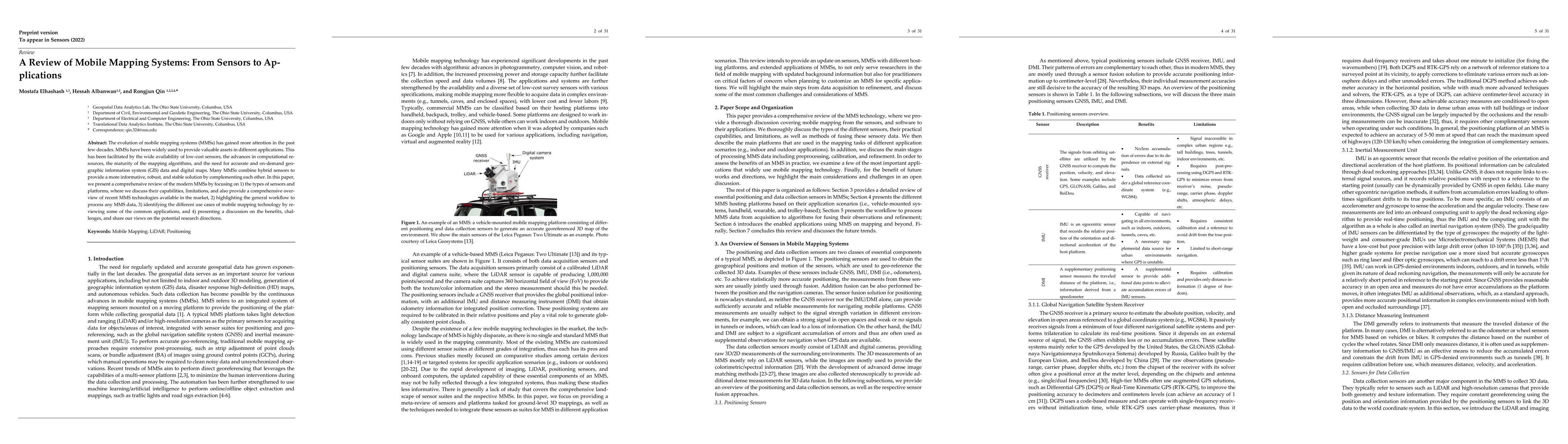
The evolution of mobile mapping systems (MMSs) has gained more attention in the past few decades. MMSs have been widely used to provide valuable assets in different applications. This has been facilitated by the wide availability of low-cost sensors, the advances in computational resources, the maturity of the mapping algorithms, and the need for accurate and on-demand geographic information system (GIS) data and digital maps. Many MMSs combine hybrid sensors to provide a more informative, robust, and stable solution by complementing each other. In this paper, we present a comprehensive review of the modern MMSs by focusing on 1) the types of sensors and platforms, where we discuss their capabilities, limitations, and also provide a comprehensive overview of recent MMS technologies available in the market, 2) highlighting the general workflow to process any MMS data, 3) identifying the different use cases of mobile mapping technology by reviewing some of the common applications, and 4) presenting a discussion on the benefits, challenges, and share our views on the potential research directions.

AI Key Findings

Get AI-generated insights about this paper's methodology, results, and significance.

Paper Details

PDF Preview

Download PDF

Key Terms

sensors (0.265)
mapping (0.238)
mobile (0.208)
comprehensive (0.183)
assets (0.152)
provide (0.151)
gained (0.143)
low cost (0.143)
views (0.142)
highlighting (0.142)
applications (0.136)
availability (0.135)
market (0.134)
platforms (0.131)
demand (0.130)
decades (0.130)
valuable (0.129)
share (0.129)
advances (0.126)
widely used (0.125)

Citation Network

Current paper (gray), citations (green), references (blue)

Current Paper
Citations
References
Click to view

Similar Papers

Found 4 papers
Title Authors Year Actions
Enhanced vehicle localization with low-cost sensor fusion for urban 3D mapping
Sheraz Shamim, S. R. U. N. Jafri
2025
View Paper
LiDAR-Based Road Cracking Detection: Machine Learning Comparison, Intensity Normalization, and Open-Source WebGIS for Infrastructure Maintenance
Nicole Pascucci, D. Dominici, Ayman Habib
2025
View Paper
A Taylor Series Approach to Correction of Input Errors in Gaussian Process Regression
Muzaffar Qureshi, Tochukwu Elijah Ogri, Zachary I. Bell, Wanjiku A. Makumi, R. Kamalapurkar
2025
View Paper
A Taxonomy of Sensors, Calibration and Computational Methods, and Applications of Mobile Mapping Systems: A Comprehensive Review
E. Khoramshahi, S. Nezami, Petri Pellikka, E. Honkavaara, Yuwei Chen, Ayman Habib
2025
View Paper
Interpretation and Understanding of Asphalt Crack Detection Deep Learning Models Using Integrated Gradient (I.G.) Maps
Gihan P. Ruwanpathirana, Sadeep Thilakarathna, S. Baduge
2025
View Paper
Building the Future of Transportation: A Comprehensive Survey on AV Perception, Localization, and Mapping
Ashok Kumar Patil, Bhargav Punugupati, Himanshi Gupta, Niranjan S. Mayur, Srivatsa Ramesh, Prasad B. Honnavalli
2025
View Paper
Evaluation of mobile mapping point clouds in the context of height difference estimation
Markus Wagner, Berit Jost, L. Klingbeil, H. Kuhlmann
2025
View Paper
Analysis of the Qualitative Parameters of Mobile Laser Scanning for the Creation of Cartographic Works and 3D Models for Digital Twins of Urban Areas
Ľ. Kovanič, Patrik Peťovský, Branislav Topitzer, P. Blišťan, Ondrej Tokarčík
2025
View Paper
Generating Seamless Three-Dimensional Maps by Integrating Low-Cost Unmanned Aerial Vehicle Imagery and Mobile Mapping System Data
Mohammad Gholami Gholami Farkoushi, Seunghwan Hong, Hong-Gyoo Sohn
2025
View Paper
Mobile Mapping System for Point Cloud Acquisition in a Forest Environment with an Action Camera
André Pinhal, C. Lázaro, J. A. Gonçalves
2024
View Paper
OR-LIM: Observability-aware robust LiDAR-inertial-mapping under high dynamic sensor motion
Y. Cong, Chi Chen, Bisheng Yang, Ruofei Zhong, Shan Sun, Yuhang Xu, Zhengfei Yan, Xianghong Zou, Zhigang Tu
2024
View Paper
Application of Mobile Mapping System for a Modern Topography
M. Arseni, O. Roman, C. Cucoara, L. P. Georgescu
2024
View Paper
Lane extraction from trajectories at road intersections based on Graph Transformer Network
Chongshan Wan, Peng Yue, Can Yang, Chuanwei Cai, Xiaoxue Liu
2024
View Paper
Harnessing Remote Sensing Technologies for Successful Large-Scale Projects
Josip Lisjak, Matej Petrinović, Stjepan Keleminec
2024
View Paper
3D Reconstruction of Building Blocks Based on Extraction of Exterior Wall Lines Using Point Cloud Density Generated from Spherical Camera Images
Qazale Askari, Hossein Arefi, M. Maboudi
2024
View Paper
Lane Clustering and Fitting with HD map Using the Observations From Vehicle Onboard Sensors
Soohyun Cho, Woojin Chung
2024
View Paper
Vehicle Localization Using Crowdsourced Data Collected on Urban Roads
Soohyun Cho, Woojin Chung
2024
View Paper
Traffic sign detection and recognition based on MMS data using YOLOv4-Tiny algorithm
H. Gezgin, R. M. Alkan
2024
View Paper
Adaptive Multi-Loss GAN for Object Removals in Street-View Scenes
Arzeezar Lording, Luepol Pipanmaekaporn, Suwatchai Kamonsantiroj, K. Srisomboon
2024
View Paper
Enhancement of High-Definition Map for Autonomous Vehicle Application by Light Intensity Equalization Technique
Pattarapoom Nokkaew, N. Sutthisangiam
2024
View Paper
A Comprehensive Survey on High-Definition Map Generation and Maintenance
Kaleab Taye Asrat, Hyung-Ju Cho
2024
View Paper
Ant3D—A Fisheye Multi-Camera System to Survey Narrow Spaces
L. Perfetti, Francesco Fassi, G. Vassena
2024
View Paper
Accuracy of Determination of Corresponding Points from Available Providers of Spatial Data—A Case Study from Slovakia
S. Labant, Patrik Peťovský, Pavel Sustek, Lubomir Leicher
2024
View Paper
YUTO MMS: A comprehensive SLAM dataset for urban mobile mapping with tilted LiDAR and panoramic camera integration
Yiujia Zhang, SeyedMostafa Ahmadi, Jungwon Kang, Z. Arjmandi, Gunho Sohn
2024
View Paper
Multi-Sensor Geomatic Techniques for the 3D Documentation and Virtual Repositioning of Elements of the Church of S. Miguel (Jaén, Spain)
A. Mozas-Calvache, J. M. Gómez-López, José Luis Pérez-García, D. Vico-García, V. Barba-Colmenero, Alberto Fernández-Ordóñez
2024
View Paper
Automating Built Heritage Modelling for the Integration into 3D City Models
Ali Aboohamzeh, M. Avena, Antonia Spanò
2024
View Paper
Civil Integrated Management (CIM) for Advanced Level Applications to Transportation Infrastructure: A State-of-the-Art Review
Ali Taheri, John Sobanjo
2024
View Paper
GAN-Driven Vehicle Inpainting for Mobile Mapping Scenes
Arzeezar Lording, Luepol Pipanmaekaporn, Suwatchai Kamonsantiroj, K. Srisomboon
2024
View Paper
Multi-source point cloud registration for urban areas using a coarse-to-fine approach
Eun-Tak Lee, Youngmok Kwon, Cheolhwan Kim, Wonjun Choi, Hong-Gyoo Sohn
2024
View Paper
ACCURACY ASSESSMENT OF A SLAM-ACQUIRED POINT CLOUD DATA USING A VARIETY OF CLASSIFICATION APPLICATIONS
H. A. Ingles, A. M. M. Legaspi, C. J. S. Sarmiento, A. R. Claridades
2024
View Paper
Digital Twins and Civil Engineering Phases: Reorienting Adoption Strategies
Taiwo A. Adebiyi, Nafeezat A. Ajenifuja, Ruda Zhang
2024
View Paper
Mobile mapping system for historic built heritage and GIS integration: a challenging case study
D. Treccani, A. Adami, Valerio Brunelli, L. Fregonese
2024
View Paper
A COMPARISON BETWEEN TERRESTRIAL LASER SCANNING AND HAND-HELD MOBILE MAPPING FOR THE DOCUMENTATION OF BUILT HERITAGE
A. Conti, G. Pagliaricci, V. Bonora, G. Tucci
2024
View Paper
Remote Sensing-Based 3D Assessment of Landslides: A Review of the Data, Methods, and Applications
H. Albanwan, Rongjun Qin, Jung-Kuan Liu
2024
View Paper
Comparing Mobile and Aerial Laser Scanner point cloud data sets for automating the detection and delimitation procedure of safety-critical near-road slopes
Antón Núñez-Seoane, J. Martínez-Sánchez, Erik Rúa, Pedro Arias
2024
View Paper
Enhancement of low-cost UAV-based photogrammetric point cloud using MMS point cloud and oblique images for 3D urban reconstruction
Eun-Tak Lee, Soyeon Park, H. Jang, Wonjun Choi, Hong-Gyoo Sohn
2024
View Paper
Rapid Geometric Evaluation of Transportation Infrastructure Based on a Proposed Low-Cost Portable Mobile Laser Scanning System
Haochen Wang, Dongming Feng
2024
View Paper
3D Road Boundary Extraction Based on Machine Learning Strategy Using LiDAR and Image-Derived MMS Point Clouds
B. Suleymanoglu, M. Soycan, C. Toth
2024
View Paper
Generating lane-level road networks from high-precision trajectory data with lane-changing behavior analysis
Mengyue Yuan, Peng Yue, Can Yang, Jian Li, Kai Yan, Chuanwei Cai, Chongshan Wan
2023
View Paper
MIN3D Dataset: MultI-seNsor 3D Mapping with an Unmanned Ground Vehicle
P. Trybała, J. Szrek, F. Remondino, Paulina Kujawa, J. Wodecki, J. Blachowski, Radosław Zimroz
2023
View Paper
Multi-Sensor HR Mass Data Models toward Multi-Temporal-Layered Digital Twins: Maintenance, Design and XR Informed Tour of the Multi-Stratified Appian Way (PAAA)
R. Brumana, Simone Quilici, Luigi Oliva, M. Previtali, Marzia Gabriele, C. Stanga
2023
View Paper
Lane-Level Map Generation and Management Framework Using Connected Car Data
Junyeong Kim, Jeongmin Moon, Changjoo Moon
2023
View Paper
Solid-State-LiDAR-Inertial-Visual Odometry and Mapping via Quadratic Motion Model and Reflectivity Information
Tao Yin, Jingzheng Yao, Yan Lu, Chunrui Na
2023
View Paper
Multiscale 3D Documentation of the Medieval Wall of Jaén (Spain) Based on Multi-Sensor Data Fusion
José Luis Pérez-García, A. Mozas-Calvache, J. M. Gómez-López, D. Vico-García
2023
View Paper
A review on the impacts of connected vehicles on pavement management systems
Mohammad Saleh Entezari, A. Golroo
2023
View Paper
Accuracy and inter-cloud precision of low-cost mobile LiDAR technology in estimating soil disturbance in forest operations
Gabriel Osei Forkuo, S. A. Borz
2023
View Paper
Gamification for road asset inspection from Mobile Mapping System data
Álvaro Barros-Sobrín, J. Balado, M. Soilán, Enrique Mingueza-Bauzá
2023
View Paper
PVL-Cartographer: Panoramic Vision-Aided LiDAR Cartographer-Based SLAM for Maverick Mobile Mapping System
Yujia Zhang, Jungwon Kang, G. Sohn
2023
View Paper
Camera-Aided Orientation of Mobile Lidar Point Clouds Acquired from an Uncrewed Water Vehicle
H. Sardemann, R. Blaskow, H. Maas
2023
View Paper
Comparison of Unmanned Aerial Vehicle-LiDAR and Image-Based Mobile Mapping System for Assessing Road Geometry Parameters via Digital Terrain Models
B. Suleymanoglu, Mert Gurturk, Y. Yılmaz, Arzu Soycan, M. Soycan
2023
View Paper
Can the Perception Data of Autonomous Vehicles Be Used to Replace Mobile Mapping Surveys? - A Case Study Surveying Roadside City Trees
Eric Hyyppä, P. Manninen, Jyri Maanpää, Josef Taher, P. Litkey, H. Hyyti, A. Kukko, H. Kaartinen, E. Ahokas, Xiaowei Yu, Jesse Muhojoki, M. Lehtomäki, Juho-Pekka Virtanen, J. Hyyppä
2023
View Paper
Empirical Analysis of Autonomous Vehicle’s LiDAR Detection Performance Degradation for Actual Road Driving in Rain and Fog
Jiyoon Kim, Bumjin Park, Jisoo Kim
2023
View Paper
Towards Automated Inspections of Tunnels: A Review of Optical Inspections and Autonomous Assessment of Concrete Tunnel Linings
A. Sjölander, V. Belloni, A. Ansell, Erik Nordström
2023
View Paper
HDPV-SLAM: Hybrid Depth-Augmented Panoramic Visual SLAM for Mobile Mapping System with Tilted LiDAR and Panoramic Visual Camera
Mostafa Ahmadi, A. A. Naeini, Z. Arjmandi, Yujia Zhang, M. Sheikholeslami, G. Sohn
2023
View Paper
From Stationary to Mobile: Unleashing the Full Potential of Terrestrial LiDAR through Sensor Integration
Hamdy Elsayed, Ahmed Shaker
2023
View Paper
CAOM: Change-aware online 3D mapping with heterogeneous multi-beam and push-broom LiDAR point clouds
Y. Cong, Chi Chen, Bisheng Yang, Fuxun Liang, Ruiqi Ma, Fei Zhang
2023
View Paper
Application of Mobile Mapping System to a Cable-Stayed Bridge in Thailand
E. Lueangvilai, T. Chaisomphob
2022
View Paper
道路・路肩の積雪計測を目的とした低コスト車両搭載MMSの開発のための基礎検討
Kazuyoshi Takahashi, Takeshi Nakamura, Yoshimichi Senda
2024
View Paper
Improvement of Precise Vehicle Location in Urban Areas Using Video-based Photogrammetry
André Pinhal, J. A. Gonçalves
2024
View Paper
Automatic Registration of Panoramic Image and Point Cloud Based on the Shape of the Overall Ground Object
Buyun Wang, Hongwei Li, Shan Zhao, Linqing He, Yulu Qin, Xiaoyue Yang
2023
View Paper
High-Definition Maps: Comprehensive Survey, Challenges, and Future Perspectives
Gamal Elghazaly, R. Frank, Scott Harvey, Stefan Safko
2023
View Paper
Automated 3D Mapping, Localization and Pavement Inspection with Low Cost RGB-D Cameras and IMUs
N. Anvo, T. G. Thuruthel, Hussameldin M. Taha, Lavindra de Silva, A. Al-Tabbaa, Ioannis K. Brilakis, Fumiya Iida
2023
View Paper
A systematic literature review of low-cost 3D mapping solutions
J. Balado, R. Garozzo, Lukas Winiwarter, Sofia Tilon
View Paper

Comments (0)

This website uses cookies to ensure you get the best experience. Learn more