The research presents a novel approach to LiDAR-inertial odometry by integrating a simplified motion model with adaptive regularization techniques. It combines IMU data averaging and ICP-based LiDAR scan registration, validated across multiple public datasets and real-world scenarios.
A Robust Approach for LiDAR-Inertial Odometry Without Sensor-Specific Modeling
Publication
Metrics
Quick Answers
What methodology did the authors use?
The research presents a novel approach to LiDAR-inertial odometry by integrating a simplified motion model with adaptive regularization techniques. It combines IMU data averaging and ICP-based LiDAR scan registration, validated across multiple public datasets and real-world scenarios. More in Methodology →
What are the key results?
Achieves state-of-the-art performance on diverse datasets including HeLiPR, DigiForests, and Oxford Spires — Demonstrates faster processing than sensor frame rate across all tested datasets More in Key Results →
Why is this work significant?
This work advances autonomous navigation systems by providing a reliable, accurate, and efficient odometry solution that works with various LiDAR-IMU configurations, enabling better robot localization and mapping in complex environments. More in Significance →
What are the main limitations?
Limited evaluation on non-standard sensor setups — Assumes uniform sensor resolution without adaptive handling More in Limitations →
Abstract
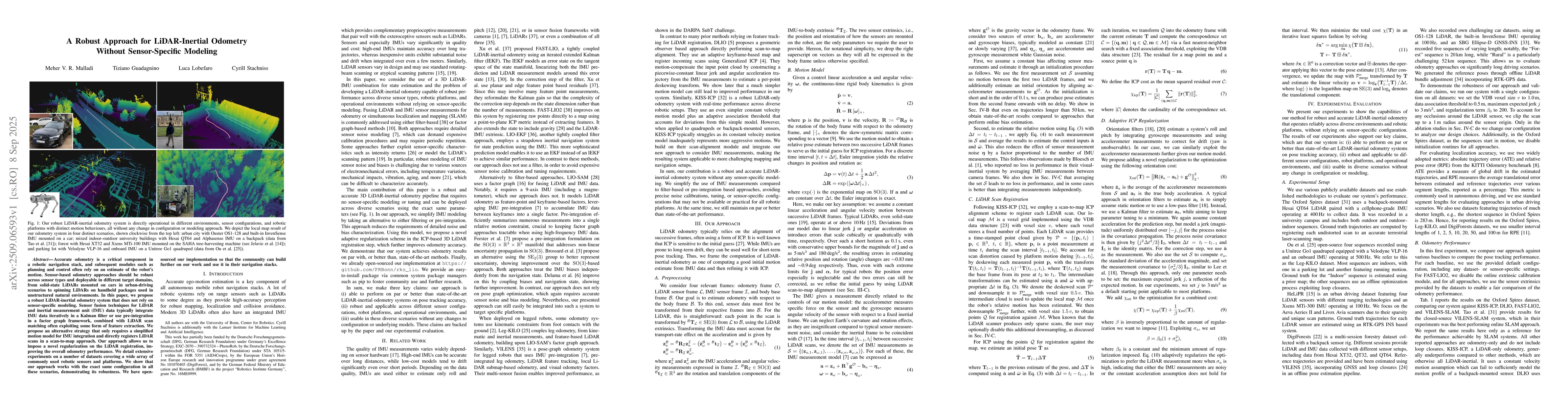
Accurate odometry is a critical component in a robotic navigation stack, and subsequent modules such as planning and control often rely on an estimate of the robot's motion. Sensor-based odometry approaches should be robust across sensor types and deployable in different target domains, from solid-state LiDARs mounted on cars in urban-driving scenarios to spinning LiDARs on handheld packages used in unstructured natural environments. In this paper, we propose a robust LiDAR-inertial odometry system that does not rely on sensor-specific modeling. Sensor fusion techniques for LiDAR and inertial measurement unit (IMU) data typically integrate IMU data iteratively in a Kalman filter or use pre-integration in a factor graph framework, combined with LiDAR scan matching often exploiting some form of feature extraction. We propose an alternative strategy that only requires a simplified motion model for IMU integration and directly registers LiDAR scans in a scan-to-map approach. Our approach allows us to impose a novel regularization on the LiDAR registration, improving the overall odometry performance. We detail extensive experiments on a number of datasets covering a wide array of commonly used robotic sensors and platforms. We show that our approach works with the exact same configuration in all these scenarios, demonstrating its robustness. We have open-sourced our implementation so that the community can build further on our work and use it in their navigation stacks.
Key Findings, in focus
Seven facets of this paper, analysed and brought into focus by AI.
This work advances autonomous navigation systems by providing a reliable, accurate, and efficient odometry solution that works with various LiDAR-IMU configurations, enabling better robot localization and mapping in complex environments.
- Achieves state-of-the-art performance on diverse datasets including HeLiPR, DigiForests, and Oxford Spires
- Demonstrates faster processing than sensor frame rate across all tested datasets
- Shows improved robustness through adaptive regularization and motion model integration
This work advances autonomous navigation systems by providing a reliable, accurate, and efficient odometry solution that works with various LiDAR-IMU configurations, enabling better robot localization and mapping in complex environments.
Proposes an adaptive regularization method for ICP-based LiDAR scan registration that leverages a simplified motion model to reduce noise while maintaining performance
Combines IMU data averaging with motion model-based regularization in LiDAR odometry, offering a new approach that improves accuracy without sacrificing computational efficiency
- Limited evaluation on non-standard sensor setups
- Assumes uniform sensor resolution without adaptive handling
- Explore application on more heterogeneous sensor systems
- Investigate integration with higher-level SLAM systems
Discussion 0