Agentic AI for Remote Sensing: Technical Challenges and Research Directions
Publication
Metrics
AI Quick Summary
The paper argues that applying generic agentic AI to Earth Observation is flawed because geospatial data involve transformations (reprojection, resampling, etc.) that affect later steps and must maintain geospatial and physical validity. It proposes EO-native agent designs that track structured geospatial state, tool-aware reasoning, and verifier-guided execution, plus research directions for EO-specific benchmarks and learning methods to ensure reliable, trajectory-consistent analysis.
Paper Preview
Abstract
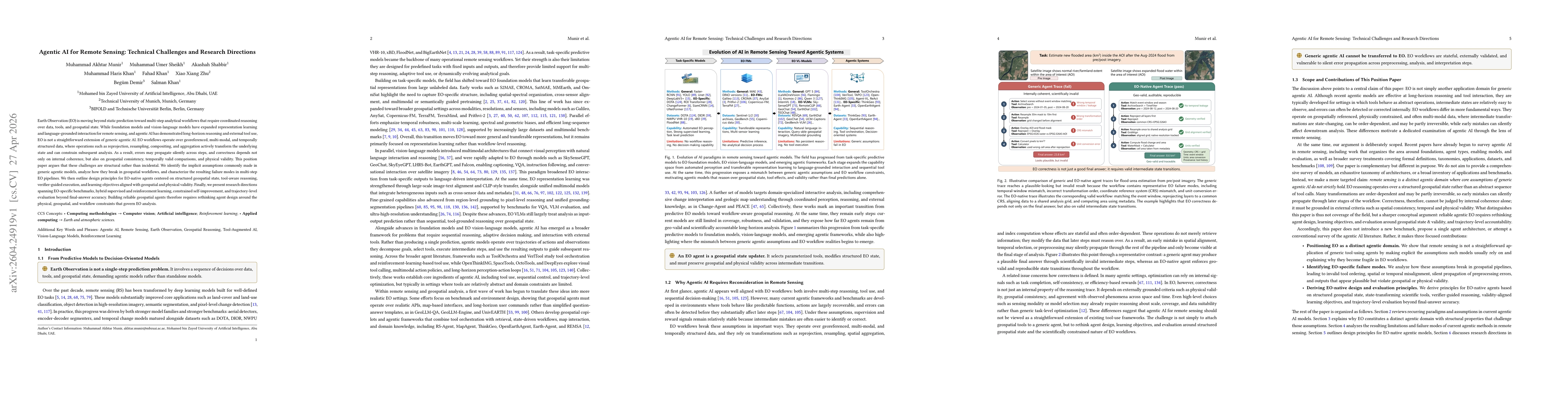
Earth Observation (EO) is moving beyond static prediction toward multi-step analytical workflows that require coordinated reasoning over data, tools, and geospatial state. While foundation models and vision-language models have expanded representation learning and language-grounded interaction for remote sensing, and agentic AI has demonstrated long-horizon reasoning and external tool use, EO is not a straightforward extension of generic agentic AI. EO workflows operate over georeferenced, multi-modal, and temporally structured data, where operations such as reprojection, resampling, compositing, and aggregation actively transform the underlying state and can constrain subsequent analysis. As a result, errors may propagate silently across steps, and correctness depends not only on internal coherence, but also on geospatial consistency, temporally valid comparisons, and physical validity. This position paper argues that these challenges are structural rather than incidental. We identify the implicit assumptions commonly made in generic agentic models, analyze how they break in geospatial workflows, and characterize the resulting failure modes in multi-step EO pipelines. We then outline design principles for EO-native agents centered on structured geospatial state, tool-aware reasoning, verifier-guided execution, and learning objectives aligned with geospatial and physical validity. Finally, we present research directions spanning EO-specific benchmarks, hybrid supervised and reinforcement learning, constrained self-improvement, and trajectory-level evaluation beyond final-answer accuracy. Building reliable geospatial agents therefore requires rethinking agent design around the physical, geospatial, and workflow constraints that govern EO analysis.
AI Key Findings
Get AI-generated insights about this paper's methodology, results, significance, and more — seven facets brought into focus.
Discussion 0