Academic Profile
Statistics
Similar Authors
Papers on arXiv
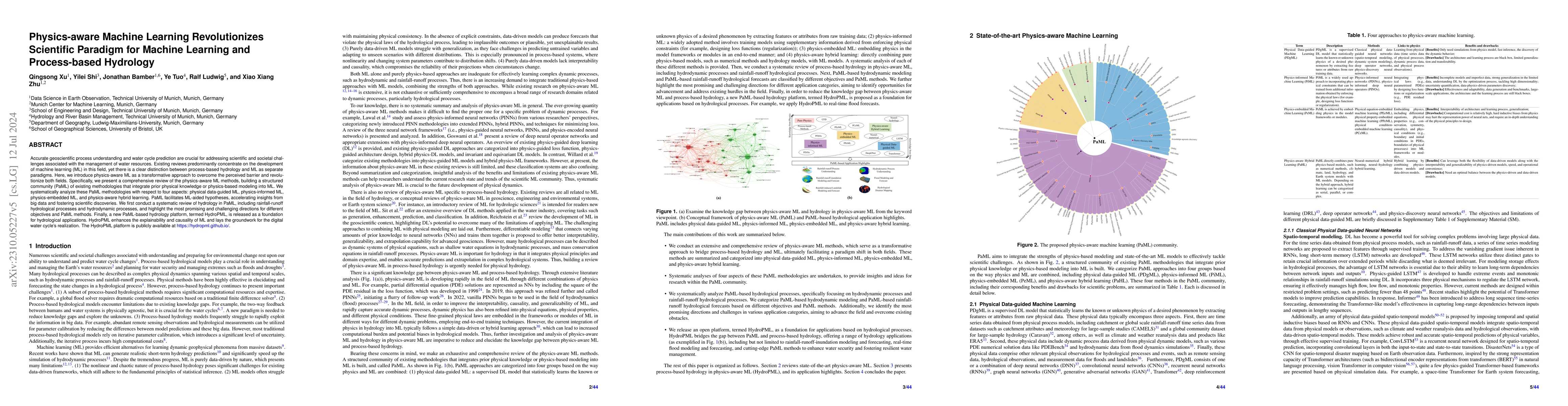
Accurate hydrological understanding and water cycle prediction are crucial for addressing scientific and societal challenges associated with the management of water resources, particularly under the d...
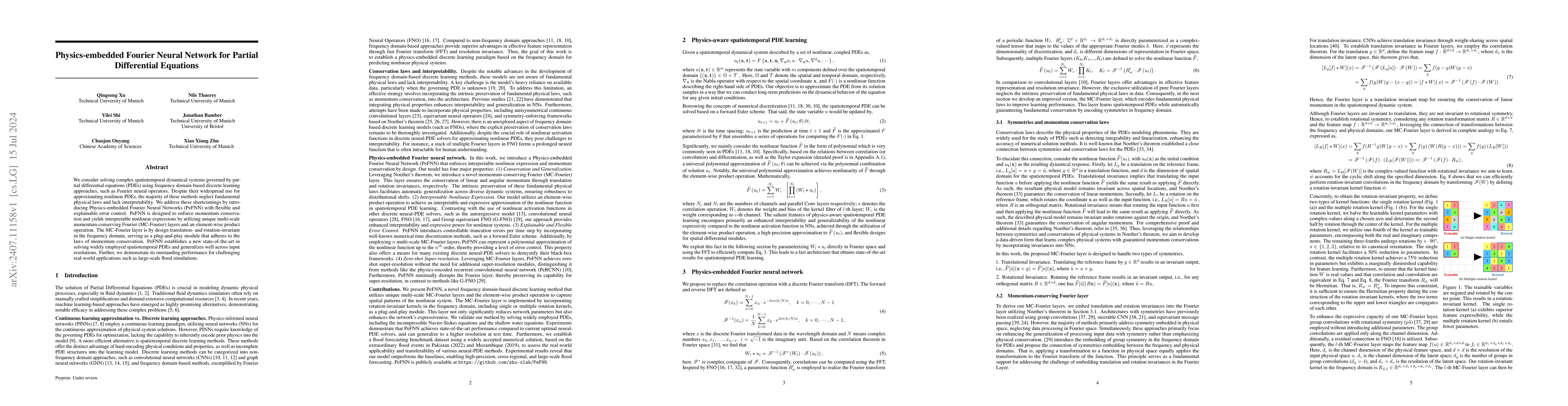
We consider solving complex spatiotemporal dynamical systems governed by partial differential equations (PDEs) using frequency domain-based discrete learning approaches, such as Fourier neural operato...
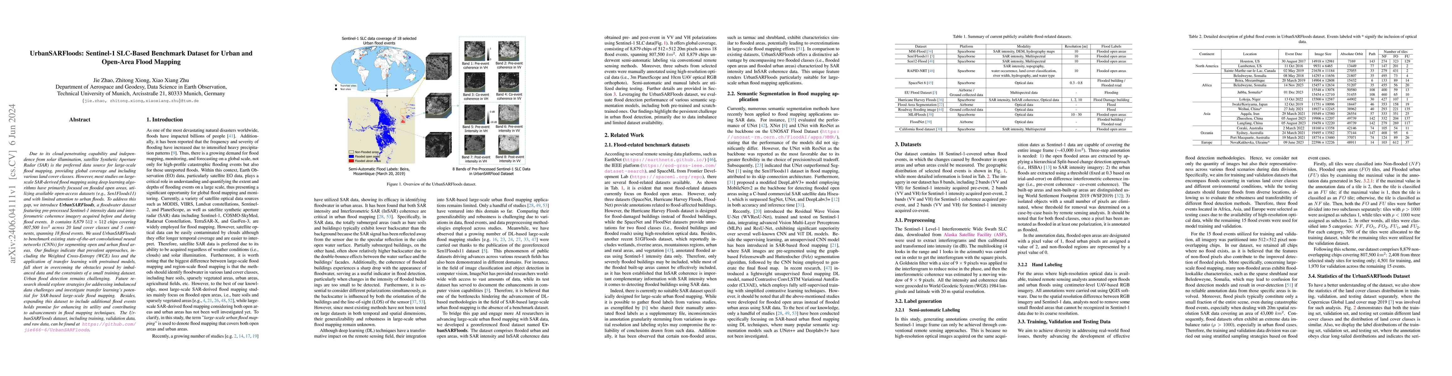
Due to its cloud-penetrating capability and independence from solar illumination, satellite Synthetic Aperture Radar (SAR) is the preferred data source for large-scale flood mapping, providing globa...
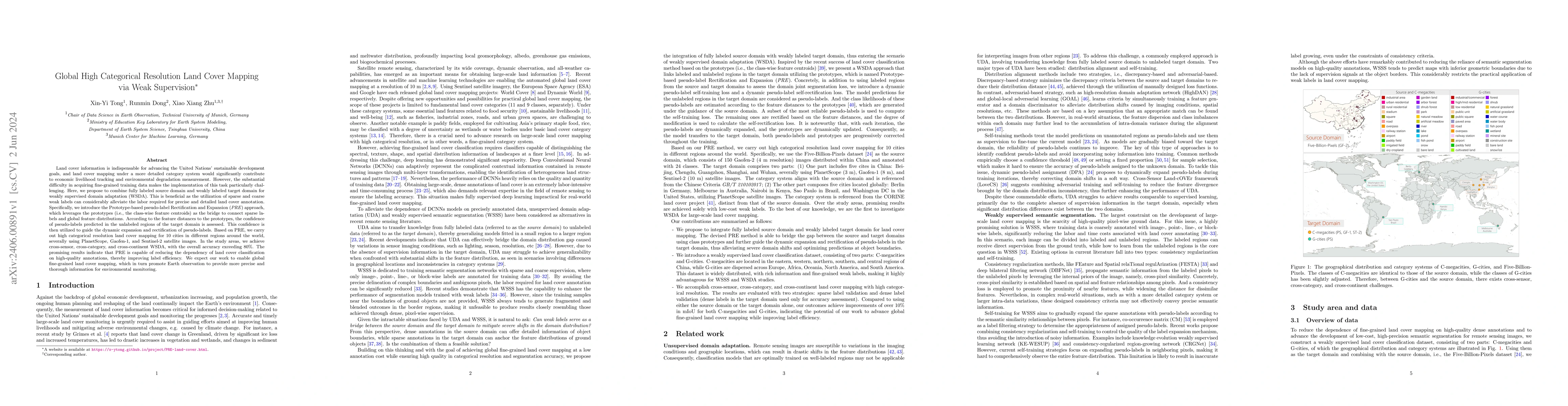
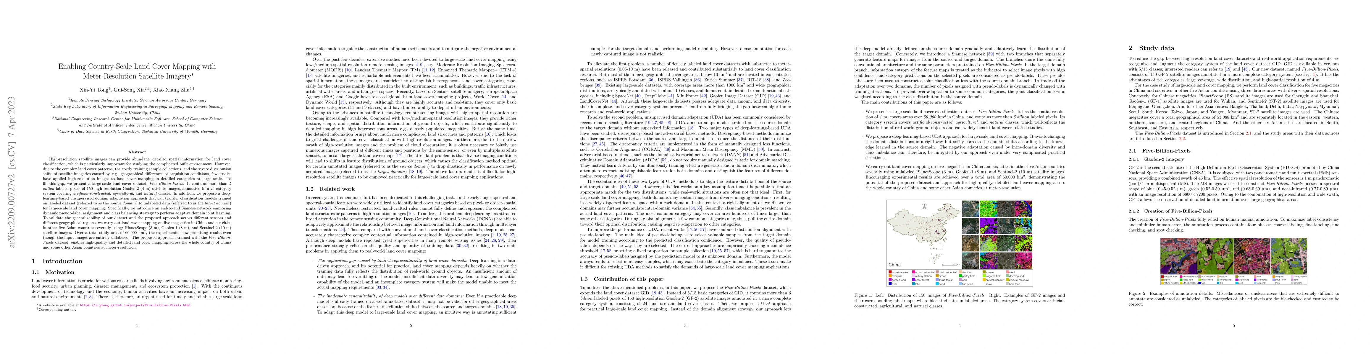
Land cover information is indispensable for advancing the United Nations' sustainable development goals, and land cover mapping under a more detailed category system would significantly contribute t...
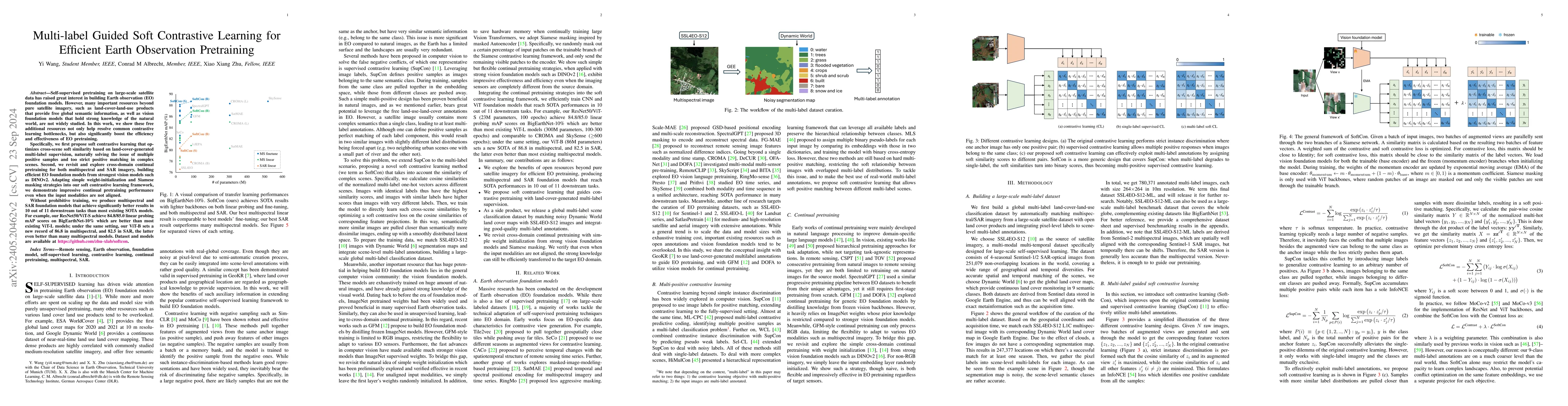
Self-supervised pretraining on large-scale satellite data has raised great interest in building Earth observation (EO) foundation models. However, many important resources beyond pure satellite imag...
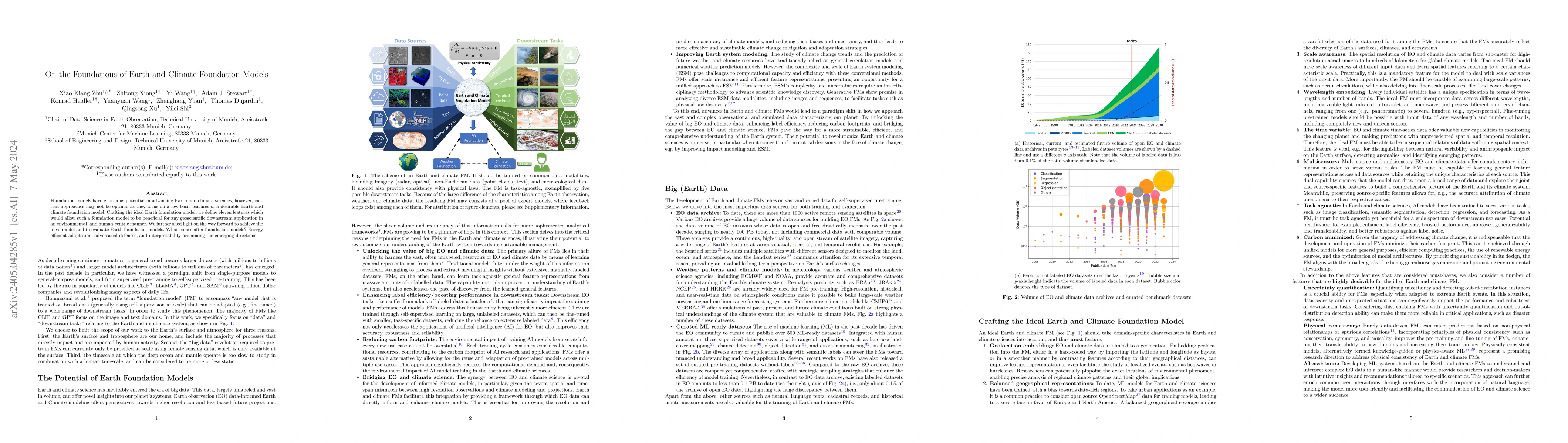
Foundation models have enormous potential in advancing Earth and climate sciences, however, current approaches may not be optimal as they focus on a few basic features of a desirable Earth and clima...
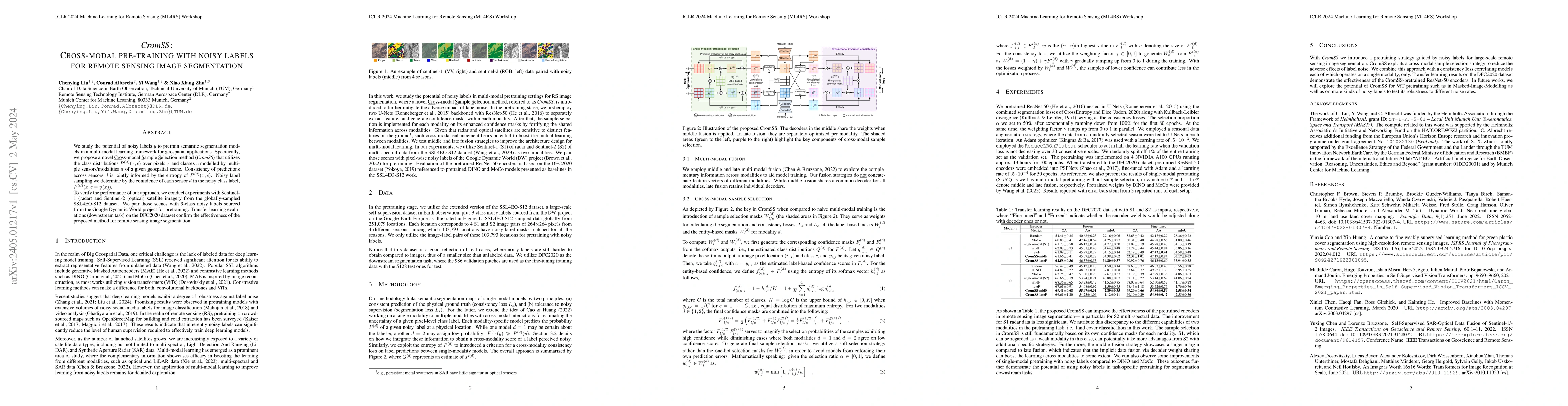
We study the potential of noisy labels y to pretrain semantic segmentation models in a multi-modal learning framework for geospatial applications. Specifically, we propose a novel Cross-modal Sample...
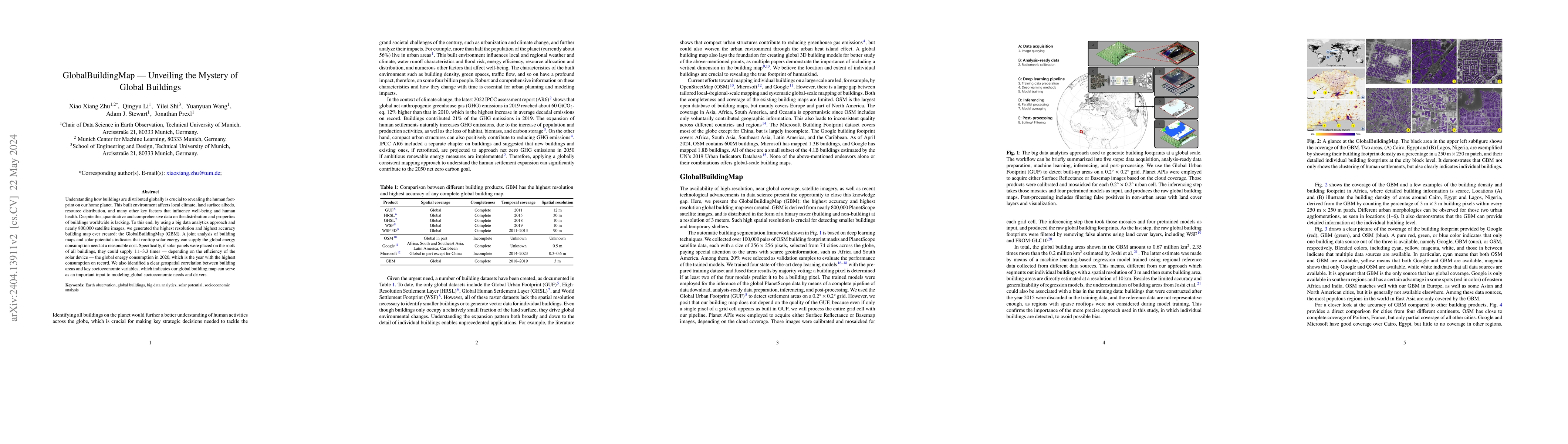
Understanding how buildings are distributed globally is crucial to revealing the human footprint on our home planet. This built environment affects local climate, land surface albedo, resource distr...
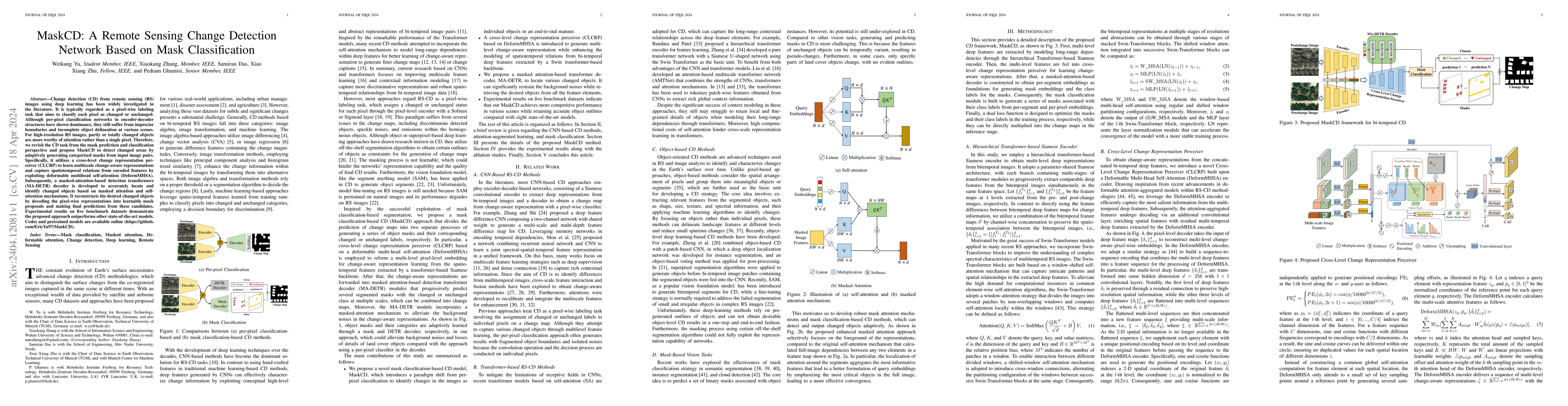
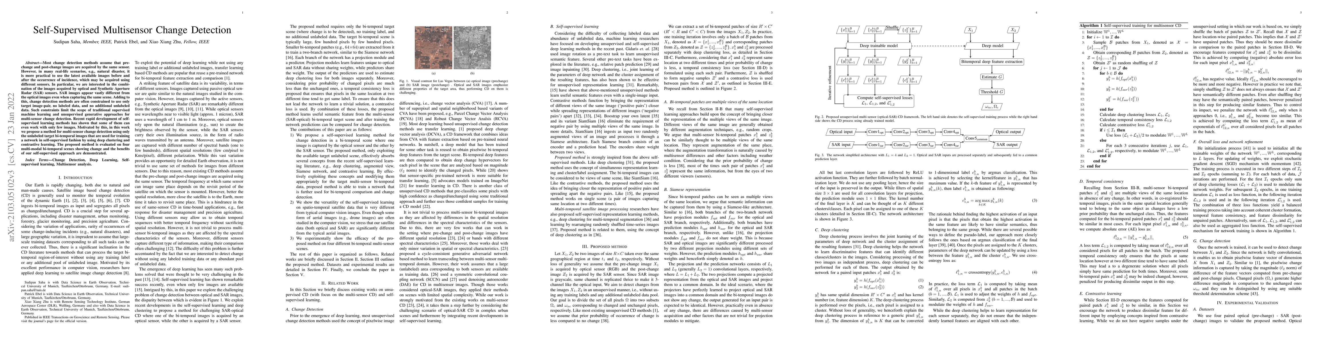
Change detection (CD) from remote sensing (RS) images using deep learning has been widely investigated in the literature. It is typically regarded as a pixel-wise labeling task that aims to classify...
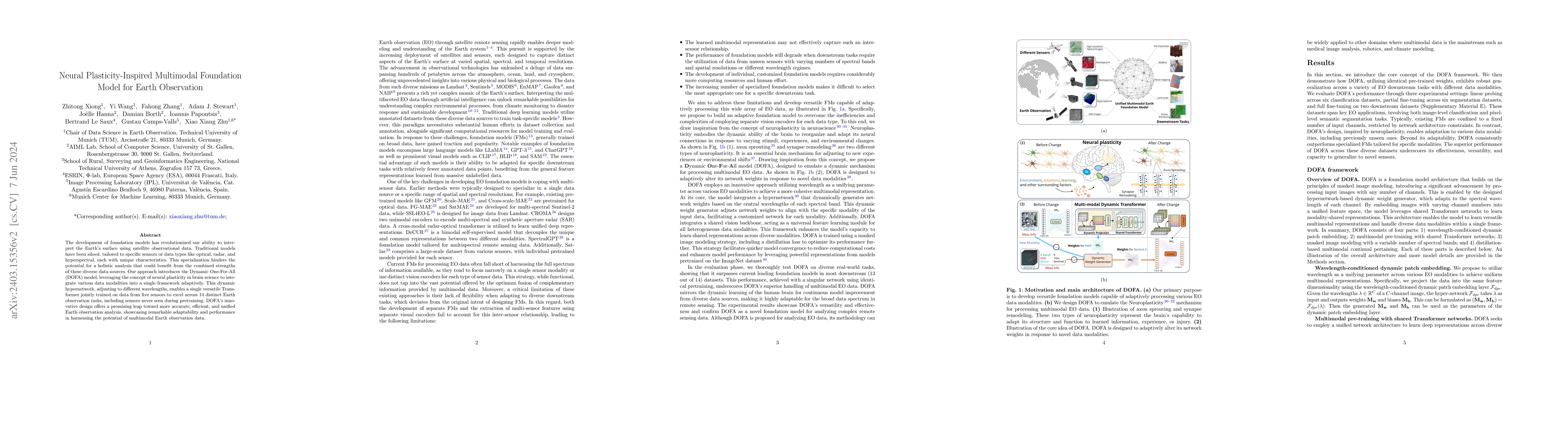
The development of foundation models has revolutionized our ability to interpret the Earth's surface using satellite observational data. Traditional models have been siloed, tailored to specific sen...
Large-scale hydrodynamic models generally rely on fixed-resolution spatial grids and model parameters as well as incurring a high computational cost. This limits their ability to accurately forecast...

Wildfire forecasting is notoriously hard due to the complex interplay of different factors such as weather conditions, vegetation types and human activities. Deep learning models show promise in dea...
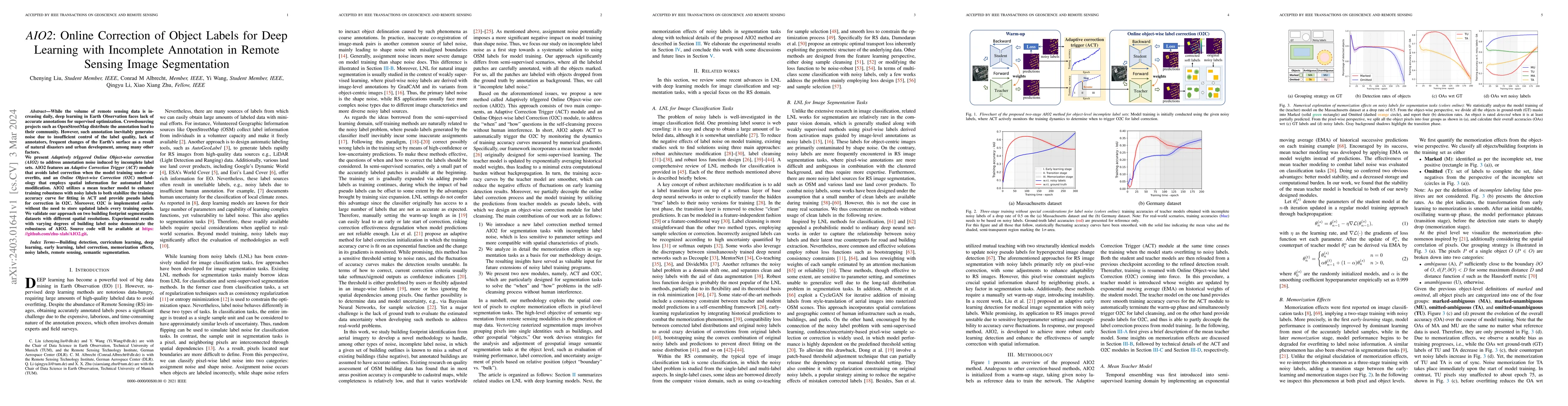
While the volume of remote sensing data is increasing daily, deep learning in Earth Observation faces lack of accurate annotations for supervised optimization. Crowdsourcing projects such as OpenStr...
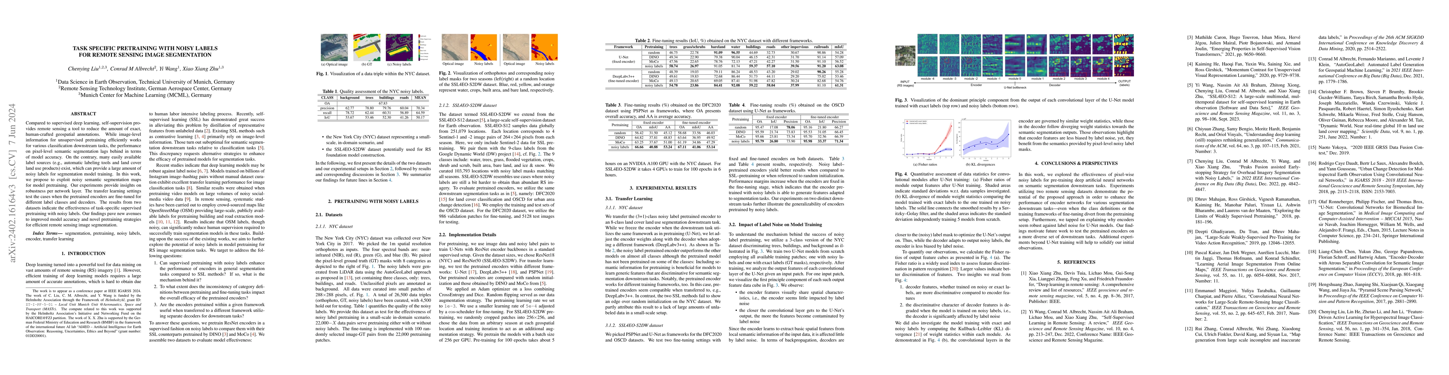
Compared to supervised deep learning, self-supervision provides remote sensing a tool to reduce the amount of exact, human-crafted geospatial annotations. While image-level information for unsupervi...
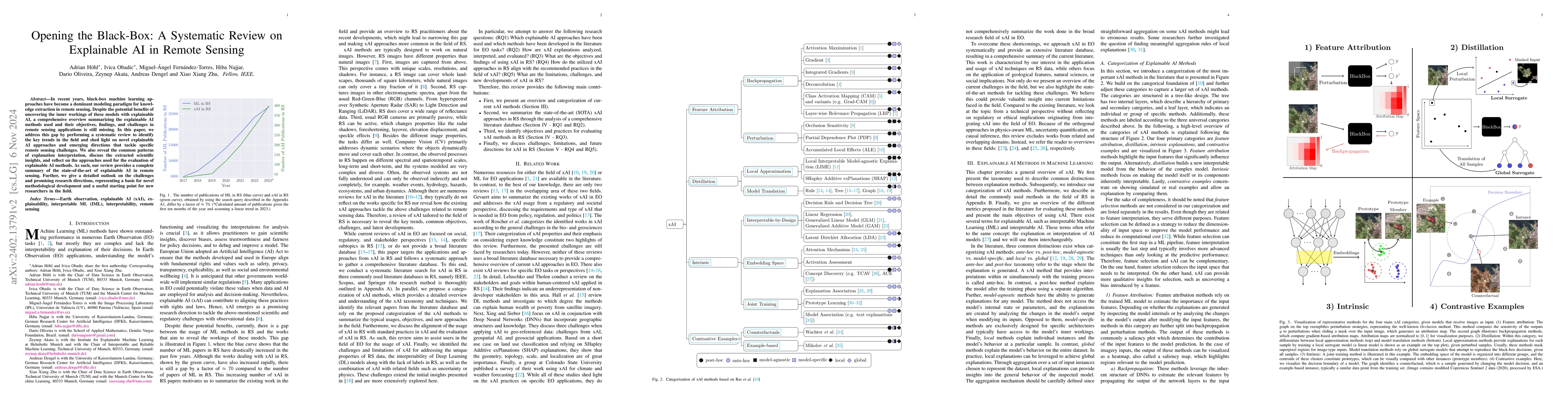
In recent years, black-box machine learning approaches have become a dominant modeling paradigm for knowledge extraction in Remote Sensing. Despite the potential benefits of uncovering the inner wor...
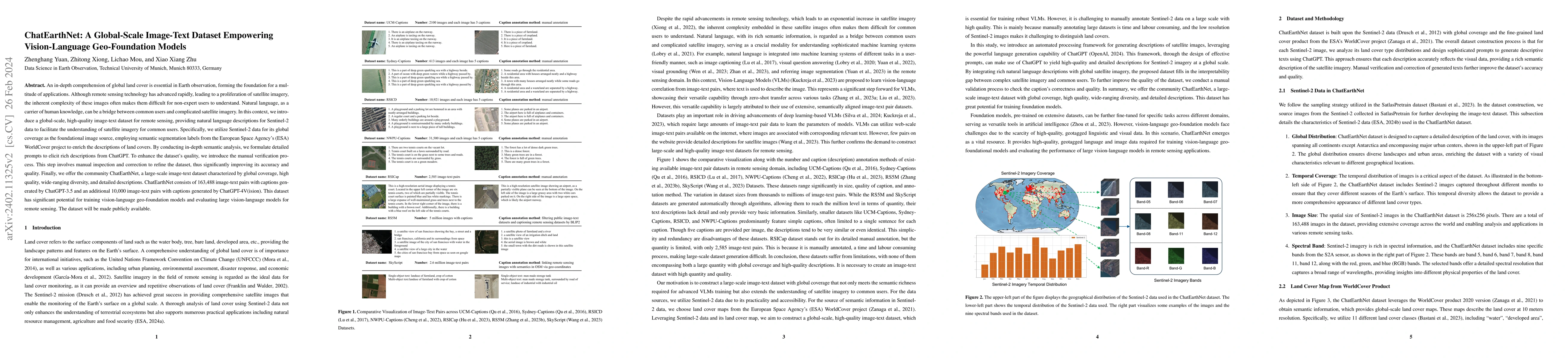
An in-depth comprehension of global land cover is essential in Earth observation, forming the foundation for a multitude of applications. Although remote sensing technology has advanced rapidly, lea...
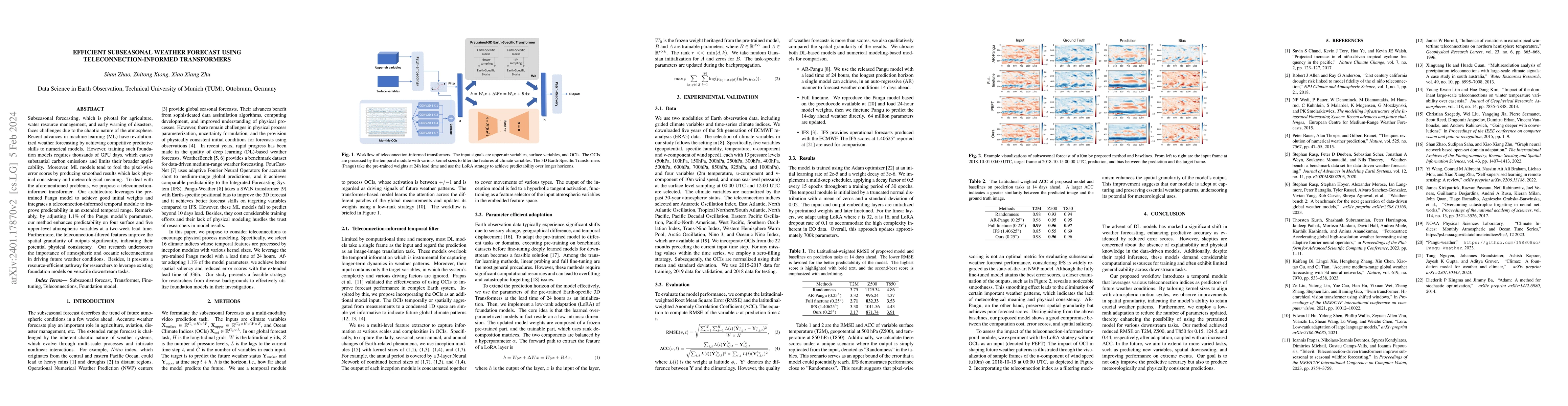
Subseasonal forecasting, which is pivotal for agriculture, water resource management, and early warning of disasters, faces challenges due to the chaotic nature of the atmosphere. Recent advances in...
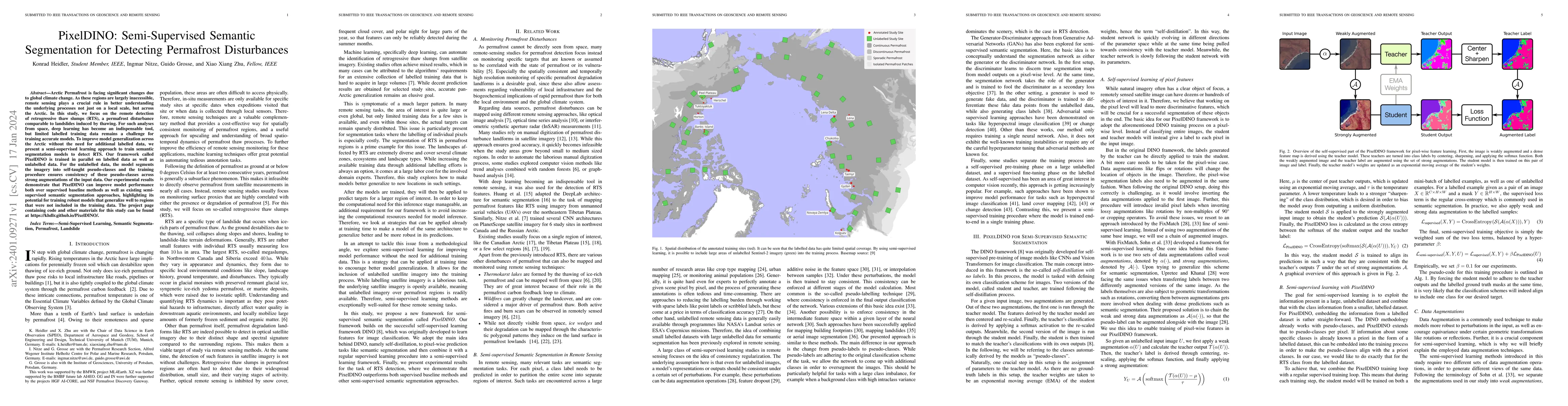
Arctic Permafrost is facing significant changes due to global climate change. As these regions are largely inaccessible, remote sensing plays a crucial rule in better understanding the underlying pr...
Foundation models characterized by extensive parameters and trained on large-scale datasets have demonstrated remarkable efficacy across various downstream tasks for remote sensing data. Current rem...
Uncertainty in machine learning models is a timely and vast field of research. In supervised learning, uncertainty can already occur in the first stage of the training process, the annotation phase....
Self-supervised learning guided by masked image modelling, such as Masked AutoEncoder (MAE), has attracted wide attention for pretraining vision transformers in remote sensing. However, MAE tends to...
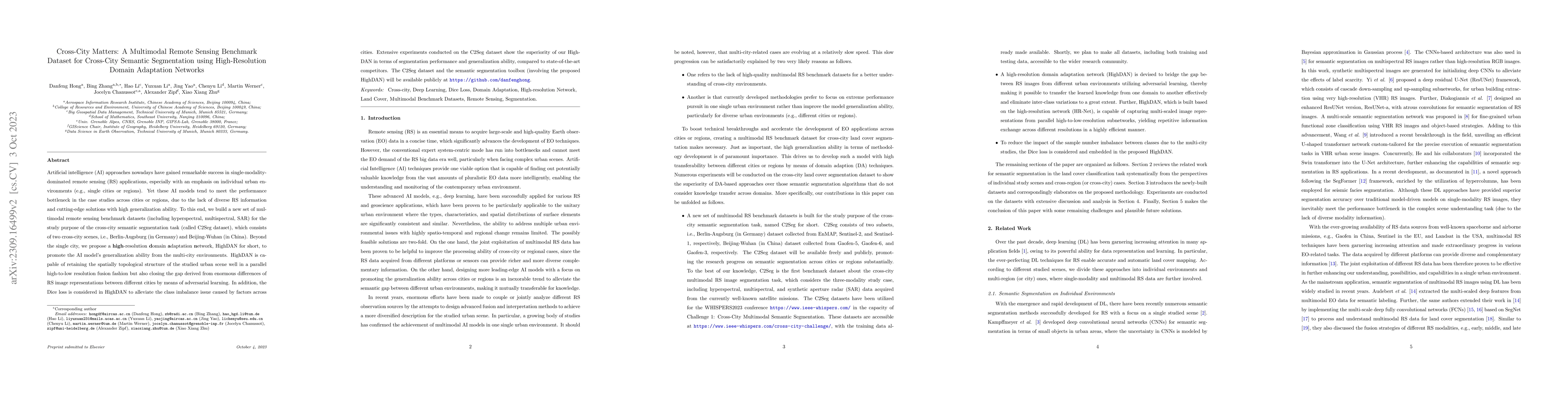
Artificial intelligence (AI) approaches nowadays have gained remarkable success in single-modality-dominated remote sensing (RS) applications, especially with an emphasis on individual urban environ...
3D geo-information is of great significance for understanding the living environment; however, 3D perception from remote sensing data, especially on a large scale, is restricted. To tackle this prob...
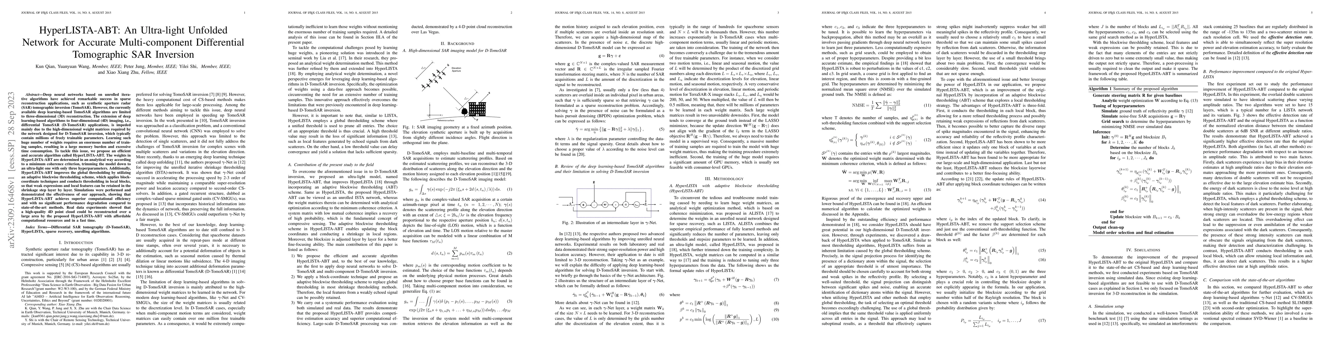
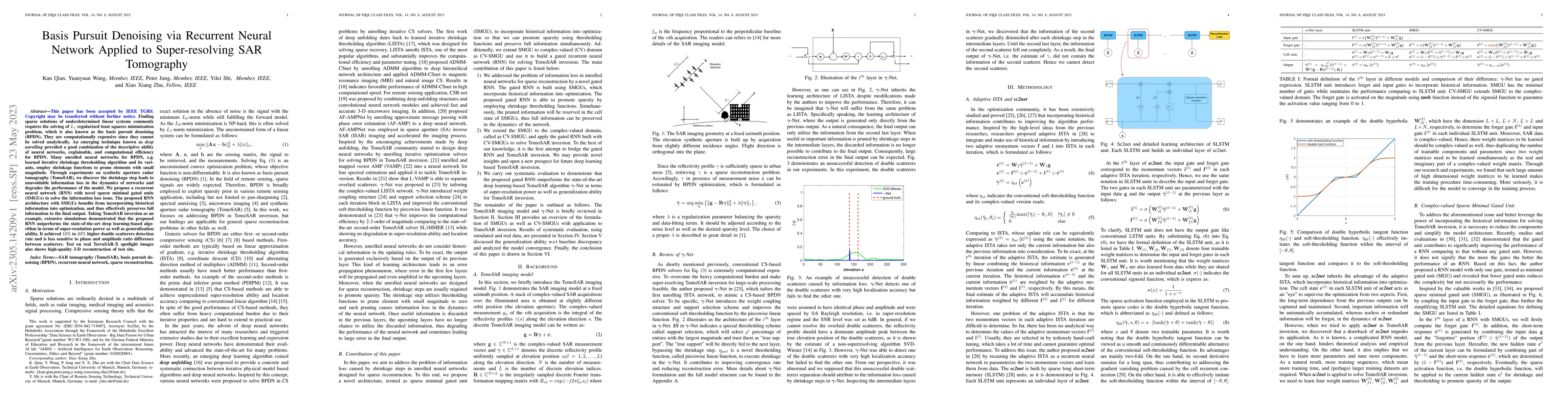
Deep neural networks based on unrolled iterative algorithms have achieved remarkable success in sparse reconstruction applications, such as synthetic aperture radar (SAR) tomographic inversion (Tomo...
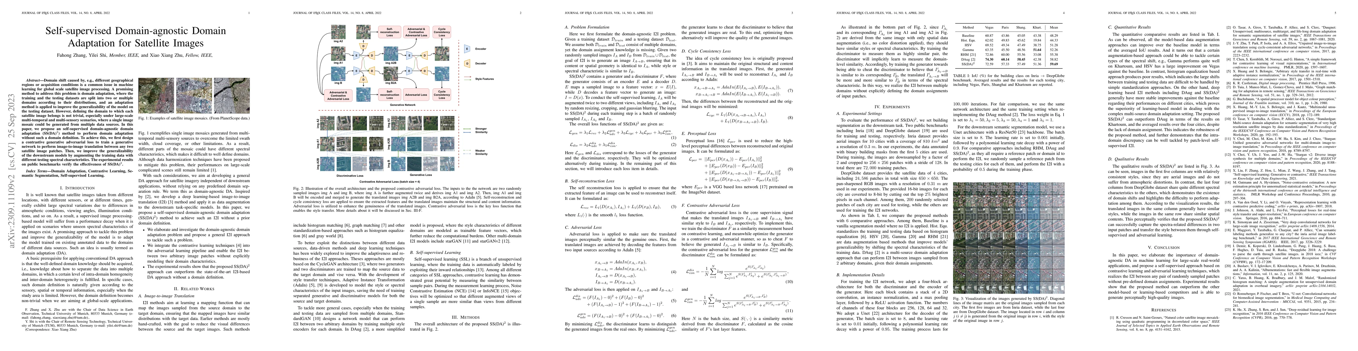
Domain shift caused by, e.g., different geographical regions or acquisition conditions is a common issue in machine learning for global scale satellite image processing. A promising method to addres...
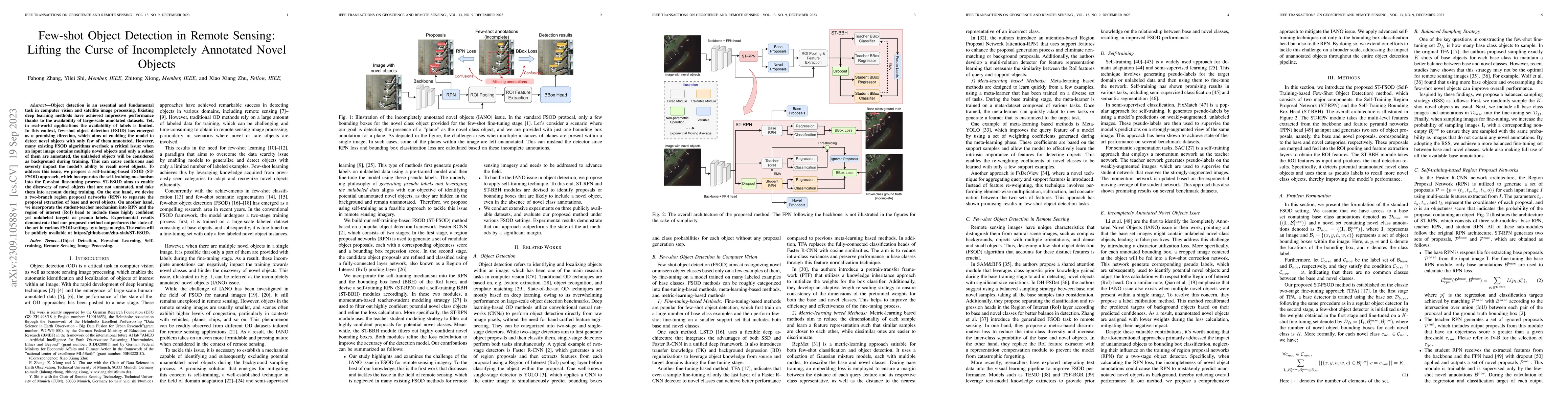
Object detection is an essential and fundamental task in computer vision and satellite image processing. Existing deep learning methods have achieved impressive performance thanks to the availabilit...
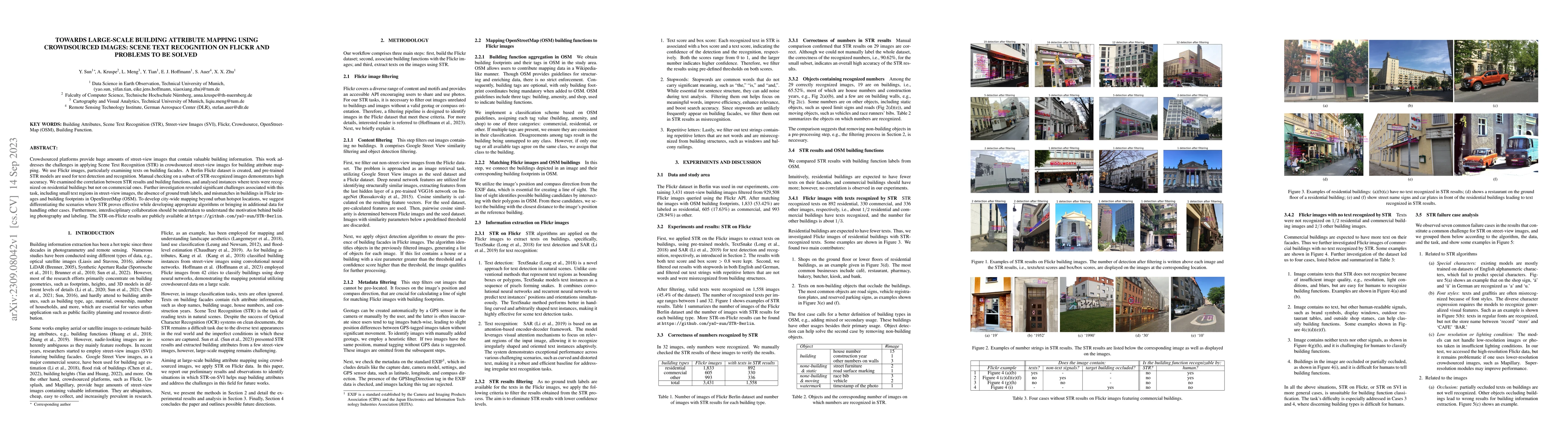
Crowdsourced platforms provide huge amounts of street-view images that contain valuable building information. This work addresses the challenges in applying Scene Text Recognition (STR) in crowdsour...
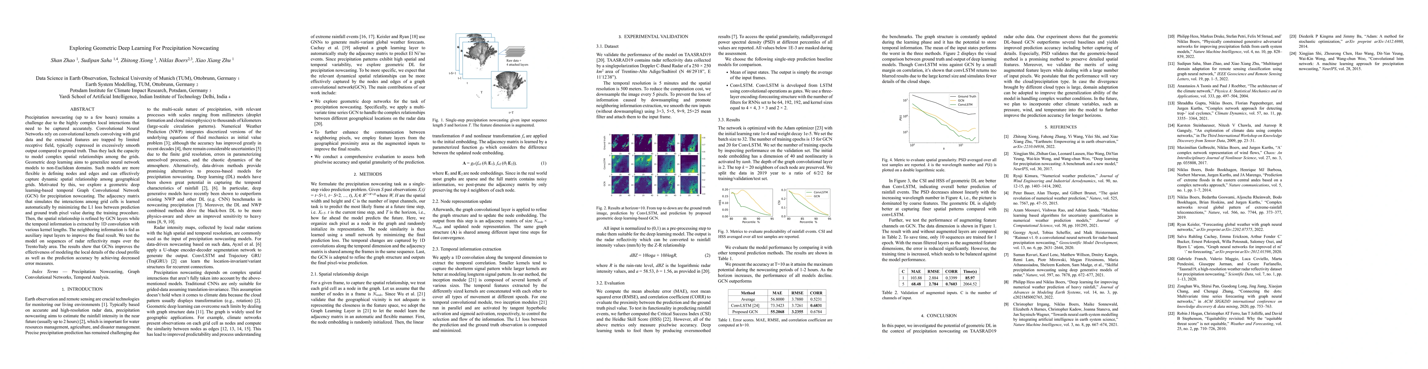
Precipitation nowcasting (up to a few hours) remains a challenge due to the highly complex local interactions that need to be captured accurately. Convolutional Neural Networks rely on convolutional...
Image classification is often prone to labelling uncertainty. To generate suitable training data, images are labelled according to evaluations of human experts. This can result in ambiguities, which...
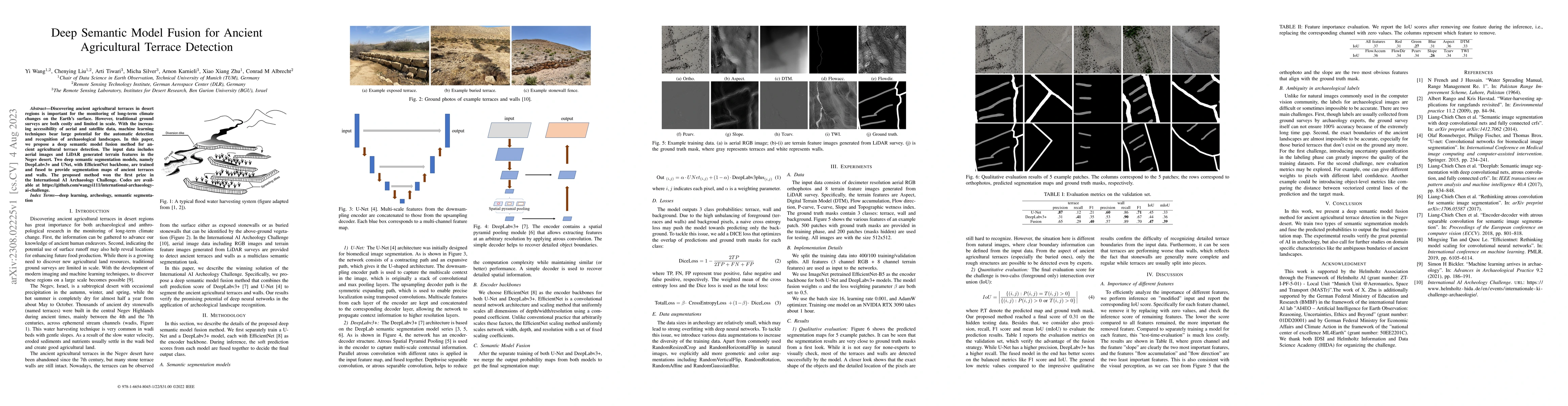
Discovering ancient agricultural terraces in desert regions is important for the monitoring of long-term climate changes on the Earth's surface. However, traditional ground surveys are both costly a...
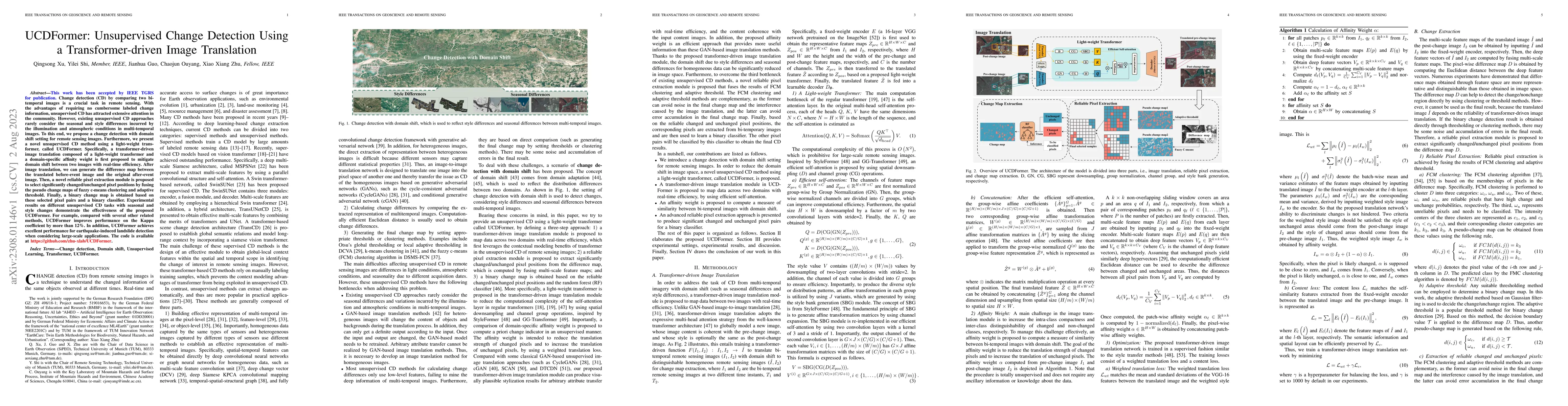
Change detection (CD) by comparing two bi-temporal images is a crucial task in remote sensing. With the advantages of requiring no cumbersome labeled change information, unsupervised CD has attracte...
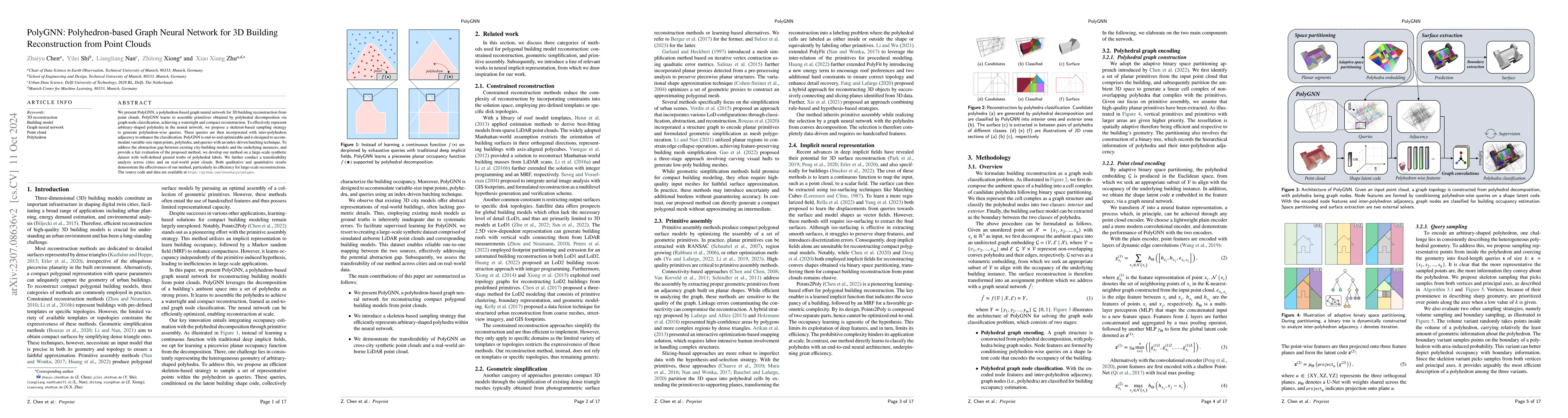
We present PolyGNN, a polyhedron-based graph neural network for 3D building reconstruction from point clouds. PolyGNN learns to assemble primitives obtained by polyhedral decomposition via graph nod...
Choosing how to encode a real-world problem as a machine learning task is an important design decision in machine learning. The task of glacier calving front modeling has often been approached as a ...
Hyperspectral image (HSI) classification is gaining a lot of momentum in present time because of high inherent spectral information within the images. However, these images suffer from the problem o...
Disaster mapping is a critical task that often requires on-site experts and is time-consuming. To address this, a comprehensive framework is presented for fast and accurate recognition of disasters ...
Localizing desired objects from remote sensing images is of great use in practical applications. Referring image segmentation, which aims at segmenting out the objects to which a given expression re...
Recent progress in self-supervision has shown that pre-training large neural networks on vast amounts of unsupervised data can lead to substantial increases in generalization to downstream tasks. Su...
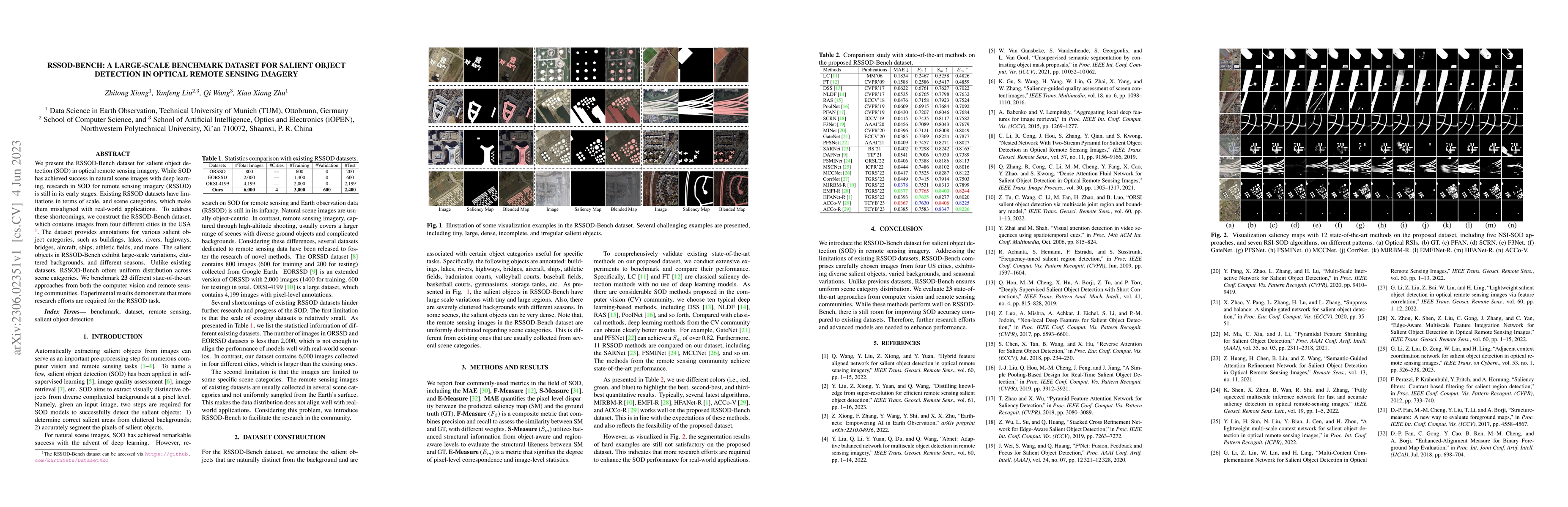
We present the RSSOD-Bench dataset for salient object detection (SOD) in optical remote sensing imagery. While SOD has achieved success in natural scene images with deep learning, research in SOD fo...
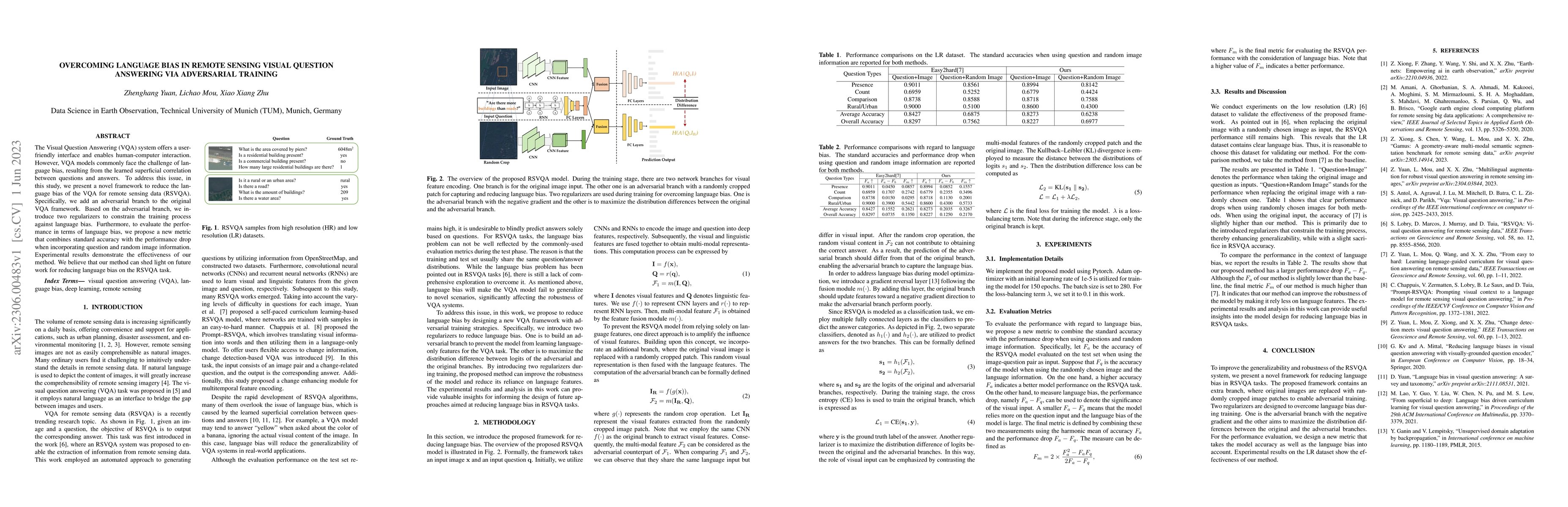
The Visual Question Answering (VQA) system offers a user-friendly interface and enables human-computer interaction. However, VQA models commonly face the challenge of language bias, resulting from t...
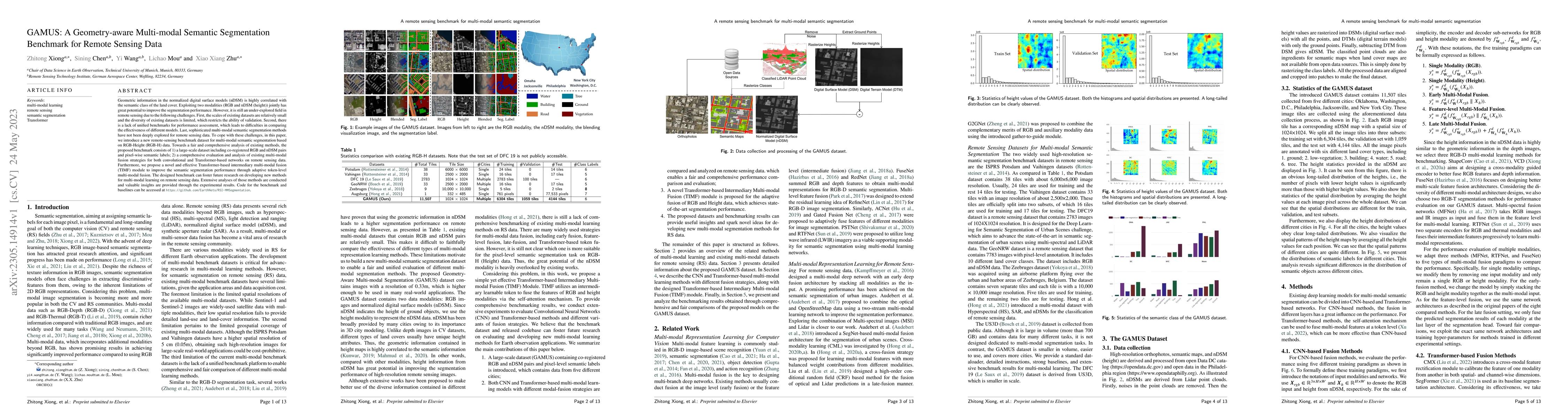
Geometric information in the normalized digital surface models (nDSM) is highly correlated with the semantic class of the land cover. Exploiting two modalities (RGB and nDSM (height)) jointly has gr...
Finding sparse solutions of underdetermined linear systems commonly requires the solving of L1 regularized least squares minimization problem, which is also known as the basis pursuit denoising (BPD...
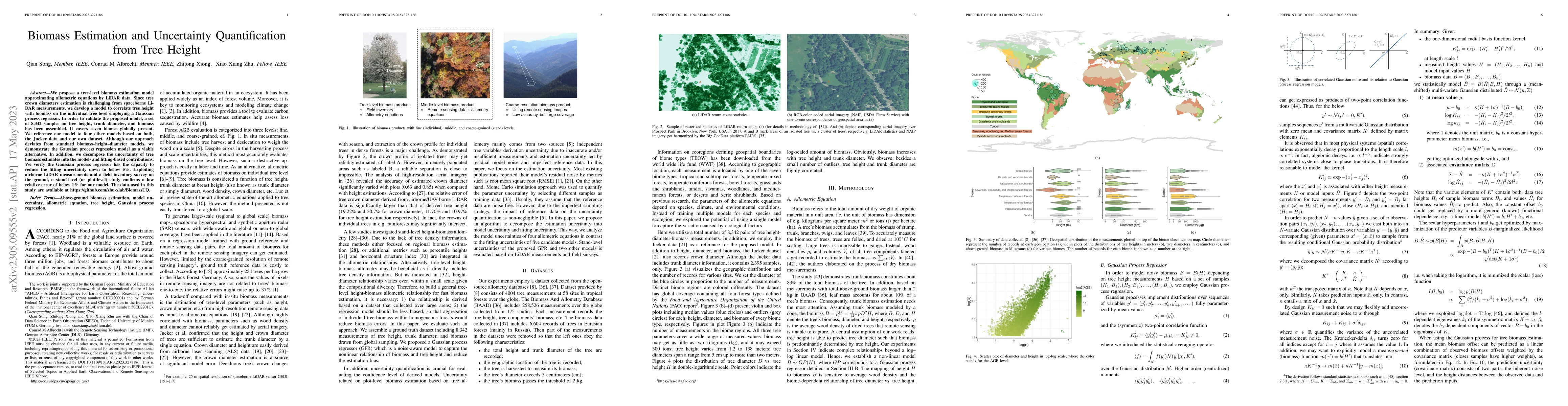
We propose a tree-level biomass estimation model approximating allometric equations by LiDAR data. Since tree crown diameters estimation is challenging from spaceborne LiDAR measurements, we develop...
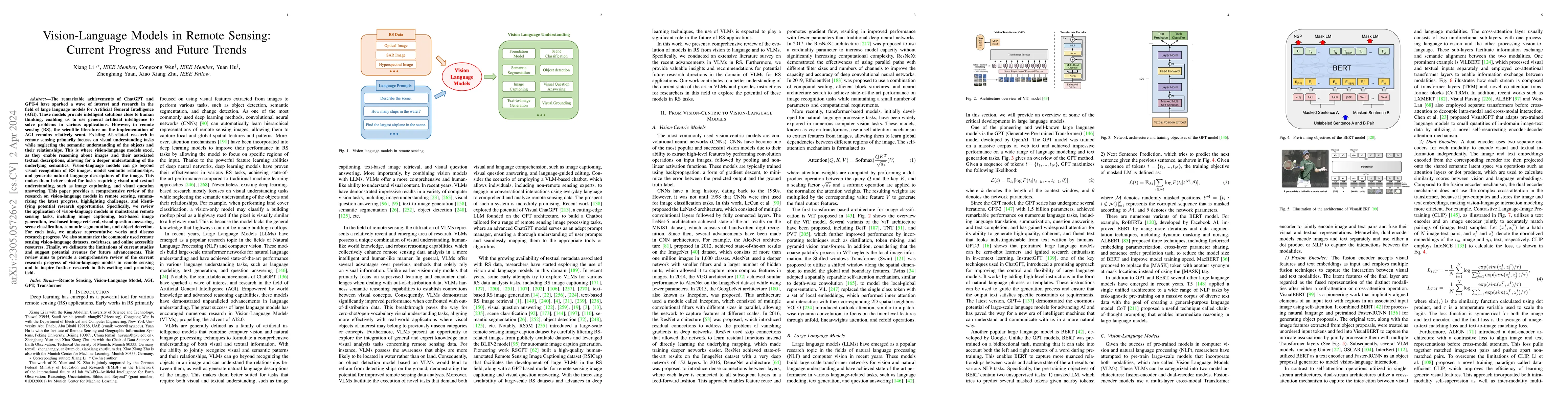
The remarkable achievements of ChatGPT and GPT-4 have sparked a wave of interest and research in the field of large language models for Artificial General Intelligence (AGI). These models provide in...
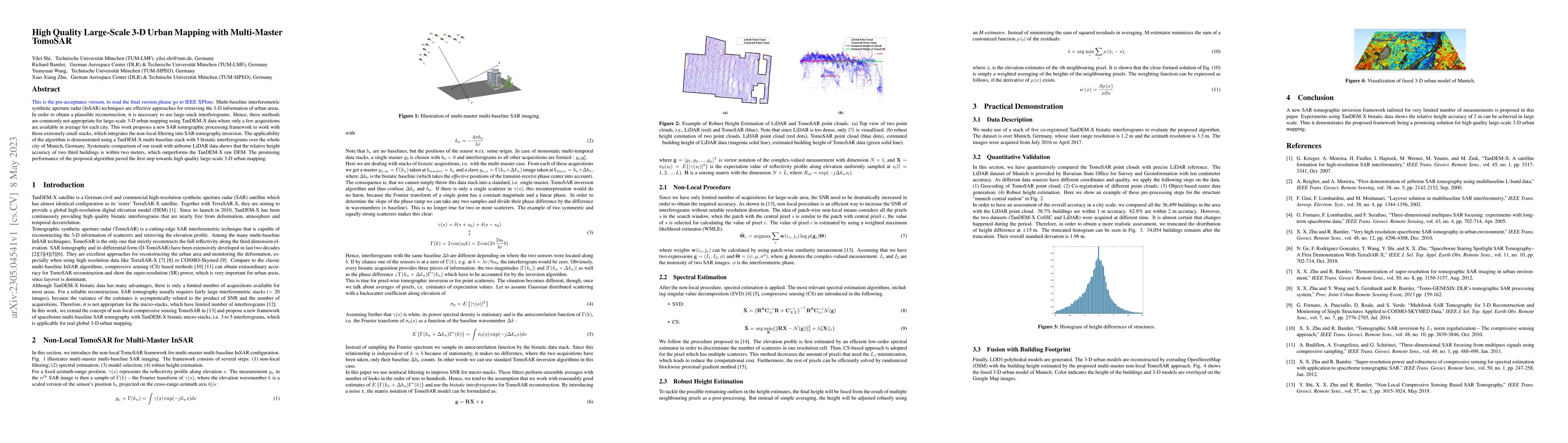
Multi-baseline interferometric synthetic aperture radar (InSAR) techniques are effective approaches for retrieving the 3-D information of urban areas. In order to obtain a plausible reconstruction, ...
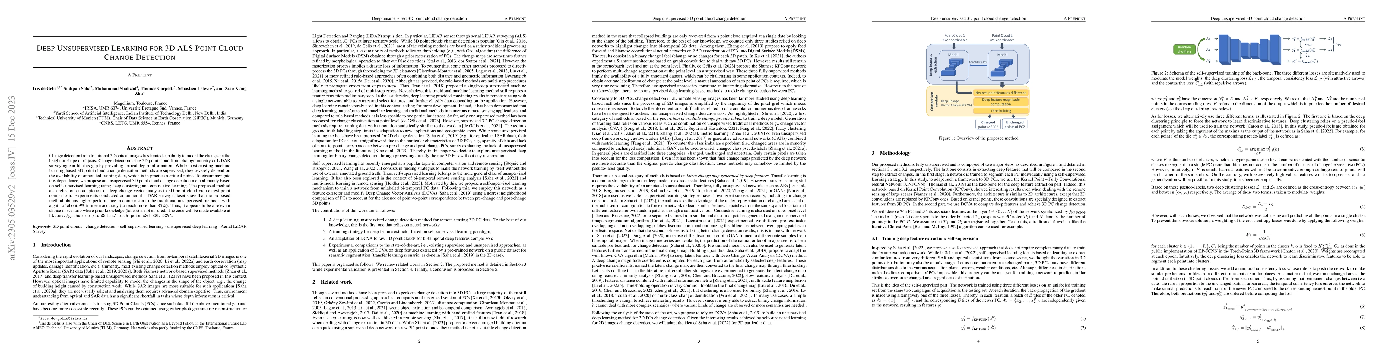
Change detection from traditional \added{2D} optical images has limited capability to model the changes in the height or shape of objects. Change detection using 3D point cloud \added{from photogram...
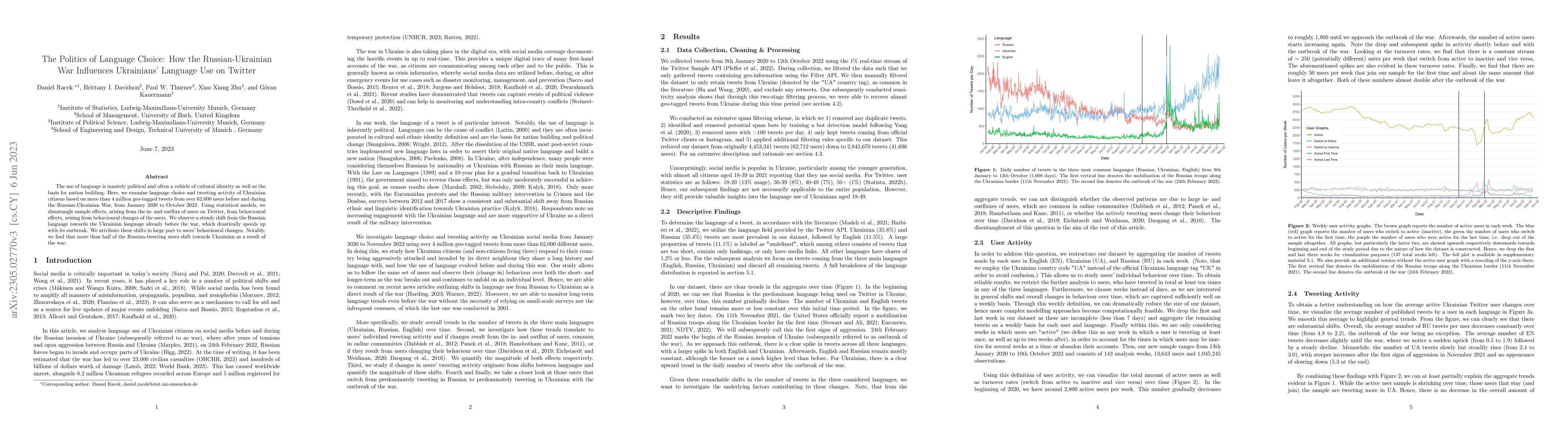
The use of language is innately political and often a vehicle of cultural identity as well as the basis for nation building. Here, we examine language choice and tweeting activity of Ukrainian citiz...
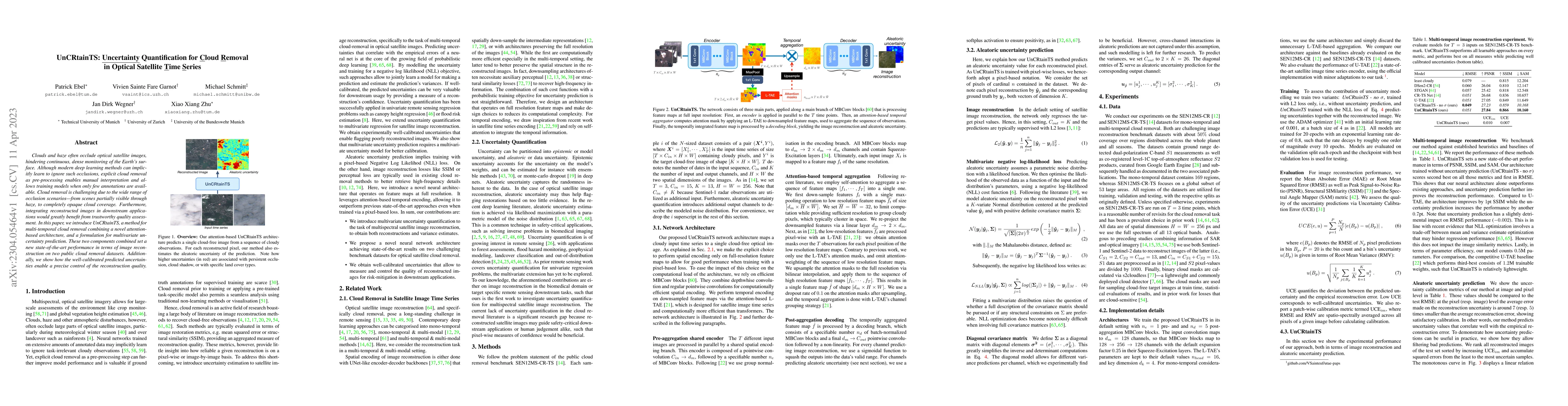
Clouds and haze often occlude optical satellite images, hindering continuous, dense monitoring of the Earth's surface. Although modern deep learning methods can implicitly learn to ignore such occlu...

Aiming at answering questions based on the content of remotely sensed images, visual question answering for remote sensing data (RSVQA) has attracted much attention nowadays. However, previous works...
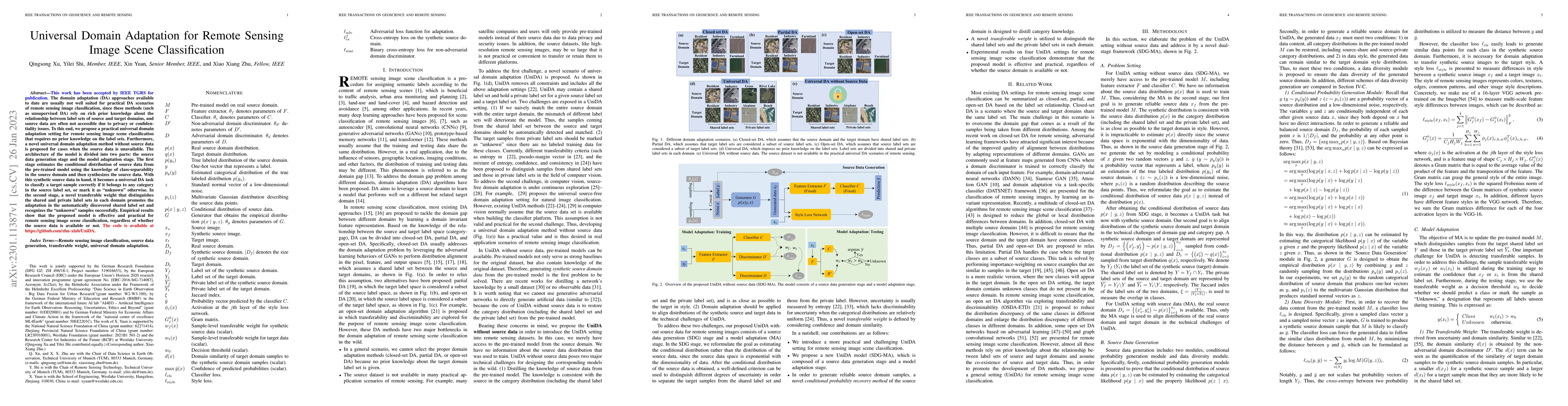
The domain adaptation (DA) approaches available to date are usually not well suited for practical DA scenarios of remote sensing image classification, since these methods (such as unsupervised DA) r...
Self-supervised pre-training bears potential to generate expressive representations without human annotation. Most pre-training in Earth observation (EO) are based on ImageNet or medium-size, labele...
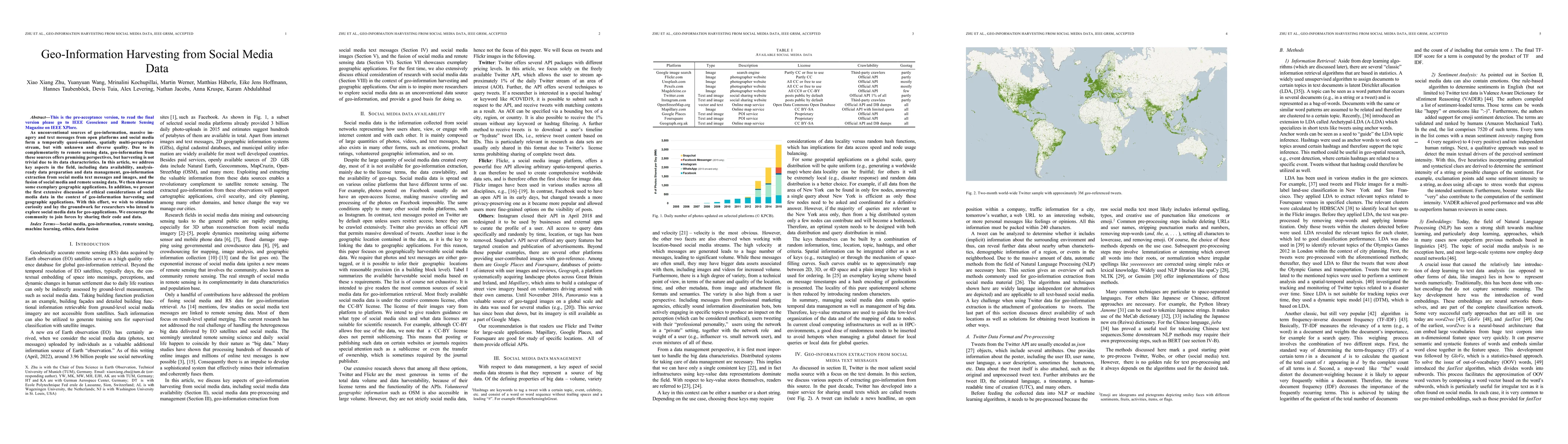
As unconventional sources of geo-information, massive imagery and text messages from open platforms and social media form a temporally quasi-seamless, spatially multi-perspective stream, but with un...
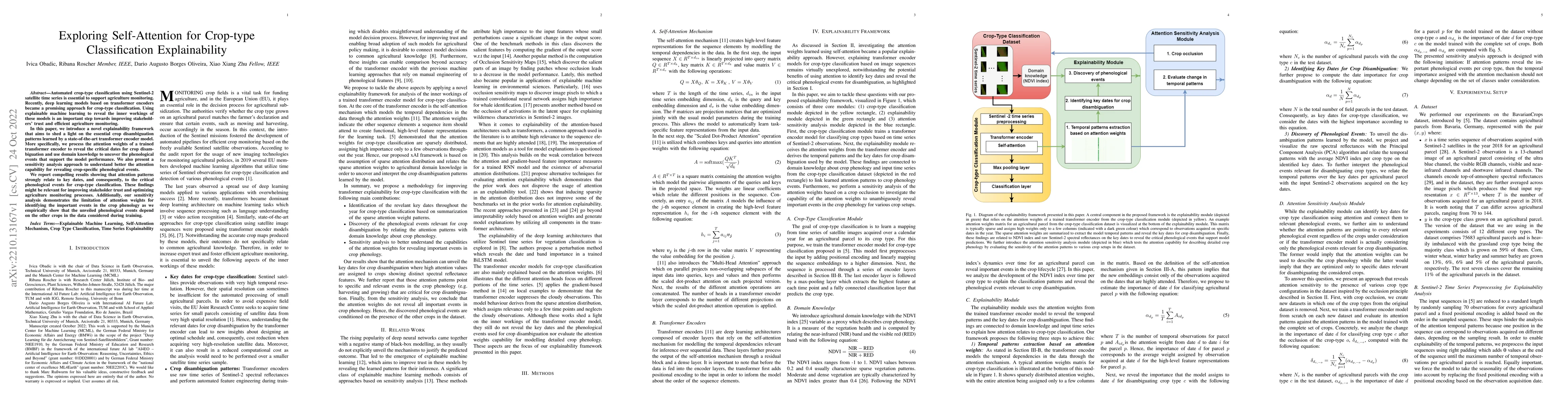
Automated crop-type classification using Sentinel-2 satellite time series is essential to support agriculture monitoring. Recently, deep learning models based on transformer encoders became a promis...
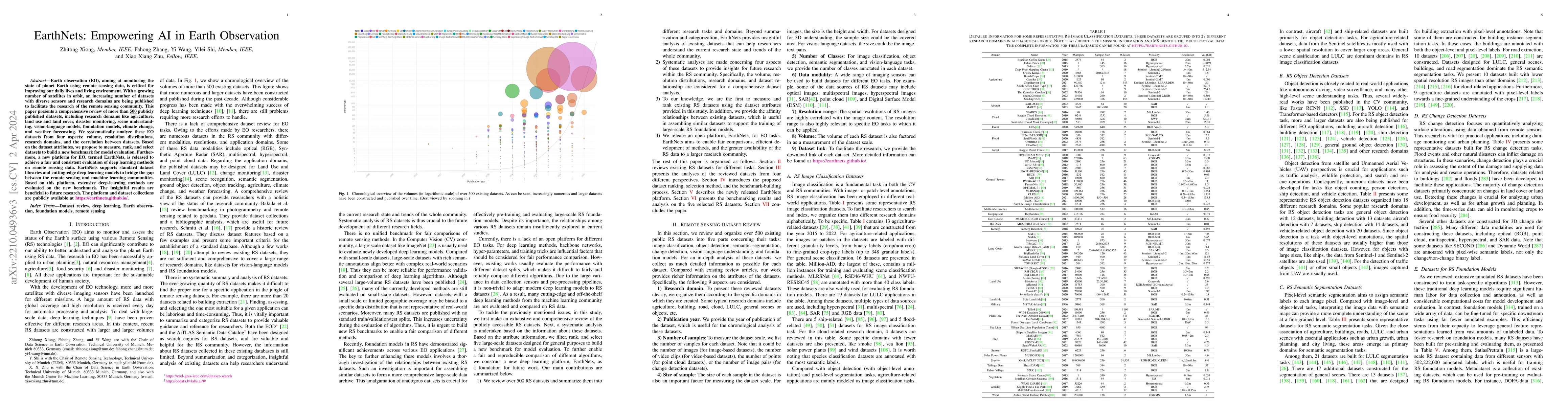
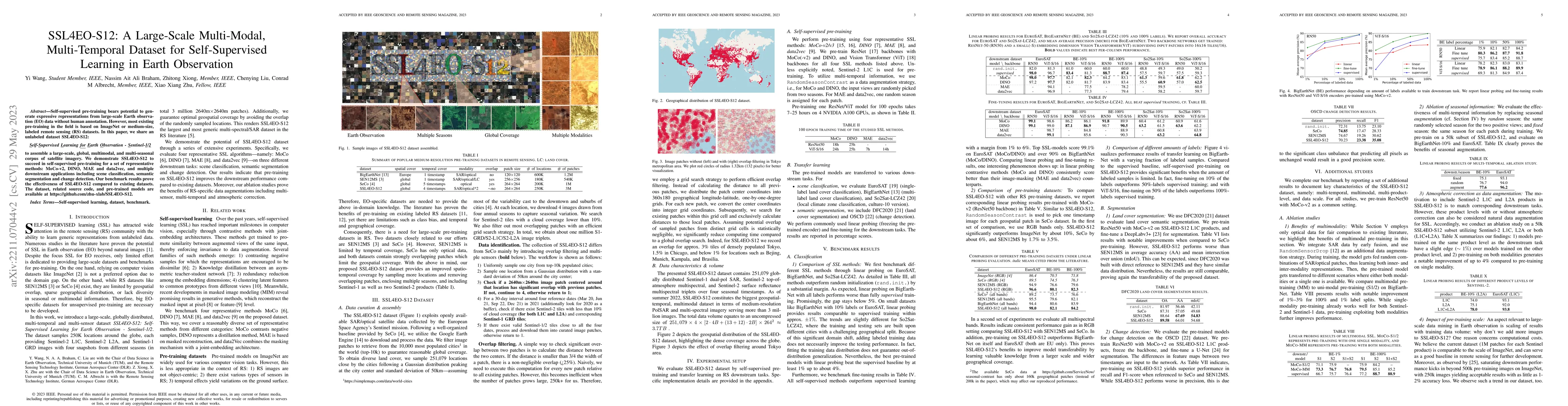
Earth observation (EO), aiming at monitoring the state of planet Earth using remote sensing data, is critical for improving our daily lives and living environment. With a growing number of satellite...
Unmanned aerial vehicles (UAVs) are widely applied for purposes of inspection, search, and rescue operations by the virtue of low-cost, large-coverage, real-time, and high-resolution data acquisitio...
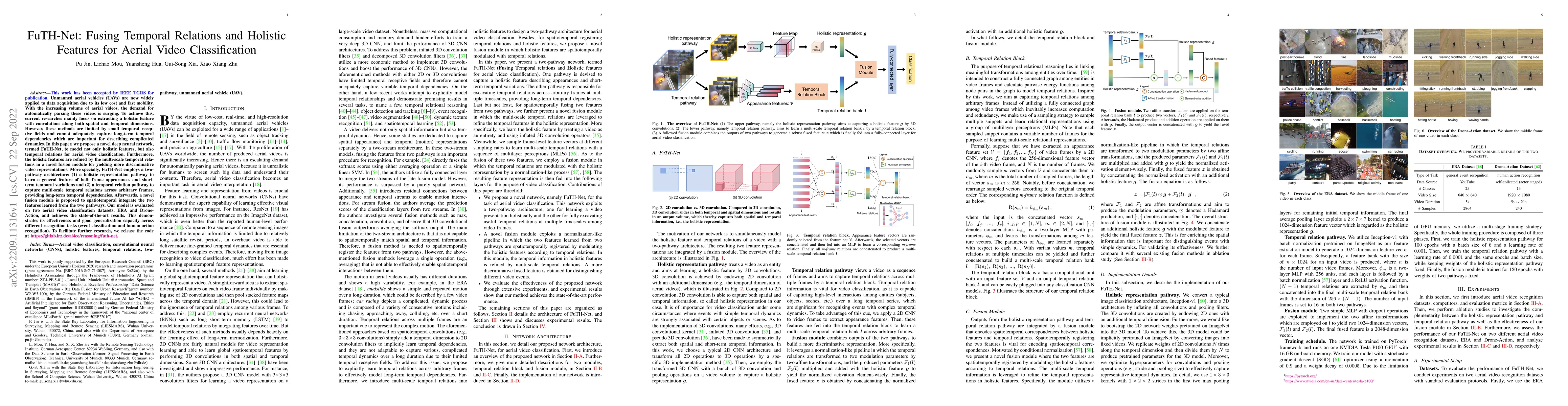
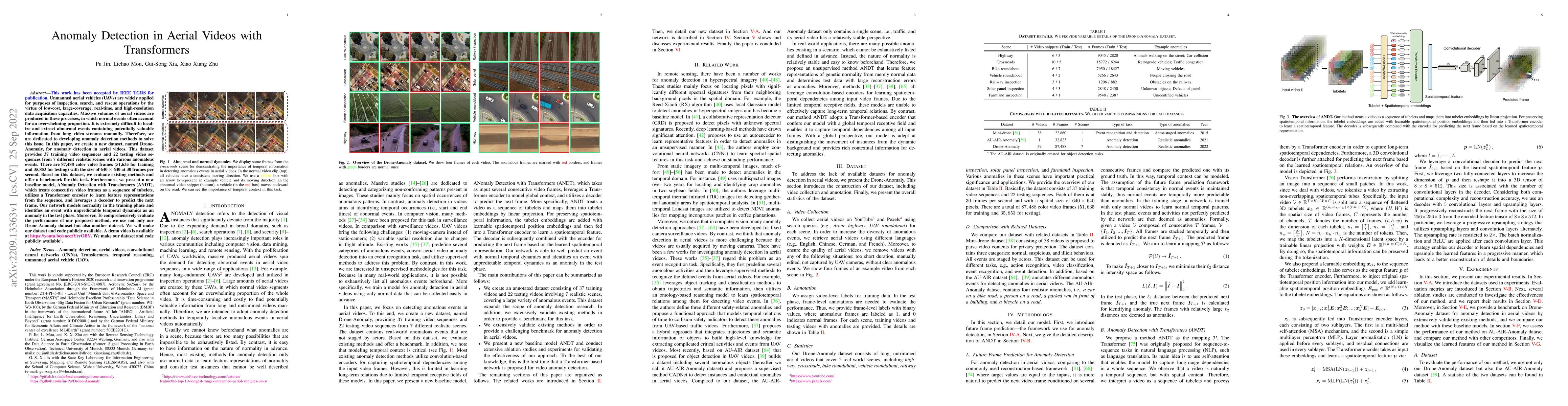
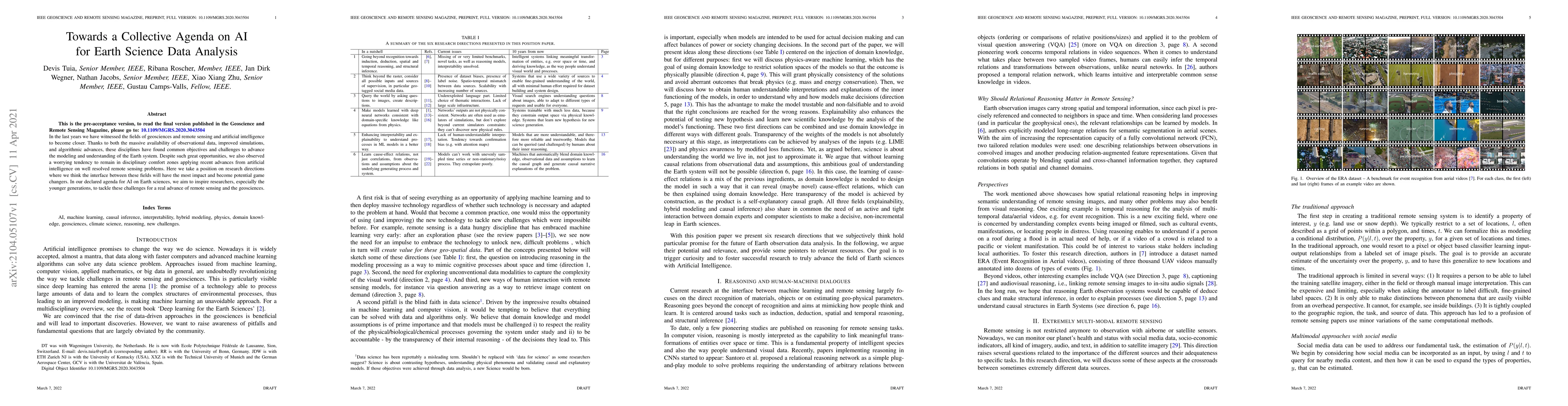
Unmanned aerial vehicles (UAVs) are now widely applied to data acquisition due to its low cost and fast mobility. With the increasing volume of aerial videos, the demand for automatically parsing th...
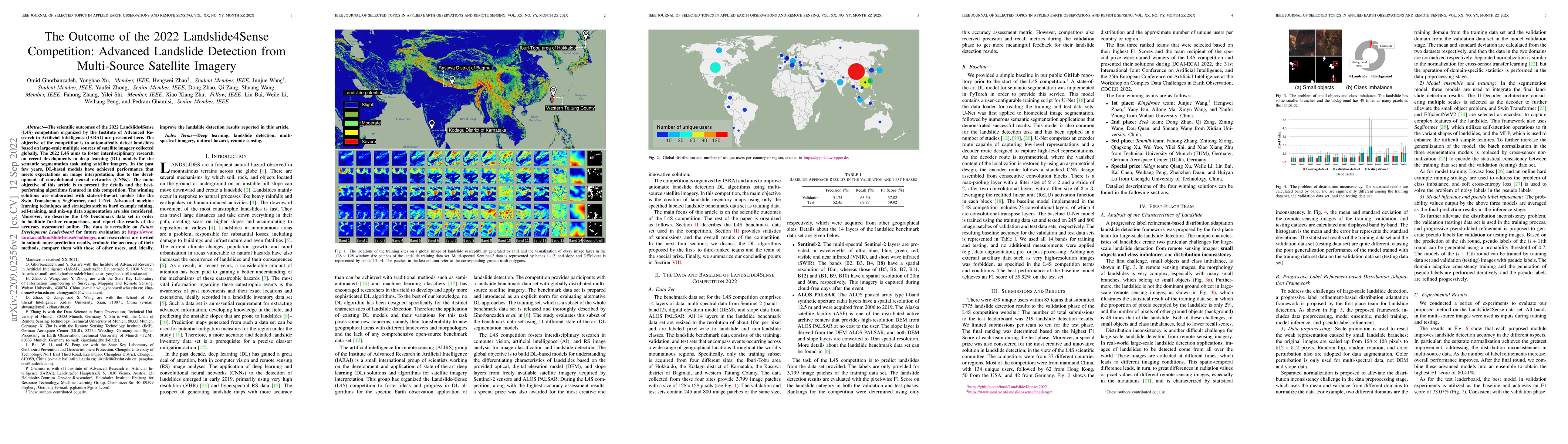
The scientific outcomes of the 2022 Landslide4Sense (L4S) competition organized by the Institute of Advanced Research in Artificial Intelligence (IARAI) are presented here. The objective of the comp...
High-resolution satellite images can provide abundant, detailed spatial information for land cover classification, which is particularly important for studying the complicated built environment. How...
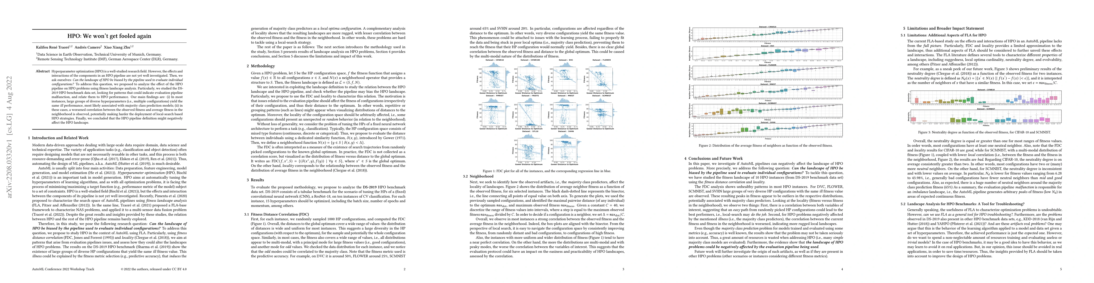
Hyperparameter optimization (HPO) is a well-studied research field. However, the effects and interactions of the components in an HPO pipeline are not yet well investigated. Then, we ask ourselves: ...
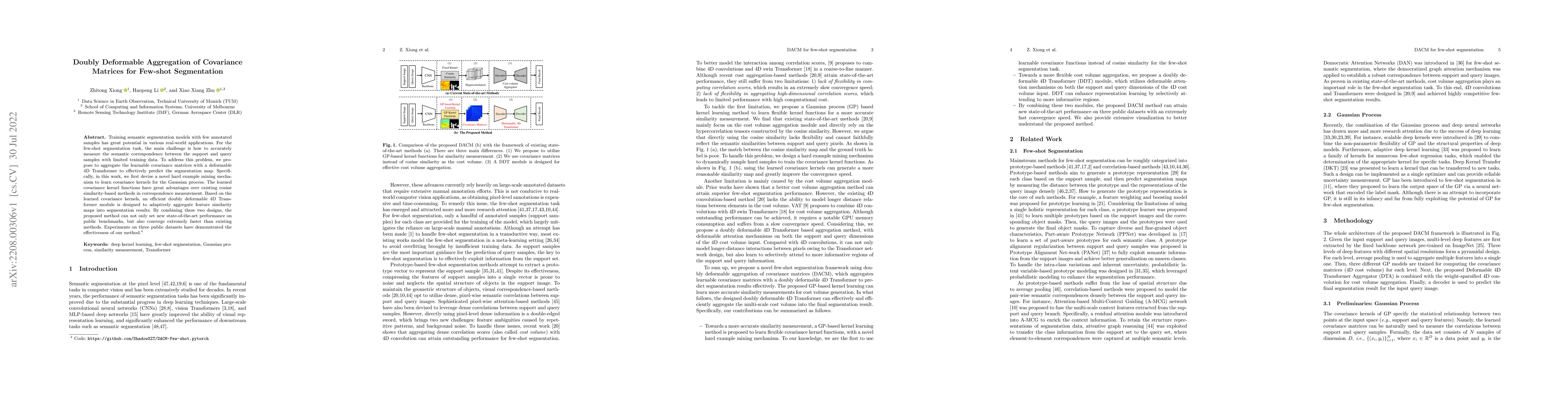
Training semantic segmentation models with few annotated samples has great potential in various real-world applications. For the few-shot segmentation task, the main challenge is how to accurately m...
In deep learning research, self-supervised learning (SSL) has received great attention triggering interest within both the computer vision and remote sensing communities. While there has been a big ...
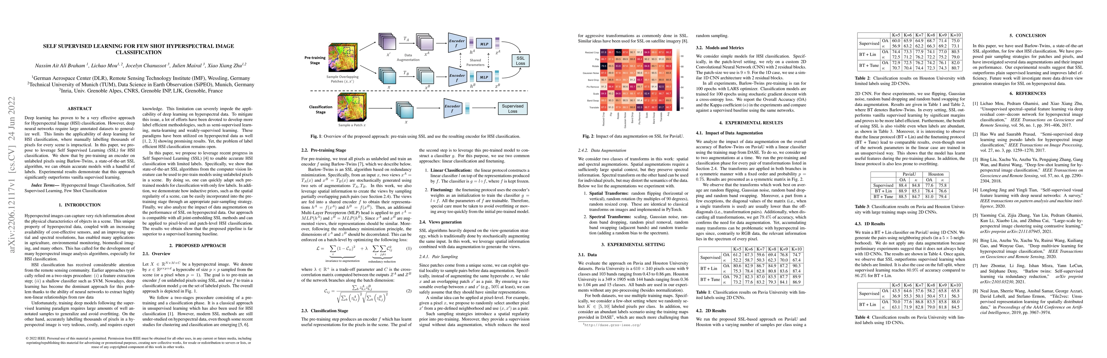
Deep learning has proven to be a very effective approach for Hyperspectral Image (HSI) classification. However, deep neural networks require large annotated datasets to generalize well. This limits ...
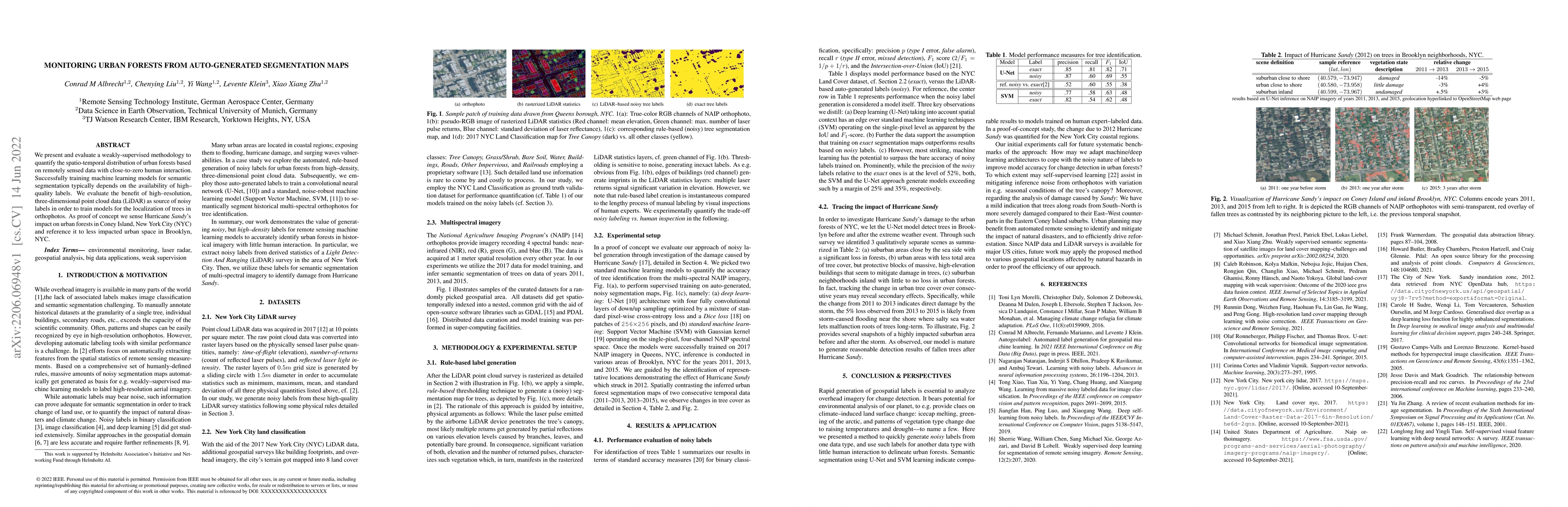
We present and evaluate a weakly-supervised methodology to quantify the spatio-temporal distribution of urban forests based on remotely sensed data with close-to-zero human interaction. Successfully...
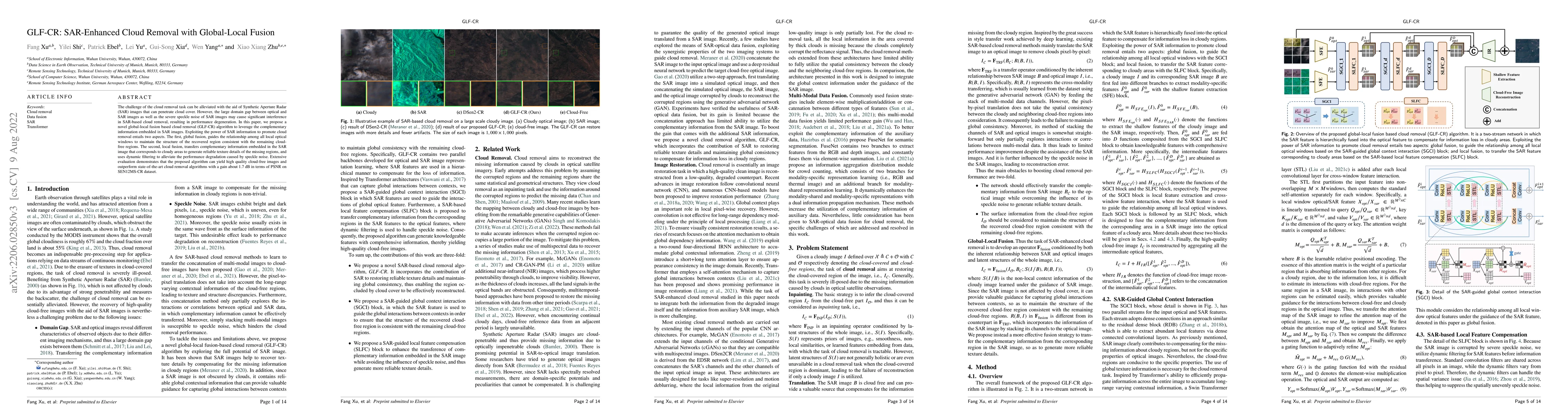
The challenge of the cloud removal task can be alleviated with the aid of Synthetic Aperture Radar (SAR) images that can penetrate cloud cover. However, the large domain gap between optical and SAR ...
Technological and computational advances continuously drive forward the broad field of deep learning. In recent years, the derivation of quantities describing theuncertainty in the prediction - whic...
Accurate and reliable building footprint maps are vital to urban planning and monitoring, and most existing approaches fall back on convolutional neural networks (CNNs) for building footprint genera...
Visual question answering (VQA) for remote sensing scene has great potential in intelligent human-computer interaction system. Although VQA in computer vision has been widely researched, VQA for rem...
Obtaining a dynamic population distribution is key to many decision-making processes such as urban planning, disaster management and most importantly helping the government to better allocate socio-...
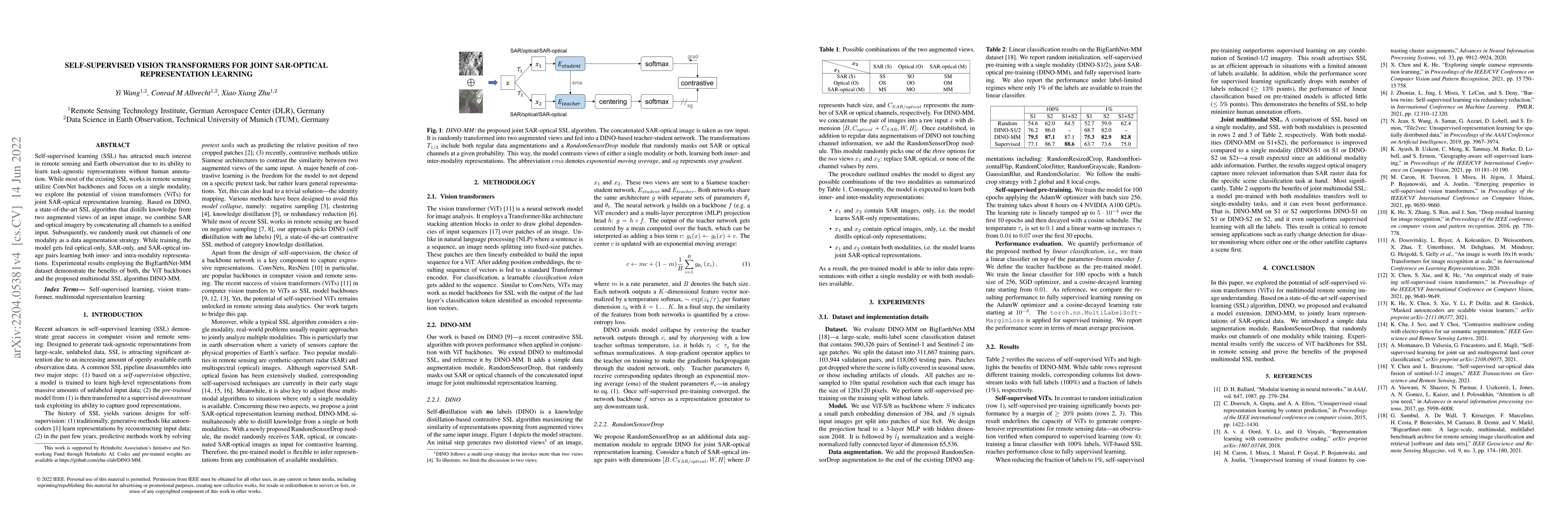
Self-supervised learning (SSL) has attracted much interest in remote sensing and earth observation due to its ability to learn task-agnostic representations without human annotation. While most of t...
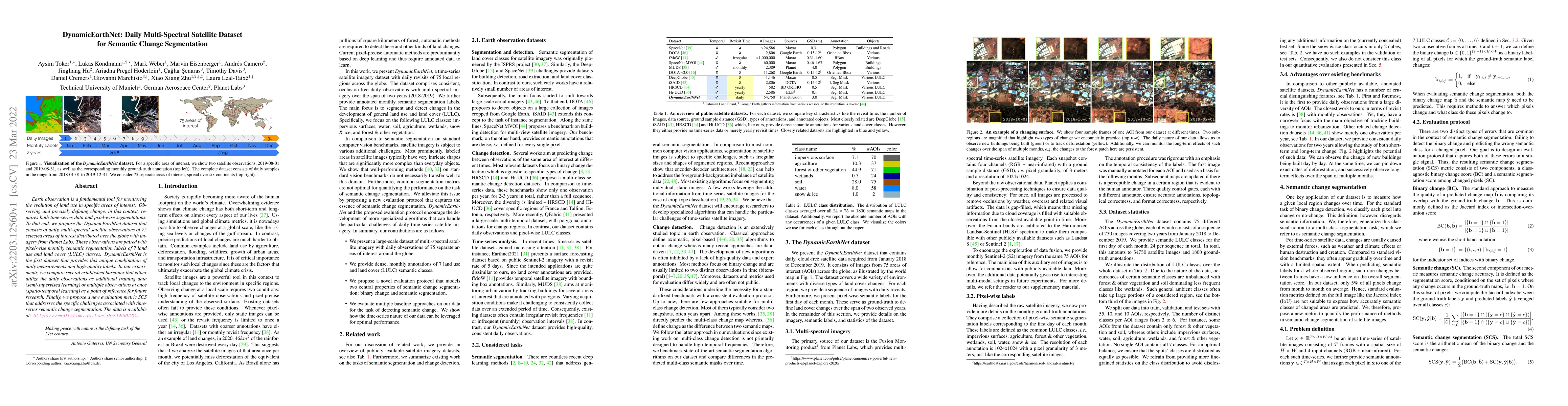
Earth observation is a fundamental tool for monitoring the evolution of land use in specific areas of interest. Observing and precisely defining change, in this context, requires both time-series da...
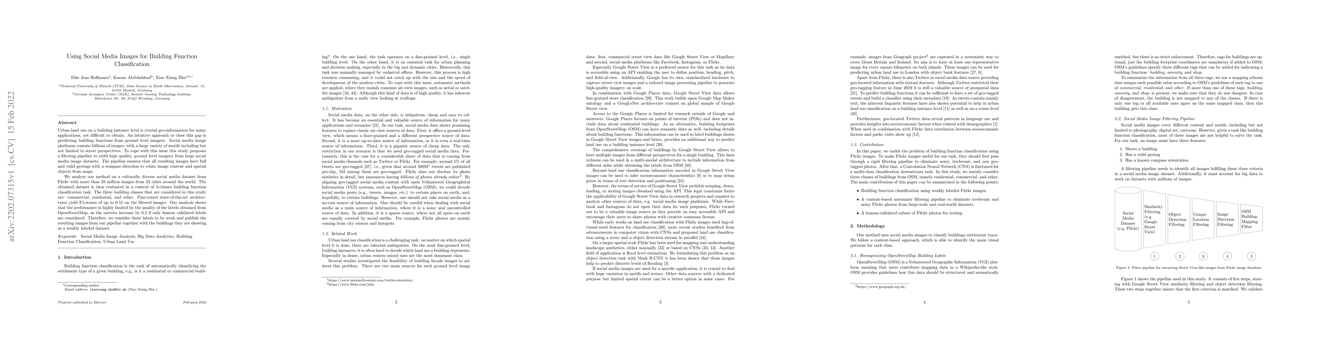
Urban land use on a building instance level is crucial geo-information for many applications, yet difficult to obtain. An intuitive approach to close this gap is predicting building functions from g...
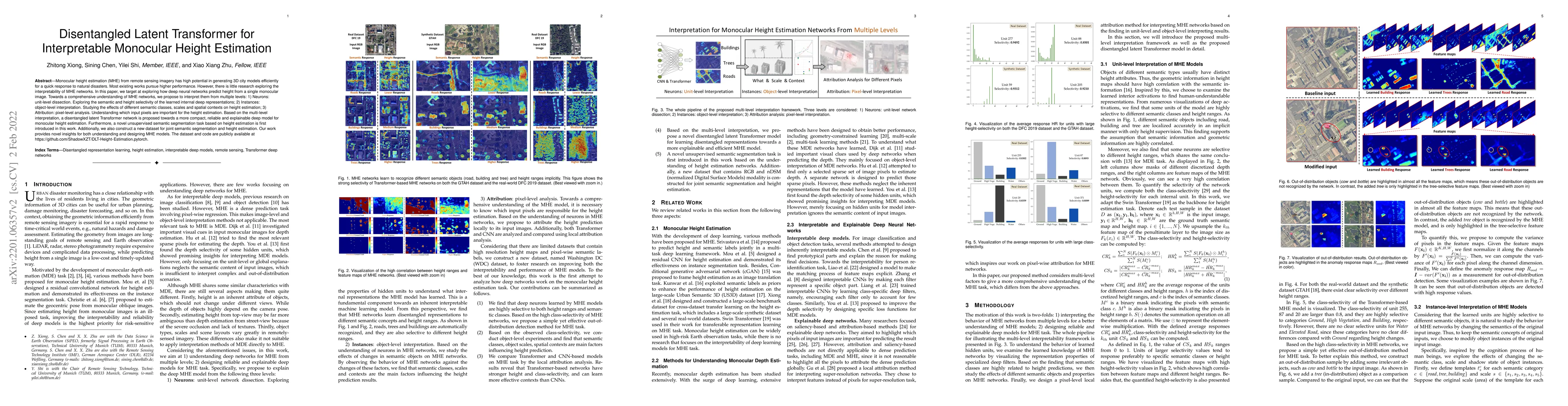
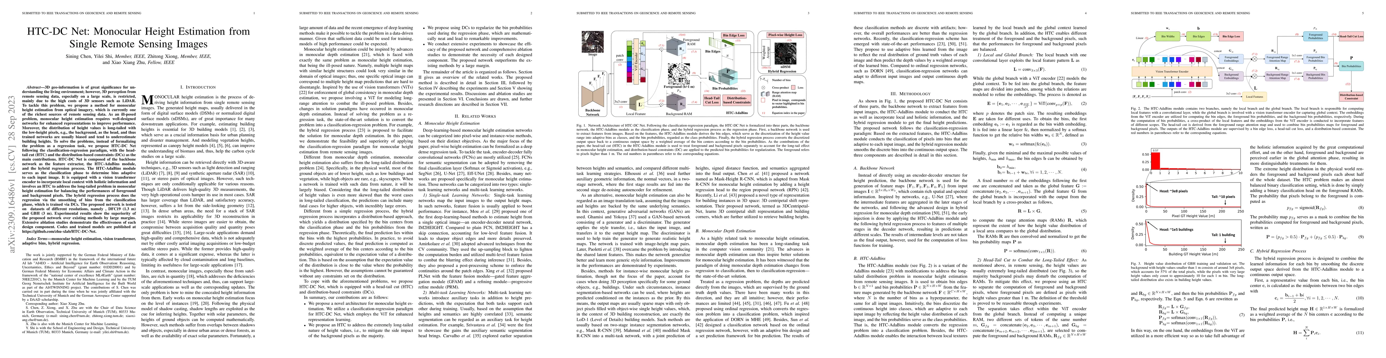
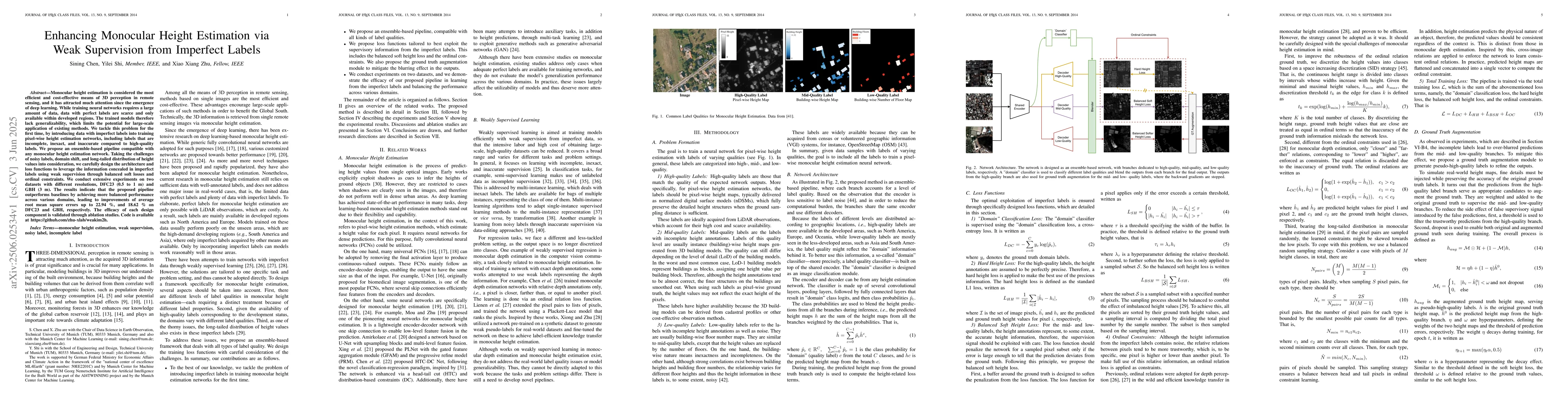
Monocular height estimation (MHE) from remote sensing imagery has high potential in generating 3D city models efficiently for a quick response to natural disasters. Most existing works pursue higher...
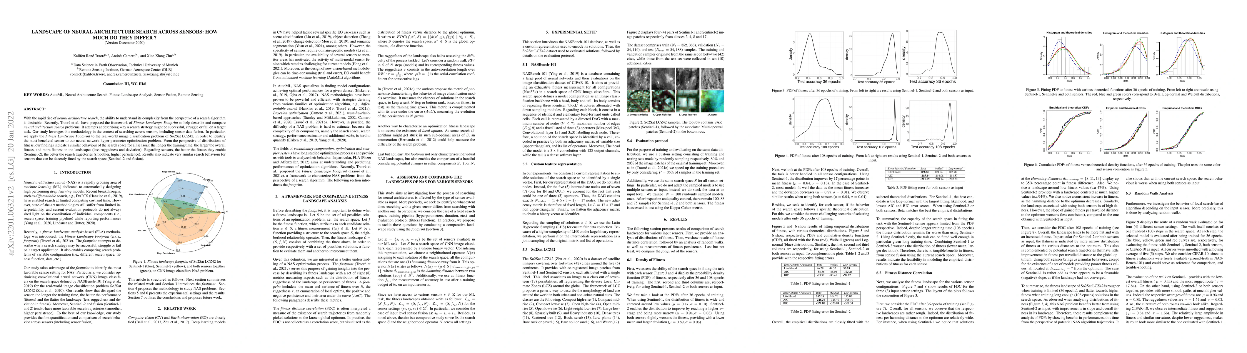
With the rapid rise of neural architecture search, the ability to understand its complexity from the perspective of a search algorithm is desirable. Recently, Traor\'e et al. have proposed the frame...
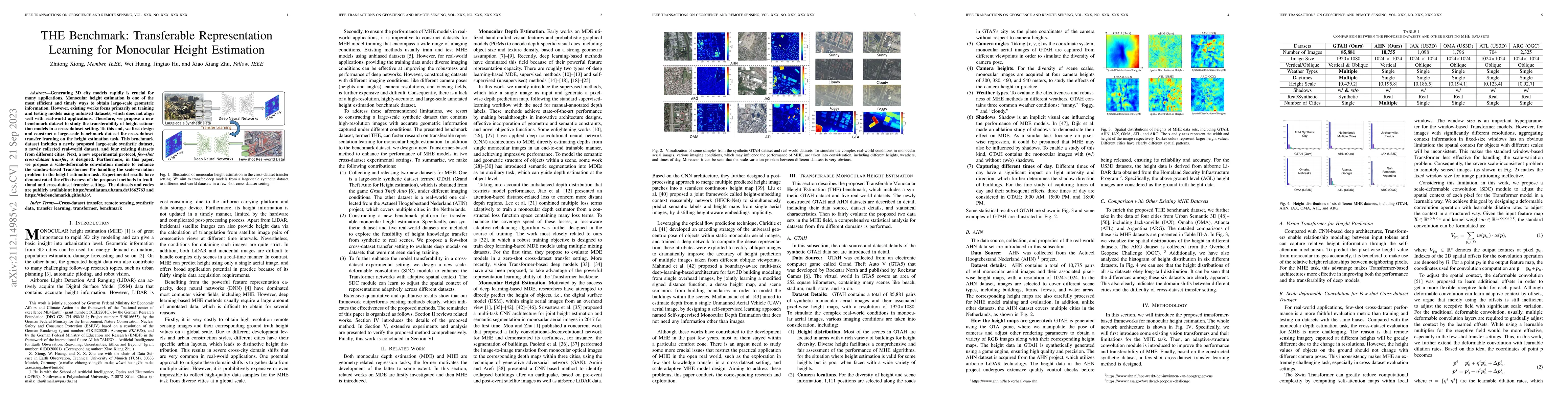
Generating 3D city models rapidly is crucial for many applications. Monocular height estimation is one of the most efficient and timely ways to obtain large-scale geometric information. However, exi...
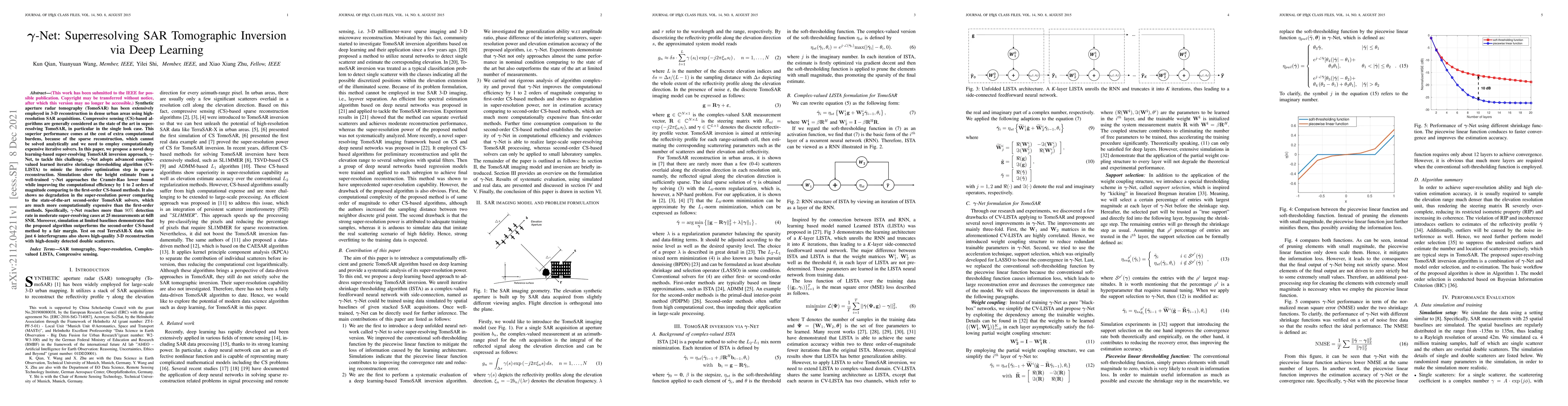
Synthetic aperture radar tomography (TomoSAR) has been extensively employed in 3-D reconstruction in dense urban areas using high-resolution SAR acquisitions. Compressive sensing (CS)-based algorith...
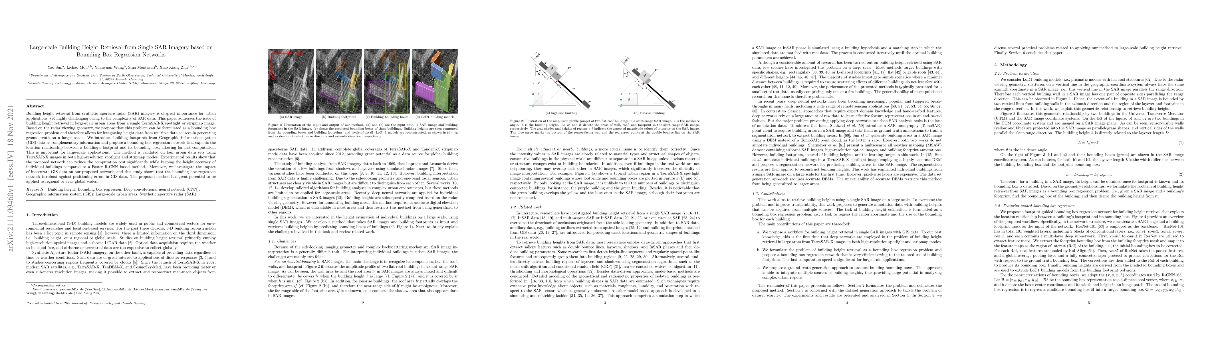
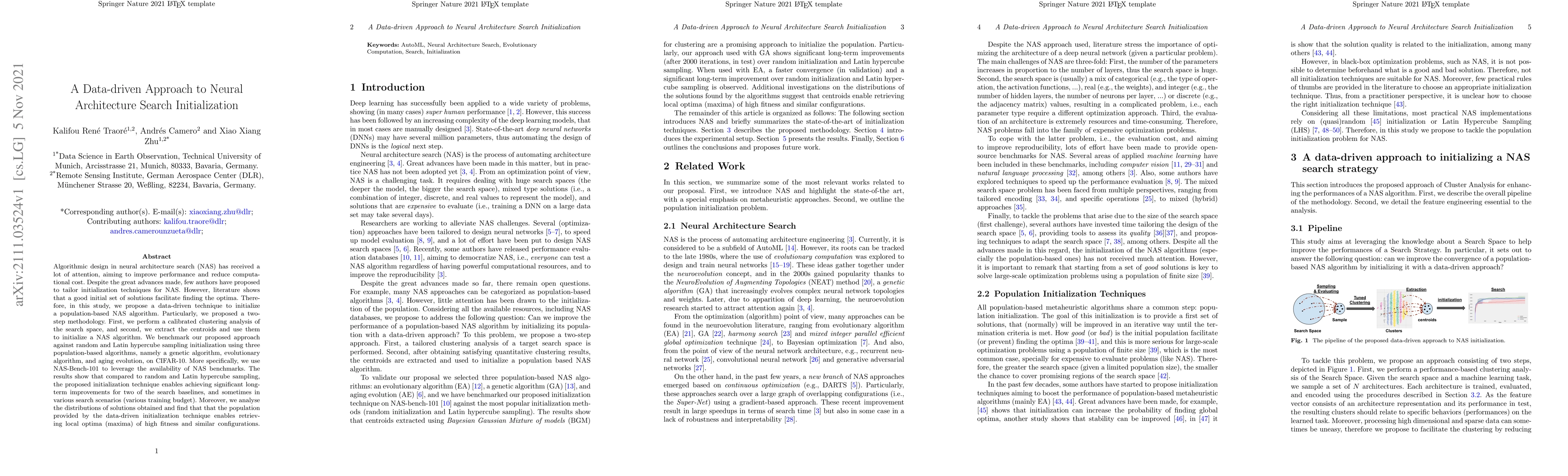
Building height retrieval from synthetic aperture radar (SAR) imagery is of great importance for urban applications, yet highly challenging owing to the complexity of SAR data. This paper addresses ...
Algorithmic design in neural architecture search (NAS) has received a lot of attention, aiming to improve performance and reduce computational cost. Despite the great advances made, few authors have...
Neural architecture search is a promising area of research dedicated to automating the design of neural network models. This field is rapidly growing, with a surge of methodologies ranging from Baye...
Although Convolution Neural Networks (CNNs) has made substantial progress in the low-light image enhancement task, one critical problem of CNNs is the paradox of model complexity and performance. Th...
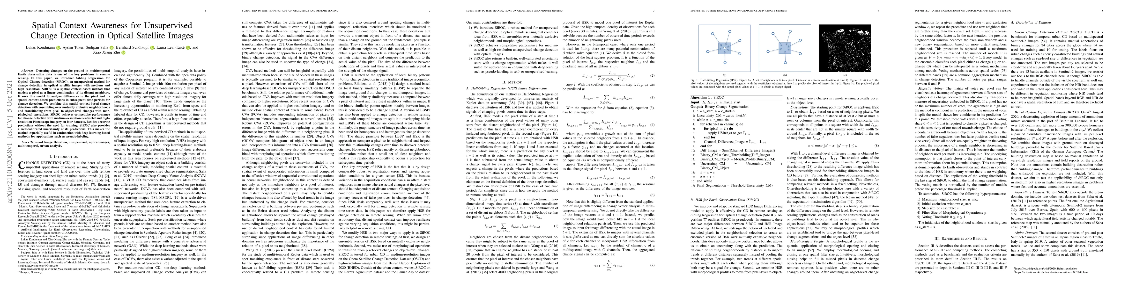
Detecting changes on the ground in multitemporal Earth observation data is one of the key problems in remote sensing. In this paper, we introduce Sibling Regression for Optical Change detection (SiR...
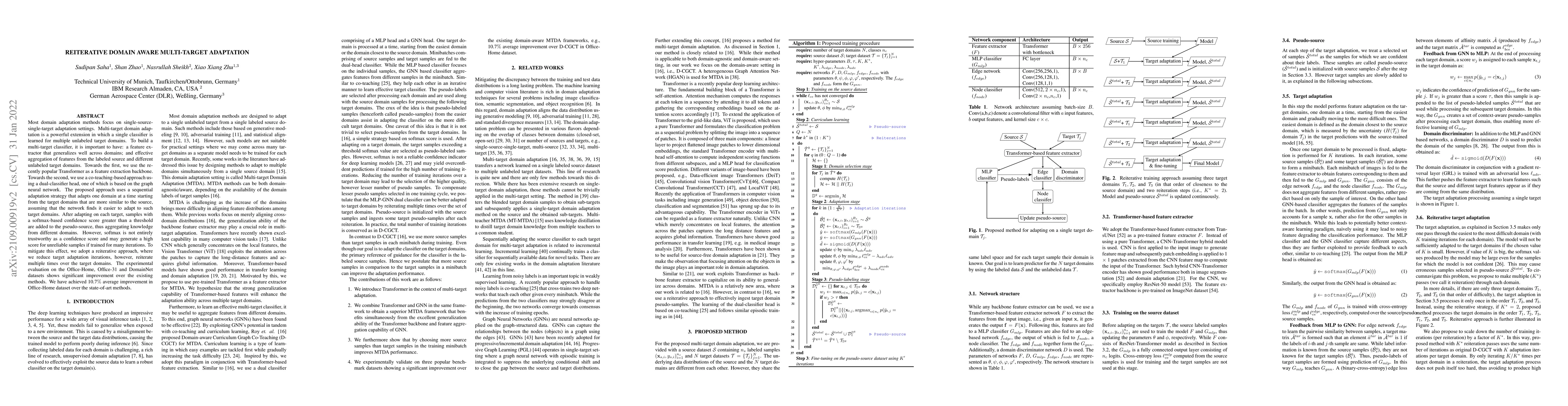
Most domain adaptation methods focus on single-source-single-target adaptation settings. Multi-target domain adaptation is a powerful extension in which a single classifier is learned for multiple u...
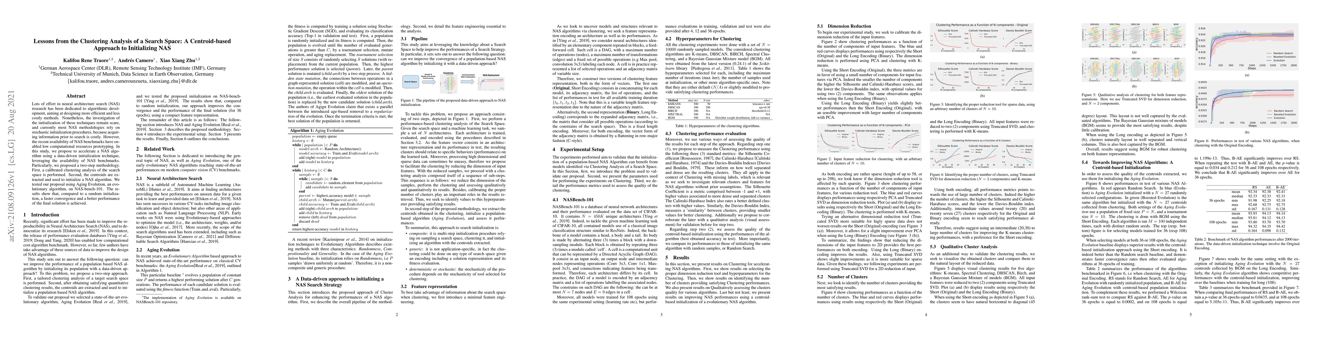
Lots of effort in neural architecture search (NAS) research has been dedicated to algorithmic development, aiming at designing more efficient and less costly methods. Nonetheless, the investigation ...
Semantic segmentation is a crucial step in many Earth observation tasks. Large quantity of pixel-level annotation is required to train deep networks for semantic segmentation. Earth observation tech...
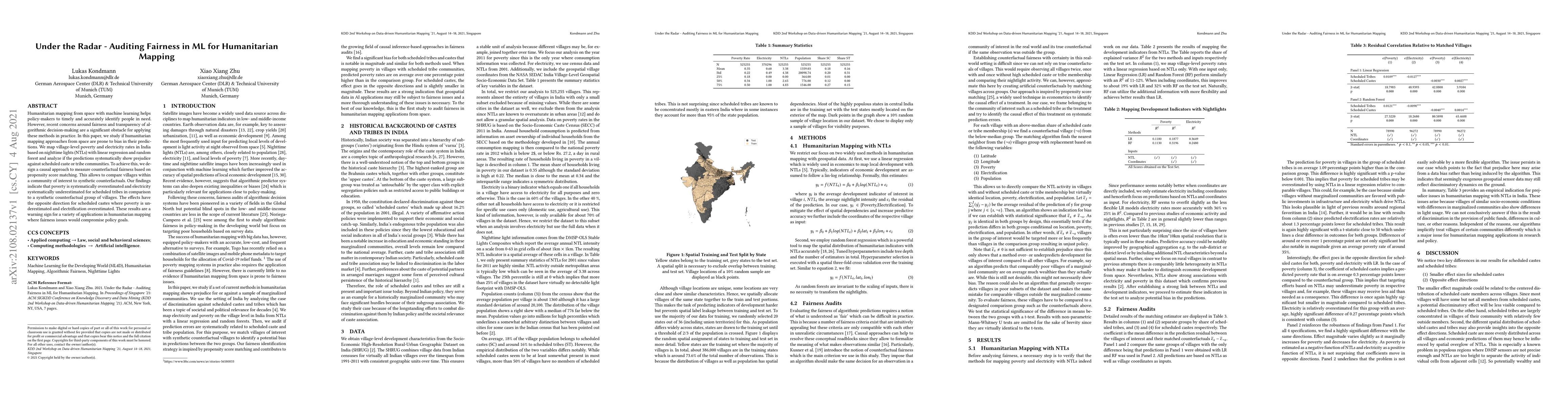
Humanitarian mapping from space with machine learning helps policy-makers to timely and accurately identify people in need. However, recent concerns around fairness and transparency of algorithmic d...
Due to their increasing spread, confidence in neural network predictions became more and more important. However, basic neural networks do not deliver certainty estimates or suffer from over or unde...
As remote sensing (RS) data obtained from different sensors become available largely and openly, multimodal data processing and analysis techniques have been garnering increasing interest in the RS ...
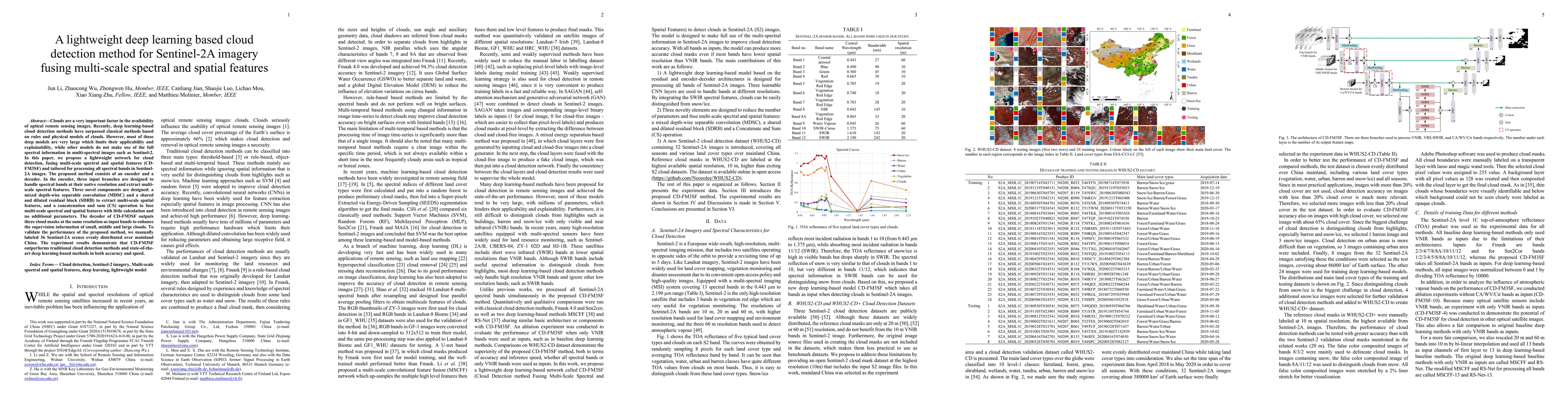
Clouds are a very important factor in the availability of optical remote sensing images. Recently, deep learning-based cloud detection methods have surpassed classical methods based on rules and phy...
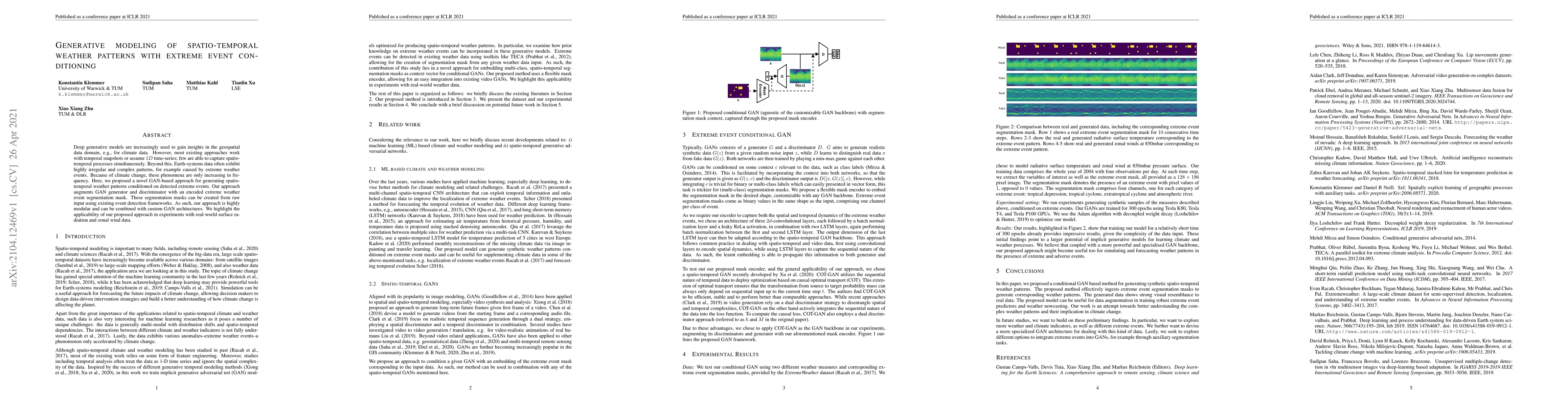
Deep generative models are increasingly used to gain insights in the geospatial data domain, e.g., for climate data. However, most existing approaches work with temporal snapshots or assume 1D time-...
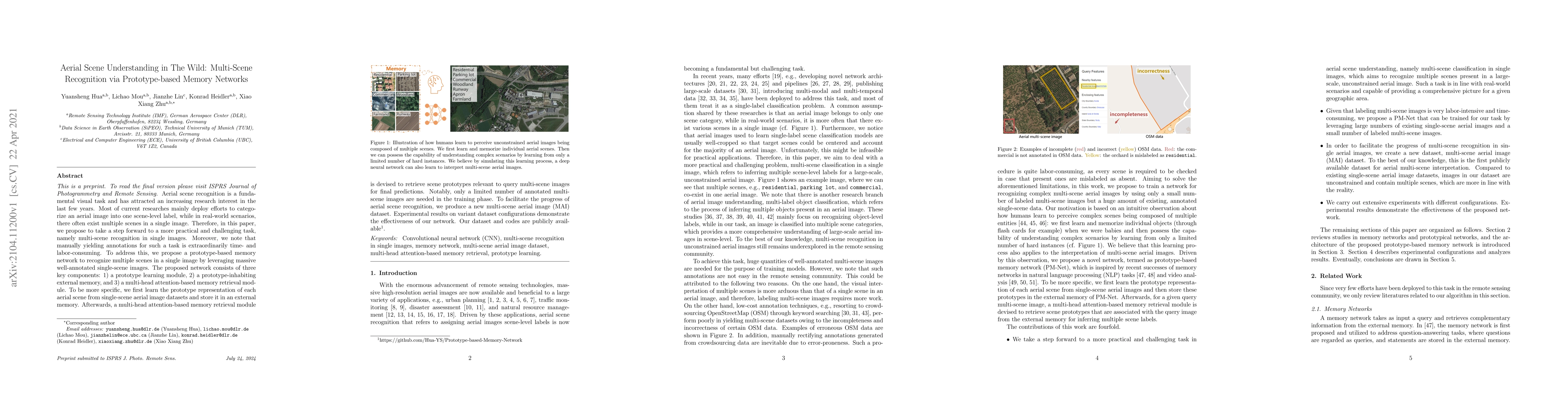
Aerial scene recognition is a fundamental visual task and has attracted an increasing research interest in the last few years. Most of current researches mainly deploy efforts to categorize an aeria...
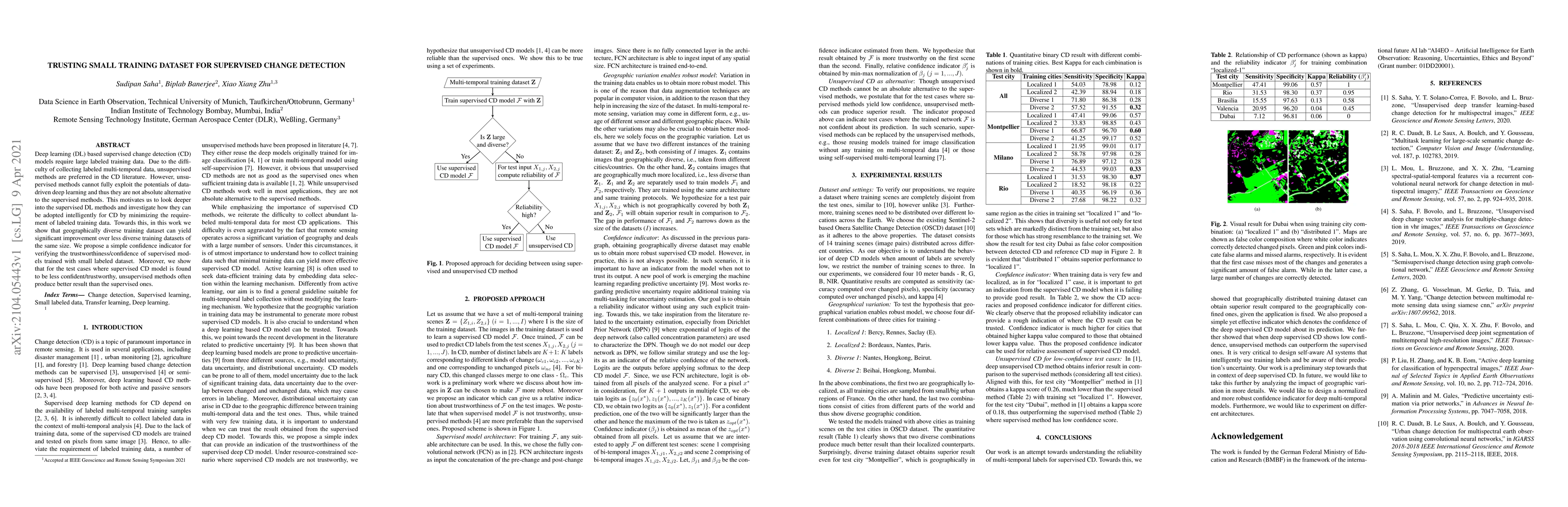
Deep learning (DL) based supervised change detection (CD) models require large labeled training data. Due to the difficulty of collecting labeled multi-temporal data, unsupervised methods are prefer...
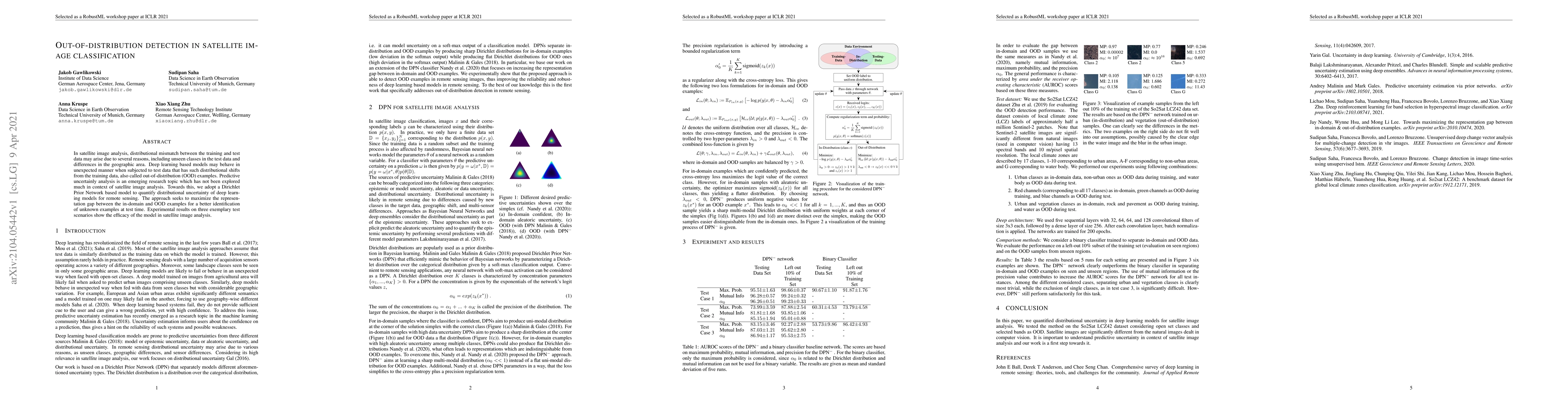
In satellite image analysis, distributional mismatch between the training and test data may arise due to several reasons, including unseen classes in the test data and differences in the geographic ...
In the last years we have witnessed the fields of geosciences and remote sensing and artificial intelligence to become closer. Thanks to both the massive availability of observational data, improved...
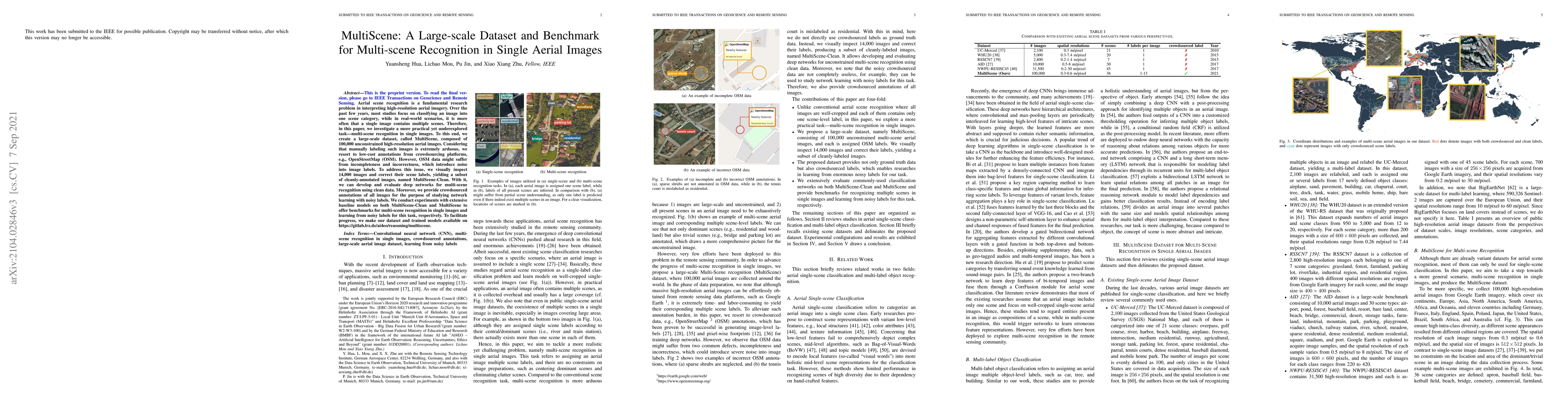
Aerial scene recognition is a fundamental research problem in interpreting high-resolution aerial imagery. Over the past few years, most studies focus on classifying an image into one scene category...
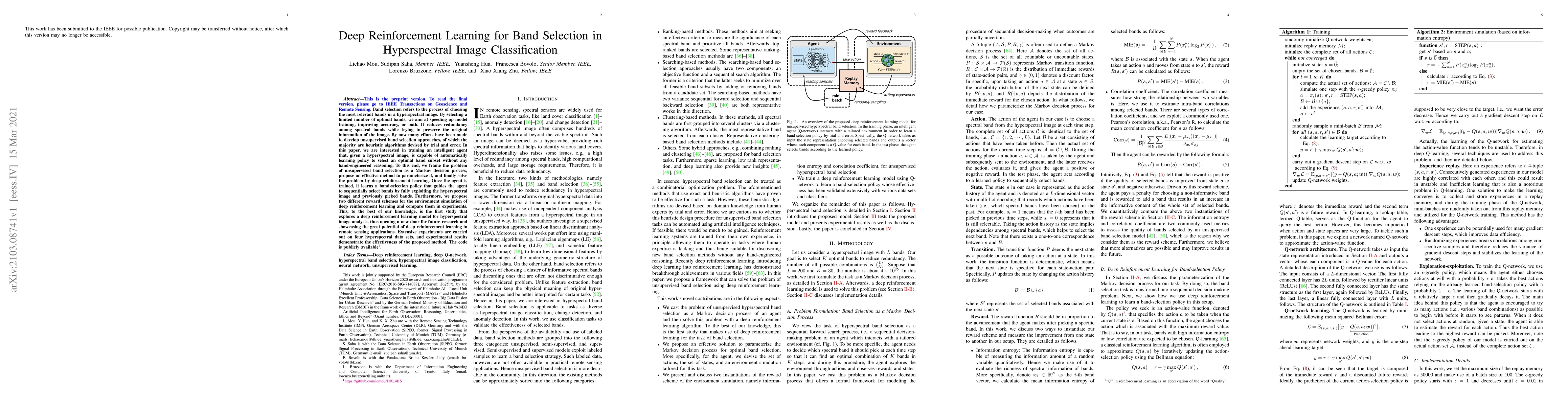
Band selection refers to the process of choosing the most relevant bands in a hyperspectral image. By selecting a limited number of optimal bands, we aim at speeding up model training, improving acc...
Most change detection methods assume that pre-change and post-change images are acquired by the same sensor. However, in many real-life scenarios, e.g., natural disaster, it is more practical to use...
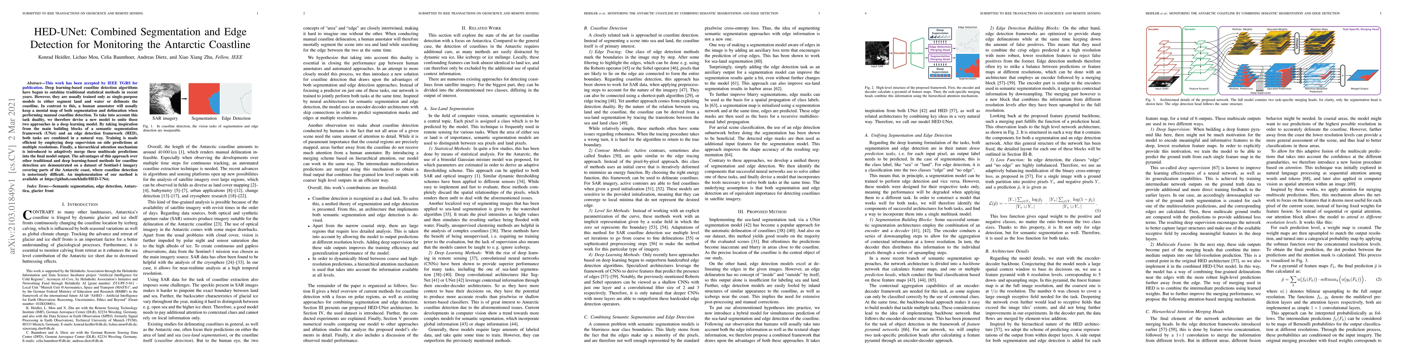
Deep learning-based coastline detection algorithms have begun to outshine traditional statistical methods in recent years. However, they are usually trained only as single-purpose models to either s...
Hyperspectral imaging, also known as image spectrometry, is a landmark technique in geoscience and remote sensing (RS). In the past decade, enormous efforts have been made to process and analyze the...
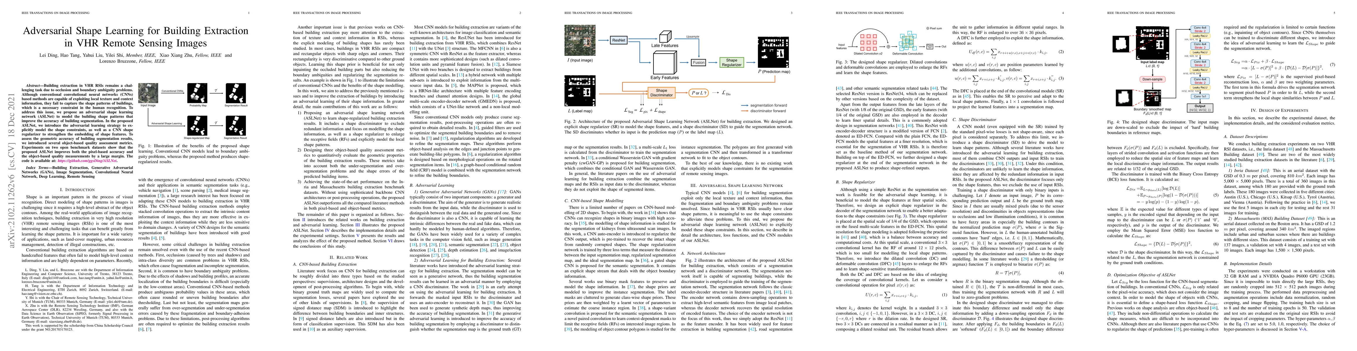
Building extraction in VHR RSIs remains a challenging task due to occlusion and boundary ambiguity problems. Although conventional convolutional neural networks (CNNs) based methods are capable of e...
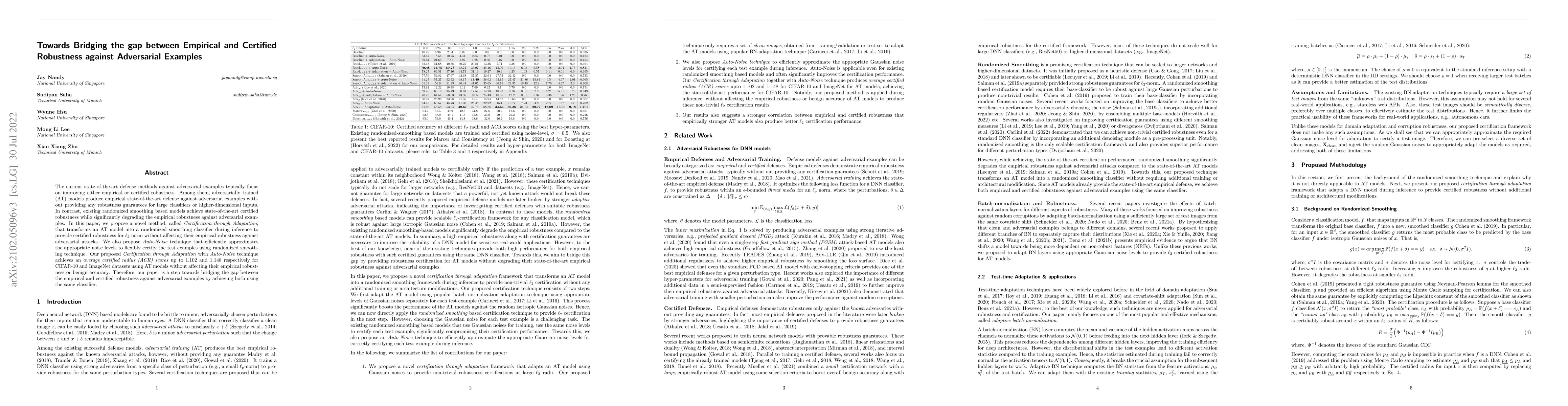
The current state-of-the-art defense methods against adversarial examples typically focus on improving either empirical or certified robustness. Among them, adversarially trained (AT) models produce...
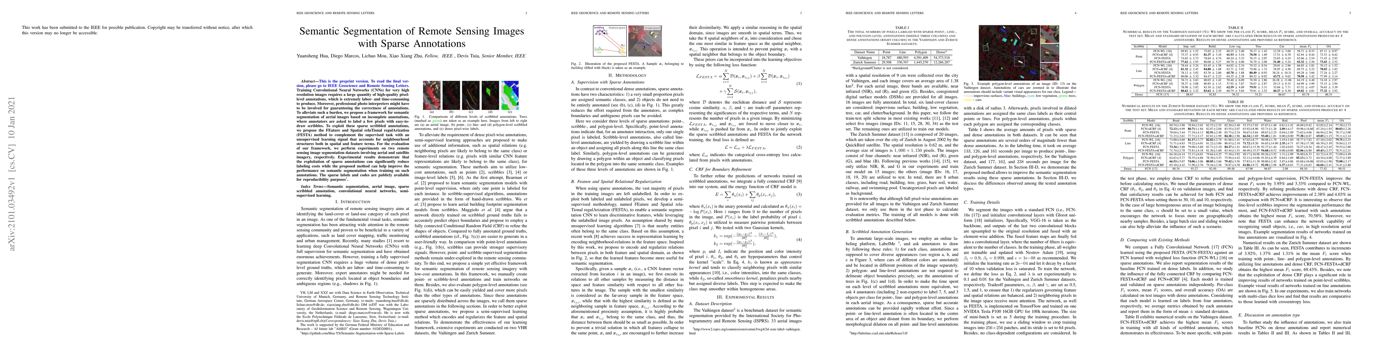
Training Convolutional Neural Networks (CNNs) for very high resolution images requires a large quantity of high-quality pixel-level annotations, which is extremely labor- and time-consuming to produ...
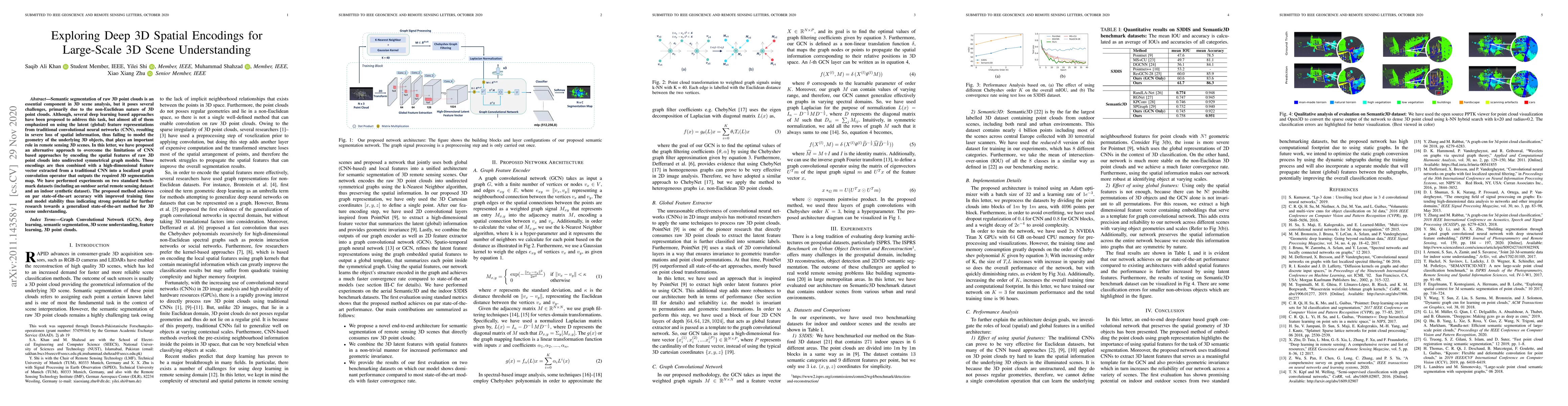
Semantic segmentation of raw 3D point clouds is an essential component in 3D scene analysis, but it poses several challenges, primarily due to the non-Euclidean nature of 3D point clouds. Although, ...
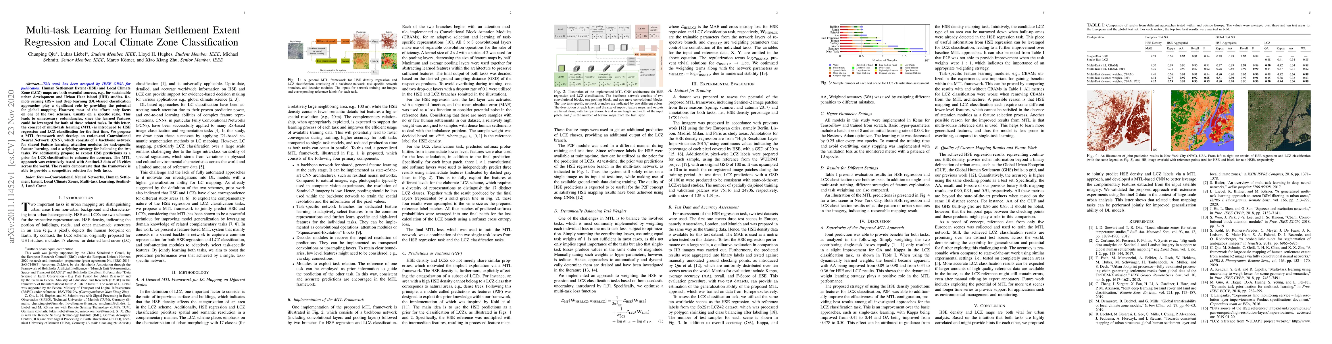
Human Settlement Extent (HSE) and Local Climate Zone (LCZ) maps are both essential sources, e.g., for sustainable urban development and Urban Heat Island (UHI) studies. Remote sensing (RS)- and deep...
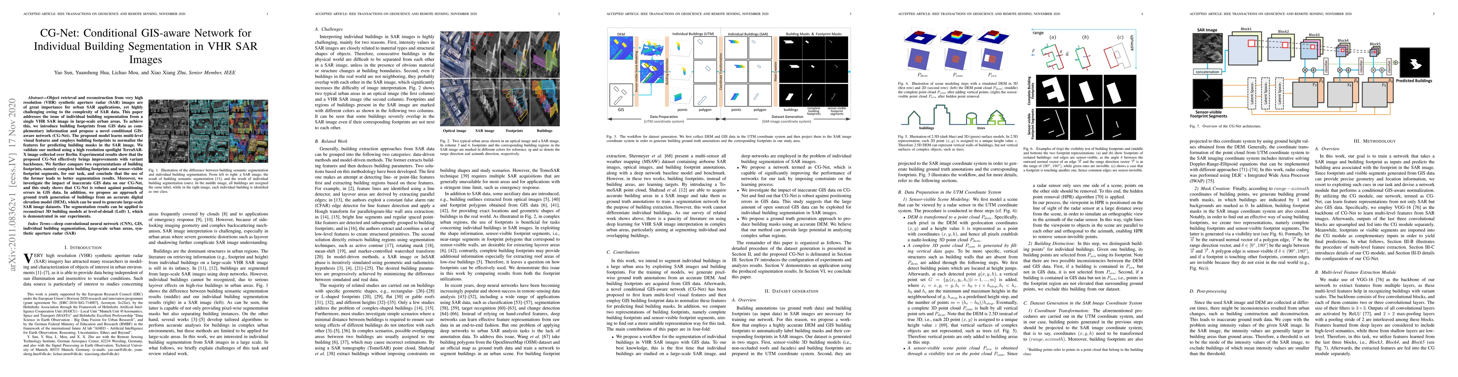
Object retrieval and reconstruction from very high resolution (VHR) synthetic aperture radar (SAR) images are of great importance for urban SAR applications, yet highly challenging owing to the comp...
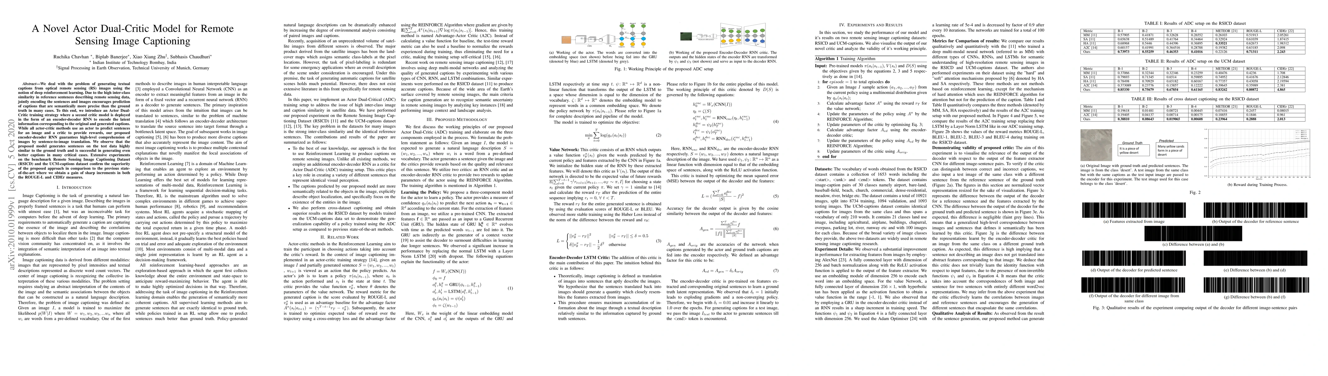
We deal with the problem of generating textual captions from optical remote sensing (RS) images using the notion of deep reinforcement learning. Due to the high inter-class similarity in reference s...
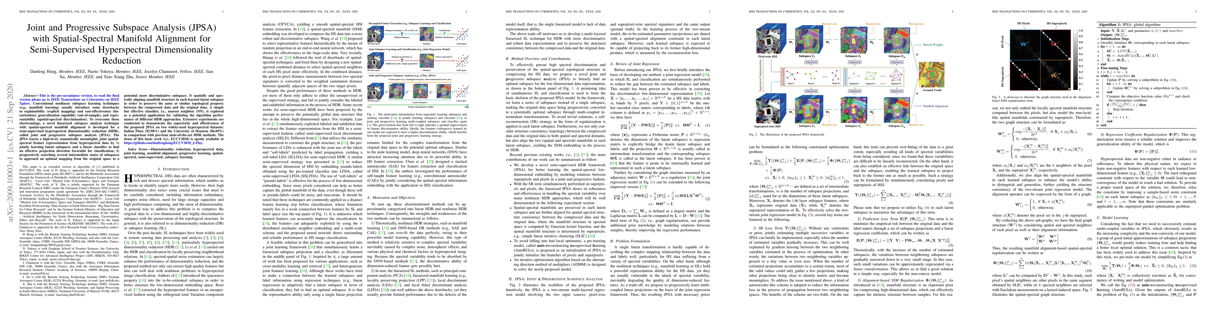
Conventional nonlinear subspace learning techniques (e.g., manifold learning) usually introduce some drawbacks in explainability (explicit mapping) and cost-effectiveness (linearization), generaliza...
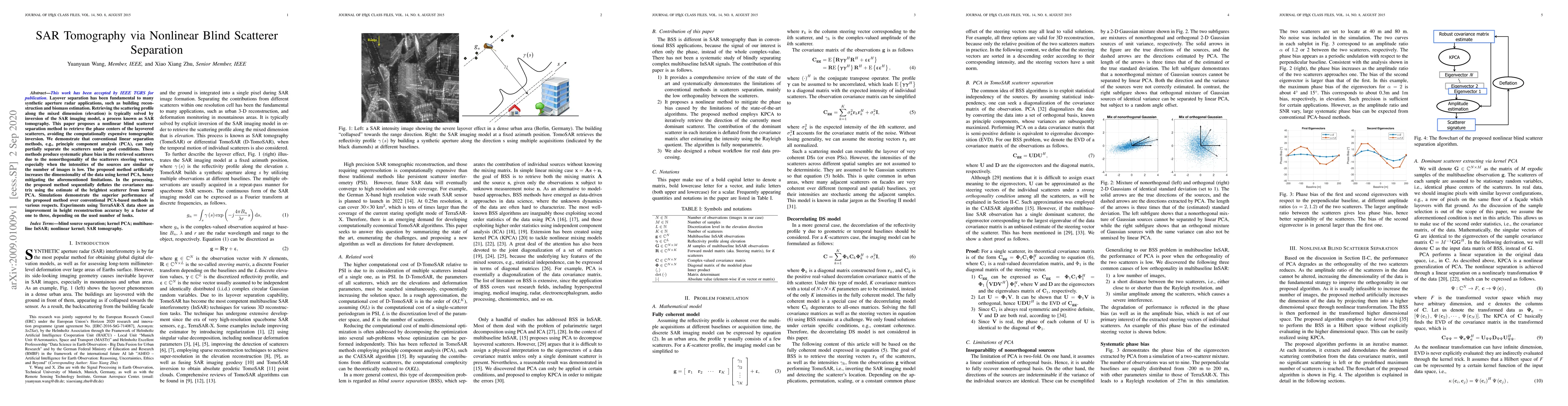
Layover separation has been fundamental to many synthetic aperture radar applications, such as building reconstruction and biomass estimation. Retrieving the scattering profile along the mixed dimen...
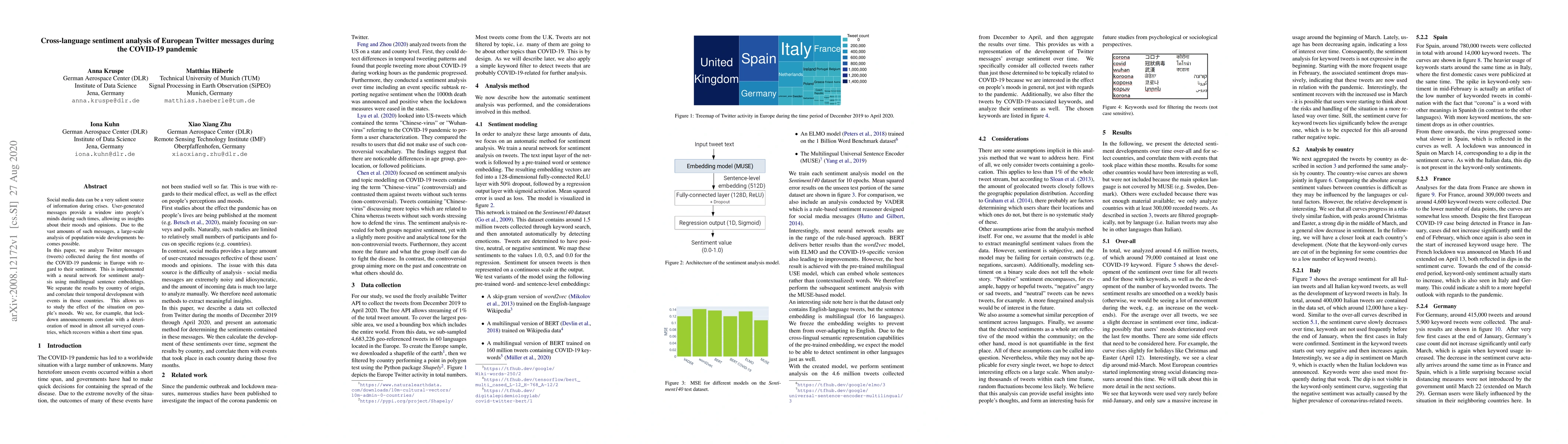
Social media data can be a very salient source of information during crises. User-generated messages provide a window into people's minds during such times, allowing us insights about their moods an...
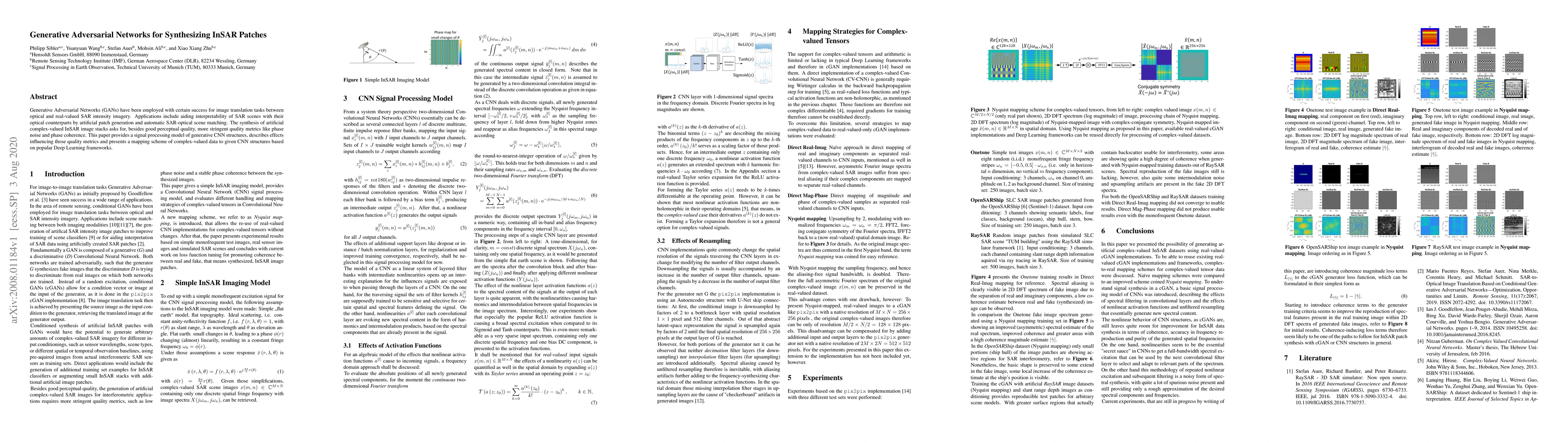
Generative Adversarial Networks (GANs) have been employed with certain success for image translation tasks between optical and real-valued SAR intensity imagery. Applications include aiding interpre...
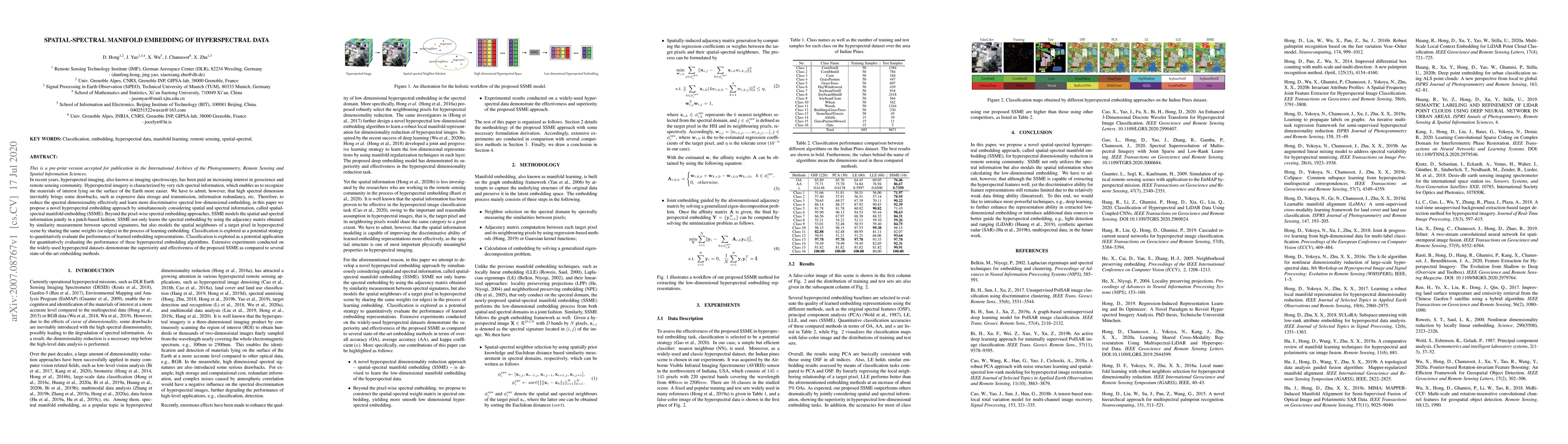
In recent years, hyperspectral imaging, also known as imaging spectroscopy, has been paid an increasing interest in geoscience and remote sensing community. Hyperspectral imagery is characterized by...
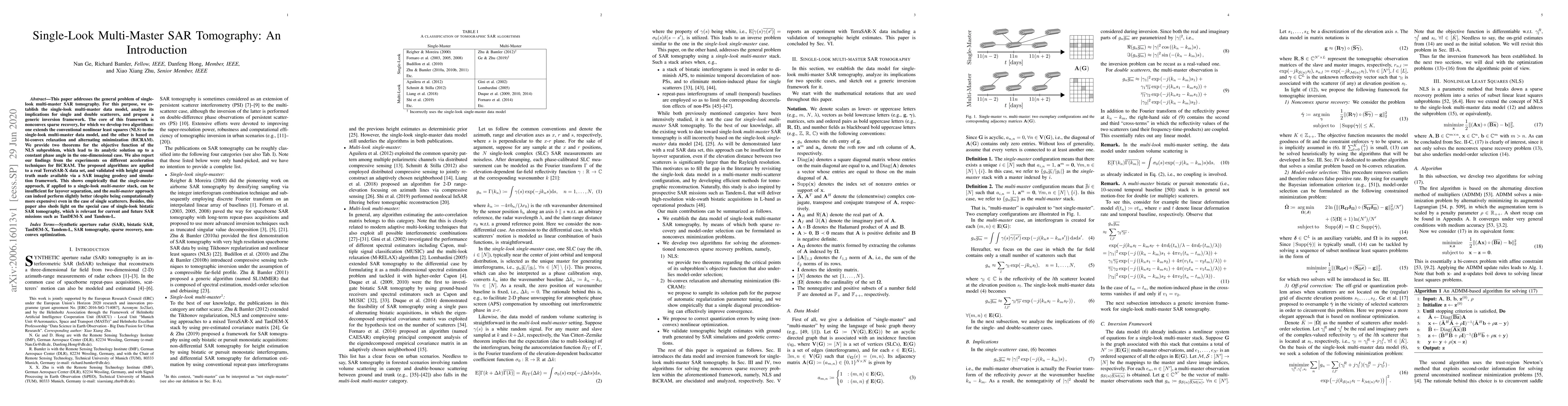
This paper addresses the general problem of single-look multi-master SAR tomography. For this purpose, we establish the single-look multi-master data model, analyze its implications for single and d...
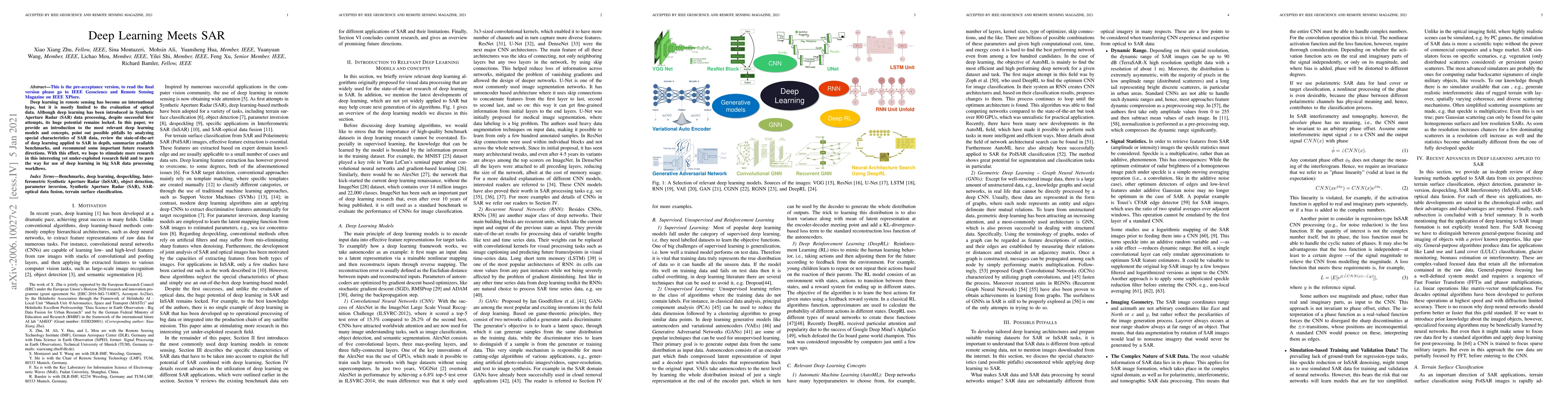
Deep learning in remote sensing has become an international hype, but it is mostly limited to the evaluation of optical data. Although deep learning has been introduced in Synthetic Aperture Radar (...
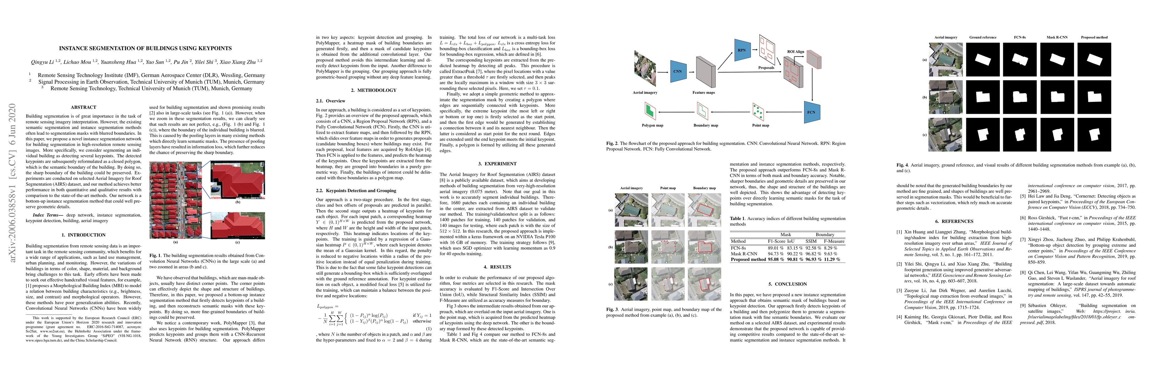
Building segmentation is of great importance in the task of remote sensing imagery interpretation. However, the existing semantic segmentation and instance segmentation methods often lead to segment...
As a unique classification scheme for urban forms and functions, the local climate zone (LCZ) system provides essential general information for any studies related to urban environments, especially ...
Visual crowd counting has been recently studied as a way to enable people counting in crowd scenes from images. Albeit successful, vision-based crowd counting approaches could fail to capture inform...
Multi-baseline interferometric synthetic aperture radar (InSAR) techniques are effective approaches for retrieving the 3-D information of urban areas. In order to obtain a plausible reconstruction, ...
Building footprint maps are vital to many remote sensing applications, such as 3D building modeling, urban planning, and disaster management. Due to the complexity of buildings, the accurate and rel...
Multipass SAR interferometry (InSAR) techniques based on meter-resolution spaceborne SAR satellites, such as TerraSAR-X or COSMO-Skymed, provide 3D reconstruction and the measurement of ground displ...
Access to labeled reference data is one of the grand challenges in supervised machine learning endeavors. This is especially true for an automated analysis of remote sensing images on a global scale...
Up to the present, an enormous number of advanced techniques have been developed to enhance and extract the spatially semantic information in hyperspectral image processing and analysis. However, lo...
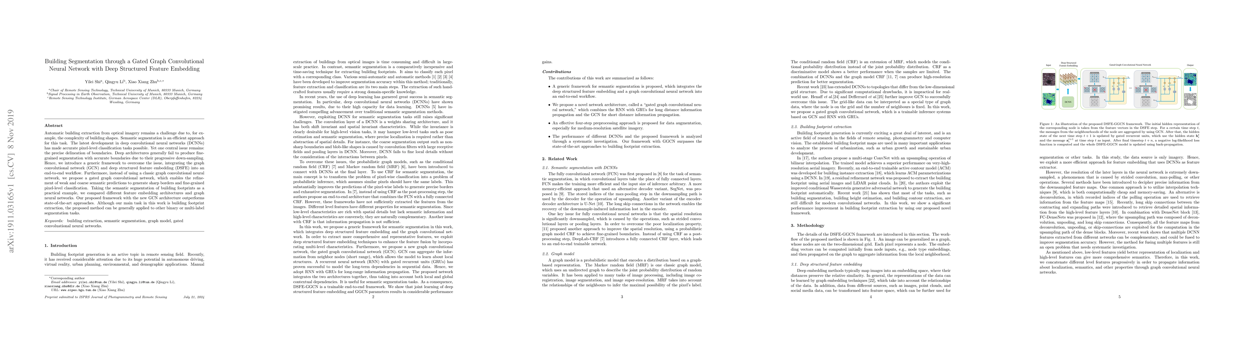
Automatic building extraction from optical imagery remains a challenge due to, for example, the complexity of building shapes. Semantic segmentation is an efficient approach for this task. The lates...
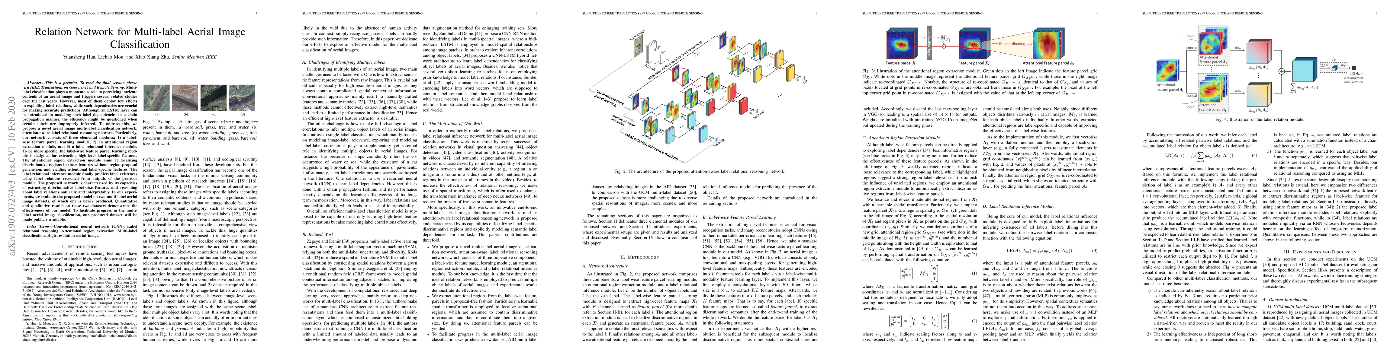
Multi-label classification plays a momentous role in perceiving intricate contents of an aerial image and triggers several related studies over the last years. However, most of them deploy few effor...
The availability of curated large-scale training data is a crucial factor for the development of well-generalizing deep learning methods for the extraction of geoinformation from multi-sensor remote...
Multi-modal data fusion has recently been shown promise in classification tasks in remote sensing. Optical data and radar data, two important yet intrinsically different data sources, are attracting...
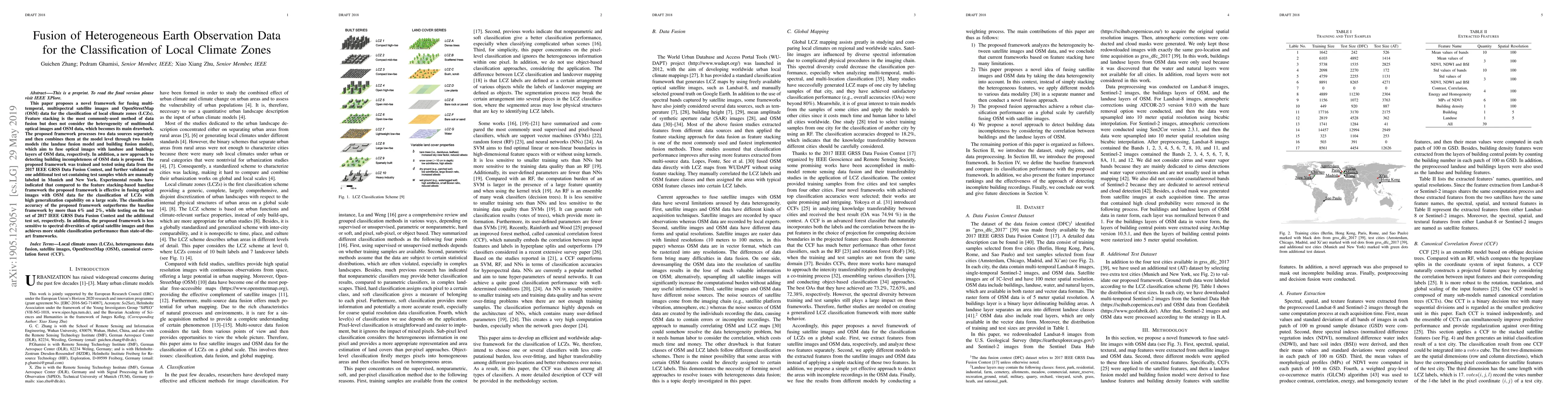
This paper proposes a novel framework for fusing multi-temporal, multispectral satellite images and OpenStreetMap (OSM) data for the classification of local climate zones (LCZs). Feature stacking is...
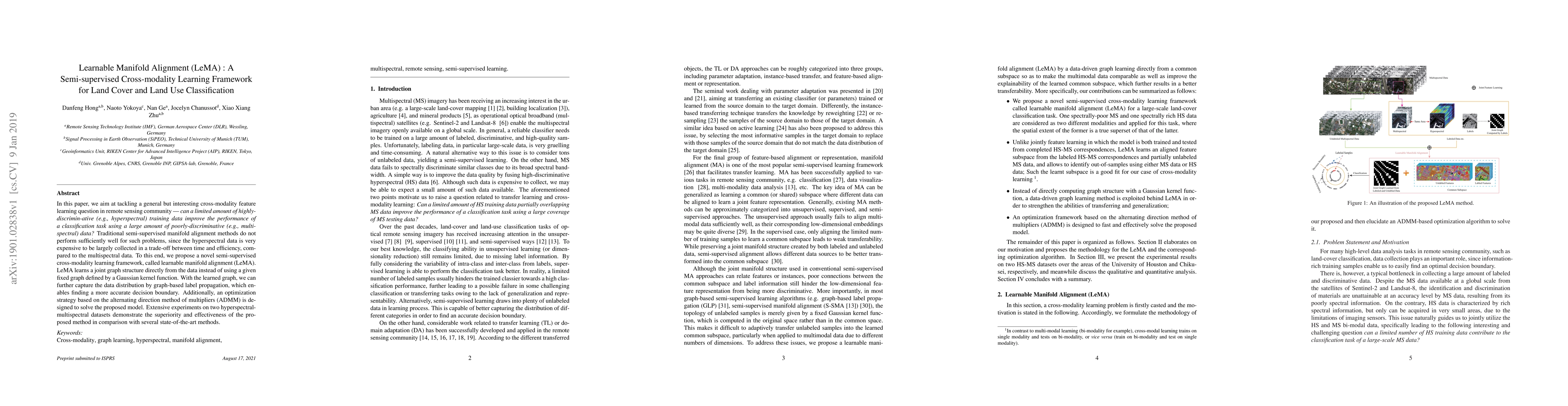
In this paper, we aim at tackling a general but interesting cross-modality feature learning question in remote sensing community --- can a limited amount of highly-discrimin-ative (e.g., hyperspectr...
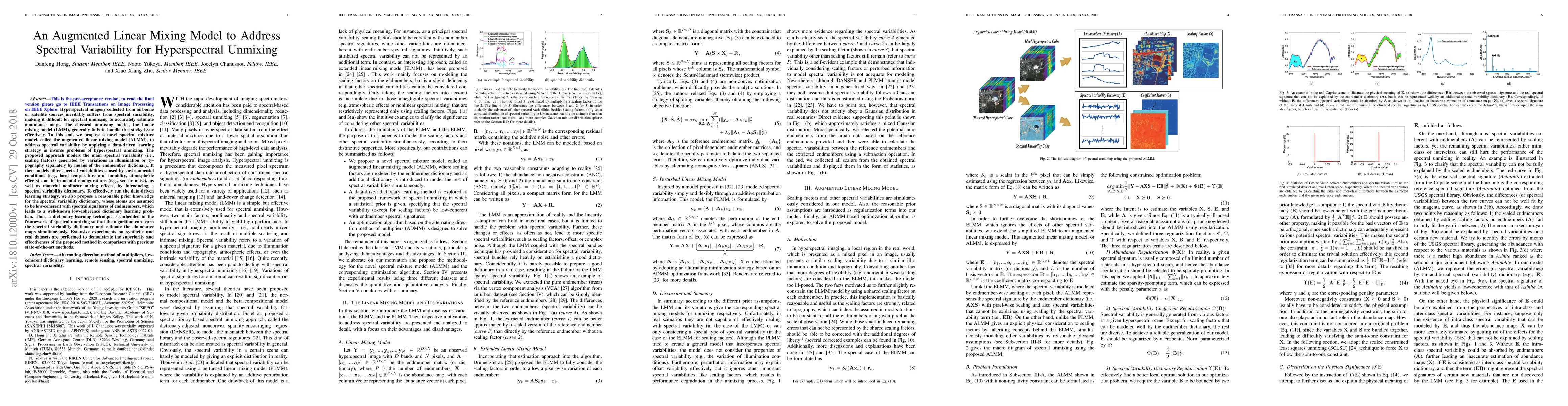
Hyperspectral imagery collected from airborne or satellite sources inevitably suffers from spectral variability, making it difficult for spectral unmixing to accurately estimate abundance maps. The ...
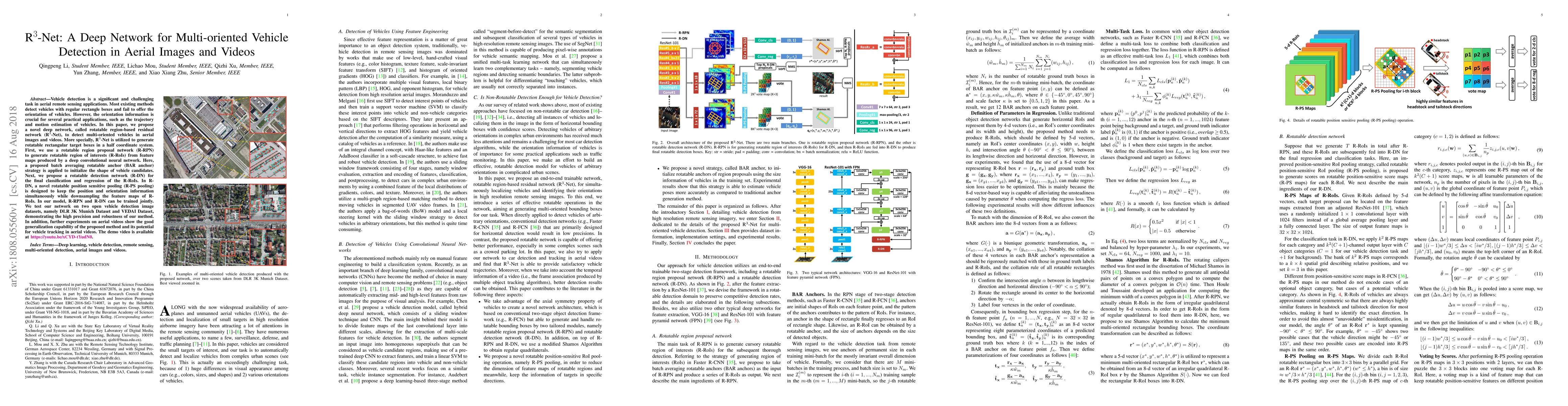
Vehicle detection is a significant and challenging task in aerial remote sensing applications. Most existing methods detect vehicles with regular rectangle boxes and fail to offer the orientation of...
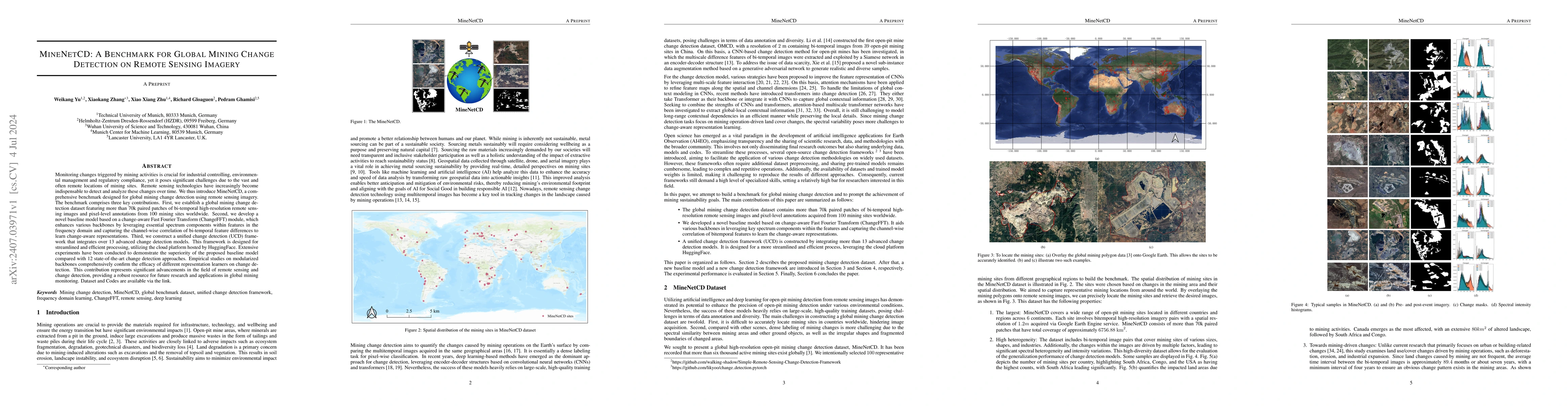
Monitoring changes triggered by mining activities is crucial for industrial controlling, environmental management and regulatory compliance, yet it poses significant challenges due to the vast and oft...
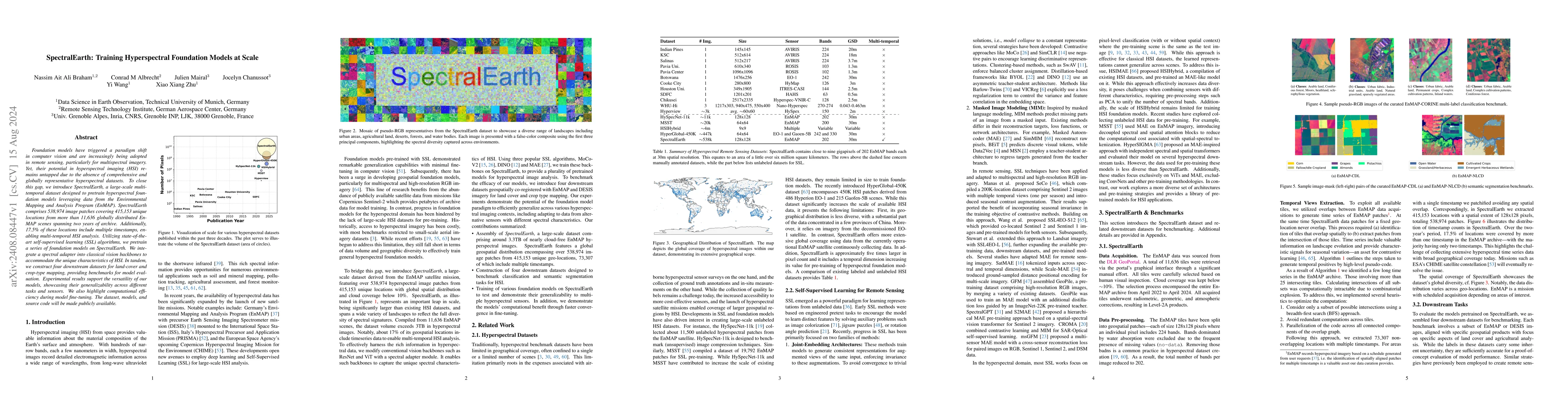
Foundation models have triggered a paradigm shift in computer vision and are increasingly being adopted in remote sensing, particularly for multispectral imagery. Yet, their potential in hyperspectral...
Methane ($CH_4$) is a potent anthropogenic greenhouse gas, contributing 86 times more to global warming than Carbon Dioxide ($CO_2$) over 20 years, and it also acts as an air pollutant. Given its high...
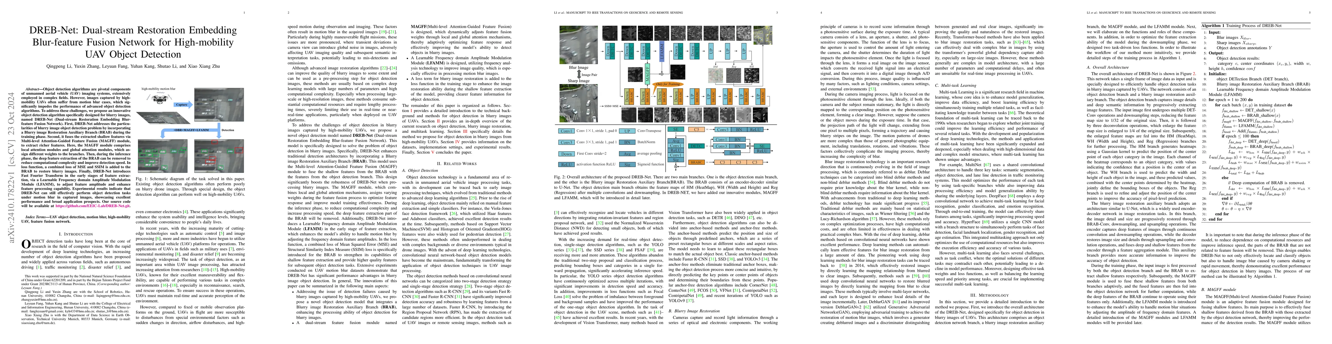
Object detection algorithms are pivotal components of unmanned aerial vehicle (UAV) imaging systems, extensively employed in complex fields. However, images captured by high-mobility UAVs often suffer...
Earth Observation (EO) data analysis has been significantly revolutionized by deep learning (DL), with applications typically limited to grid-like data structures. Graph Neural Networks (GNNs) emerge ...
Uncertainty quantification (UQ) is essential for assessing the reliability of Earth observation (EO) products. However, the extensive use of machine learning models in EO introduces an additional laye...
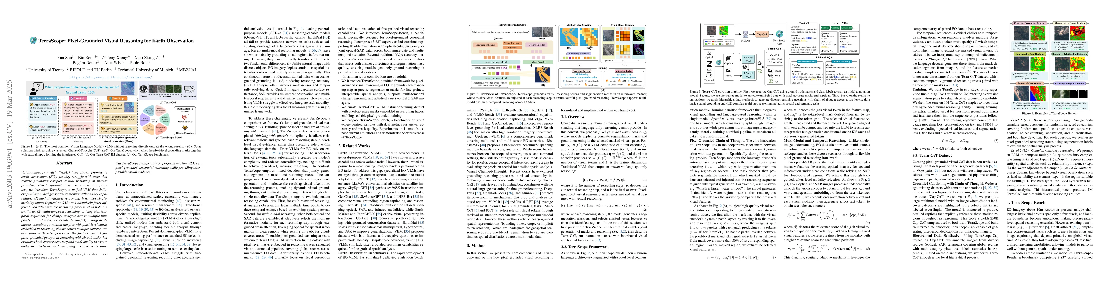
The rapid evolution of Vision Language Models (VLMs) has catalyzed significant advancements in artificial intelligence, expanding research across various disciplines, including Earth Observation (EO)....
Object extraction and segmentation from remote sensing (RS) images is a critical yet challenging task in urban environment monitoring. Urban morphology is inherently complex, with irregular objects of...
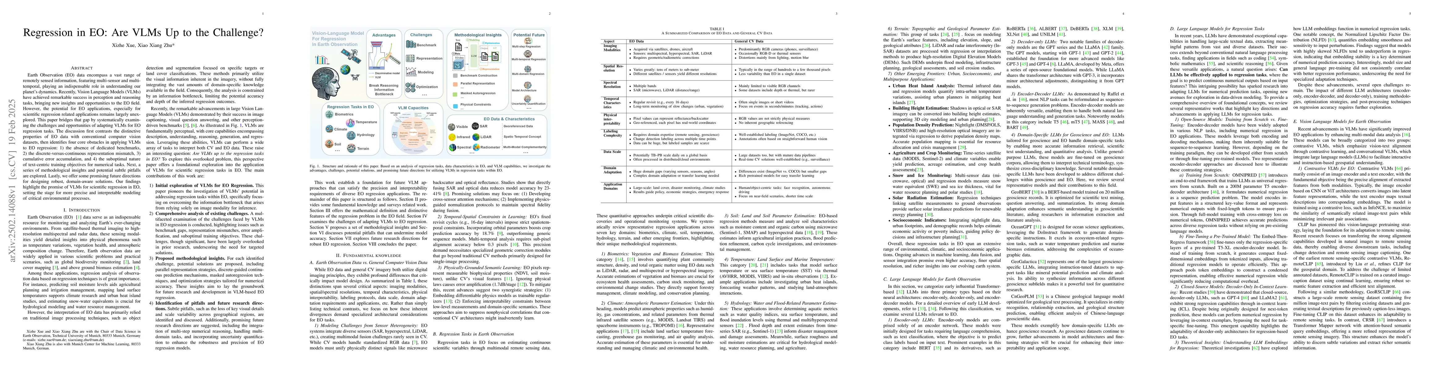
Earth Observation (EO) data encompass a vast range of remotely sensed information, featuring multi-sensor and multi-temporal, playing an indispensable role in understanding our planet's dynamics. Rece...
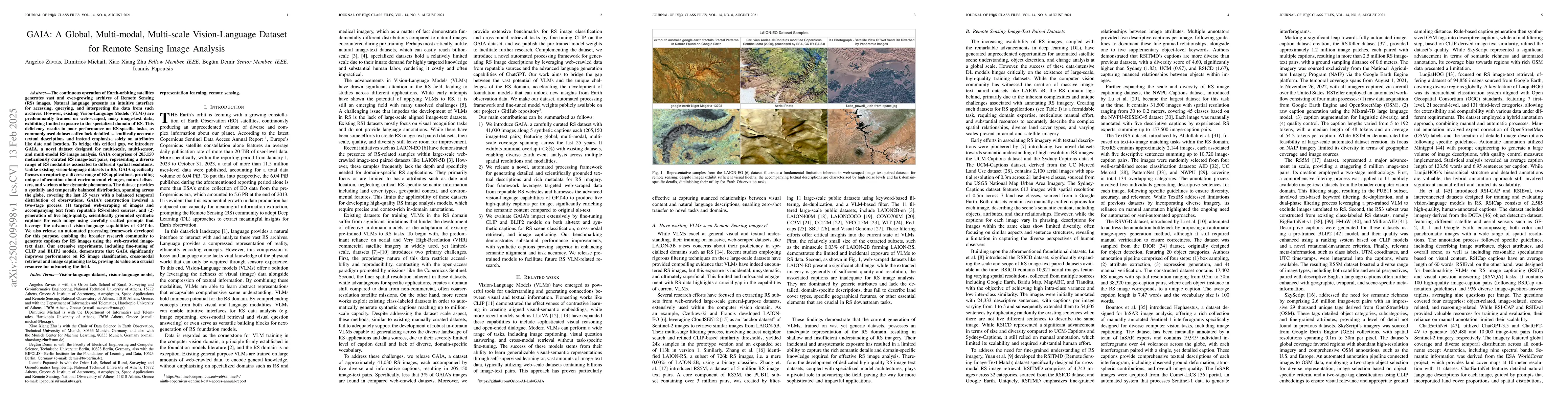
The continuous operation of Earth-orbiting satellites generates vast and ever-growing archives of Remote Sensing (RS) images. Natural language presents an intuitive interface for accessing, querying, ...
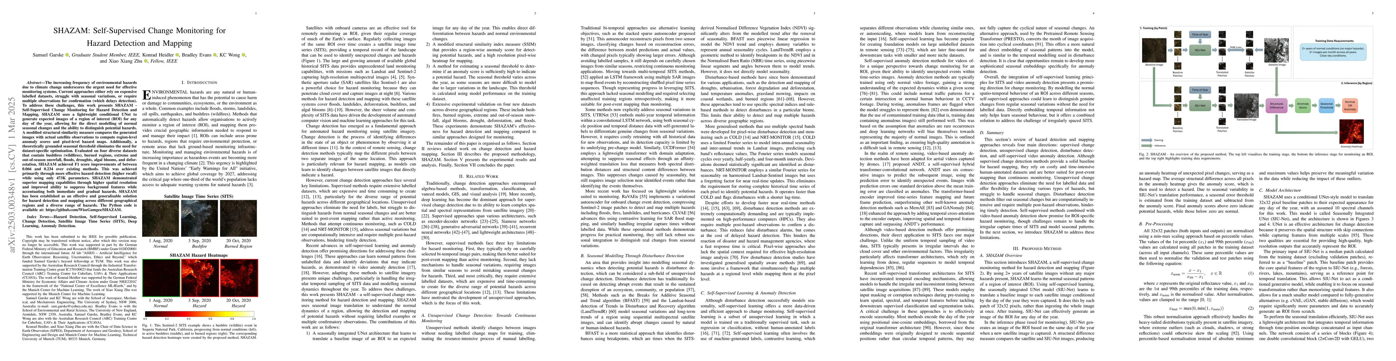
The increasing frequency of environmental hazards due to climate change underscores the urgent need for effective monitoring systems. Current approaches either rely on expensive labelled datasets, str...
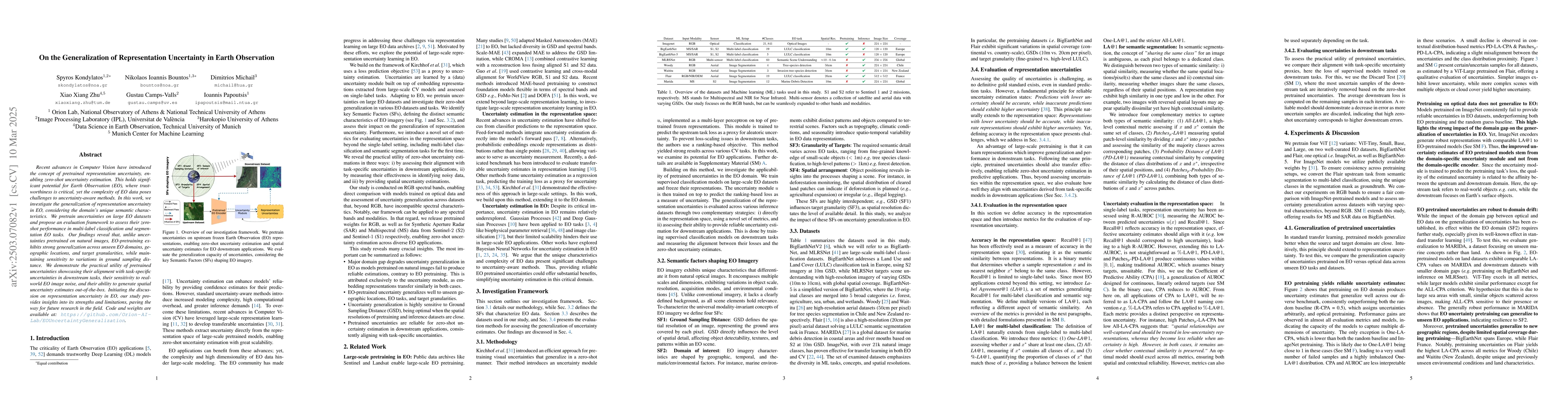
Recent advances in Computer Vision have introduced the concept of pretrained representation uncertainty, enabling zero-shot uncertainty estimation. This holds significant potential for Earth Observati...
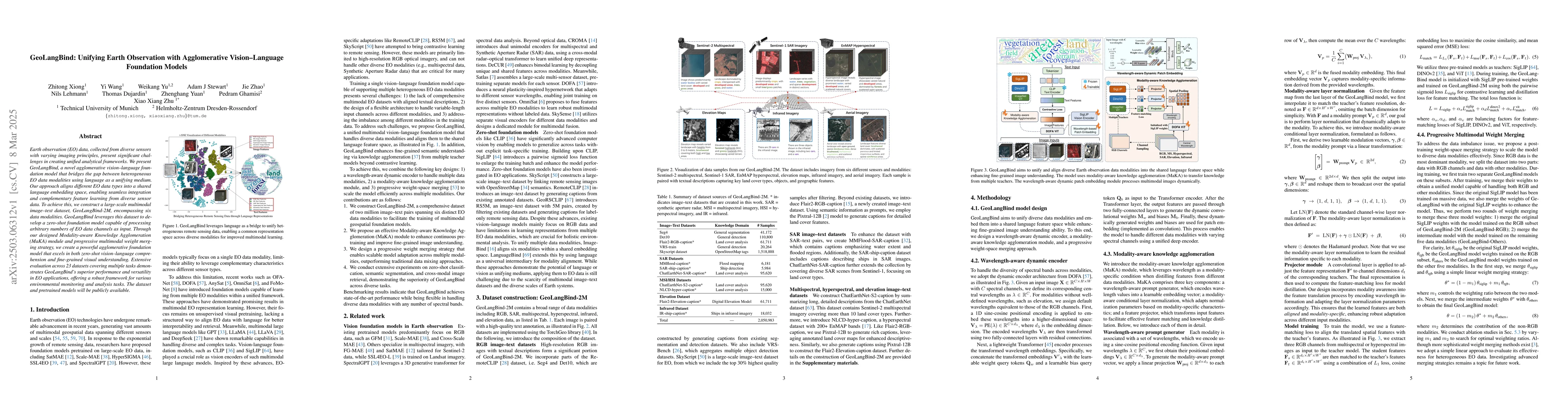
Earth observation (EO) data, collected from diverse sensors with varying imaging principles, present significant challenges in creating unified analytical frameworks. We present GeoLangBind, a novel a...
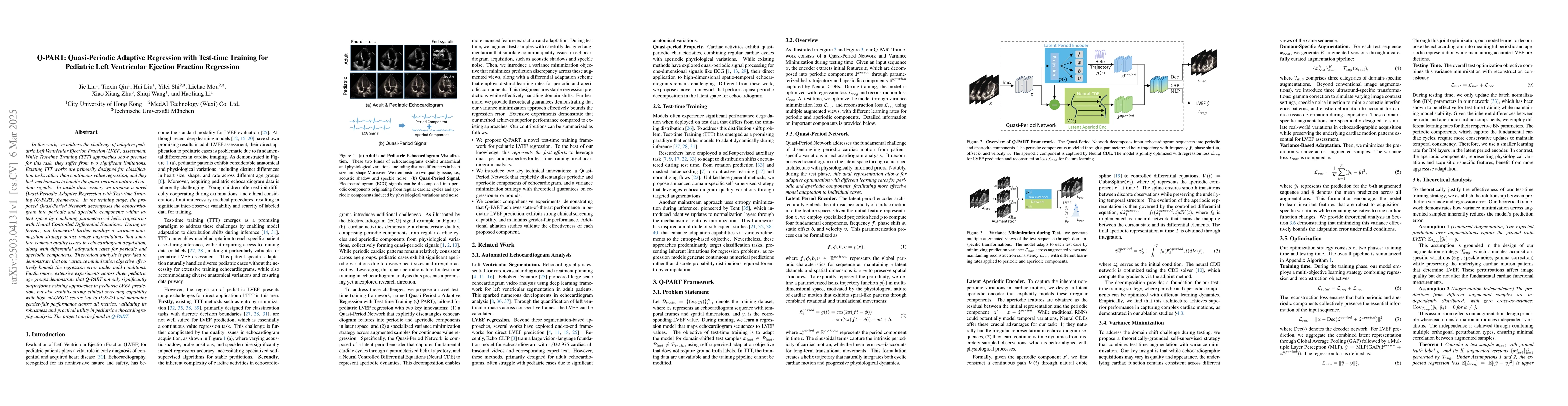
In this work, we address the challenge of adaptive pediatric Left Ventricular Ejection Fraction (LVEF) assessment. While Test-time Training (TTT) approaches show promise for this task, they suffer fro...
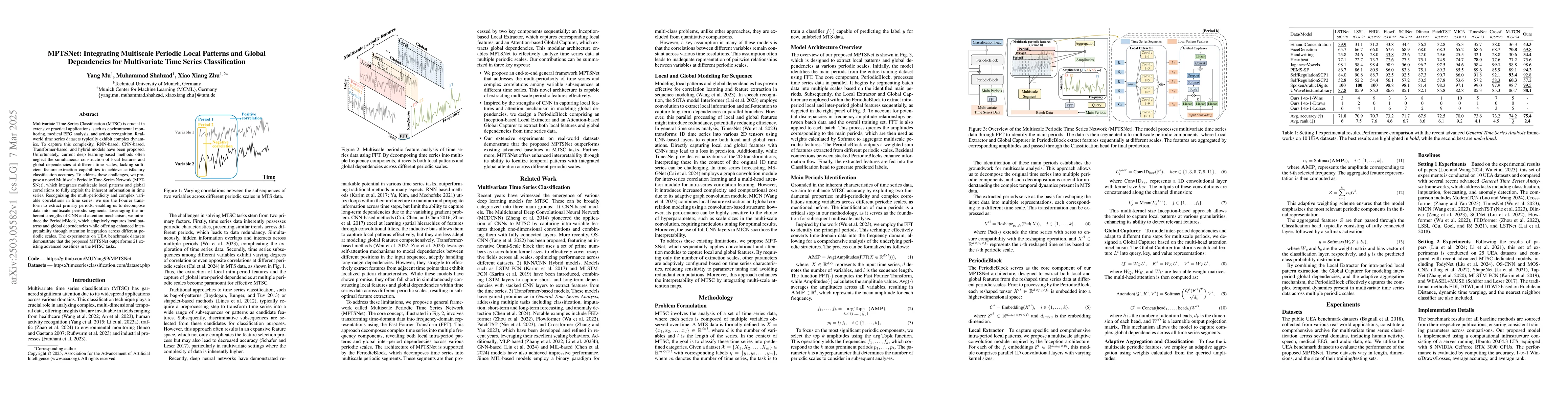
Multivariate Time Series Classification (MTSC) is crucial in extensive practical applications, such as environmental monitoring, medical EEG analysis, and action recognition. Real-world time series da...
Ultrasound video classification enables automated diagnosis and has emerged as an important research area. However, publicly available ultrasound video datasets remain scarce, hindering progress in de...
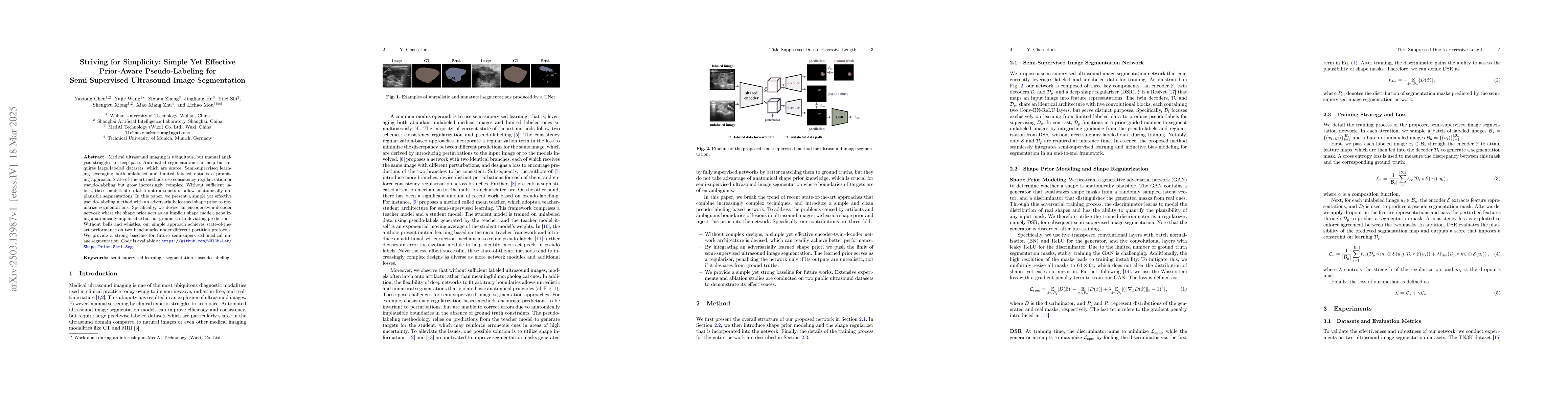
Medical ultrasound imaging is ubiquitous, but manual analysis struggles to keep pace. Automated segmentation can help but requires large labeled datasets, which are scarce. Semi-supervised learning le...
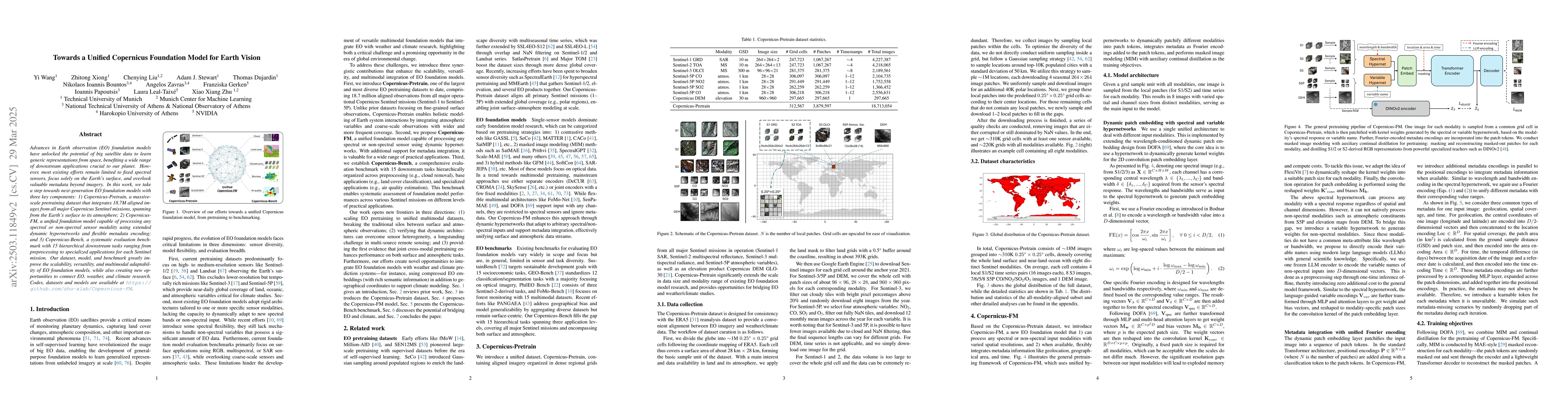
Advances in Earth observation (EO) foundation models have unlocked the potential of big satellite data to learn generic representations from space, benefiting a wide range of downstream applications c...
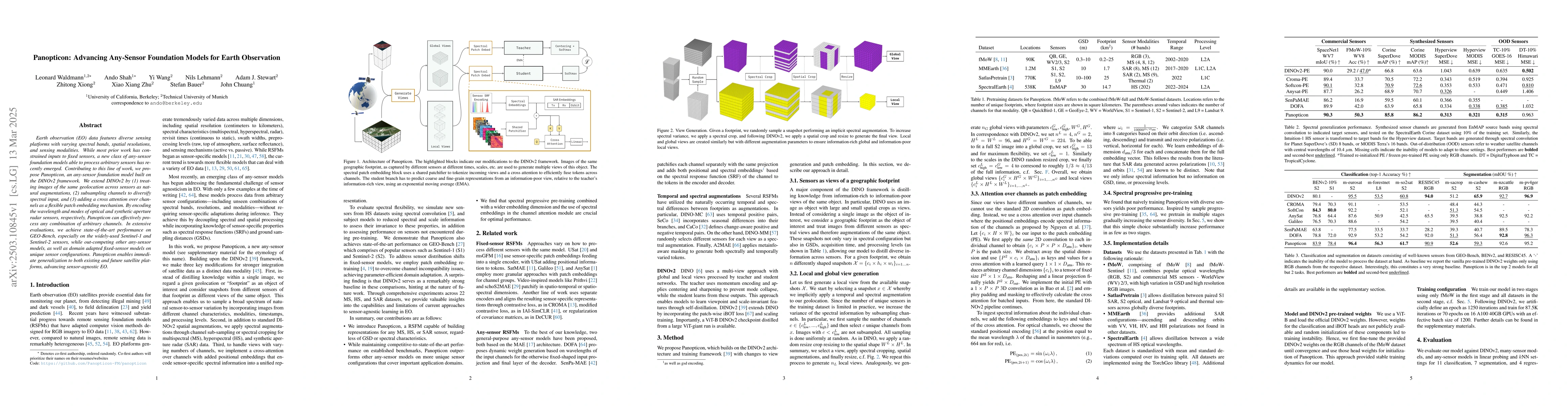
Earth observation (EO) data features diverse sensing platforms with varying spectral bands, spatial resolutions, and sensing modalities. While most prior work has constrained inputs to fixed sensors, ...
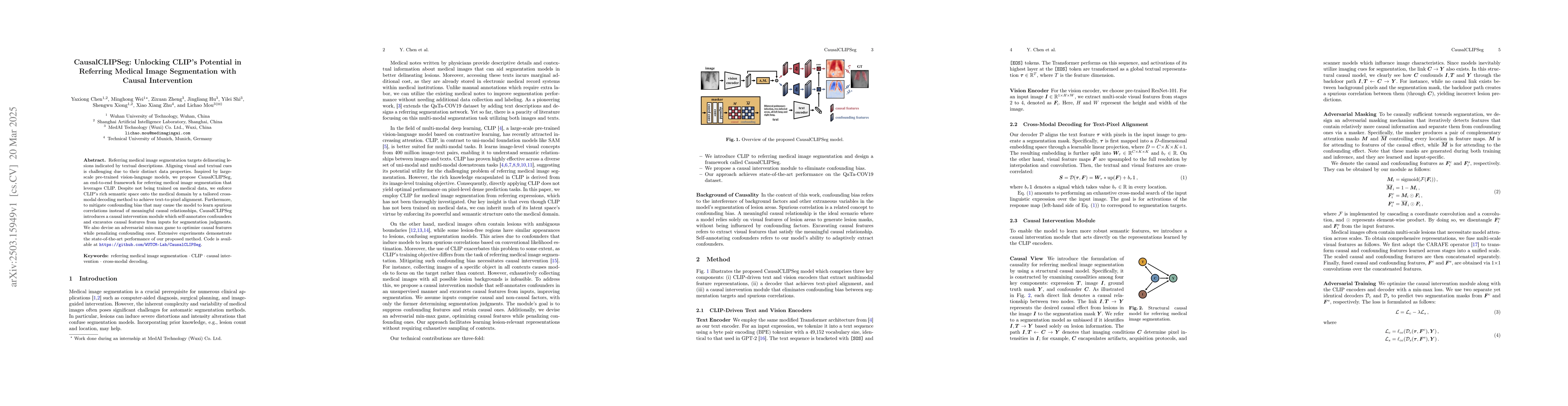
Referring medical image segmentation targets delineating lesions indicated by textual descriptions. Aligning visual and textual cues is challenging due to their distinct data properties. Inspired by l...
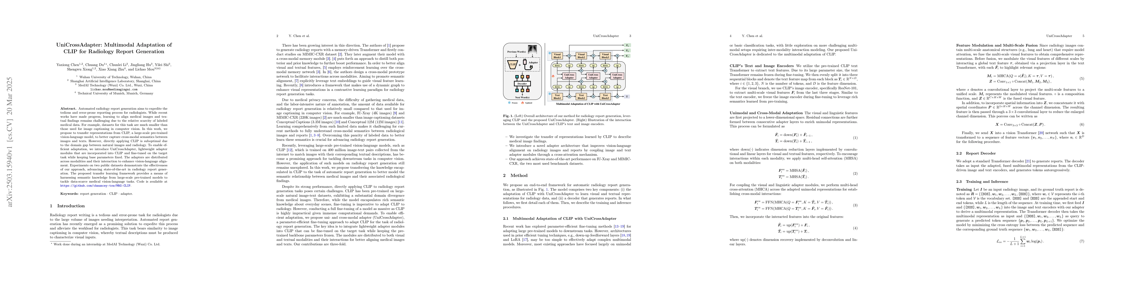
Automated radiology report generation aims to expedite the tedious and error-prone reporting process for radiologists. While recent works have made progress, learning to align medical images and textu...
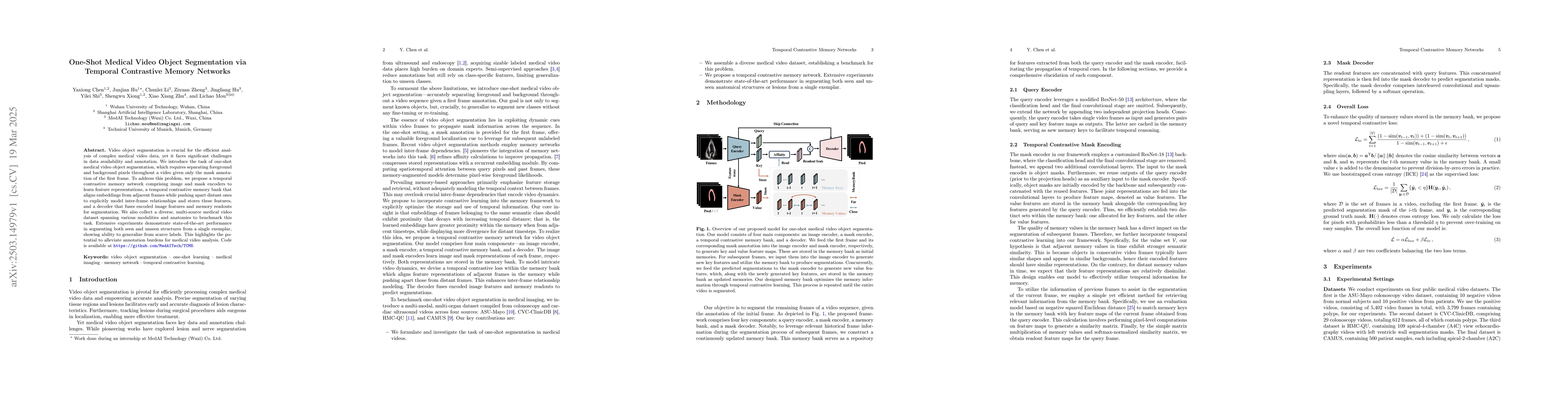
Video object segmentation is crucial for the efficient analysis of complex medical video data, yet it faces significant challenges in data availability and annotation. We introduce the task of one-sho...

Few-shot video object segmentation aims to reduce annotation costs; however, existing methods still require abundant dense frame annotations for training, which are scarce in the medical domain. We in...
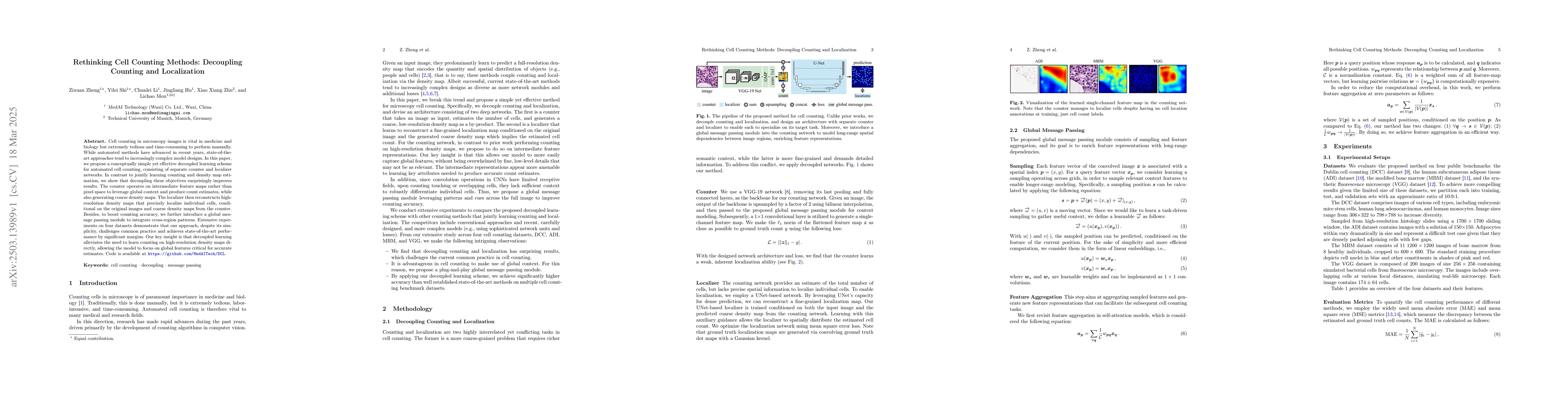
Cell counting in microscopy images is vital in medicine and biology but extremely tedious and time-consuming to perform manually. While automated methods have advanced in recent years, state-of-the-ar...
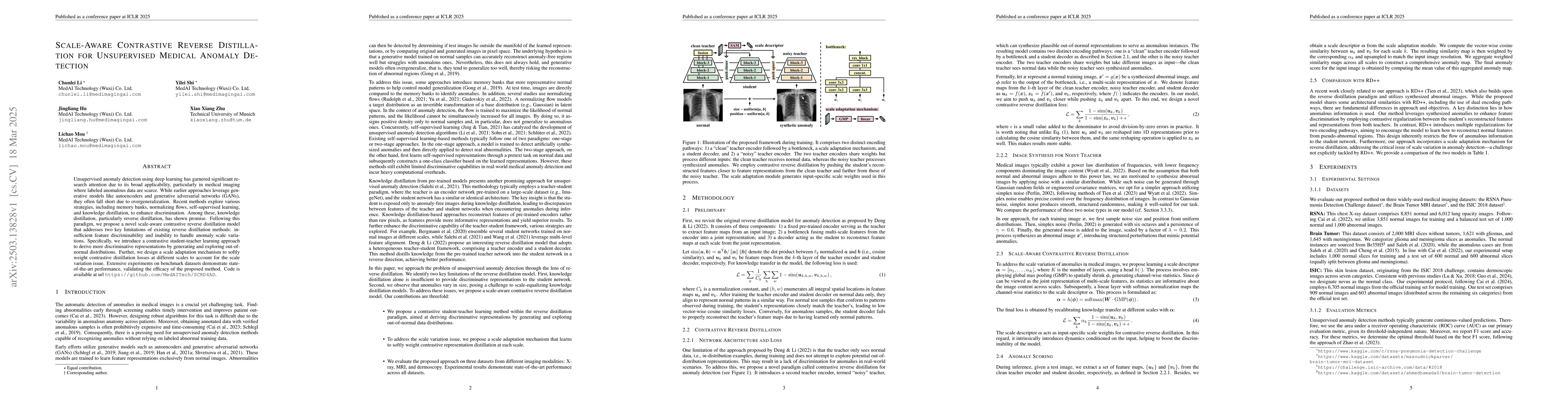
Unsupervised anomaly detection using deep learning has garnered significant research attention due to its broad applicability, particularly in medical imaging where labeled anomalous data are scarce. ...
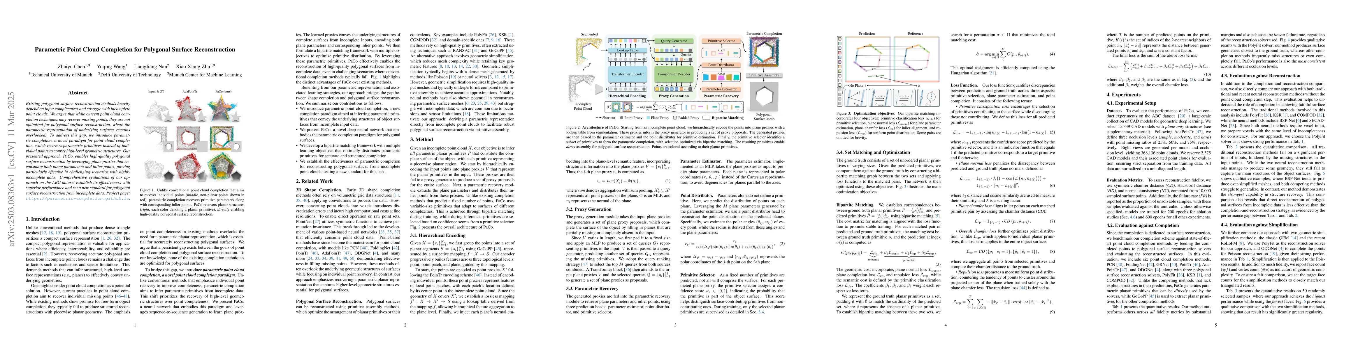
Existing polygonal surface reconstruction methods heavily depend on input completeness and struggle with incomplete point clouds. We argue that while current point cloud completion techniques may reco...
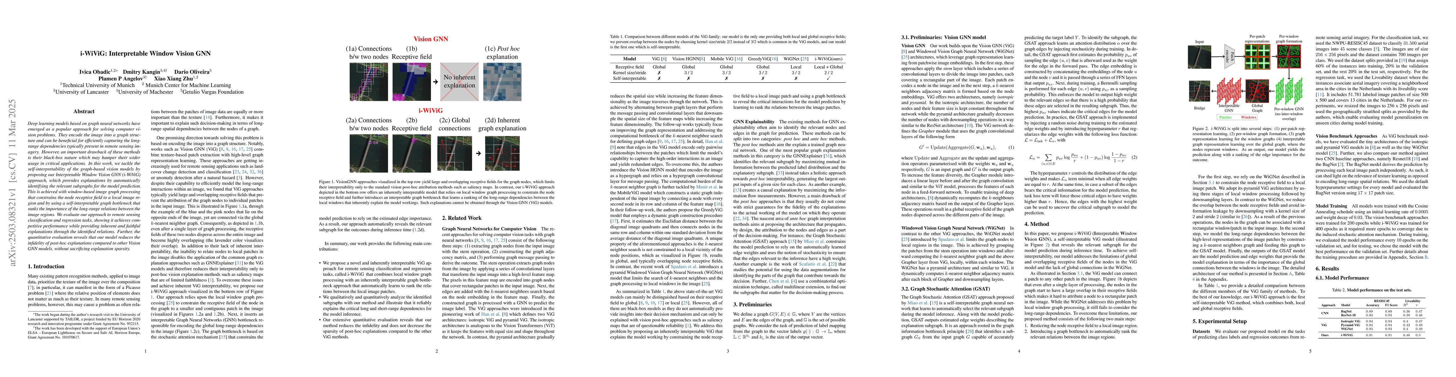
Deep learning models based on graph neural networks have emerged as a popular approach for solving computer vision problems. They encode the image into a graph structure and can be beneficial for effi...
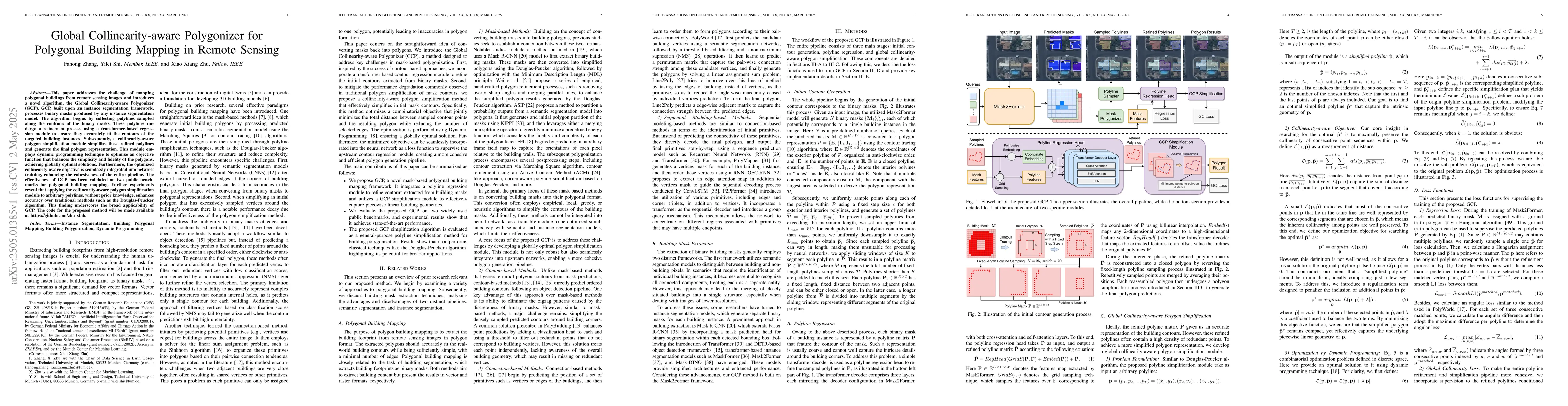
This paper addresses the challenge of mapping polygonal buildings from remote sensing images and introduces a novel algorithm, the Global Collinearity-aware Polygonizer (GCP). GCP, built upon an insta...
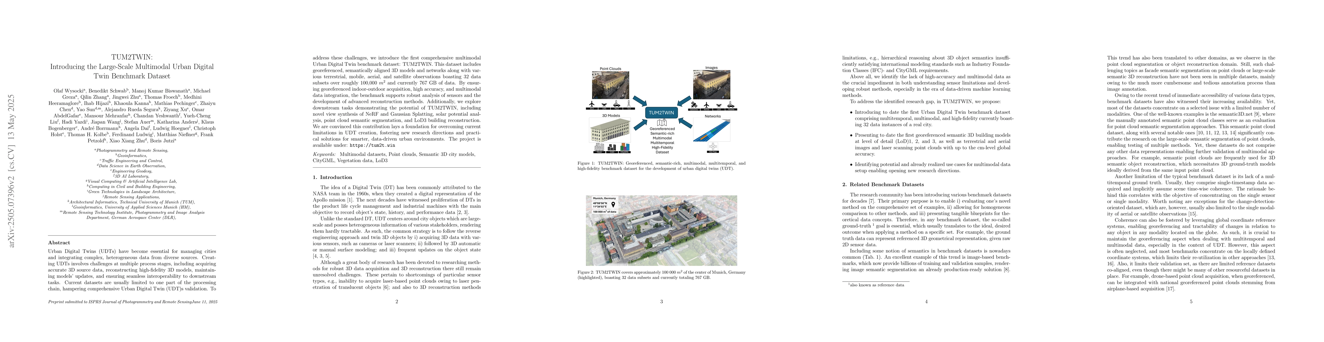
Urban Digital Twins (UDTs) have become essential for managing cities and integrating complex, heterogeneous data from diverse sources. Creating UDTs involves challenges at multiple process stages, inc...
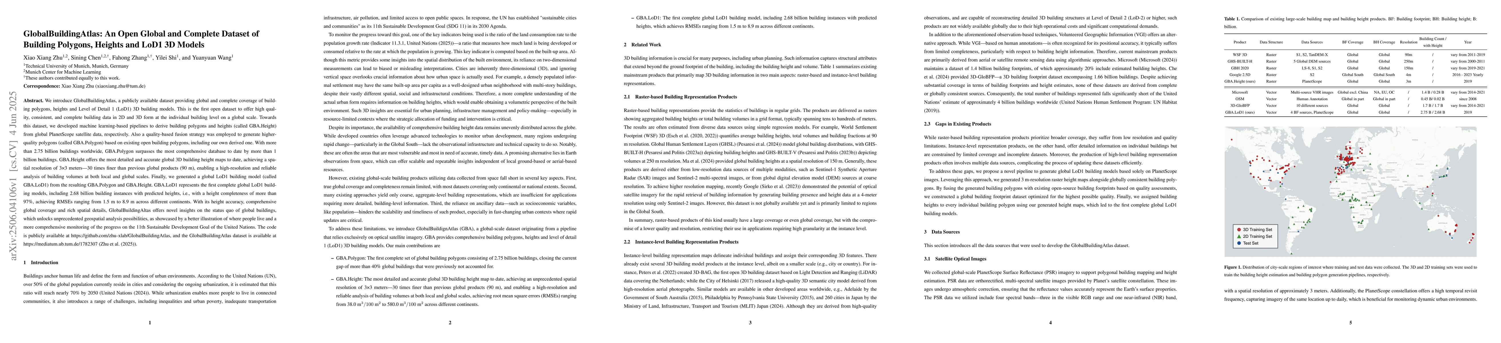
We introduce GlobalBuildingAtlas, a publicly available dataset providing global and complete coverage of building polygons, heights and Level of Detail 1 (LoD1) 3D building models. This is the first o...
Monocular height estimation is considered the most efficient and cost-effective means of 3D perception in remote sensing, and it has attracted much attention since the emergence of deep learning. Whil...
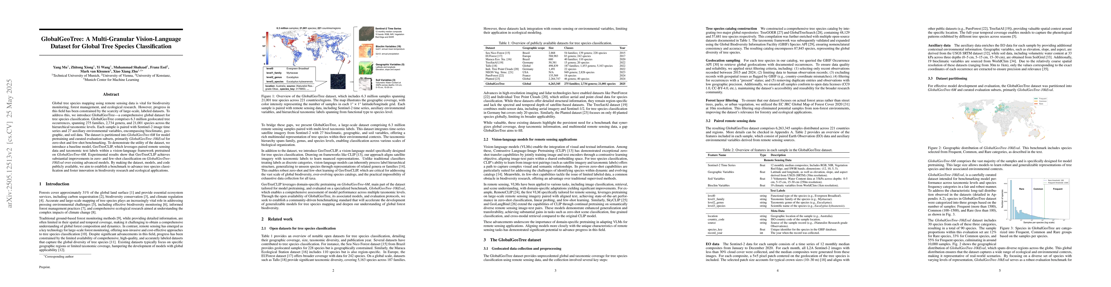
Global tree species mapping using remote sensing data is vital for biodiversity monitoring, forest management, and ecological research. However, progress in this field has been constrained by the scar...
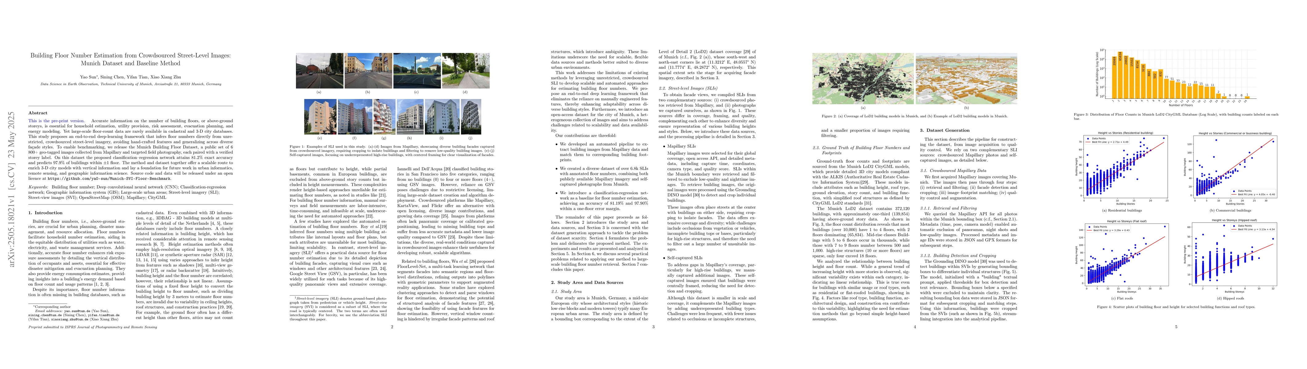
Accurate information on the number of building floors, or above-ground storeys, is essential for household estimation, utility provision, risk assessment, evacuation planning, and energy modeling. Yet...
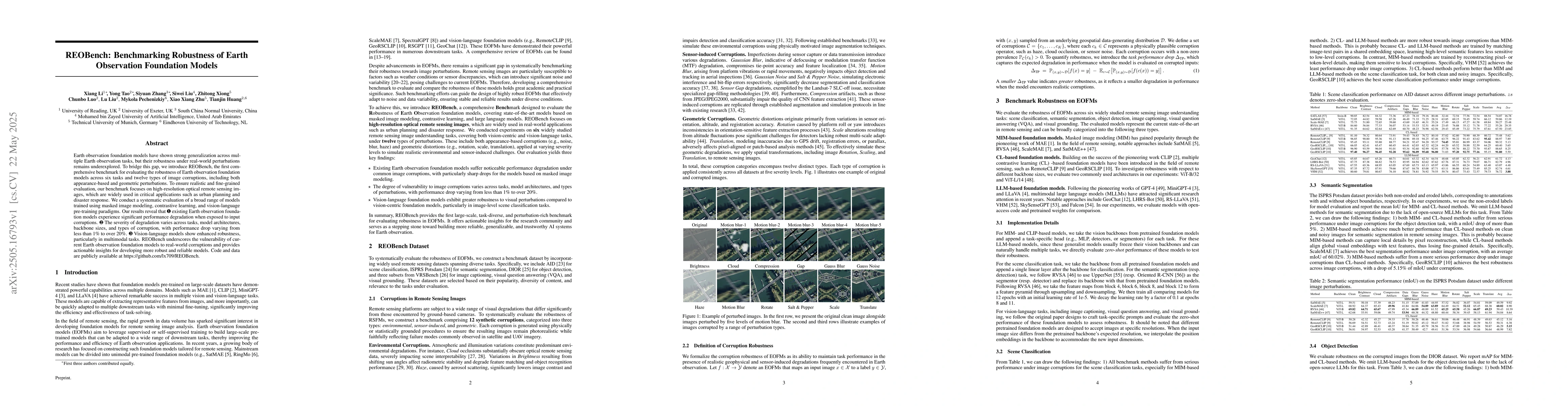
Earth observation foundation models have shown strong generalization across multiple Earth observation tasks, but their robustness under real-world perturbations remains underexplored. To bridge this ...
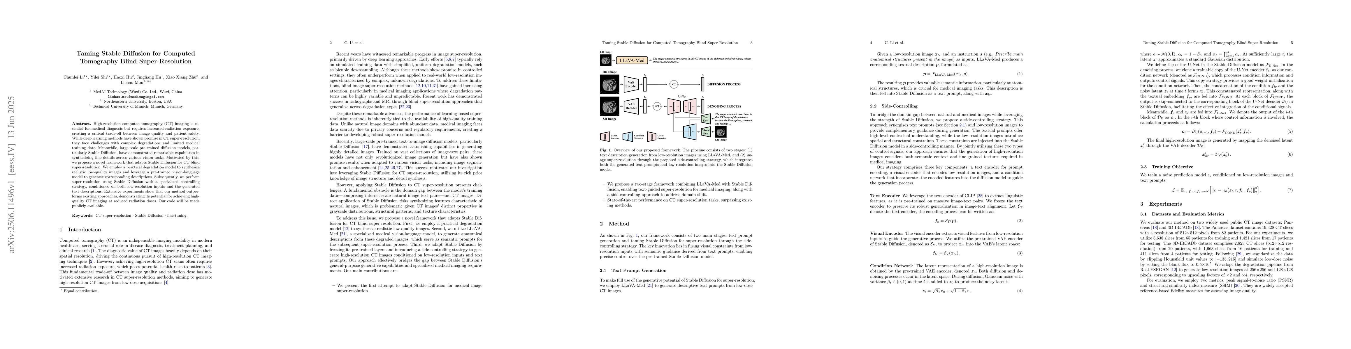
High-resolution computed tomography (CT) imaging is essential for medical diagnosis but requires increased radiation exposure, creating a critical trade-off between image quality and patient safety. W...
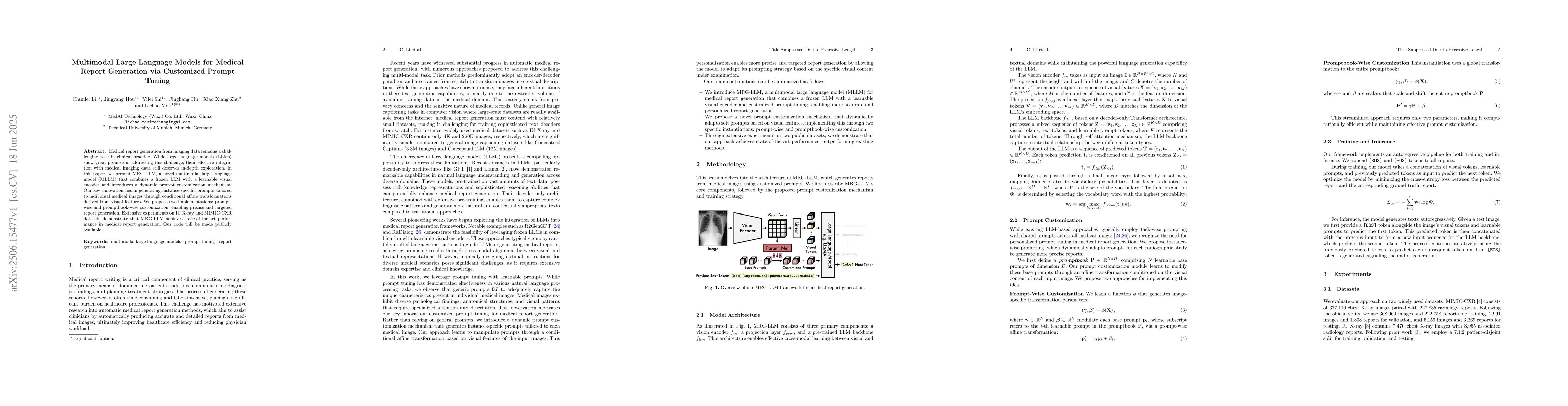
Medical report generation from imaging data remains a challenging task in clinical practice. While large language models (LLMs) show great promise in addressing this challenge, their effective integra...
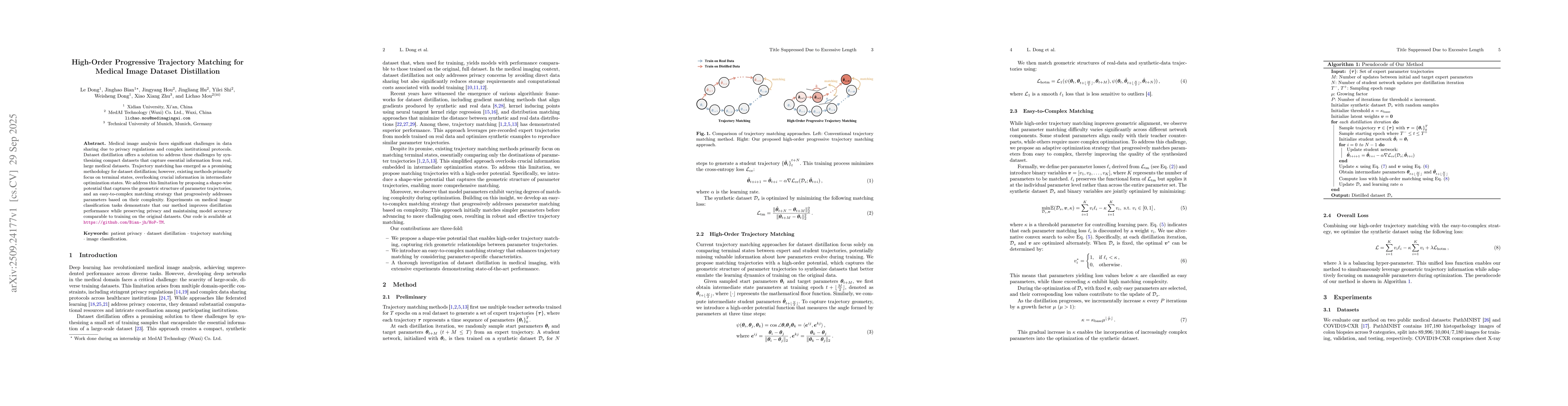
Medical image analysis faces significant challenges in data sharing due to privacy regulations and complex institutional protocols. Dataset distillation offers a solution to address these challenges b...
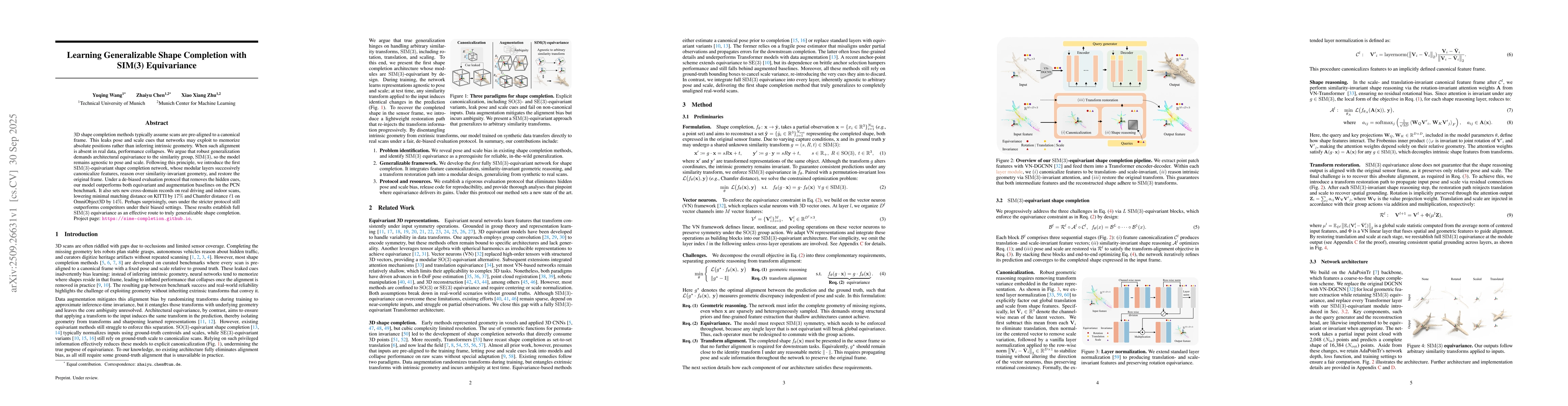
3D shape completion methods typically assume scans are pre-aligned to a canonical frame. This leaks pose and scale cues that networks may exploit to memorize absolute positions rather than inferring i...
Multi-label classification (MLC) offers a more comprehensive semantic understanding of Remote Sensing (RS) imagery compared to traditional single-label classification (SLC). However, obtaining complet...
Mining activities are essential for industrial and economic development, but remain a leading source of environmental degradation, contributing to deforestation, soil erosion, and water contamination....
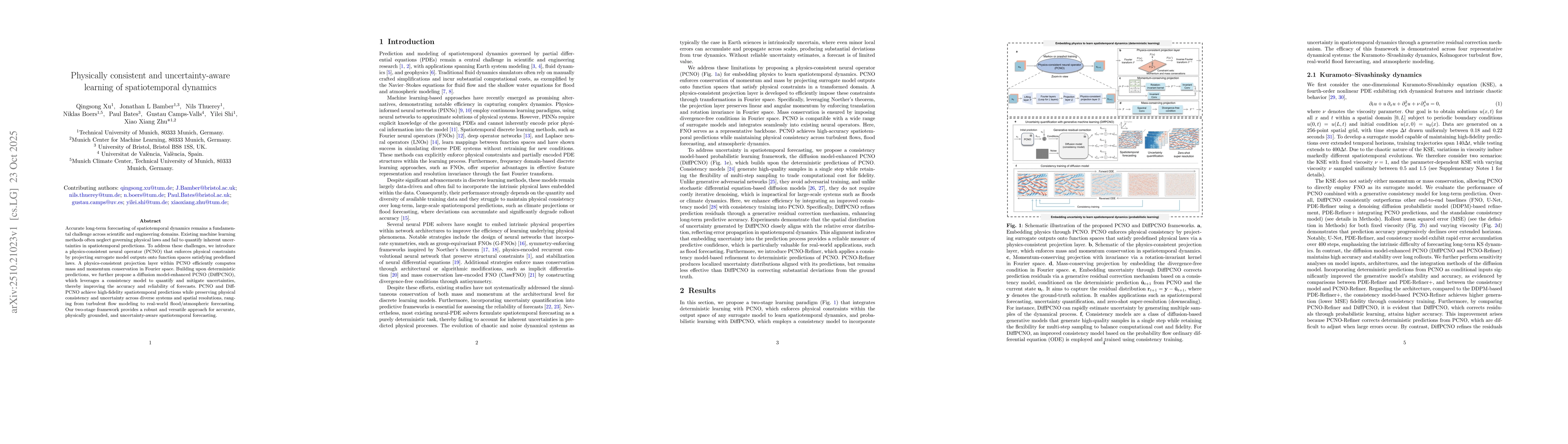
Accurate long-term forecasting of spatiotemporal dynamics remains a fundamental challenge across scientific and engineering domains. Existing machine learning methods often neglect governing physical ...
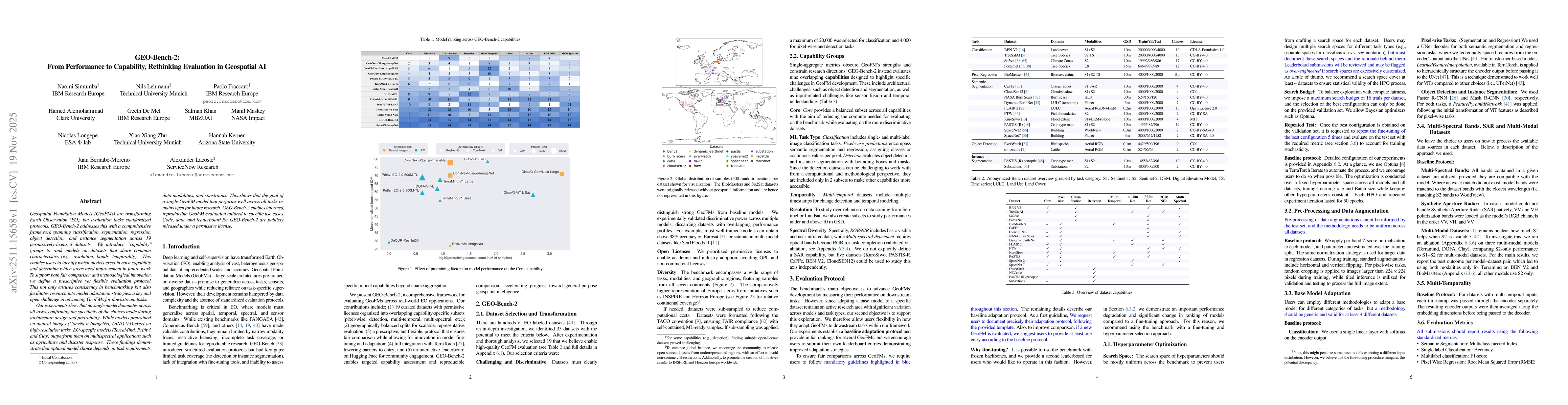
Geospatial Foundation Models (GeoFMs) are transforming Earth Observation (EO), but evaluation lacks standardized protocols. GEO-Bench-2 addresses this with a comprehensive framework spanning classific...
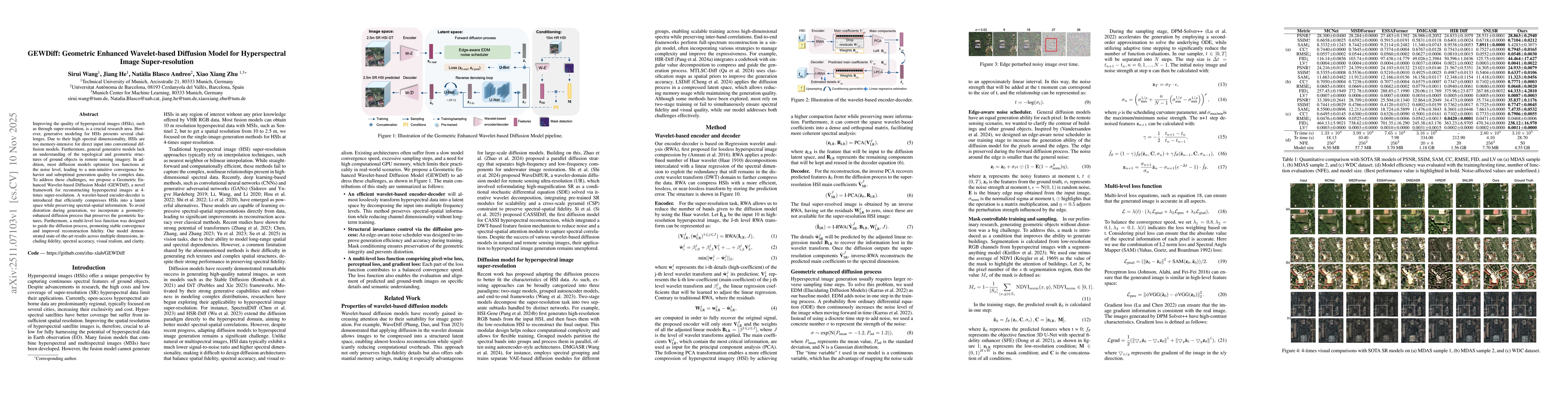
Improving the quality of hyperspectral images (HSIs), such as through super-resolution, is a crucial research area. However, generative modeling for HSIs presents several challenges. Due to their high...
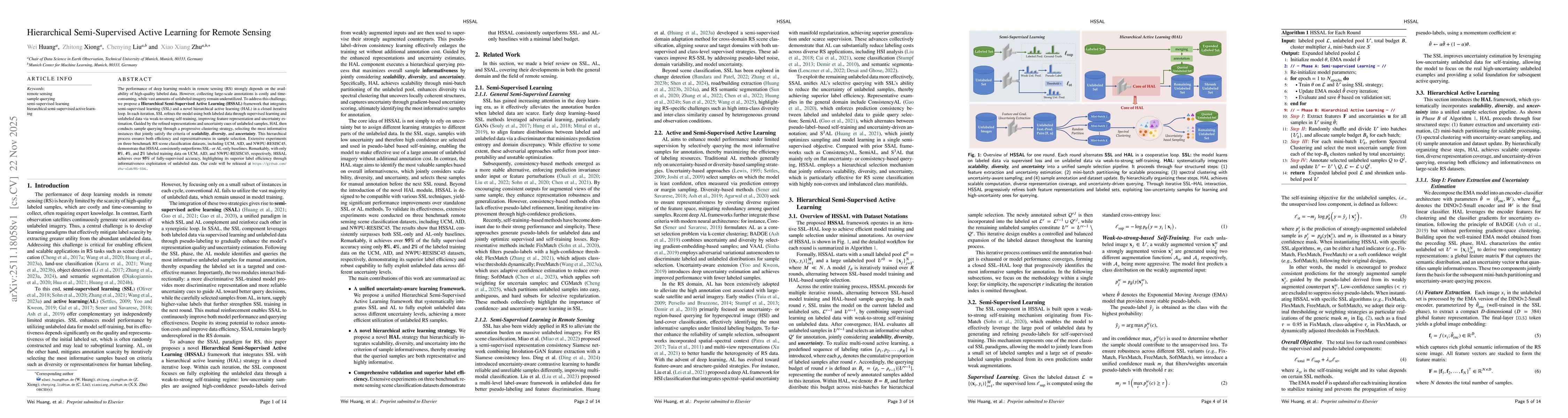
The performance of deep learning models in remote sensing (RS) strongly depends on the availability of high-quality labeled data. However, collecting large-scale annotations is costly and time-consumi...
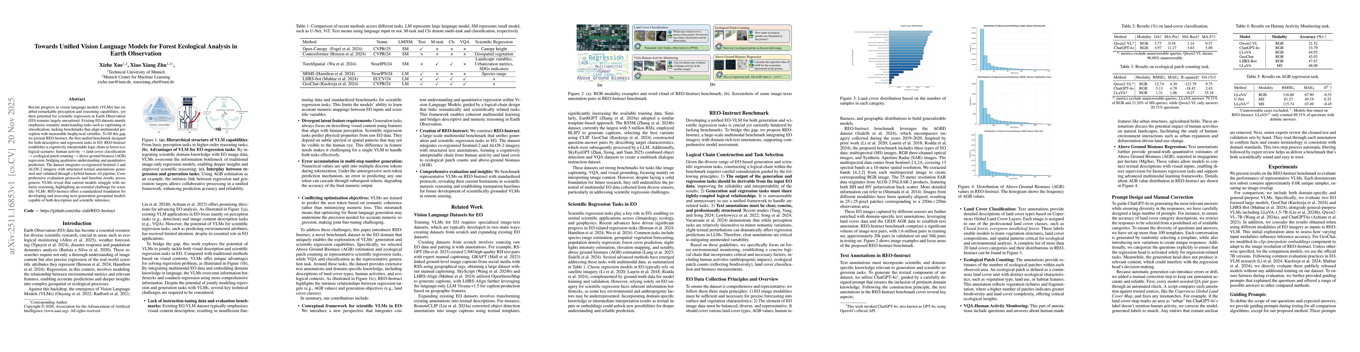
Recent progress in vision language models (VLMs) has enabled remarkable perception and reasoning capabilities, yet their potential for scientific regression in Earth Observation (EO) remains largely u...
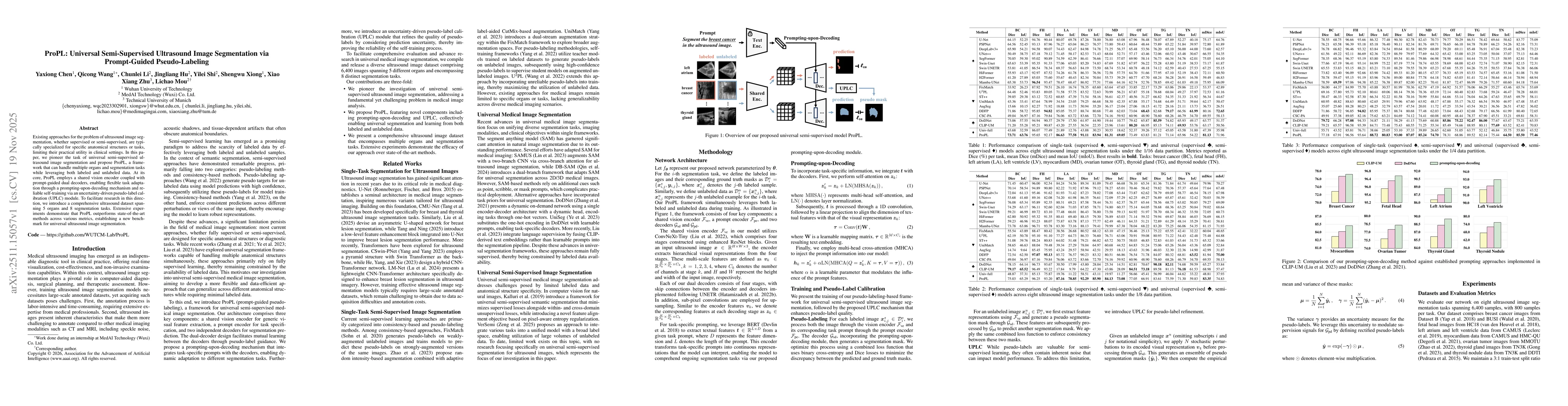
Existing approaches for the problem of ultrasound image segmentation, whether supervised or semi-supervised, are typically specialized for specific anatomical structures or tasks, limiting their pract...
As CLIP's global alignment limits its ability to capture fine-grained details, recent efforts have focused on enhancing its region-text alignment. However, current remote sensing (RS)-specific CLIP va...
Monocular height estimation plays a critical role in 3D perception for remote sensing, offering a cost-effective alternative to multi-view or LiDAR-based methods. While deep learning has significantly...
Land Use and Land Cover (LULC) mapping is a fundamental task in Earth Observation (EO). However, current LULC models are typically developed for a specific modality and a fixed class taxonomy, limitin...
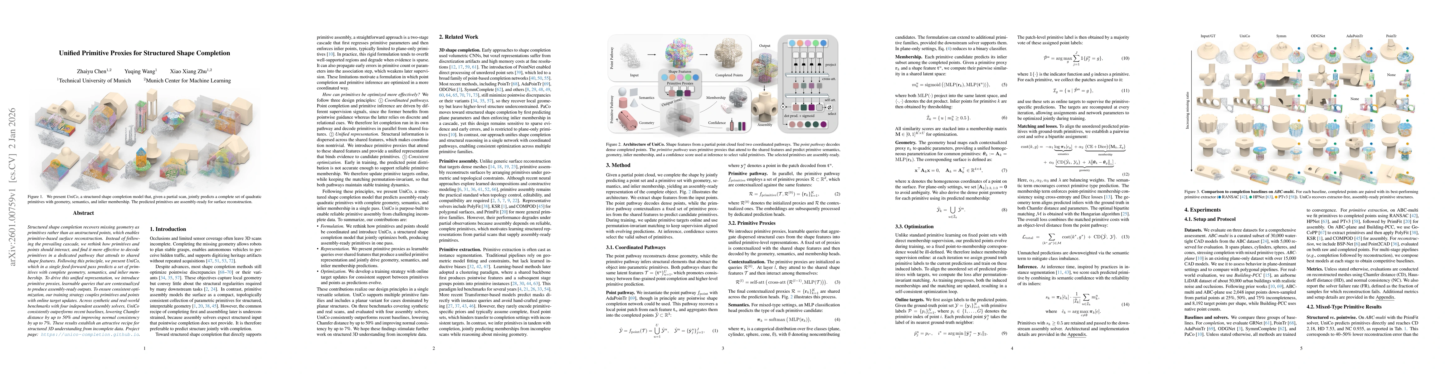
Structured shape completion recovers missing geometry as primitives rather than as unstructured points, which enables primitive-based surface reconstruction. Instead of following the prevailing cascad...
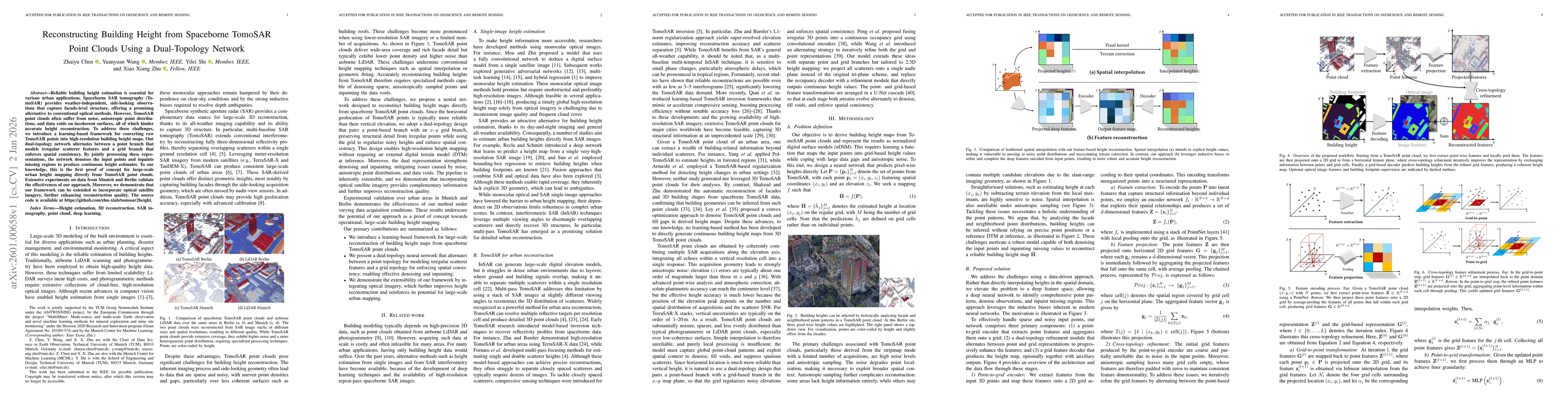
Reliable building height estimation is essential for various urban applications. Spaceborne SAR tomography (TomoSAR) provides weather-independent, side-looking observations that capture facade-level s...
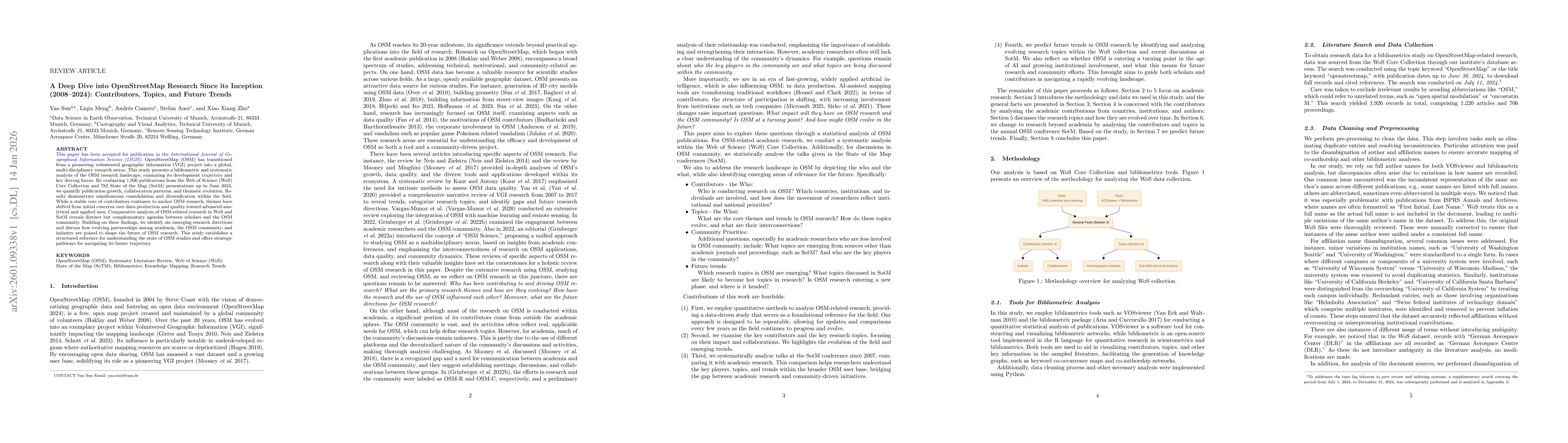
OpenStreetMap (OSM) has transitioned from a pioneering volunteered geographic information (VGI) project into a global, multi-disciplinary research nexus. This study presents a bibliometric and systema...
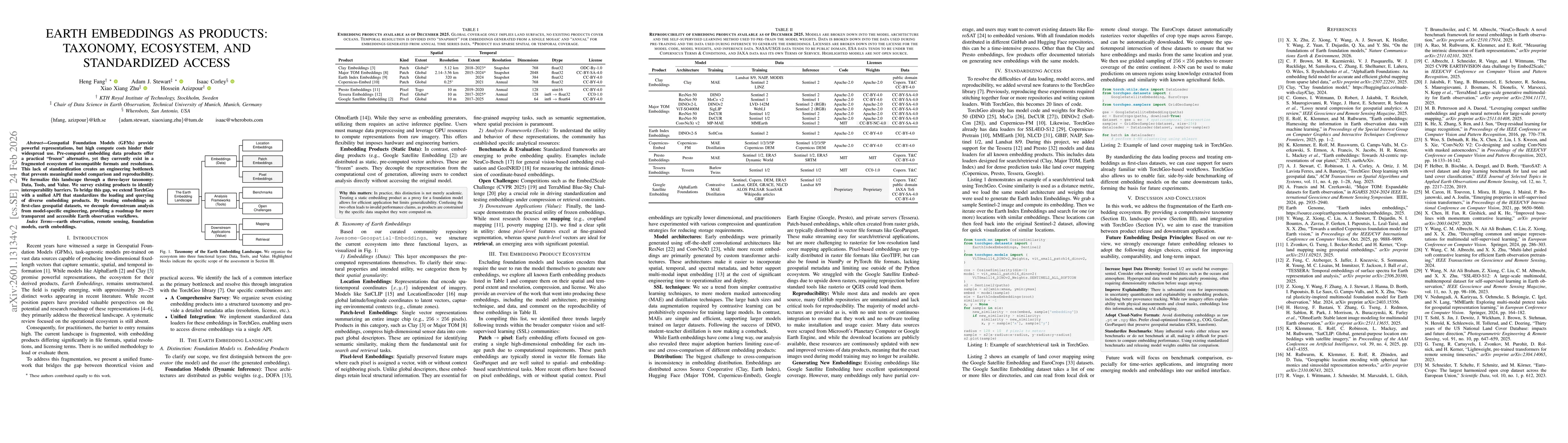
Geospatial Foundation Models (GFMs) provide powerful representations, but high compute costs hinder their widespread use. Pre-computed embedding data products offer a practical "frozen" alternative, y...
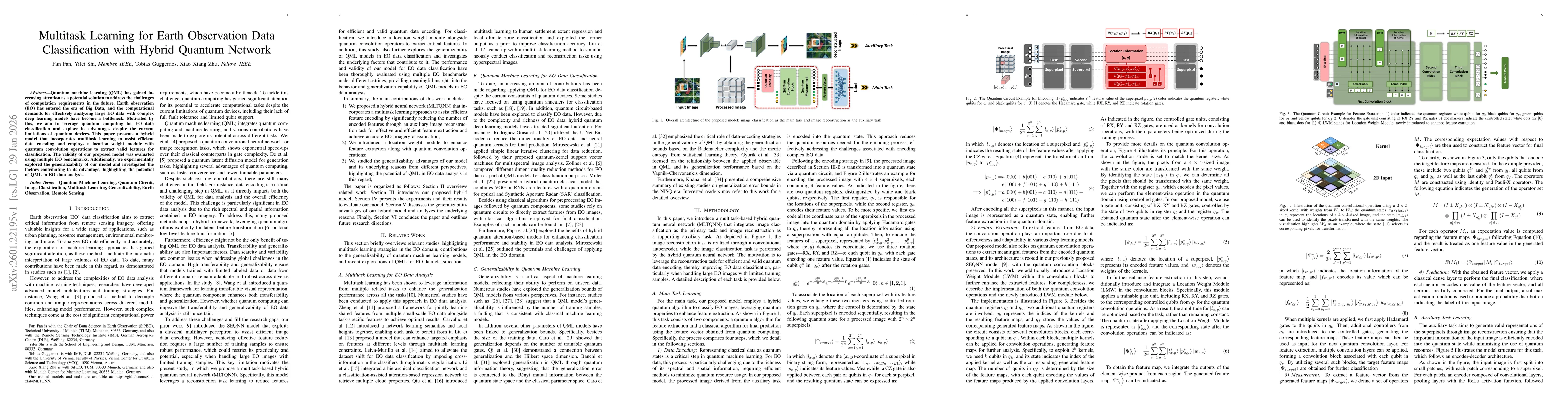
Quantum machine learning (QML) has gained increasing attention as a potential solution to address the challenges of computation requirements in the future. Earth observation (EO) has entered the era o...
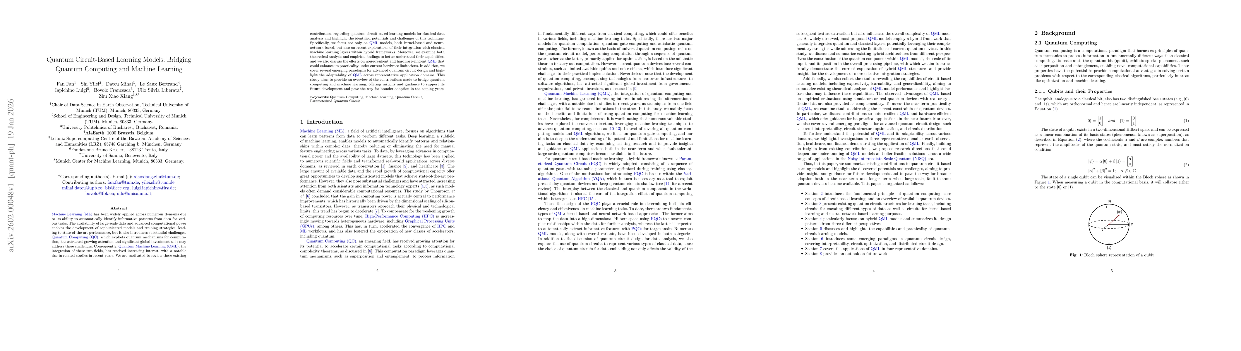
Machine Learning (ML) has been widely applied across numerous domains due to its ability to automatically identify informative patterns from data for various tasks. The availability of large-scale dat...
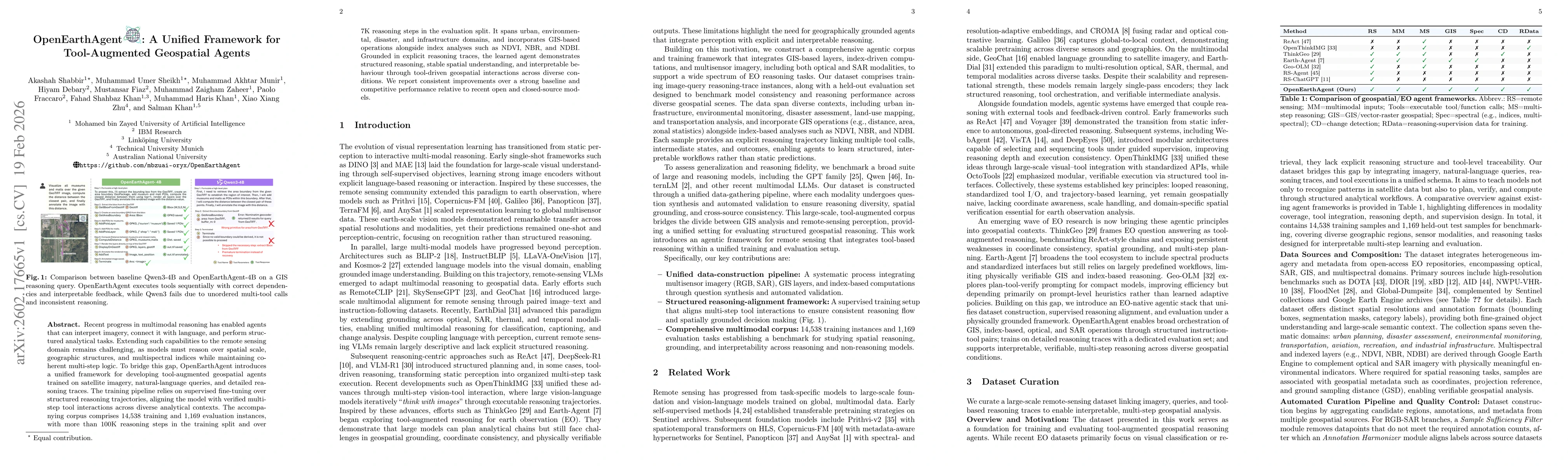
Recent progress in multimodal reasoning has enabled agents that can interpret imagery, connect it with language, and perform structured analytical tasks. Extending such capabilities to the remote sens...
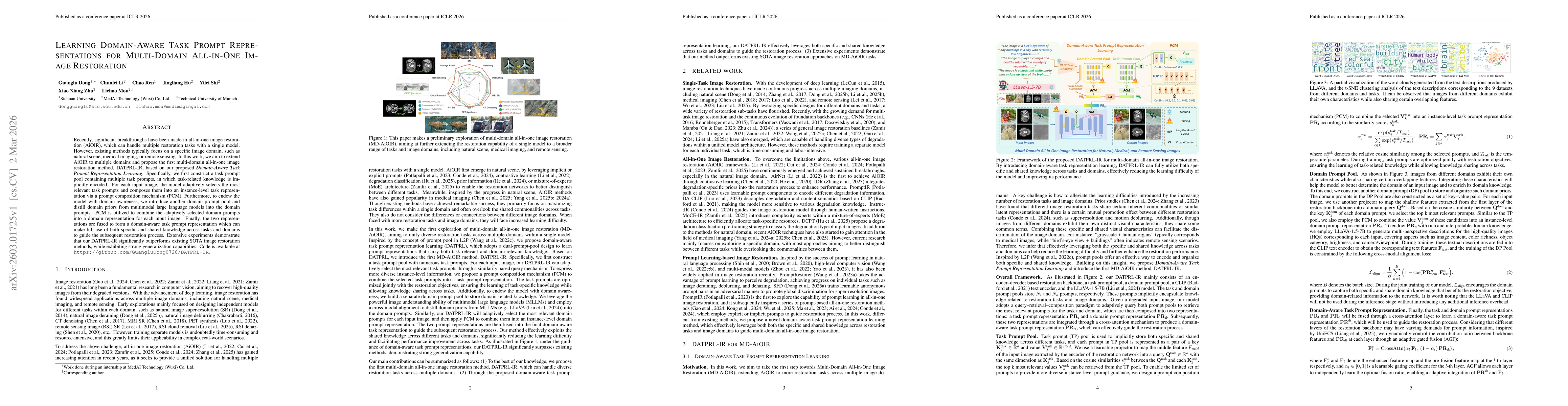
Recently, significant breakthroughs have been made in all-in-one image restoration (AiOIR), which can handle multiple restoration tasks with a single model. However, existing methods typically focus o...
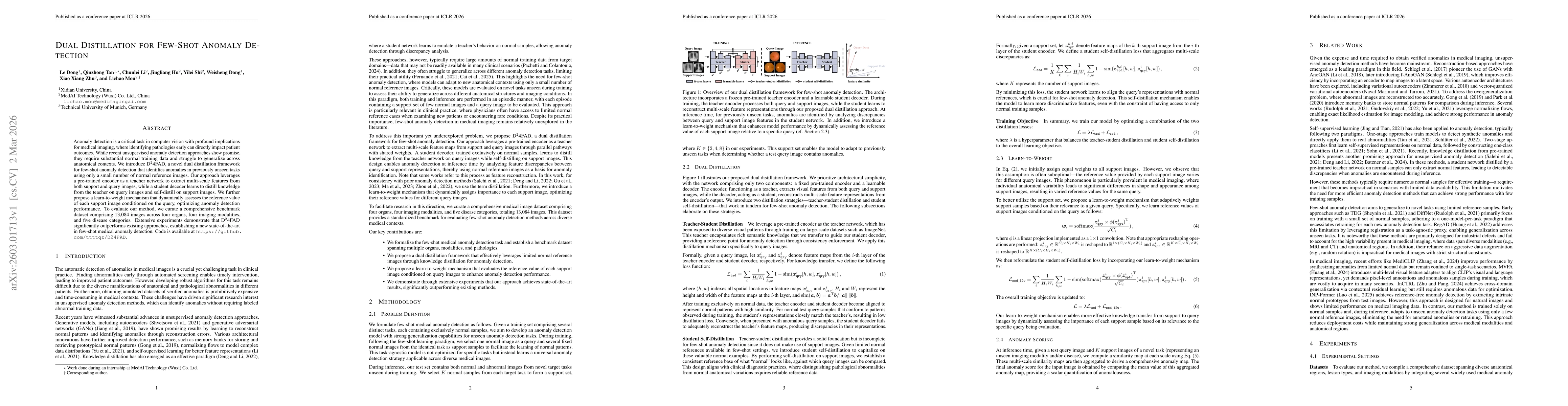
Anomaly detection is a critical task in computer vision with profound implications for medical imaging, where identifying pathologies early can directly impact patient outcomes. While recent unsupervi...
Vision-language models (VLMs) have shown promise in earth observation (EO), yet they struggle with tasks that require grounding complex spatial reasoning in precise pixel-level visual representations....
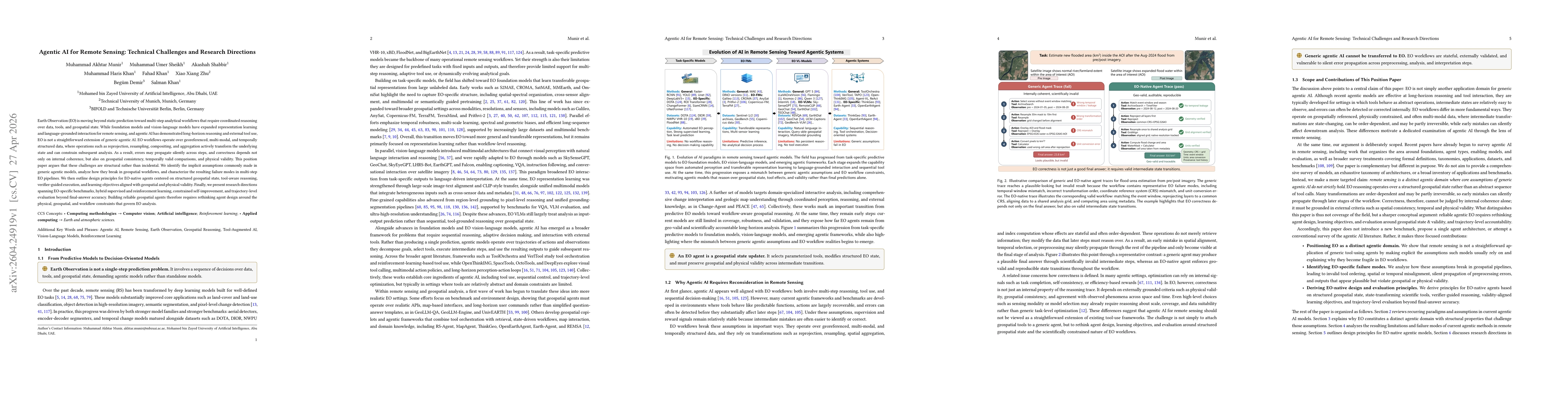
Earth Observation (EO) is moving beyond static prediction toward multi-step analytical workflows that require coordinated reasoning over data, tools, and geospatial state. While foundation models and ...
Mining operations are of utmost importance to the economy of some nations. However, such operations result in land-use change, very high energy consumption, and negative impacts on the environment, in...
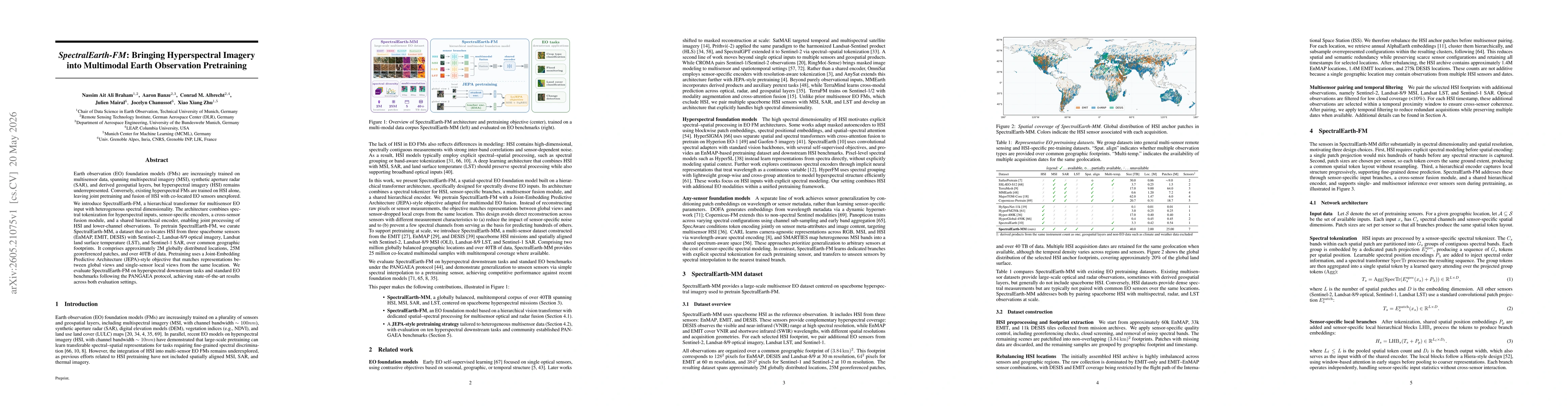
Earth observation (EO) foundation models (FMs) are increasingly trained on multisensor data, spanning multispectral imagery (MSI), synthetic aperture radar (SAR), and derived geospatial layers, but hy...
Mislabeled samples in training datasets severely degrade the performance of deep networks, as overparameterized models tend to memorize erroneous labels. We address this challenge by proposing a novel...
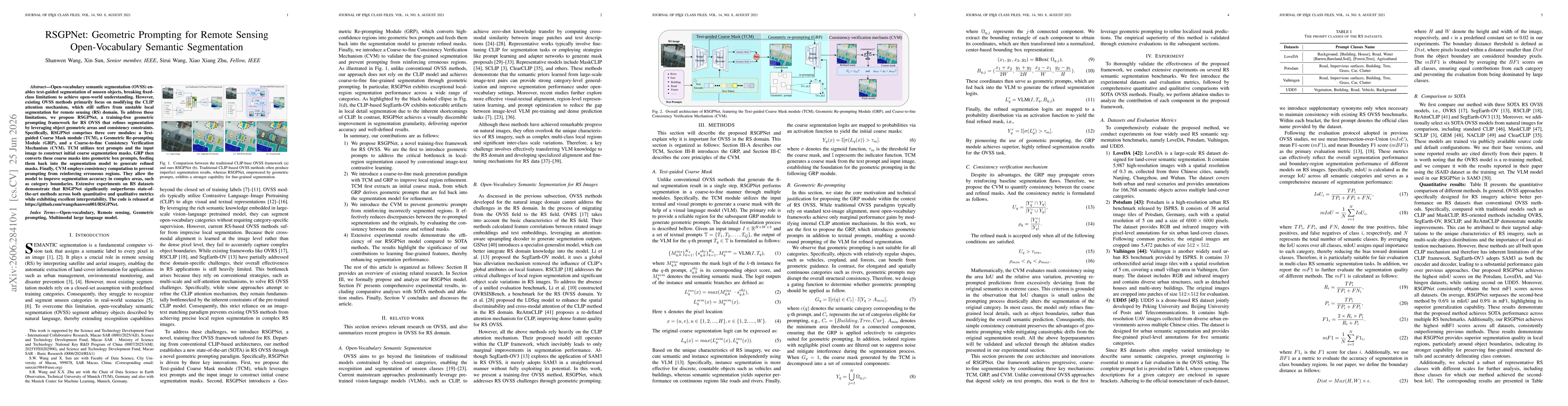
Open-vocabulary semantic segmentation (OVSS) enables text-guided segmentation of unseen objects, breaking fixed-class limitations to achieve open-world understanding. However, existing OVSS methods pr...

Large vision-language models (LVLMs) have achieved strong performance across many medical imaging tasks, yet their application to ultrasound remains limited due to its inherent complexity and variabil...